|
BRYCE CANYON
Guidebook 1941 |

|
 |
BRYCE CANYON NATIONAL PARK UTAH |
|
|
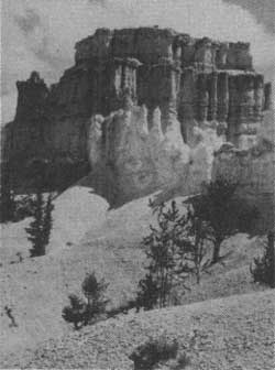
ACCESSIBLE ALL YEAR BRYCE TEMPLE. |
BRYCE CANYON NATIONAL PARK includes some of the most interesting exposures of the Pink Cliffs formation, whose rocks are among the most colorful of any forming the earth's crust. The major beauty spots of the area are found where forces of erosion have cut back into the plateau, forming amphitheaters or wide canyons filled with pinnacles and grotesque forms.
The entire park area, with some 30 miles of Pink Cliffs, can be seen from Rainbow Mountain, at the southern end of the park. Included in this panorama are such beautiful amphitheaters as Black Birch Canyon, Agua Canyon, and Willis Creek. In addition, there are magnificent views across "the land of the purple sage" to Navajo Mountain, 80 miles to the east, and to the Kaibab Plateau and the Trumbull Mountains to the south, the latter 99 miles distant.
In reality Bryce is not a canyon; rather it is a great horseshoe-shaped bowl or amphitheater cut by water erosion into the Paunsaugunt Plateau and extending down a thousand feet through its pink and white marly limestone. The character of the area is well indicated by the Paiute Indian name, "Unka-timpe-wa-wince-pock-ich," which is translated as, "red rocks standing like men in a bowl-shaped canyon." This amphitheater is 3 miles long and about 2 miles wide, and is filled to the brim with myriads of fantastic figures cut by weathering influences, chiefly by running water, wind, and changes in temperature. Domes, spires, and temples predominate, decorated in all the colors of the spectrum, but principally with reds, pinks, and creams.
The park was established September 15, 1928, under authority of the acts of Congress approved June 7, 1924, and February 25, 1928. Under the former act, authority was given for the creation of the Utah National Park, to take in the area then included in the Bryce Canyon National Monument, conditioned upon the transfer of all private land holdings within the proposed park boundaries to the Federal Government. Before these conditions were met Congress passed its 1928 act changing the name of the park to Bryce Canyon National Park and nearly doubling the area contained in the monument. The canyon had been reserved as the Bryce Canyon National Monument by Presidential proclamation June 8, 1923, pending consideration for national-park status and the passing of the necessary legislation to effect this. Under congressional authority of June 15, 1930, President Hoover by proclamations dated January 5, 1931, and May 4, 1931, added 22,320 acres to the park. The total area is now 35,980 acres, or 56 square miles.
GENERAL INFORMATION RELATING TO GEOLOGY OF ZION AND BRYCE CANYON NATIONAL PARKS1
1Condensed from an article by H. E. Gregory, U. S. Geological Survey.
REGIONAL FEATURES.—In Zion and Bryce Canyon National Parks the type of scenery peculiar to the plateaus of southern Utah and northern Arizona attains its most complete expression. Layer upon layer of shales and sand stones have been carved into architectural forms, astonishingly alike for size and color. The long stretches of even skyline seen on approaching the parks from Cedar City (west), Panguitch (north), and Grand Canyon (south) give an impression of extensive flat surfaces that terminate in lines of cliffs, but viewpoints within the parks reveal a ruggedness possessed by few other regions. The canyons are so narrow, so deep, and so thickly interlaced, and the edges of the strata so continuously exposed that the region seems made up of gorges, cliffs, and mesas intimately associated with a marvelous variety of minor erosion forms. The parks might be considered as mountainous regions in which departures of many thousand feet from a general surface are downward rather than upward.
The canyons and adjoining terraces are spectacular illustrations of erosion. They show with diagrammatic clearness the work of running water, rain, frost, and wind, of ground water and chemical agencies active throughout a long period of time. The horizontal tables and benches, broken by vertical lines that in distant view appear to dominate the landscape, are normal features of erosion of plateau lands in an arid climate. The tabular forms are the edges and surfaces of hard strata from which softer layers have been stripped. The vertical lines mark the position of fractures (joints)—lines of weakness which erosion enlarges into grooves and miniature canyons. As they entrench themselves in horizontal layers of rock that vary in resistance to erosion, the master streams and their tributaries are developing stairlike profiles on their enclosing walls. Cliffs in resistant rocks and slopes in weak rock constitute risers and treads that vary in steepness and height with the thickness of the strata involved. Thus near the south entrance to Zion Park the edge of a layer of hard conglomerate is a vertical cliff, its top a platform. Above this platform a long slope of shales, broken by many benches developed in hard beds, extends upward to the great cliff faces of West Temple and the Watchman. In front of Zion Lodge a slope of weak shales leads upward to a cliff of resistant sandstone above which a slope of shale extends to the vertical wall of Lady Mountain. In Bryce Canyon the rim road is on the highest tread of a giant rock stairway that as viewed from Rainbow Point leads downward in steps 30 to 400 feet high to the flat lands 3,000 feet below.
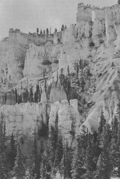
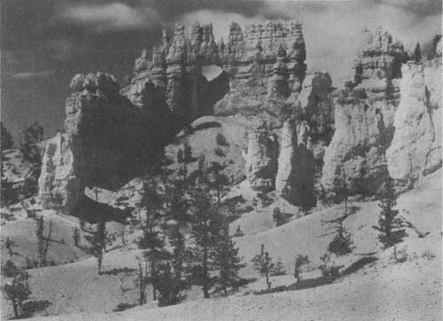
LIBERTY CASTLE AND WINDOW FROM PEEK-A-BOO CANYON. Grant photo
The streams at work in the parks, though relatively small, have steep gradients, including rapids and waterfalls, and are supplied with disintegrated rock material swept from the ledges by torrential rains about as fast as formed. They are therefore powerful agents of erosion, especially in times of flood. The fresh, sharp, angular profile of mesas, ridges, and canyon walls and the extensive areas of bare rock are maintained by the rapid down-cutting and prompt removal of rock waste. The resulting land forms reflect the aridity and the topographic youth of southern Utah and contrast strongly with the rounded hills, the broad valleys, the plant-covered slopes, and the deep soils of more humid regions.
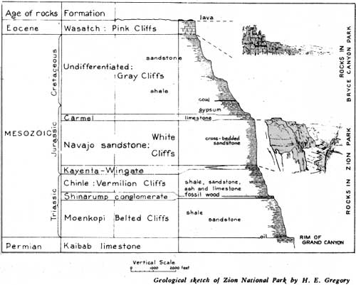
GENERALIZED SECTION OF SEDIMENTS IN ZION AND BRYCE CANYONS.
GEOLOGIC HISTORY.—A large part of geologic history is revealed in the canyon walls of Zion and Bryce Canyon National Parks. Just as Grand Canyon is the best known record of ancient geologic history, Zion Canyon records most clearly the events of medieval geological time, and Bryce reveals much of modern geologic history. The story of Zion begins where that of Grand Canyon ends, and ends where Bryce begins. The rocks exposed in these three national parks incorporate the records of a billion years.
A study of the rocks of Zion and Bryce Canyon shows that during the last 200,000,000 years the region comprising the parks has witnessed many changes in landscape and climate. At times it was covered by the sea, at other times broad rivers traversed its surface, and at still other times it was swept by desert winds. Most of the rocks were laid down by water as gravel, sand, mud, and limy ooze. They have been converted into solid rock by the weight of layers above them and by lime, silica, and the iron that cement their grains. Embedded in the rocks are fossil sea shells, fish, trees, snails, and the bones and tracks of land animals that sought their food on flood plains, in forests, or among sand dunes. The most conspicuous remains are those of dinosaurs—huge reptiles that so dominated the life of their time that the Mesozoic is known as the "age of dinosaurs."
The accumulation of some 8,000 feet of strata (Mesozoic and Tertiary) on top of 4,000 feet of older (Paleozoic) beds, which are exposed in Grand Canyon, may be considered the first of three major events in the development of the marvelous landscapes of the Zion-Bryce region; it provided the material from which the huge scenic features were later carved. The second event was a regional uplift which elevated the previously low-lying top beds of the series (Wasatch, Pink Cliffs) to a height of nearly 2 miles above sea level. As a result of this movement, the earth's crust was broken into huge rectangular blocks by north-south fractures or faults. Three of these great faults can be seen in the vicinity of the parks: the Hurricane fault in the Hurricane Cliffs, west of Zion; the Paunsaugunt fault in the cliffs of Bryce; and the Sevier fault along the Mount Carmel Road between the two parks.
In consequence of the uplift the third major event, the present cycle of erosion, was initiated. The streams became strong and swift and so were able to cut deeply into the underlying rock and carry away the land waste. In this process the streams have removed many cubic miles of rocks which if replaced would fill the present canyons and build up their bordering land to the level of the lofty Markagunt and Paunsaugunt Plateaus. The gigantic features of Zion and Bryce Canyon National Parks mark a stage in the process of erosion that began long ago and which if continued without interruption will convert the present rugged landscape into plains near sea level.
DISTINCTIVE FEATURES OF BRYCE CANYON.—In its regional setting Bryce Canyon National Park is the southeastern border of the extensive Paunsaugunt Plateau. It comprises two areas of strongly contrasted topography that meet in a line that marks the rim of the plateau and the top of its bordering cliffs. Back from the rim the plateau surface on which the park buildings and the automobile roads have been constructed is generally flat land traversed by broad, shallow valleys in which erosion is inconspicuous. Below the rim erosion has produced a region of remarkable ruggedness. It might naturally be supposed that the beautiful amphitheater at the head of Bryce Canyon had been carved by waters pouring down from the plateau above. But the plateau streams contribute nothing; they flow away from the rim. The chief sculpturing agents are the rain and snow that fall directly into the canyon. In producing the amazing variety of erosion features the streams have been aided by frost that pries fragments from the cliffs and by chemical agencies that decompose the rock and supply its vivid color.
The development of the park landscape was made possible by movements within the earth's crust which brought originally low-lying strata to an altitude exceeding 8,000 feet. Streamways on the flat top of this uplifted block were little affected, but with greatly steepened gradients streams around the borders of the newly made plateau became powerful. The Paria and its swiftly flowing tributaries have cut deeply into the face of the Paunsaugunt and carried billions of tons of ground-up rock to the Colorado. At the present time erosion by Bryce Creek, Yellow Creek, Willis Creek, Podunk Creek, and many smaller streams, is causing the plateau face to retreat northwestward, and these streams are taking into their drainage areas channels that formerly carried waters northward to Sevier River.
The drab colored landscape along the southeast border of the park has been developed in alternating beds of shale, coal, and sandstone (Cretaceous age); in the resulting erosion forms, slopes, mounds, rounded ridges, and valleys with inclined or steplike sides predominate. The brightly colored rocks that form the topmost cliffs and terminate abruptly in such headlands as Steamboat Mountain, Bryce Point, and Rainbow Point are resistant limestones of Tertiary age (Wasatch formation). They erode as vertical walls (Pink Cliffs) which weathering has developed into the astonishing display of architectural forms that make Bryce Canyon distinctive.
HOW TO REACH BRYCE
In going to Bryce private motorists should leave the main highway, United States Highway 89, 7 miles south of the town of Panguitch, Utah. Turning to the east, the road follows up Red Canyon, a brilliantly colored little gorge which is often mistaken for Bryce Canyon itself. The approach to Bryce is unusual; no evidence of the canyon is visible until the visitor walks on to the rim and suddenly has revealed to him the great sight in all its breath-taking beauty. Improved highways make Bryce Canyon Park easily accessible, except during the winter.
Travelers by rail may reach the park over the Union Pacific System from Salt Lake City to Cedar City, Utah, thence by motorbus to Bryce.
Busses of the Burlington Transportation Co. and Interstate Transit Lines operate from Salt Lake City and Los Angeles to Cedar City, where passengers going to the park may transfer to busses of the Utah Parks Co. On prior notice, connections may be made with the Santa Fe Trails System at Marysvale.
High-speed de luxe airplane service from all points in the United States to Salt Lake City is available through United Air Lines. Service is also available from Los Angeles by Western Air Express, with stops at Las Vegas, Nev., and Salt Lake City.
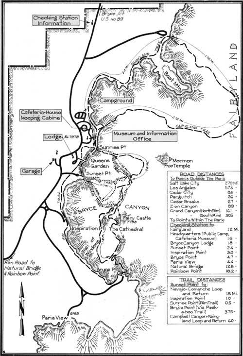
PORTION OF BRYCE CANYON NATIONAL PARK.
(click on image for a PDF version)
ROADS AND TRAILS
The National Park Service has completed an excellent road, which follows the high rim the full length of the park plateau, with short spurs to scenic viewpoints. Twenty miles of paved road now lead to Inspiration Point, Bryce Point, Paria View, the Natural Bridge, and Rainbow Point, at the plateau's end.
The roads are open during spring, summer, and fall, and efforts are made to keep those in the vicinity of headquarters open throughout the winter, except for brief periods during and immediately following storms.
A series of fine horseback and foot trails have been built in the interesting area under the rim. No visitor should leave until he has had close-up views of the formations. Trails lead into Queen's Garden, the Silent City, Fairyland, Wall Street, Peek-a-boo Canyon, and other more remote points, each with its well-named peculiar and distinctive forms. Trails are all easily traveled; horseback trips can be arranged in half- or full-day units to suit the individual.
ADMINISTRATION
Bryce Canyon National Park is administered as a unit with Zion National Park and Cedar Breaks and Zion National Monuments. The representative of the National Park Service in immediate charge is the superintendent of Zion National Park, whose post office address is Zion National Park, Utah. All comments regarding service in the park should be addressed to him.
Information concerning the park is available at the Bryce museum, located near the public auto camp and cafeteria.
NATURALIST SERVICES
A ranger naturalist conducts an auto caravan to various points of interest every afternoon during the summer season, leaving Bryce museum according to schedules posted by the naturalist service.
Each evening at 8:30 illustrated lectures are given at the lodge and at the campfire lecture circle near the public campground by members of the staff, who also conduct short hiking trips into Bryce Canyon, leaving Sunset Point every day of the summer season according to schedules posted by the naturalist service.
Visitors are urged to use these facilities, which are provided free of charge by the Government.

ROADS CONNECTING BRYCE CANYON, ZION, GRAND CANYON, AND CEDAR BREAKS.
(click on image for a PDF version)
ACCOMMODATIONS AND EXPENSES
An attractive lodge is operated by the Utah Parks Co. from about May 30 to September 30. It consists of a central building and cabins. Rates (European plan) are $2.25 per day for 1 person and $3.50 for 2, in "standard" cabins; $5 per day for 1 person, $6.50 for 2, and $8.25 for 3, in "de luxe" cabins (private bath, porch, and fireplace). Meals in the lodge dining room are table d'hote; breakfast $.85, luncheon $.90, and dinner $1.50. Children under 8 are allowed half rate for meals.
There is also a cabin development which is open from about May 1 to October 30. Here are available a cafeteria, food store, and housekeeping cabins. The cabins are $2.50 and $2.75 per day for 1 or 2 persons and $3.75 for 3 or 4. They are equipped with electricity, running water, double beds, cooking stoves, table, sink, shelves, and chairs.
A 15% discount on lodgings is allowed for a stay of one week or more.
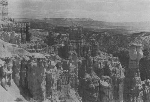
OASTLER CASTLE FROM THE CAMPBELL CANYON TRAIL Grant photo
FREE PUBLIC CAMPGROUNDS
An attractive public auto camp, maintained by the Government, is open from about April 15 to November 15; however, these dates vary according to weather conditions. Pure water and sanitary conveniences are provided, and groceries and campers' supplies may be purchased at the Bryce Camp store. Camping is limited to 30 days a year.
For those not carrying their own equipment and desiring to visit the park after the closing dates of the lodge and camp, there are camps near the park where accommodations can be found at any time of the year.
TRANSPORTATION
Motorbus transportation and all-expense tours to Zion, Bryce Canyon and the North Rim of Grand Canyon National Parks, the Kaibab Forest, and Cedar Breaks National Monument is furnished by the Utah Parks Co., Cedar City, Utah, during the summer season and by special arrangement during the remainder of the year. An automobile trip from Bryce Canyon Lodge to Inspiration Point, Bryce Point, Little Bryce, Natural Bridge, and Rainbow Point and return is offered for $3 per person during the summer.
VIEW ALONG THE RIM ROAD
SADDLE HORSES
Saddle horses may be hired for $1.50 for 2 hours or less, $3 for 2 to 4 hours, and $5 for 8 hours. Daily escorted trips into the canyon cost $3, and those to Natural Bridge are $5. Special guide service, if available, may be obtained for $5 a day or $3 for a half day or less. Riding outfits for women may be rented at the lodge.
POST OFFICE AND COMMUNICATION SERVICE
Bryce Canyon Lodge is provided with post office, telegraph, and long distance telephone service. The post office address during the summer season when the lodge is operating is Bryce Canyon National Park, Utah.
MISCELLANEOUS SERVICES
Fountain service is available in the lodge, and photographs of Bryce may be purchased. Laboratories are maintained for developing and printing.
Curio stores, specializing in Indian handicraft, are operated. Curios, post cards and other items may be obtained at the cabin camps, which carry a complete line of foodstuffs.
Garage service, including storage, repairs, tires, batteries, gasoline, and oil, is provided by the Utah Parks Co. during the regular lodge season.
A registered nurse is on duty at the lodge when it is in operation.
This booklet is issued once a year and rates mentioned herein may have changed slightly since issuance, but the latest rates approved by the Secretary of the Interior are on file with the superintendent and park operator.
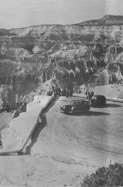
MOTORISTS PARK ON OVERLOOK FOR VIEW OF CEDAR BREAKS Grant photo
CEDAR BREAKS NATIONAL MONUMENT
Twenty miles east of Cedar City, within the Dixie National Forest, where the high plateau breaks away to the west, is a great amphitheater called Cedar Breaks, in the Pink Cliffs formation. The more spectacular part of the formation was created a national monument by the proclamation of President Franklin D. Roosevelt on August 22, 1933, and placed under the administration of the National Park Service. The monument embraces an area of 5,835.79 acres.
While Cedar Breaks is cut from the same geological formation as Bryce Canyon, there is a marked difference between these two scenic areas. There are not countless numbers of outstanding temples, spires, and minarets in the Cedar Breaks bowl, but Cedar Breaks is on a more gigantic scale and has a greater variety of tints. The Pink Cliffs here have a thickness of nearly 2,000 feet, and 47 different shades of color have been distinguished.
The heavily forested rim attains an altitude of 10,700 feet. The cliffs are white or orange at the top, breaking into tints of deep rose and coral. The high elevation also affords an excellent distant view of mountains and desert.
The Utah Parks Co. has provided a comfortable lodge with an attractive dining room, lobby, and rest rooms. Sleeping accommodations are available in cabins operated in connection with the lodge at the rate of $2.25 for 1 and $3.50 for 2 persons in a standard cabin room. Housekeeping cabin rooms are $2.50 per day for 1 or 2 persons, including blankets, linen, and maid service. Dining service at Cedar Breaks Lodge is a la carte or table d'hote; breakfast $.50 to $.85, luncheon $.90, and dinner $1.50. Groceries, campers supplies, gasoline, and oil may be procured. Cedar Breaks Lodge is open from about June 1 to September 20.
A free public campground is maintained where water, cooking fireplaces, and fuel are furnished.
The season of accessibility varies with weather conditions, but is usually from early June to the first of November. On account of the high altitude, snows persist until late spring. During the summer season, the National Park Service maintains an information office and small museum near the parking area at Point Supreme.
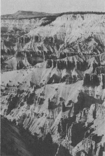
CEDAR BREAKS
RULES AND REGULATIONS
[Briefed]
THE PARK REGULATIONS are designed for the protection of the natural beauties and scenery, as well as for the comfort and convenience of visitors. The following synopsis is for convenient reference and general guidance of visitors:
PRESERVATION OF NATURAL FEATURES.—The parks are established primarily for preservation of natural features. Do not destroy or disturb flowers, trees, animals, etc. Writing on or otherwise defacing rocks and other natural features is strictly prohibited. Hunting and the use of firearms are prohibited.
CAMPING.—Camp only in established campgrounds. Keep your camping area clean. BE CAREFUL WITH FIRE. Lunching and picnicking are prohibited except in public auto camp. Camping limited to 30 days.
DISORDERLY CONDUCT.—Proper conduct is required of all visitors for the benefit of others who are entitled to get the fullest possible enjoyment from the park.
PETS.—If you are carrying a dog, cat, or other pet, you may take it into and through the park provided it is at all times kept tied or confined within the car. Pets are not permitted in public buildings or on trails.
TRAILS.—Do not attempt to make short cuts; to do so you may endanger yourself as well as others using the trails. Before attempting more difficult trails seek advice from a park ranger.
AUTOMOBILE REGULATIONS.—(a) Permit.—A charge of $1 for each automobile is made at Bryce Canyon and Zion National Parks. One permit is good for both parks, and is good for the remainder of the year in which issued. House trailer fee, $1.
(b) Careful driving.—The roads in the park are built purely for scenic purposes, not as high-speed thoroughfares. Observe speed limits and the usual rules of the road; keep to right, do not park on curves, pass cars going in the same direction only when the road ahead is clear and the vision unobstructed. The speed limit in the park is 35 miles per hour.
PENALTIES.—Maximum penalty for violation of park regulations is $500 and/or imprisonment for 6 months.
MISCELLANEOUS.—The park rangers are employed to help and advise visitors as well as to enforce regulations. When in doubt, ask a ranger. A complete copy of the park rules and regulations is available on request.
Let no one say, and say it to your shame,
That all was beauty here until you came.
| <<< Previous | <<< Contents>>> |
1941/brca/sec1.htm
Last Updated: 20-Jun-2010