|
COLORADO
Guidebook 1958 |

|
| Colorado | NATIONAL MONUMENT |
Colorful and spectacular erosional forms, including massive ramparts, sheer-walled canyons, and gracefully sculptured spires, here reveal significant chapters of earth history.
Colorado National Monument is an area of fantastically eroded and vividly colored highlands. Its sheer-walled canyons, towering monoliths, stratified ramparts, and fluted columns combine to present a spectacle of imposing grandeur. Red is the predominant color, making the name "Colorado"—the Spanish word meaning "red"—especially appropriate.
|
The National Park System, of which this area is a unit, is dedicated to conserving the scenic, scientific, and historic heritage of the United States for the benefit and enjoyment of its people. |
HISTORY
In 1776 the famous Escalante-Dominguez Expedition penetrated this region. This Spanish expedition was the first European invasion of what was then the country of the Uncompahgre Ute Indians. And it marked the first time that the wonders of the monument area had been viewed by other than Indian eyes. Probably the next Europeans to traverse this part of Colorado were trappers and traders, who were particularly active between 1815 and 1845.
Fort Robidoux was established near the present town of Delta during the 1820's; it was visited by Marcus Whitman on his journey from Oregon to the Nation's Capital in 1842. In 1853, Capt. John W. Gunnison surveyed a railroad route to the Pacific. Each of these parties passed along the Colorado River Valley near the present monument.
Soon after 1881, when the Utes were pushed into Utah, the towns of Grand Junction and Fruita were founded. During the ensuing years many settlers moved into the area. Among them was John Otto, who eventually settled to live a hermit's life in Monument Canyon, where he began building trails and otherwise promoting the beauty of this canyon country. By 1907 he had interested enough townspeople to have a petition drawn up asking that this area be set aside as a National Monument. On May 24, 1911, Otto's dreams came true when the Presidential proclamation creating the monument was signed.
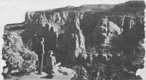
"The Monuments" of Monument Canyon as seen from the campground
NATURAL FEATURES
The monument is part of the vast upland area flanking the Colorado River on either side of Grand Valley. The deep-red sandstone has been carved by action of wind and water through eons. Colossal natural amphitheaters, dwarfing man and his works, have been formed. In the process, giant monoliths have been hewn out of the sandstone. Most prominent among these sand stone shafts is 500-foot Independence Monument. In the great red walls and canyon amphitheaters have been found petrified wood, fragments of dinosaur bones, and limited evidence of early habitation by Indians.
Weird formations come into view at every turn of the road. Balanced Rock, Coke Ovens, Monolith Parade, and Window Rock are but a few of the intriguing features visible from the transmonument scenic drive which skirts the cliffs of Red, Ute, and Monument Canyons. To the northward, Book Cliffs form the skyline and mark the opposite side of Grand Valley. Grand Mesa, one of the most famous of flat-topped mountains, looms to the eastward. Grand Valley, nearer at hand, to the northeast, unfolds with its symmetrical pattern of farms and orchards.
GEOLOGY
Colorado National Monument contains interesting geological exhibits produced in the red sandstone formations by various processes. These include original deposition of sediments, faulting and displacement of large blocks of the earth's crust, and weathering—the ever-present erosional action of wind, water, and temperature.
Erosion. Nature's sculptors, wind and water, are most directly responsible for the scene you see today. But before their work could begin, sedimentation and faulting provided the raw materials. First, gravel, sand, silt, and mud sediments were deposited in this area. Then, at about the time the Rocky Mountains were being formed, tremendous earth forces lifted what we now call the Uncompahgre Plateau above the surrounding country. This displacement created the 10-mile fault escarpment that runs through the monument and overlooks the Grand Valley. The elevation of the plateau meant accelerated erosions as water from melting snows and mountain thundershowers rushed down ward toward the river. Over a great length of time, hundreds of feet of rock were removed. Rocks like those that make up the Book Cliffs and Grand Mesa once also covered this plateau but have washed away.
Small canyons began to take form, as streams flowed along fractures in the thick sandstone layers. Undermining of the softer sections caused a continual breaking off of layers above by a process known as sapping. Thus as the canyons were being cut deeper, they also widened. Occasionally this sapping action widened two adjoining canyons so much that the ridge between them was chiseled into finlike thinness. As weathering continued, these thin ridges were cut through, leaving isolated columns of rocks or monoliths. Independence Monument is the best example of this.
The Fault. One of the monument's more spectacular features is the fault. It is the result of great pressures being exerted against the earth's crust from within. Finally, the crust cracked along a 10-mile front, producing a vertical displacement of hundreds of feet. Thus layers of sandstone were exposed like leaves in a book. You can see this displacement by comparing the elevation of one of these layers, the Morrison formation, in different parts of the monument—it occurs high up in the cliffs of the escarpment, but near the river it is found in the valley floor. (The dinosaur beds near the river are in this formation—fossils of five species of dinosaurs have been found there.)
At either end of the 10-mile-long fault, the pressure was less intense and the sandstone layers were bent rather than faulted. This is particularly well seen in Fruita and No Thoroughfare Canyons, and from Window Rock.
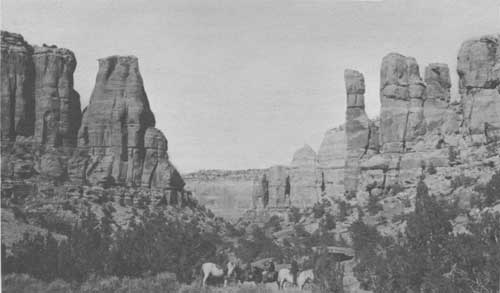
Monument Canyon
WILDLIFE, TREES, AND FLOWERS
The monument is a wildlife sanctuary where hunting is prohibited. Deer, fox, coyote, and porcupine are plentiful, as well as many species of birds. Elk are occasionally seen. In the mid-1920's, a few bison were transplanted to the monument. The herd, now maintained at 20 head, the maximum for which there is forage, may be seen occasionally from Rim Rock Drive grazing on the canyon floors or along the base of the great valley escarpment.
The forest cover is chiefly juniper and piñon pine, interspersed with several species of brush and shrubs such as sagebrush, serviceberry, and mountain-mahogany. A wide variety of wildflowers may be seen in early summer.
GETTING TO THE MONUMENT
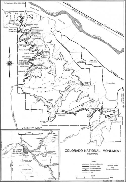
The eastern entrance to the monument is 4 miles from Grand Junction and the northern entrance is 3-1/2 miles from the town of Fruita. U. S. 6, 24, and 50 converge at Grand Junction, and 6 and 50 pass through Fruita, making the monument easily accessible. An excellent year-round road traverses the monument, following the canyon rims for most of its 22 miles. Along the route are parking overlooks where you may enjoy the spectacular beauty. The two entrances permit those en route east or west to go through the monument, or to take a circle trip through the monument via Grand Junction or Fruita.
FACILITIES
Campgrounds and picnic areas, equipped with tables, benches, fireplaces, water, fire wood, and sanitary facilities, are provided at monument headquarters. Camping supplies and equipment are not obtainable in the monument. Hotel and tourist camp accommodations are available in nearby towns.
VISITOR USE FEES
Fees for 15-day or annual permits are collected for each automobile, motorcycle, and housetrailer entering the monument. During its valid period, the cost of the 15-day permit may be applied toward the annual permit. All fees are deposited as revenue in the U. S. Treasury and offset, in part, appropriations made for operating the monument.
PROTECTING THE MONUMENT
To help us protect this monument—and also for your safety—the following synopsis of National Park Service regulations is offered for your guidance:
The monument is a sanctuary for wildlife; hunting and the use of firearms are not permitted.
Flowers, shrubs, and trees should not be disturbed or wild animals or birds harmed or frightened. Initials must not be carved on signs or structures. Natural features must not be marred or defaced.
Be careful with fire. Be sure cigarettes and matches are out before discarding them. Build campfires only at designated places in the campground. Use sparingly only the wood prepared and placed there. Extinguish campfires completely before leaving them.
Please help keep the monument premises clean. Deposit all refuse in trash cans.
Rocks or other objects must not be thrown or rolled into the canyon. This practice is destructive to the monument's natural beauty and is dangerous to persons who may be in the canyon below.
Hiking or climbing alone is dangerous. You should check with the superintendent or a ranger as to destination and trail conditions.
Dogs and cats must be kept on leash or otherwise under physical restraint.
The speed limit is 35 miles an hour and speed must be reduced on sharp and blind curves. Avoid accidents by driving carefully.
MISSION 66
Mission 66 is a program designed to be completed by 1966 which will assure the maximum protection of the scenic, scientific, wilderness, and historic resources of the National Park System in such ways and by such means as will make them available for the use and enjoyment of present and future generations.
ADMINISTRATION
Colorado National Monument, containing an area of almost 28 square miles, was established by Presidential proclamation on May 24, 1911. It is administered by the National Park Service, U. S. Department of the Interior. A superintendent, whose address is Box 157, Fruita, Colo., is in immediate charge.
Colorado National Monument
(click on image for a PDF version)
| <<< Previous | <<< Contents>>> | Next >>> |
1958/colm/sec1.htm
Last Updated: 20-Jun-2010