|
CRATER LAKE
Guidebook 1940 |

|
| ACCESSIBLE ALL YEAR |
 |
Crater Lake NATIONAL PARK OREGON |
||
|
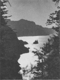
PHANTOM SHIP
| ||||
LOCATED in southern Oregon, on the crest of the Cascade Range, Crater Lake National Park has a high place among the Nation's most scenic wonderlands. At Crater Lake visitors observe beauty in its truest sense and experience a profound inspirational appeal. Tranquillity now prevails where once unfathomable volcanic power was displayed.
The lake rests in the heart of a mighty mountain whose destruction resulted in the formation of a vast crater in which the waters accumulated. It is 6 miles wide, 2,000 feet deep, covers an area of 20 square miles, and has a shore line of 26 miles, with multi-colored cliffs rising 500 to 2,000 feet above the lake.
Trails lead to high points on the rim and to the shore of the lake. Launches and rowboats are available for scenic trips and trout fishing. Daily launch trips are scheduled around the lake shore line and to Wizard Island. A paved road extends around the crater rim, a distance of 35 miles, presenting scores of enthralling views of the lake.
The ever changing color of lava cliffs and blue water are beautiful beyond description.
Crater Lake National Park, established May 22, 1902, embraces an area of 250.52 square miles.
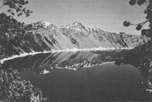
CRATER LAKE REFLECTS THE WATCHMAN AND HILLMAN PEAK. Aldrich photo
DISCOVERY AND HISTORY
History says that the Klamath Indians knew of, but seldom visited, Crater Lake before its discovery by white men. The Indians knew the lake and the mountain as the battleground of the gods.
Crater Lake was discovered on June 12, 1853, by John Wesley Hillman, a young prospector leading a party in search of the "Lost Cabin Mine." Having failed in their efforts to find the mine, Hillman and his party on returning to Jacksonville, Oreg., a mining camp in the Rogue River Valley, reported the discovery of a lake which they had named Deep Blue Lake, located high in the Cascade Mountains.
Hillman's discovery was apparently forgotten in the excitement of gold discoveries and Indian wars. On October 21, 1862, Chauncey Nye, leading a party of prospectors from eastern Oregon to Jacksonville, happened upon the lake. Thinking that they had made a discovery, they named it Blue Lake. A third "discovery" was made on August 1, 1865, by two soldiers stationed at Fort Klamath, who called it Lake Majesty. In 1869 this name was changed to Crater Lake by visitors from Jacksonville.
Before 1885 Crater Lake had few visitors and was not widely known. On August 15 of that year William Gladstone Steel, after 15 years of effort to get to the lake, stood for the first time on its rim. Inspired by the beauty of the lake and its surroundings, Judge Steel conceived the idea of preserving Crater Lake as a national park. For 17 years more Steel, with much personal sacrifice, devoted time and energy to the establishment of Crater Lake National Park. Success was realized when the park was established May 22, 1902. Steel devoted the remainder of his life to development of the park, serving as its second superintendent and later as park commissioner, which office he held until his death in 1934.
THE GEOLOGIC STORY OF CRATER LAKE
ORIGIN OF THE MOUNTAIN.—Geologists tell us that the slope which visitors ascend to view the lake, and the crater wall rising 500 to 2,000 feet above the water, form the remnant of a mountain which stood more than 12,000 feet high. This ancient peak which is now destroyed is known as Mount Mazama.
In comparatively recent geologic time numerous volcanic peaks were formed near the western edge of a vast lava plateau covering portions of Oregon, Washington, Montana, Idaho, Nevada, and California. The peaks bordering this plateau form the Cascade Range. Mount Mazama at Crater Lake was one of the commanding peaks of the range.
The mountain remnant cupping Crater Lake was built by the pouring out of lava flows and to some extent by the accumulation of volcanic ash. The volcanic cone thus formed was modified by streams and glaciers which carved valleys in its sides and deposited rock debris on its flanks. The layered character and different formations of the mountain are clearly exposed in numerous places in the crater wall.
LAVA OUTPOURINGS THROUGH SPLITTING OF THE MOUNTAIN.—In addition to the extrusion of broad lava flows, it is common for great quantities of molten lava to penetrate and fill cracks or fissures that develop in a volcano. Such filling results in dikes or walls of rock frequently harder than the enclosing rock. At Crater Lake the destruction of the mountain and subsequent erosion have exposed numerous dikes in the wall, of which the Devil's Backbone on the west side of the crater is the outstanding example.
ACTION OF STREAMS AND GLACIERS ON THE MOUNTAIN IN THE COURSE OF ITS BUILDING.—In the layers forming the crater wall there is evidence of the action of water. In some places this is shown by the cutting of valleys; at others, by the accumulation of water-carried gravel, and boulders.
Glacier ice carrying sand, pebbles, and boulders scratches and polishes rock surfaces over which it moves. Glacial polish and thick beds of glacial debris are common around the mountain. They occur on the surface rock and between earlier layers, showing that glaciers existed at various stages in the history of the mountain.
U-shaped valleys such as Kerr Notch, Sun Notch and Munson Valley on the southeast slope of Mount Mazama are evidence of glaciation. The lava flow forming Llao Rock filled an ancient glacial notch.
FORMING OF THE CRATER.—The broken edges of rock layers clearly exposed in the crater wall indicate widening of the crater in all directions. Increase in the size of the summit crater of the mountain, which eventually formed the present crater, is probably due to explosive activity followed by the collapse of the peak.
Recent investigations by Howel Williams have led him to conclude that the crater owes its origin principally to collapse or engulfment of the mountain peak.
Formation of the crater by collapse was first proposed by J. S. Diller of the Geological Survey. Diller's explanation differs from that of Williams' principally in the method by which the void beneath Mount Mazama was formed. Diller thought that quantities of molten rock drained away through subterranean passages, thus weakening the support of the mountain peak and causing ultimate collapse.
In a report to be published by Williams, he describes great quantities of pumice extending more than 80 miles northeast of Mount Mazama. This pumice is equivalent to more than 20 cubic miles of material and is thought to have been blown from the mountain in a catastrophic event and carried northeastward by the prevailing winds. Analysis of this pumice shows that it is new material derived from the magma within the volcano and not finely divided fragments of the original mountain walls.
Following this explosion the mountain is thought to have literally boiled over, pouring out great quantities of frothy magma which flowed down the mountain. The greater quantity extended to the south and southwest for distances up to 35 miles. This material poured out from the crater as a series of avalanches which must have flowed at a terrific speed, for those on the south and west sides of the mountain did not begin to deposit their load until they reached a distance of 4 or 5 miles from the crater.
Accompanying these explosions and ejection of this lava material, cracks developed in the flanks of the mountain and eventually the top collapsed, being engulfed in the void produced by the ejection of the pumice and molten rock, thus forming the crater as we see it today.
By projecting the slopes of the remnant of the mountain upward, conforming to the slopes of similar volcanoes, it has been estimated that approximately 17 cubic miles of the upper part of ancient Mount Mazama was destroyed.
TOWARD THE CLOSE OF THE ACTIVITY FORMING THE CRATER, MINOR ERUPTIONS PRODUCED WIZARD ISLAND AND POSSIBLY OTHER CONES.—After the destruction of the peak, volcanic activity within the crater produced Wizard Island and perhaps other cones. These cones rise above a relatively flat floor, the lowest part of which is almost 2,000 feet be low the present lake surface. Forming the crater floor probably involved many stages during some of which the crater may have been occupied by wide stretches of molten lava.
ORIGIN OF THE LAKE.—The water of Crater Lake is derived from rainfall and snowfall over the crater, together with snow blown into the depression. The lake is not known to have an outlet except by seepage. The conditions of evaporation, seepage, and precipitation are in a state of balance which makes possible this accumulation of water and maintenance of approximately this water level. If the region were at a different altitude, or in a different location, the lake might not have been formed.
The existence of Crater Lake was made possible by the building of a mountain, in the elevated summit of which there could be formed a deep cavity having no outlet, except by seepage, and no inlet. The conditions required for the accumulation of a body of water with the peculiar beauty of this lake are furnished in a crater produced by a combination of those tremendous forces found in the power and heat of a volcano.
COLOR AN OUTSTANDING CHARACTER OF CRATER LAKE.—The color of Crater Lake is generally recognized as the most attractive feature of this region. Among spectacular lakes of the world there are none in which the depth of color and brilliance of blue are more striking.
The deep blue of the lake is believed to be caused chiefly by the scattering of sunlight in water of exceptional depth and clearness, the blue rays of sunlight being refracted from the water, rays of other colors being absorbed.
The extraordinary beauty of the lake arises in part from its great depth, the clearness of the water and of the atmosphere above it, the multicolored towering walls, and from favorable conditions presented in viewing it.
PLACES OF INTEREST TO VISIT
SINNOTT MEMORIAL.—The structure, with its broad parapet looking over the lake, serves as an orientation point. Field glasses focused on the important features of the crater help visitors to understand the geologic history of the lake and to appreciate the relationship between scenic and scientific values. Displays in the exhibit room further aid visitors to appreciate the beauties and moods of Crater Lake. A large relief map of the region is located on the parapet. Lectures are given daily at the Memorial. All those who come to Crater Lake should visit the Sinnott Memorial soon after their arrival in the park. It is located close to the lodge and the Rim Campground.
INFORMATION BUILDING.—This building is on the crater rim just west of the lodge. Visitors are invited to make use of the information service and examine the historical and botanical exhibits.
RIM DRIVE.—An interesting highway encircles the lake. Visitors are invited to use this highway and enjoy the many views of the lake from numerous observation points. A daily auto caravan is conducted by the naturalist staff along a portion of the rim road, stops being made at interesting scenic, scientific, and historic points. The objective of the caravan is the Watchman lookout station on the Watchman Peak. At that station visitors may become familiar with the important work of forest protection. All caravan trips start from the information building. Time of departure is announced on bulletin boards and at lectures.
WIZARD ISLAND.—This is a symmetrical cinder cone rising 776 feet above the surface of the lake. The island may be reached by boat. A trail leads from the shore to the crater, which is approximately 95 feet deep and 460 feet in diameter.
THE PHANTOM SHIP.—This island rises from the waters of the lake, a twisted mass of lava. Its shape strongly suggests a ship under sail. The best views of the Phantom Ship are obtained from the launches and Kerr Notch along the Rim Drive.
GARFIELD PEAK.—With an altitude of 8,060 feet, this peak is easily reached by trail from the lodge. From the summit there is a magnificent view of the lake and surrounding region.
THE WATCHMAN.—This peak, on the west rim, is of interest not only be cause of its height, but become of the fire lookout station on its summit. It may be reached after a 20-minute walk from the rim road. A rare panorama of the park and surrounding country may be viewed from this point, 8,025 feet above sea level and 1,861 feet above the lake.
CLOUDCAP.—This excellent viewpoint on the east rim rises to an elevation of over 8,000 feet and is almost 2,000 feet above the lake. The coloring of the lake is well observed from Cloudcap and also a vast expanse of mountain scenery beyond the park.
MOUNT SCOTT.—East of Cloudcap is Mount Scott, the highest point in the park, reaching an altitude of nearly 9,000 feet. Its summit, on which there is a fire lookout station, is accessible by trail from the rim road.
THE PINNACLES.—Located in Wheeler Creek, near the east entrance of the park, are slender spires of pumice. Some of the needles are 200 feet high. In Sand Creek Canyon and Godfrey's Glen in Annie Creek Canyon there are other spires and fluted columns carved out of the soft volcanic material by water erosion.
OTHER PLACES OF INTEREST IN THE PARK AND VICINITY.—Park visitors desiring information about other interesting places in the park and vicinity are invited to inquire at park headquarters and the information building.
WILDLIFE
MAMMALS.—The park abounds with the smaller game species that are of great interest to the visitor because of their friendly inquisitiveness. The large mammals, including black bears, are fairly well represented.
Members of the squirrel family are numerous along roads and trails and at any place where people congregate. Most common and approachable are the golden-mantled ground squirrels. Numerous also are two species of chipmunks. Basking on a warm rock or stodgily making his way among them, one will frequently see the marmot.
The saucy pine squirrel is common. The porcupine is frequently observed. The shrill note of the cony or pika may often be heard on rocky slopes. Badger, gray squirrels, and snowshoe rabbits are quite numerous, but mink, flying squirrel, marten, and several species of mice are seldom seen. Gopher workings are common. There is a colony of beaver in the park.
Bears may be seen in many parts of the park. They are usually black individuals, but a few are the brown color phase. In the interest of safety, it is unlawful to feed, tease, or molest the bears. Many persons have been painfully clawed doing so.
Of the three deer species, the Columbia blacktail is most common. Rocky Mountain mule deer, and infrequently a band of whitetail deer, may be seen in the grassy, watered meadows. Elk have been noted along the eastern side of the park.
Others of the larger animals extant in the park are the cougar or mountain lion, the coyote, and the red fox.
Due to the general elevation of the area, there are few reptiles. Salamanders are common on the lake shore and frogs and toads along the creeks.
BIRDS.—More than 115 species of birds have been seen in the park. The Eagle Crags have furnished nesting places for the golden eagle and the southern bald eagle; Llao Rock is the home of falcons. Ospreys have been seen, and the dusky horned owl forages nightly. California gulls visit the park and Farallon cormorants are known to have nested and raised their young on the lake. There are ravens and half a dozen species of hawks. The Sierra grouse inhabits the timber lands. Clark's crow and crested and gray jays are common.
Smaller birds frequently seen are the mountain bluebird, Townsend's solitaire, Sierra junco, pine siskin, Sierra creeper, red breasted nuthatch, mountain chickadee, and western evening grosbeak. There are golden and ruby-crowned kinglets, robins, wrens, western tanagers, spotted and green-tailed towhees, purple and rosy finches, chipping and other sparrows, two varieties of thrushes, and six varieties of warblers. Occasionally a hummingbird is seen.
FORESTS AND WILD FLOWERS
The virgin forests and wild flower meadows mantling the slopes which one ascends to view Crater Lake are outstanding attractions enhancing the scenic value of the lake. Scattered through the forests of predominantly cone-bearing trees are a few of the broadleaved variety. Around numerous springs forming the sources of many creeks on the outer slope of the mountain, the forests give way to colorful meadows of alpine wild flowers.
Plants characteristic of four zones of vegetation are found within the park, yielding over 570 species of ferns and flowering plants. Patches of Douglas fir typical of the humid division of the upper Transition zone, occur in the region of the park lying on the western slope of the Cascade Range. The semihumid division of the zone, characterized by the western yellow pine, may be found at the south entrance of the park. Associated with it are sugar pine, white fir and western white pine, the latter furnishing the largest individual tree in the park. Above the Transition is the Canadian zone in which occurs lodgepole pine, Shasta red fir, Alpine fir and mountain hemlock.
In the rim area around Crater Lake, Hudsonian zone species are found. This includes mountain hemlock, the most predominant tree in the park, Alpine fir, Shasta red fir and whitebark pine.
On the slopes of Mount Scott, the summit being in the Arctic-Alpine zone, stunted whitebark pine predominates.
During July and August visitors find nature's colorful displays of Alpine wild flowers on the road between park headquarters and Rim Village, also along the trails on the crater rim. These displays change with each week of the short flowering season.
Castle Crest Garden, located at park headquarters, is one of the most attractive and ideal places for viewing and studying Crater Lake flora.
Throughout the summer months visitors may study the exhibits of fresh and pressed flowers displayed at the Information Building in the Rim Village.
FISHING
Angling amid the scenic beauty of Crater Lake is an experience long to be remembered. In recent years only rainbow trout and silverside salmon have been planted. Previous to 1888, when the first fish were planted, no piscatorial life existed in Crater Lake. It is now recognized as one of the best fishing lakes in the national park system. Fishing with flies and trolling have proved to be equally successful methods for catching the daily limit of 12 fish per person. From July 1 to September 5 rowboats are available. Shore fishing is usually available from the latter part of June until late September, depending on weather conditions. No license is needed to fish in Crater Lake. Creel censuses made during the past three years indicate the fish caught average 16 inches in length and 2 pounds in weight.
CAMPING
Within the park there are four public campgrounds.
The Rim Campground located in the Rim Village is equipped with stoves, water and sanitary conveniences, including hot and cold showers and laundry trays. This campground is in close proximity to all Rim Village facilities and services. Naturalists conduct evening campfire programs during the summer months.
Three campgrounds are located along entrance roads, Lost Creek, 3-1/2 miles inside the east entrance; Cold Spring, 7 miles inside the south entrance, and Annie Spring at the junction of the south and west entrance roads. All campgrounds are supplied with free firewood. Camping is limited to 30 days.
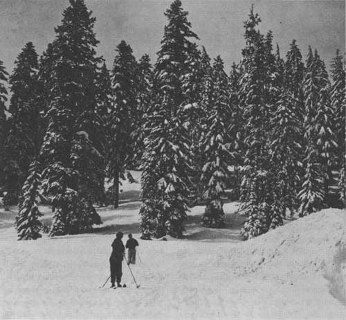
SKI SLOPES AND SNOW-COVERED TREES Photo by Rinehart
WINTER SPORTS
The park is open the year around. Visitors may now enjoy the scenic values of Crater Lake in winter as well as winter sports amid a phantasy of snowy splendor. Steep and gradual slopes, according to speeds desired, are numerous in the park and are ideal for skiing. Professional ski meets are not encouraged, but special attention is given to amateur sports.
The west and south entrance roads to the Rim Village area are open to motor travel. Chains, tow rope and shovel are necessary accessories to motor travel. Meals and limited overnight accommodations and emergency auto service are provided at park headquarters during the winter months. Warming room facilities are available at the Rim Village. Rangers are on duty to render service to visitors.
ADMINISTRATION AND PARK HEADQUARTERS
The park is administered by the National Park Service of the Department of the Interior. The superintendent, E. P. Leavitt, is in immediate charge, with offices in the administrative center, 3 miles from the Rim Village. The post office address is Crater Lake, Oreg. Long distance telephone and telegraph service is available at park headquarters.
RIM VILLAGE
In the Rim Village on the south side of the lake are the Lodge, rental cabins, cafeteria, store, emergency mechanical service, campground, community house, information building, and Sinnott Memorial. The lake is accessible by trail from the Rim Village. All guided trips start from the area.
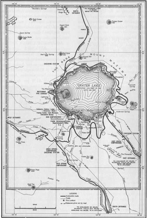
MAP OF CRATER LAKE NATIONAL PARK
(click on image for a PDF version)
ACCOMMODATIONS AND EXPENSES
The Crater Lake National Park Co. offers accommodations for park visitors. Rates for rooms at the Lodge range from $2.75 to $5.50 single and $3.25 to $7.50 double, European plan. American plan rates are $3.50 per day higher per person. Children under 8 years, half rates. Housekeeping cabins rent for $1.75 per day without linen and blankets, or $2.50 with bedding. Cafeteria and store facilities are available.
MOTOR TRANSPORTATION.—Daily automobile service from Medford and Klamath Falls to Crater Lake Lodge is maintained by the Crater Lake National Park Co. from July 1 to September 19. The round-trip cost is $8 per person and only round-trip tickets are sold. A visitor may enter by way of Medford and leave by way of Klamath Falls. The trip requires 2-1/2 hours from the latter place and 3 hours from the former.
LAUNCHES AND ROWBOATS.—Rowboats may be hired at 50 cents per hour. Scheduled trips are made daily by launch to the Phantom Ship and Wizard Island, about 15 miles, at a cost of $2 per person. Hourly trips are made to Wizard Island for $1 per person. Fishing tackle may be rented at the boat landing.
One of the popular attractions is a launch trip around the lake, leaving the boat landing at 9 o'clock each morning during the travel season. A ranger-naturalist describes to the launch passengers the points of scenic and scientific interest. The trip has been carefully planned and is available at the cost of $2 per person.
This booklet is issued once a year and the rates mentioned herein may have changed slightly since issuance, but the latest rates approved by the Secretary of the Interior are on file with the superintendent and park operator.
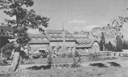
CRATER LAKE LODGE Aldrich photo
HOW TO REACH THE PARK
BY RAILROAD.—The Southern Pacific Railroad serves the park, rail heads being at Klamath Falls and Medford, Oreg. Crater Lake auto stages make connections daily at both cities from July 1 to September 19.
BY AUTOMOBILE. — Visitors have a choice of entering the park over paved State highways connecting with main north-south U. S. highways. From U. S. 101, 199, and 99 west of the park visitors enter over State highway 62, From U. S. 97 east of the park visitors may enter via State highways 62, through Fort Klamath, the south entrance; or 232, the east entrance; or 230 and 209, the north entrance, utilizing portions of the Rim Drive to reach the Rim Village. The west and south entrance roads are maintained as all-year roads, the north and east entrance roads including the Rim Drive being closed to traffic during the winter months.
By AIRPLANE.—The United Airlines serves Medford, the park's gateway city on the west.
BY MOTOR COACH.—Medford, Oreg., is served by Pacific Greyhound Lines, as is Klamath Falls, Oreg., from the south, and Mount Hood Stages from the north, via Bend. Transportation to the park from Klamath Falls and Medford is provided July 1 to September 19 by Crater Lake National Park Co. auto stages.
OREGON CAVES NATIONAL MONUMENT OREGON
Located 160 miles southwest of Crater Lake, Oregon Caves National Monument is one of the scenic attractions of southern Oregon, administered by the superintendent of Crater Lake National Park. The monument is in the heart of the Siskiyou Mountains and is easily accessible by paved, all-year highways.
The Caves, also known as "The Marble Halls of Oregon," offer visitors an opportunity to explore several miles of winding passageways and large rooms, which nature has decorated with fantastic formations, weird in their eerie beauty. Guide service through the electrically lighted caverns is available throughout the year.
In the 480 acres of the monument there are several miles of excellent trail affording visitors an opportunity to enjoy views of the mountains mantled with a virgin Douglas fir type forest and to Study the wildlife.
Lodging and meal service are available throughout the year at the well appointed Oregon Caves Chateau located near the entrance to the Caves. During the summer season park rangers and the crew at the Chateau present each evening a campfire program.
LAVA BEDS NATIONAL MONUMENT
CALIFORNIA
Located in northern California, 105 miles south of Crater Lake, the Lava Beds National Monument, administered by the Crater Lake National Park staff since 1933, covers an area of 45,967 acres, noteworthy for volcanic, historical, and archeological features of distinctive importance.
The monument is open to travel the entire year from points along the Klamath Falls, Oregon-Alturas, California Highway. Administrative headquarters of the monument are maintained at Indian Well, with a park ranger in charge. A small museum of old war relics and volcanic specimens is maintained here. A campground is nearby. No gasoline, food, or other accommodations are available in the monument, but these can be procured within 20 miles of the area at Merrill, Oreg., or Tule Lake, Calif.
The area includes a vast field for geologic study. During recent geologic time volcanic activity poured rivers of molten lava from numerous fissures and vents. Cinder cones rise above the fairly level terrain. There are scores of lava tubes or caves, some of which are open to visitors.
Within the monument are the important battlefields of the famous Modoc War of 1872-3. The Stronghold, a natural fortification in which about 60 Modoc warriors defended themselves against the attacks of nearly 1,000 U. S. troops, is an attraction of the monument.
At Petroglyph Point are numerous petroglyphs carved in rock, and in caves appear pictographs,—two types of the symbolic writing of prehistoric Indians.
During the winter and spring months, mule deer are seen in large numbers. Small mammals and numerous species of birds are common. The cliffs of Petroglyph Point offer an exceptional opportunity for the study of raptores. Along the north boundary of the monument thousands of water fowl may be seen feeding in the Tule Lake Bird Refuge.
INTERESTING BRIEFS OF CRATER LAKE NATIONAL PARK
Crater Lake was discovered June 12, 1853.
The area was established as a national park in 1902.
The lake has an area of 21 square miles, the crater 27 square miles.
The greatest diameter of the lake is 6 miles, the shoreline circumference being approximately 20 miles.
The lake, sounded in 1886, has a maximum depth of 1,996 feet.
Crater Lake is the deepest lake on the continent of North America and fourth deepest lake in the world.
The lake has no direct inlet and outlet, yet it is a body of fresh water.
The lake derives its water from snow and rain falling within the crater. Annual loss of water is by seepage and evaporation.
Average annual snowfall at Crater Lake is 53 feet, annual precipitation being 72 inches.
In 1932-33 annual snowfall was 73 feet.
Lake level varies 1 to 3 feet annually, being highest in spring, lowest in fall.
In 1939 lake level was approximately 6,164 feet above sea level.
Due to great depth and moderate winter temperatures the lake does not freeze.
Wizard Island rises 776 feet above the lake and covers approximately 1 sq. mi.
Hillman Peak, 8,156 feet, is highest point on crater rim, rising 1,992 feet above the lake.
Kerr Notch and Wineglass are low points on the rim, being slightly more than 500 feet above the lake.
The Lodge and Rim Village area are at an elevation of 7,100 feet, approximately 950 feet above the lake.
The lake was devoid of fish until 1888 when the first fish were planted. Fish are planted annually.
Over 570 species of ferns and flowering plants have been identified in the park.
The park's check-list of birds includes 115 species.
Large and small mammals found in the park include approximately 60 species.
Crater Lake National Park is an outstanding blend of scenic and scientific values.
The crater cupping the lake was probably formed within the past 5,000 years by the collapse of the peak of an ancient volcano.
RULES AND REGULATIONS
[Briefed]
THE PARK REGULATIONS are designed for the protection of the natural features and for the comfort and convenience of visitors. The following synopsis is for the guidance of visitors.
FIRES.—Light carefully and only in designated campgrounds. Extinguish completely before leaving camp, even for temporary absence. Do not guess your fire is out—know it.
CAMPS.—Use designated campgrounds. Keep the campgrounds clean. Combustible rubbish shall be burned on camp fires, and other refuse of all kinds shall be placed in garbage cans or pits provided for the purpose. Firewood is provided free of charge. Camping is restricted to 30 days.
TRASH.—Do not throw paper, lunch refuse, film cartons, chewing gum paper, or other trash over the rim, on walks, trails, roads, or elsewhere. Carry until you can burn in camp or place in receptacle.
TREES, FLOWERS, AND ANIMALS.—The destruction, injury, or disturbance in any way of the trees, flowers, birds, or animals is prohibited.
NOISES.—Be quiet in camp after others have gone to bed. Many people come here for rest.
AUTOMOBILES.—Careful driving is required at all times. Your car must be equipped with good brakes, horn, and lights. Passing on curves is prohibited. Obey traffic rules. A gasoline station is maintained on the main highway at park headquarters. The fee for automobile permit is $1.
DOGS.—Dogs are prohibited in the park overnight and are not permitted in the rim concentration area. When not in an automobile, dogs must be on a leash at all times.
WARNING ABOUT BEARS.—Do not feed, tease, or molest the bears. Bears will enter or break into automobiles if food that they can smell is left inside, They will also rob your camp of unprotected food supplies.
FISHING.—A limit of 12 fish per person per day has been set for lake angling. A catch of 20 fish is permitted in park streams. No fishing license is necessary.
PARK STAFF.—The staff is here to help and advise you. When in doubt ask a man in uniform. Men in uniform at the Information Bureau, park headquarters, and the several stations will be glad to help you plan your activity while in Crater Lake and to explain the regulations.
Complete rules and regulations are available at park headquarters.
| <<< Previous | <<< Contents>>> |
1940/crla/sec1.htm
Last Updated: 20-Jun-2010