|
GRAND CANYON
Guidebook 1941 |

|
THE DIVINE ABYSS
—John Burroughs
THE world's most wonderful spectacle, ever changing, alive with a million moods—that is the Grand Canyon.
It is a titanic gorge, 4 to 18 miles wide, 217 miles long, and a mile deep. At the bottom a mighty river, the Colorado, rushes toward the sea. Rising from its depths are whole ranges of mountains, reaching a mile toward the sky. Over the rock temples and into the depths of the chasm spreads a sea of seemingly unreal, constantly changing colors.
Watching from the South Rim in the early morning, when the light slants lengthwise from the Painted Desert, one sees the great capes of the opposite rim suddenly outlined in golden light against which their shapes loom in hazy blues. Down in the gorge, here and there, stretches of the Colorado River reflect the sunlight.
An hour later all is changed. The dark capes are brilliant-hued and well-defined. Scores of new temples have emerged from the purple gloom.
At midday the opposite walls have flattened and the capes and temples have lost their definite shadows. But as the afternoon wears on the spectacles of the morning creep back, now reversed and strangely altered in outline.
Just after sunset, the reds deepen to dim purples and the grays and yellows and greens change to magical blues.
Then night falls, and in the dark the Canyon suggests unimaginable mysteries. But should there be a moon, the outlines of the great abyss revive in silver light, a thousand spectral forms projected from inscrutable gloom.
The most picturesque section of the Grand Canyon, the first 105 miles west of Marble Canyon, is within the boundaries of Grand Canyon National Park. The park area is 1,008 square miles in extent. Beyond its eastern boundary lies the Painted Desert. Its western boundary includes Havasu Canyon, in whose depths live the Havasupai Indians. West of the park is Grand Canyon National Monument, which includes Toroweap Point, affording a remarkable view of the inner gorge of the Colorado River.
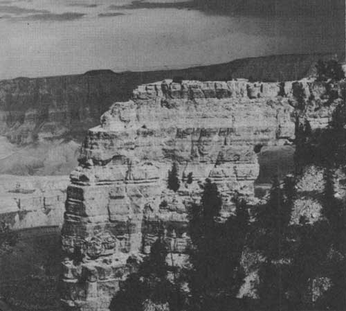
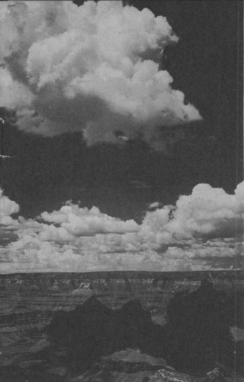 DRIFTING SHADOWS: SCURRYING, GROTESQUE FORMS ARE CAST UPON THE CANYON'S WALLS AND TEMPLES AS CLOUDS MOVE LAZILY ABOVE THE WIDE GORGE AND ITS MYRIAD CLIFFS, PEAKS, AND SPIRES |
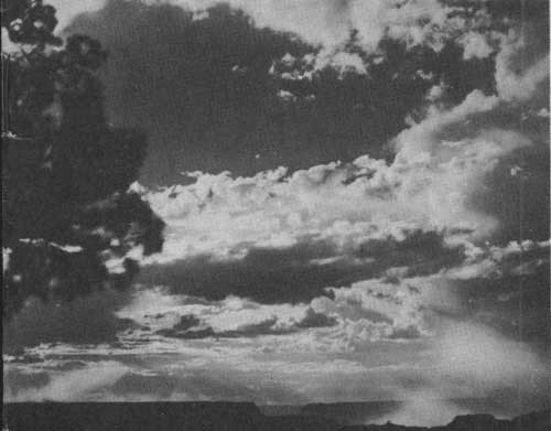 AFTER THE STORM: ACROSS THE CANYON RIMS AFTER A LATE AFTERNOON THUNDER SHOWER, WITH THE SUN'S RAYS BREAKING THROUGH THE CLOUDS, ILLUMINATING THE MISTS RISING FROM THE DEPTHS OF THE CHASM |
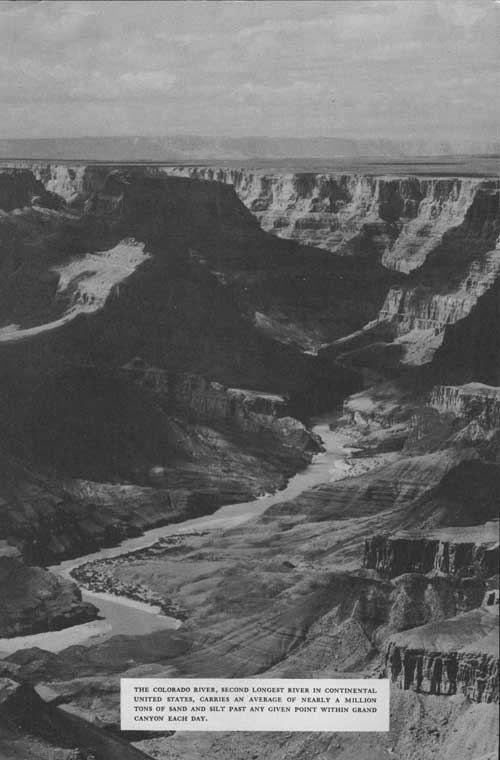 THE COLORADO RIVER, SECOND LONGEST RIVER IN CONTINENTAL UNITED STATES, CARRIES AN AVERAGE OF NEARLY A MILLION TONS OF SAND AND SILT PAST ANY GIVEN POINT WITHIN GRAND CANYON EACH DAY. |
UNTOLD AGES IN THE MAKING
THE story of the Grand Canyon is a story of hundreds of millions of years of earth making, a tale involving formation of high mountain ranges, the existence of great inland seas, and the tremendous erosive action of a turbulent river.
The beginning of the Grand Canyon history dates back to a time when, so far as is known, no life existed in the world. The flat-topped plateau of today did not exist then, but in its place was a great mountain mass which probably contained lofty snow-covered peaks similar to those seen in Rocky Mountain or Glacier National Parks.
After innumerable ages, these mountains were worn to a nearly level plain. This cycle of uplift and erosion was repeated and then the area, in common with most of North America, was flooded by the sea. The mud and sand which were washed into this sea slowly hardened to form the layers of rock which make up the upper gorge of the Canyon. Fossils of shells, corals, sponges, fishes, and similar marine forms are found in the rock walls and are evidence not only of the existence of these ancient seas but of the enormous passage of time since the first mountains, devoid of life, were worn away.
As time went on, the sea became shallow and tidal flats and sand beaches replaced the ocean depths. Tracks of the creatures which frequented the shore were impressed in the mud and have been preserved in the rocks formed from these sediments.
Finally, there occurred a slow arching of the earth's crust which raised the area several thousand feet above the sea and created the high plateau through which the Canyon was later cut. This Canyon is probably the world's most spectacular illustration of river erosion. The muddy waters of the Colorado River have cut a gorge 217 miles long and in some places over a mile in depth.
The work of cutting this tremendous chasm is not yet finished. The powerful forces of the rushing torrent, the intermittent rain and snow and frost are still at work deepening and widening this wonderful example of earth sculpture.
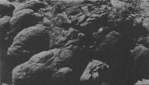
 LAYER UPON LAYER OF AGES-OLD ROCKS FROM THE WALLS AND CAPES OF GRAND CANYON. THEY DATE BACK TO THE OLDEST KNOWN GEOLOGICAL PERIOD |
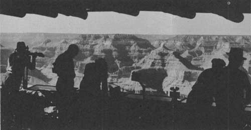 AT YAVAPAI OBSERVATION STATION AND MUSEUM THE STORY OF THE GRAND CANYON IS TOLD THROUGH A SERIES OF BINOCULARS FOCUSED UPON INTERESTING FEATURES BELOW. NO STAY ON THE SOUTH RIM OF THE PARK IS COMPLETE WITHOUT A VISIT TO THIS STATION WHERE TRAINED NATURALISTS TELL DAILY OF THE HISTORY AND ORIGIN OF THE CHASM. |
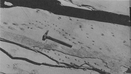
 PREHISTORIC FOOTPRINTS OF VERTEBRATE ANIMALS. PRINTS OF A LARGE MAMMAL OF A TYPE UNKNOWN TO THE WORLD TODAY |
 FOSSIL SPONGES DISCOVERED WITHIN THE CANYON, INDICATING THAT THE REGION AT ONE TIME WAS BENEATH THE SURFACE OF A VAST SALT SEA |
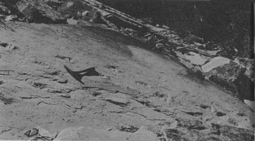
 FOSSIL FOOTPRINTS OF A LIZARD-LIKE ANIMAL THAT LIVED MILLIONS OF YEARS AGO |
ON THE SOUTH RIM
OPEN ALL YEAR
THERE is a pleasing air of western informality in the hotel, cabin, and camp life, and in the facilities for viewing the wonders of the Canyon. Costs are reasonable, prices ranging from $1.25 per day for an auto-camp cabin to $11.50 and up per day, American plan, for two persons in a room with bath at El Tovar Hotel.
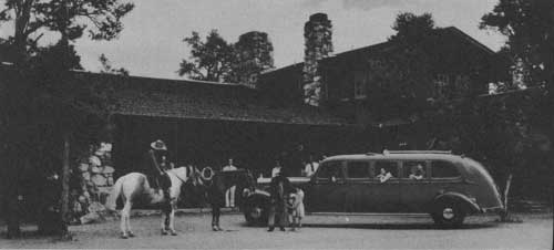
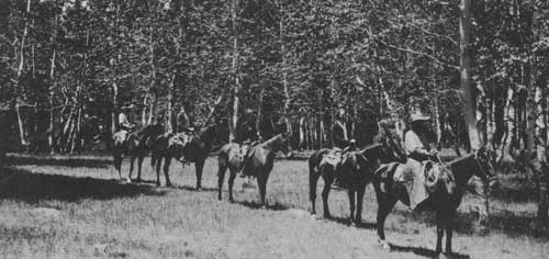
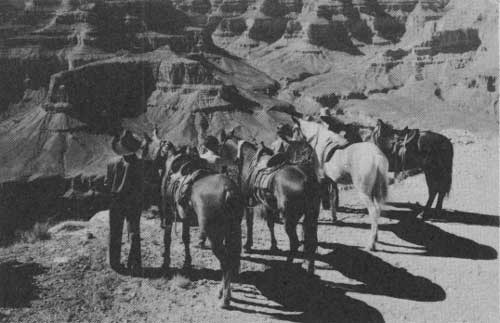 A HORSEBACK PARTY PAUSES ON THE CANYON RIM TO STUDY THE CONSTANTLY CHANGING SCENE BEFORE THEM. AN INTERESTING ONE-DAY TRIP IS MADE TO DRIPPING SPRINGS ON HORSEBACK. THE ROUTE FOLLOWS THE WEST RIM DRIVE, AND THE RETURN TRIP IS MADE THROUGH THE FOREST. |
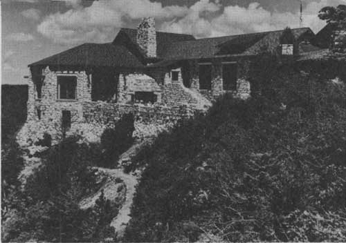
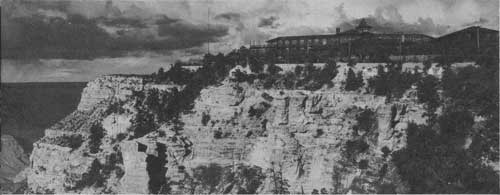 EL TOVAR HOTEL, SITUATED ON THE CANYON'S RIM. FOR A THIRD OF A CENTURY THIS PICTURESQUE, RAMBLING STRUCTURE HAS SERVED A COSMOPOLITAN AND DISTINGUISHED CLIENTELE |
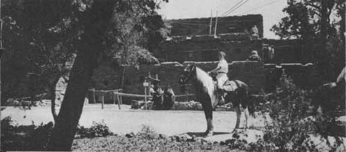 HOPI HOUSE, NEAR EL TOVAR AND BRIGHT ANGEL LODGE, GIVES VISITORS AN INTERESTING GLIMPSE OF NATIVE INDIAN LIFE. INDIAN HANDICRAFT IS SOLD HERE |
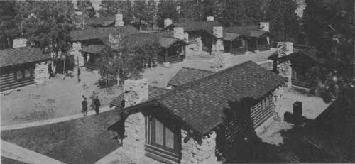
BRIGHT ANGEL LODGE AND CABINS
A CHARMING village of log, stone, and adobe on the South Rim of the Canyon. Living quarters are unpretentious, informal, and comfortable. Free public campgrounds are nearby.
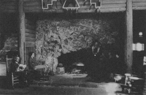 COMFORTABLE ACCOMMODATIONS FOR MORE THAN 200 PERSONS ARE AVAILABLE IN LODGES AND CABINS SURROUNDING THE CENTRAL BUILDING OF BRIGHT ANGEL LODGE. THE COFFEE SHOP IS WELL KNOWN IN THE SOUTHWEST FOR ITS EXCELLENT CUISINE. |
 BRIGHT ANGEL LODGE. |
 AT THE LODGE IN THE PUBLIC CAMPGROUNDS OVERNIGHT OR HOUSEKEEPING TYPE CABINS MAY BE RENTED. CAMPERS SUPPLIES, CURIOS, POST CARDS AND SOUVENIRS MAY BE PURCHASED. DURING THE SUMMER MONTHS AN ECONOMICAL CAFETERIA SERVICE IS PROVIDED. |
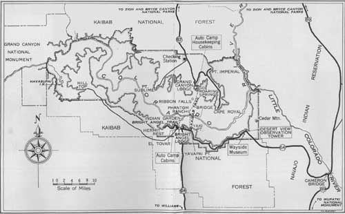 GRAND CANYON NATIONAL PARK, SHOWING APPROACH ROADS (click on image for a PDF version) |
ON THE NORTH RIM
SEASON IS FROM MAY 30 TO SEPTEMBER 30, INCLUSIVE
SOME of the most spectacular views of the Canyon are from the North Rim, about 1,200 feet higher than the South Rim.
The Lodge, de luxe and housekeeping cabins, and free public campgrounds afford picturesque living accommodations at a wide price range, from $2 per clay for cabins to $8.25 per day. European plan, for three in a de luxe sleeping cabin.
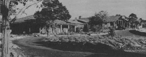
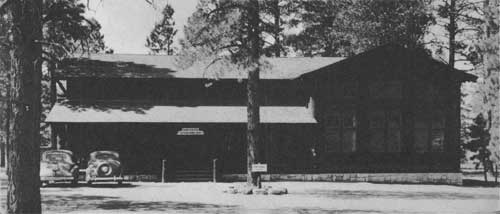
 GRAND CANYON LODGE ON BRIGHT ANGEL POINT, COMMANDS SUPERB VIEWS OF GRAND CANYON. ALL MODERN HOTEL FACILITIES ARE PROVIDED, WITH SLEEPING CABINS GROUPED AMONG THE TREES. |
 CABINS SURROUND THE LODGE ON THE NORTH RIM, PROVIDING COMFORTABLE AND UNIQUE SLEEPING QUARTERS, WITH OR WITHOUT BATH; SOME HAVE STONE FIREPLACES; ALL ARE UNUSUALLY ATTRACTIVE |
 AUTO-CAMP CABINS, SOME EQUIPPED FOR HOUSEKEEPING, SURROUND A STORE AND CAFETERIA BUILDING |
AROUND THE RIMS
THE immensity of the Canyon can best be realized by drives along the Rims. From Grand Canyon Village fine roads lead to Hermit Rest and Desert View. On the North Rim automobile trips to Point Imperial and Cape Royal and to Point Sublime reward visitors with unsurpassed views.
Modern, comfortable motorbuses are available to take visitors along the rim drives on regularly scheduled trips and to the surrounding country.
Ranger naturalists explain the story of Grand Canyon to groups and daily lead a caravan of motorists driving their own cars.
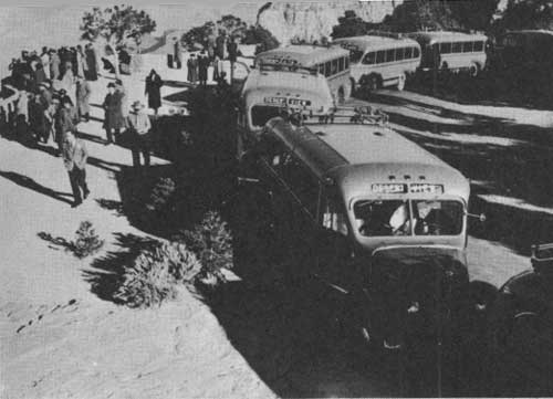 BUSES STOP AT YAVAPAI POINT TO LET VISITORS VIEW THE ENORMOUS ABYSS |
 PART OF THE TRAIL IS IN SYLVAN SETTING |
 ANGELS WINDOW ON THE NORTH RIM OFFERS A SUPERB VIEW OF THE GRAND CANYON |
DOWN THE TRAIL
No trip to Grand Canyon is complete without a journey to the bottom of the gorge. Down Bright Angel or Kaibab Trail, leading to the turbulent Colorado River, are the famous suspension bridge, beautiful waterfalls in the side canyons, and Phantom Ranch.
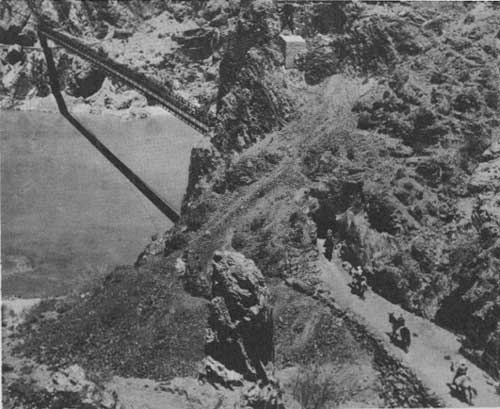 PARTIES OF PARK VISITORS MAKING THE 2 TO 3-DAY MULE-BACK TRIPS INTO GRAND CANYON CROSS THE KAIBAB SUSPENSION BRIDGE TO REACH PHANTOM RANCH, WHERE COMFORTABLE OVERNIGHT ACCOMMODATIONS ARE AVAILABLE. |
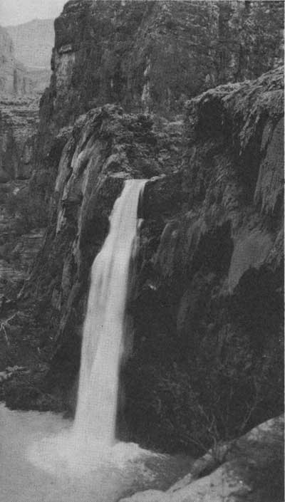 HAVASU FALLS IN HAVASU CANYON |
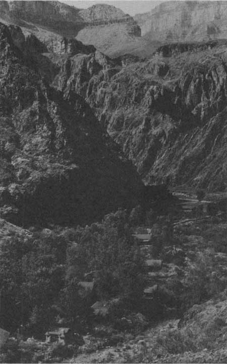 PHANTOM RANCH, NESTLED IN THE DEPTHS OF THE INNER GORGE OF THE CANYON BESIDE CRYSTAL CLEAR BRIGHT ANGEL CREEK, OFFERS VISITORS EVERY MODERN CONVENIENCE, TROUT FISHERMEN MAKE THIS THEIR HEADQUARTERS WHEN TRYING THEIR LUCK IN THE WELL-STOCKED CREEK. |
FLORA AND FAUNA OF THE CANYON
THE Grand Canyon region has a wide range of plant and animal life. On the North Rim is the Kaibab squirrel, found nowhere else in the world, and on the South Rim the Abert squirrel. In addition, there are mule deer, mountain sheep, antelope, and other animals. Around the rim and within the Canyon are many varieties of wildflowers. Forests of aspen, spruce, pine, and other trees are adjacent to the park and within its borders on the rims.
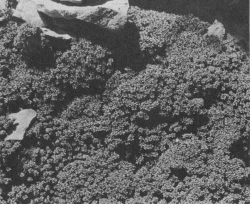 MASS OF ROCK ROSES ON THE NORTH SIDE OF THE CANYON ABOVE ROARING SPRINGS |
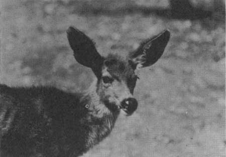 MULE DEER ON THE SOUTH RIM. THEY ALSO ARE FOUND ON THE SOUTH RIM, WHERE THEY WERE TRANSPORTED FROM THE NORTH RIM BY AIRPLANE AND AUTO-TRUCK. |
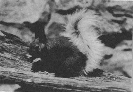 KAIBAB SQUIRREL, A SPECIES FOUND ONLY ON THE NORTH RIM |
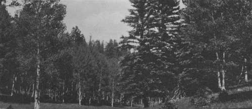 STATELY TREES. QUAKING ASPEN, WHITE FIR, AND SPRUCE ON THE NORTH RIM OF THE CANYON. |
THE REGION ROUND-ABOUT
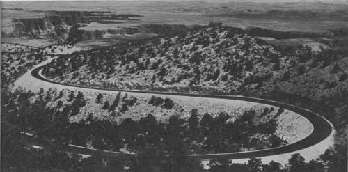 NAVAHOPI ROAD, WINDING THROUGH THE PAINTED DESERT AND LEADING TO THE NAVAJO AND HOPI INDIAN COUNTRY AND THE MANY POINTS OF INTEREST EAST AND NORTH OF THE GRAND CANYON. THIS ROAD CONNECTS WITH HIGHWAYS LEADING TO THE NORTH RIM. ON THE NORTH RIM IS THE KAIBAB NATIONAL FOREST, WITH ITS WILDLIFE AND NUMEROUS BRIDLE PATHS |
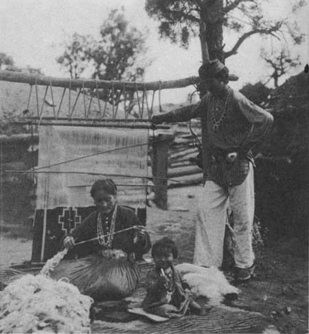 THE INDIAN FAMILY ON THE NAVAJO INDIAN RESERVATION EAST OF THE CANYON. NAVAJO WOMAN SHOWN SPINNING WOOL FOR BLANKET |
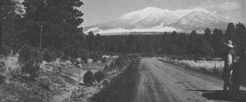 SAN FRANCISCO PEAKS ARE VISIBLE FROM THE GRAND CANYON AND MAY BE SEEN FROM THE DESERT VIEW DRIVE |
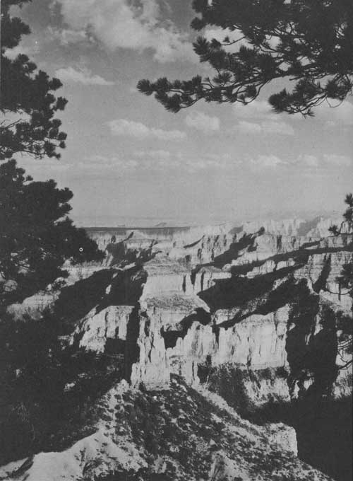 GRAND CANYON FROM POINT IMPERIAL |
How to get to GRAND CANYON NATIONAL PARKS
BY AUTOMOBILES
TO SOUTH RIM.—State Route 64 leads from U. S. Highway 66, main east and west highway through northern Arizona, to park headquarters at Grand Canyon Village. The Navahopi Road, recently constructed from Desert View, east entrance to the park, connects with U. S. Highway 89 a mile and a half south of Cameron, Ariz. U. S. Highways 66 and 89 connect Cameron and Flagstaff, Ariz. These roads are open all year.
TO NORTH RIM.—From Cedar City, Utah, U. S. Highway 91 leads to Zion National Park. From Zion a new road extends via Pine Creek to Mount Carmel, passing through a mile of tunnels in Zion Canyon, and connecting at Mount Carmel with U. S. Highway 89 extending northward toward Bryce Canyon National Park and southward via Kanab, Utah, and Fredonia, Ariz., to the Grand Canyon. Another good road from Cedar City leads over Cedar Mountain via Cedar Breaks to Cedar Junction and the Grand Canyon rim. Roads to the North Rim are closed from October 15 to May 15.
BY AIRPLANE
TO SOUTH RIM.—Transcontinental and Western Air (TWA) routes its daylight flights over Grand Canyon, and the Grand Canyon Airport is a flag stop for certain of these flights. United Air Lines and Western Air Express deliver passengers at Las Vegas, Nev., American Airlines at Phoenix, Ariz., TWA at Winslow, Ariz., from where the trip to the park is made by charter arrangements with Grand Canyon Airlines. Grand Canyon Air lines maintains an airport approximately 18 miles from the South Rim. Hangar space and service for visiting planes are available.
TO NORTH RIM.—The North Rim landing field is located at De Motte Park (VT), 18 miles from Grand Canyon Lodge. From this airport scheduled trans-Canyon service is maintained throughout the summer season by Grand Canyon Airlines.
BY RAILROAD
TO SOUTH RIM.—A branch line of the Atchison, Topeka & Santa Fe Railway runs from Williams, Ariz., direct to the park. On certain trains, through Pullmans are operated directly to Grand Canyon. For other trains regular and frequent motor-Stage service is maintained between Williams and Grand Canyon.
TO NORTH RIM.—The Union Pacific System delivers its passengers at Cedar City, from where the Utah Parks Co. operates regular motor-Stage service to the Canyon's North Rim. Visitors to the Grand Canyon from either of these Utah points may make an interesting trip covering Bryce Canyon National Park, Cedar Breaks National Monument, and Zion National Park.
BY BUS
TO SOUTH RIM.—Transcontinental buses of the Pacific Greyhound Lines and the Santa Fe Trails System go to both Flagstaff and Williams, Ariz. The Navahopi Tours operates between Flagstaff and the south entrance to the park. The Fred Harvey Line has service between Williams and the park.
TO NORTH RIM.—The Burlington Transportation Co. and the Interstate Transit Lines serve Cedar City from Salt Lake City and Los Angeles. In addition, the Santa Fe Trails System delivers passengers from Salt Lake City at Jacob Lake, Ariz., where transportation to the park is available. The Utah Parks Co. buses provide service from Cedar City to the park.
FOR FURTHER INFORMATION
Any travel bureau, railroad, bus line, airline ticket office, or local automobile club can furnish information concerning Grand Canyon National Park. Write to the Superintendent, Grand Canyon National Park, Grand Canyon, Ariz., or the Director, National Park Service, United States Department of the Interior, Washington, D. C., for detailed information.
| <<< Previous | <<< Contents>>> |
1941/grca/sec1.htm
Last Updated: 20-Jun-2010