|
WIND CAVE
Circular of General Information 1936 |

|
WIND CAVE
National Park
• OPEN ALL YEAR •
THE BLACK HILLS REGION OF SOUTH DAKOTA, in which Wind Cave National Park is located, has a fascinating story of earth making to tell. It ranges in interest from ancient fossil deposits buried in the Badlands telling a tale of prehistoric alligators, rhinoceroses, three-toed horses, and other long-extinct animals, to the lofty "needle" formations, which. erosion has sculptured from masses of granite high up the forest-clad slopes of the Black Hills.
Wind Cave lies in the great Pahasapa limestone formation which also contains several other large subterranean caverns. The facts about the discovery of the cave are little known, but it is generally believed that it was discovered by Tom Bingham, a Black Hills pioneer, while hunting deer in 1881. He was attracted by a strange whistling and after searching about in the undergrowth, he discovered that it was caused by wind escaping through a small hole in some rocks. This hole, not more than 10 inches in diameter, is the only natural opening to the cave so far discovered. It is located a few steps behind the present cave entrance.
The strong currents of wind that blow alternately in and out of the mouth of the cave suggested its name. This strange phenomenon is believed to be caused by changes in the atmospheric pressure outside. When the barometer is falling, the wind usually blows outward; when it rises, the wind blows in. Many visitors enjoy stopping at the cave entrance to post themselves on weather indications.
The present cavern opening was made by digging down about 6 feet to a long, winding fissure, or tunnel, leading into corridors and galleries decorated with a variety of crystal formations. These formations differ radically from those found in most caverns because stalactites and stalagmites are practically nonexistent in this cave, a feature that adds to its unique interest. Here the formations are of the unusual boxwork and frostwork type. The boxwork is composed of delicately colored crystals arranged in honeycomb pattern. Tiny white crystals, sometimes superimposed on a pink background, hang in clusters from ceilings and ledges to form a frostwork decoration of rare beauty. The cavern is approximately 10 miles in extent but has not been fully explored.
Wind Cave National Park was created by Act of Congress, dated January 9, 1903. Its boundaries were subsequently extended, and it now includes an area of 11,818.94 acres, part of which is used as a game preserve. Buffalo, elk, antelope, and deer range the preserve and are frequently seen from the main highway.

The characteristic boxwork formations have not been found elsewhere in
the United States. Stevens studio photo.
COLORFUL HISTORY
In addition to its natural beauty and scientific interest, the southwestern section of South Dakota has a colorful and picturesque history. Possibly a French explorer made his way into it as early as 1683, and the Verendrye brothers are said to have visited it in 1743.
The Sioux Indians, a tribe conspicuous even among Indians for strength and bravery, long occupied the region and only submitted to white settlement after a bitter and tragic struggle. This tribe is believed to have originated east of the Alleghenies, but as early as 1632 the French found them in Wisconsin and Minnesota. Some of their descendants are today living on the Pine Ridge and Rosebud Indian Reservations, a short drive from Wind Cave Park.
The war clouds that ended in the conflict of 1861-65 and Indian uprisings under the leadership of Red Cloud, Sitting Bull, Spotted Tail, and other great warriors hampered the development of this region, but in 1874 an expedition through the Black Hills led by Gen. George A. Custer resulted in the discovery of gold on French Creek and settlement followed rapidly. From 1879 to 1886 were boom days that made legendary figures of such pioneer characters as Wild Bill Hickok, Deadwood Dick, Calamity Jane, and Preacher Smith. The last-named three are buried in Deadwood.
Long before the Black Hills were well known for the scenic beauty that resulted in the establishment of Custer State Park in the heart of this rugged region and construction was begun on the Rushmore Memorial, the region was famous throughout the world for its mineral wealth, especially gold. The Homestake Mine at Lead is the largest gold mine in the United States. In 1933 almost one-fourth of the gold production of the United States came from the Black Hills. Since production began in 1875, gold totaling approximately $300,000,000 in value has been mined in this region. Some of the other minerals found in the region of economic value are silver, lead, copper, iron, tin, and tungsten ores; columbite, tantalite, mica, arsenic, lithia, and cesium minerals; fuller's earth, bentonite, volcanic ash, coal, petroleum, and structural materials.
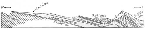
Section across the east slope of the Black Hills uplift through Wind
Cave looking north.
GEOLOGICAL HISTORY OF WIND CAVE
Caves, in general, may be classified in three divisions, according to the kind of rock in which they have developed. They may be formed in limestone, in igneous rocks, or in sandstone. Of these, limestone caves are the most important and most frequently attain great size. Wind Cave is a limestone cavern.
The limestone layer in which Wind Cave is formed varies in thickness in the Black Hills region from 300 to 630 feet. It is known as the Pahasapa limestone, a local formation of Mississippian age deposited in a great inland sea some 300 million years ago. Following the deposition of this limestone, it was elevated above the sea. Several such periods of elevation and subsidence occurred during geologic history. During these periods of submergence, the Pahasapa limestone was overlain by other sediments several hundred feet in thickness. The final upthrust of the land probably occurred during the later part of the Cretaceous period, some 60 million years ago. The beginning of the formation of Wind Cave probably dates from that time.
Limestone which has been subjected to several such periods of uplift or warping becomes fractured or broken. These cracks develop in all directions and at all angles. Those close together served as the pattern for the characteristic "boxwork", formed in the following manner: Rain water seeping down from the surface through decaying vegetation absorbed carbon dioxide, which renders the water more soluble for limestone. This carbon dioxide-bearing water takes some of the limestone into solution, then upon evaporation deposits it in the cracks or crevices below. Later the more soluble limestone between the fins of boxwork was dissolved away, leaving the boxwork formation as it is seen today.
Stalactites and stalagmites are common formations in most limestone caves, but these are rarely found in Wind Cave. The boxwork formations which predominate throughout the cave have not been found elsewhere in the United States.

Some of the delicate formations have a pink background. Stevens studio
photo.
WILDLIFE
With the transfer of the Wind Cave National Game Preserve from the custody of the United States Biological Survey to the National Park Service, effective July 1, 1935, opportunity was presented for adding a novel attraction to Wind Cave National Park. In anticipation of this transfer plans had already been formulated by which the herd of bison could be displayed, for the benefit of the public, and as nearly as possible in their natural state.
The animals were induced by the use of salt to frequent that part of the range close to the road and near enough to the administration building to enable those waiting to take trips through the caves to have a closer view of the animals. Fences which previously had impaired the effect of a natural habitat have now been removed. Motorists, who care to do so, may ride out on the range among the bison. It is not wise, however, to get out of the car inasmuch as the animals are not accustomed to close proximity to human beings.
Now that the fences have been removed antelopes also frequently come into sight along the picturesque, winding roads.
Cattle guards, at intervals, prevent the wildlife from straying from their reservation.
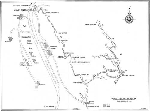
UNDERGROUND SURVEY, WIND CAVE NATIONAL PARK
(click on image for a PDF version)
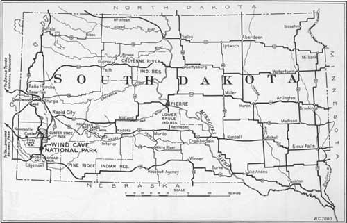
Main highways to Wind Cave National Park.
(click on image for a PDF version)
GENERAL INFORMATION
Wind Cave National Park is administered by the National Park Service of the Department of the Interior, and the representative of this bureau in charge of the park is Edward D. Freeland, superintendent. His address is Hot Springs, S. Dak.
CAVE TRIP
All trips through the cave are under the guidance of competent park rangers. The cave entrance fee is 50 cents. Children 16 years of age and under are admitted free of charge. The shorter route through the cavern requires approximately 2 hours and the longer one about 3 hours.
The trip through the cave is not unlike the average hike over a mountain trail. Comfortable walking shoes should be worn. The temperature is 47°, and does not vary winter or summer. It is advisable to take a light sweater or jacket. The cave was electrically lighted in 1931.
ELEVATOR SERVICE
During the year 1935 an elevator was installed in the cave for the convenience of the public. This saves one the necessity of climbing out of the cave. A nominal fee is charged each adult for this service.
SPECIMEN DISPLAYS
Display specimens of formations from the cave are kept in the headquarters building for study purposes and general inspection by the public. The handling of formations in the cave or the collection of souvenirs is strictly prohibited.
During the summer a wild-flower display is also maintained. It includes all the common species of Black Hills flora for the locality. Flower picking in the park without permission of the superintendent is strictly forbidden.
ACCOMMODATIONS
No hotels or tourist cabins are located in the park, but a public camp ground with free wood and water is maintained near headquarters. Lunchroom facilities and soda-fountain service are provided. Campers supplies, curios, and miscellaneous articles are obtainable.
Hot Springs is the southern entrance to the Black Hills. It is 10 miles south of Wind Cave National Park on United States Highway No. 85E. It is the post office for the park and has good hotels, camps, and garages. Hot Springs has a national sanatorium and State soldiers' home and is known as the picture town of the Black Hills.
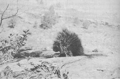
The shrublike object in the foreground is a porcupine. Stevens studio
photo.
RAILROADS
The park is readily accessible from the following railroad stations: Hot Springs, on the Chicago, Burlington & Quincy and the Chicago & North Western Railroads; Pringle and Custer, on the Chicago, Burlington & Quincy Railroad; and Buffalo Gap, on the Chicago & North Western. Hot Springs is an overnight ride from Sioux City, Omaha, Denver, and Billings. During the summer season round-trip excursion tickets are sold at reduced fares from the Middle West, East, and South to Hot Springs. Choice of routes in each direction is usually offered. Return routes are available, enabling passengers to make circuit trips with stop-over privileges. Passengers wishing to visit Wind Cave National Park as a side trip from Edgemont or Buffalo Gap (28 and 14 miles, respectively, from Hot Springs) may stop over on excursion tickets. From many eastern points, tickets to Yellowstone or Glacier National Parks are good for passage through Edgemont.
HIGHWAYS
Wind Cave National Park is on the Atlantic-Yellowstone-Pacific Highway and can be reached by side trip from either the Custer Battlefield route or the Black and Yellow Trail at Rapid City. This side trip also includes the Custer State Park and the Deadwood region. Wind Cave may also be reached from the Park-to-Park Highway by a side trip from Cheyenne or Orin, Wyo.
AIR SERVICE
High-speed de luxe airplane service from all points to Cheyenne is available through United Air Lines. Wyoming Air Service, operating from Pueblo, Colo., to Billings, Mont., also stops at Cheyenne. For persons of limited time this service offers a splendid opportunity to visit this park.
NEARBY ATTRACTIONS
Rangers at the park information desk will assist in planning a trip through the Black Hills and also give information about other national parks. In a trip of about 300 miles many interesting reservations, including Devils Tower, Jewel Cave, and Fossil Cycad National Monuments, the proposed Bad Lands National Monument, Custer State Park, two national forests, a fish hatchery, a bird refuge, and a reclamation project may be visited.
Jewel Cave National Monument, transferred to the National Park Service from the Forest Service by Executive order of the President on Apr. 1, 1934, is open to the public during June, July, and August. It is 14 miles west of Custer on Highway No. 36. The cave is a series of passages and small rooms, the walls of which are lined with calcite crystals.
Fossil Cycad National Monument, created in 1922 to preserve large deposits of fossil remains of fernlike plants that grew many million years ago in the Mesozoic period, is located in the southern edge of the Black Hills, a short distance from Wind Cave.
Proposed Bad Lands National Monument.—In sharp contrast to the verdant Black Hills country are the White River Badlands, a barren, treeless region a short distance to the southeast of Wind Cave. Here nature has beautified the earth with all shades of buff, cream, pale green, gold, and rose. Fantastically carved erosion forms rise above the valleys, some of them 150 to 300 feet high. The constantly shifting color and the weird formations make this a region of strong imaginative appeal.
Devils Tower National Monument.—Another unusual natural phenomenon of the Black Hills country is the Devils Tower across the State line in Wyoming. This is a great mass of igneous rock towering 600 feet above the Belle Fourche River.
GLOSSARY
A brief description of the technical terms used in this booklet and by rangers guiding visitors through the cave:
Aragonite (41).—A mineral form of calcium carbonate (CaCO3) white or tinted which frequently occurs as compound or radiating groups of crystals.
Boxwork (31).—The unique honeycomb formation of Wind Cave, compound of calcite with small amounts of hematite.
Calcite (31).—A mineral composed of calcium carbonate, which effervesces in acid. Often appears as frostwork in caves.
Chert (71).—A very hard, amorphous form of silica which is frequently found associated with limestone. In Wind Cave the chert is fossil bearing.
Concretion.—A rounded aggregate of mineral matter formed by precipitation or deposition around some nucleus (not a cave formation).
Conglomerate.—A sedimentary rock composed mainly of cemented, rounded gravel.
Cretaceous.—The last period of the Mesozoic era.
Dripstone (31).—Irregularly shaped deposits of calcium carbonate which is precipitated from evaporating water that seeps through the walls of a cave; stalactites and stalagmites are sometimes called dripstone.
Era.—A major division of recorded geological time.
Fault.—A dislocation or movement in rock masses along a plane of fracture.
Flowstone (31).—CaCO3 deposits formed by deposition from trickling or flowing water chiefly over walls.
Fossil.—Remains or traces of ancient animals or plants preserved in sedimentary rock, such as shells or tracks of animals or birds.
Frostwork (31).—A delicate aggregate of calcite crystals resembling frost; generally pure white.
Igneous rocks.—Rocks which have been formed by the cooling and hardening of molten rock material.
Limestone (41).—A sedimentary rock composed principally of calcium carbonate. It may be produced by the action of algae and invertebrates or by the precipitation of calcium carbonate from water.
Mississippian.—A period of the Paleozoic era.
Outcrop.—An exposure of rock at the surface.
Paleozoic.—The third great era of recorded geological time. The time of great development of invertebrates, fish, and fernlike trees. The era is subdivided commonly into seven periods: Cambrian (oldest), Ordovician, Silurian, Devonian, Mississippian, Pennsylvanian, and Permian.
Stalactites.—Calcareous cylinders or cones that hang from the roofs of limestone caves and are formed from the lime-bearing waters that seep through the roof.
Stalagmites.—Structures similar to stalactites which develop on the floor of limestone caves and grow upward by additions from water dripping upon them from the ceiling of the cave. Usually more blunt than stalactites.
Travertine (31).—Calcium carbonate (CaCO3) deposited from solution by springs or running water. Embraces many types of deposition.
1Scale of hardness of minerals.
1-Talc 3-Calcite 5-Apatite 7-Quartz 9-Corundum
2-Gypsum 4-Fluorite 6-Orthoclase 8-Topaz 10-Diamond
|
Glimpses of Our National Parks. Brief descriptions of national parks. Address Director, National Park Service, Washington, D. C. Free. Recreational Map. Shows Federal and State reservations with recreational opportunities. Brief descriptions of principal ones. Free. Fauna of the National Parks. Series No. 1. By G. M. Wright, J. S. Dixon, and B. H. Thompson. Survey of wildlife conditions in the national parks. Illustrated. 157 pages. Superintendent of Documents, Washington, D. C. 20 cents. Fauna of the National Parks. Series No. 2. Wildlife management in the national parks. By G. M. Wright and B. H. Thompson. Illustrated. 142 pages. Superintendent of Documents, Washington, D. C. 20 cents. National Parks Portfolio. By Robert Sterling Yard. Cloth-bound and illustrated with more than 300 beautiful photographs of the national parks. Superintendent of Documents, Washing ton, D. C. $1.50. Booklets about each of the national parks listed below may be obtained free of charge by writing the Director, National Park Service, Washington, D. C.:
|
| <<< Previous | <<< Contents>>> |
1936/wica/sec2.htm
Last Updated: 20-Jun-2010