CELEBRATING THE NATIONAL PARK SERVICE CENTENNIAL • 1916-2016

White Sands National Monument
NPS Centennial Monthly Feature
For this month's reflection back on the first 100 years of the
National Park Service, we'll explore one more important period during
NPS history — the largest expansion of the National Park System
since its founding resulting from the passage of the Alaska National Interest
Lands Conservation Act (ANILCA) in 1980. Over a dozen national park
units, encompassing over 157,000,000 acres were added to the
System. "Do Things Right the First Time" Administrative History: The National Park Service and the Alaska National Interest Lands Conservation Act of 1980 G. Frank Williss Foreword Passage of the Alaska Lands Act of 1980 marked the historic zenith of this Nation's conservation and national parks movement. On a grand scale, with now-or-never urgency, the people, their agency trustees, and their elected representatives fulminated over Alaska's fate, striving to balance conflicting demands of preservation and development. The struggle became a symbol of paramount national values, transcending the Alaska land base itself. Only by the thinnest margin of time and events was the Act consummated, for the trends of world history now thrust us apace into the economy of scarcity. No matter how many new parks and refuges may be enacted in the years to come, never again will such extensive landscapes be dedicated to esthetic, essentially non-utilitarian futures. Over many generations the Nation's conservation systems had preserved scattered remnants of the frontier in the developed regions of the country. Alaska—its remote spaces thinly populated by people who left few traces—allowed an accelerated but more generous replay of that earlier history "down below." The forces that took a century to fence the trans-Mississippi West were similarly transforming Alaska in little more than a decade. Statehood, Native land claims, and oil combined to impose a new land tenure system on one-fifth of the Nation in record time. At some point in this gigantic land disposition the national interest must be served. In 1971 Congress set in motion the process that would allot Alaska's land amongst its many claimants, changing Alaska from almost wholly federal domain to a mix of federal, state, and private ownerships. As part of this process, the National Park Service and other federal conservation agencies were to recommend national interest lands, which Congress would consider for preservation as parks, forests, wildlife refuges, and wild rivers. This mandate triggered a massive response by the agencies, by conservationists, by opponents of the conservation proposals, and by Congress itself. Nine years it took, from 1971 to 1980, to resolve by legislation the issues raised by the national interest lands commandment. The course of events during that nine years, as it affected and was affected by the National Park Service, is the subject of this study. Though the work of other agencies and groups is treated for contextual purposes, the substance of this study is the institutional response of the National Park Service to the congressional charge. Nor is this study designed to assign credit internally or to other agencies and groups for the roles, actions, and decisions that helped to carry the legislative and political process to conclusion. Rather, it is an institutional history premised on the notions that all of the players inside and outside the National Park Service did their work according to the lights that guided them, and that given the stakes of land and the varied interpretations of the national interest residing therein, the eventual political settlement embodied by the Act gives proof of the vitality of the democratic process in this Nation. It is recognized that this study verges on instant history. In this instance, the justification for writing history while the wake of events still perturbs the waters is twofold: First, in minds and files, all of them mortal or destructible, lie the data of history. These data erode as people scatter and the years take toll of lives and records. Second, the evolution of the parkland proposals during the legislative and political process largely defined congressional intent and prescribed the tone for parkland administration, intent and tone that would carefully blend national, state, and local interests in varying combinations in each of the parklands. In his December 2, 1980, directive for implementation of the Act to his assistant secretaries, Secretary of the Interior Cecil Andrus put the case succinctly:
In this light, the present study is a facet of the implementation of the Alaska Lands Act of 1980. It is principally an overview historical narrative that isolates salient events and actions. Secondarily, it is the means to identify, compile, and protect (physically or by reference to source repositories) the documents and, by extensive taped interviews, the memories of participants. The study is not intended as the definitive word on all aspects of National Park Service involvement in the Alaska Lands Act process. Rather, it provides the narrative frame for major events and compiles the data for future detailed studies, as these are deemed necessary and appropriate by historians both inside and outside the National Park Service. This study contributes to the larger history of the Alaska Lands Act being compiled by other federal and state agencies, public groups, and congressional bodies. Someday, perhaps, these many elements will be synthesized in a general history. As important, as Secretary Andrus recognized, this history will illuminate the Alaska management policies of the National Park Service itself. Captured in the narrative and the reference annotations are the base points of congressional intent and understanding as to the roles and functions of each parkland in the Alaska mosaic These distillations of purpose help hold Park Service administrators to account. Ignorance of these purposes could produce drift and deviation from ideas and ideals forged by nine hard years of thought, strife, and resolution. The point is, each of these new parklands has a defining history already. This history, pulled together and recounted in this volume, is a guide to parkland administration. Here are explicated the sanctions of a law that finally balanced conflicting interests through democratic process. Thus, though people change, this history, if assiduously consulted, can lend continuity of administration to a land base that requires new departures and adaptations by the National Park Service. The rationale for non-traditional parkland management—in such critical fields as access, hunting and subsistence, wilderness, habitat, and cultural protection—are here set forth. Any responsible National Park Service official dealing with Alaska lands or issues—whether in administrative management, planning, development, or operations—who remains ignorant of this complex background imperils the future of the Alaska parklands. The author of this work, Historian Frank Williss, has set the Alaska Lands Act-period into a contextual history significant in its own right. Chapter One traces the earlier history of the National Parks in Alaska, beginning in 1910. The traditions established in those pioneering years lent substance to a long series of critical land-use, biological, and cultural studies that laid the groundwork for National Park proposals in the 1970s. Chapter Two establishes the background of the Alaska Native Claims Settlement Act of 1971, one clause of which called for conservation-unit proposals to be presented to Congress. Chapter Three relates the internal response of the National Park Service to this call, the mobilization of the Alaska Planning Group, and the inter-agency cooperation that resulted in the 1973 proposals to Congress. Chapter Four describes the legislative process that then ensued, a process that evolved over six years into a hard-fought political struggle that taxed the National Park Service to provide specific data and revised recommendations relating to the proposed parklands. Chapter Five narrates the ground-proofing work of the Alaska-based task force, in social and physical environments that required tenacity and enlarged perspective. Here, too, is treated the controversial National Monuments period, 1978-80, a time when a necessary holding action at the national level created great stress in Alaska at the community level, pending confirming action by Congress. Finally, the Epilogue treats the first stages of Alaska Lands Act implementation, a challenging period when non-traditional parkland precedents were set by a gifted group of superintendents and their miniscule staffs, who were thrust into vast landscapes with only the slimmest resources. Mr. Williss concludes his history with questions about a future unpredictable but promising. With a personal note I conclude this Introduction. To have participated in some of the exciting moments of this history—with the talented and dedicated people whose work is sketched below—was to touch the stuff of legend. There was drama here, every bit as moving as that passed down from the legendary campfire at Yellowstone. But all this was only prelude. The work now being done and yet to do gives us the chance to recapitulate the early days of Park Service history. Here is a place where new legends wait to be born, where new heroes can prove their mettle. William E. Brown Preface The Alaska National Interest Lands Conservation Act of 1980 (ANILCA) was one of the most significant pieces of conservation legislation in this Nation's history. The nine-year struggle over the disposition of the public lands in Alaska is, moreover, a fascinating case study in the American democratic process, where differing views over the uses of those lands would be presented, argued, and, finally compromised. Not the least of the complex of forces involved in the process was the role of the Federal agencies. In the unfolding drama, these agencies had to respond to congressional mandates, the demands of the conservation community, and pro-development pressures. The purpose of this paper is to examine the history of the National Park Service in Alaska, and in the legislative process that resulted in ANILCA. The study is not a general history of ANILCA. Rather, it is a one-sided one that examines the role of one agency whose primary mission is preservation. It is not, moreover, intended to be definitive history of the Park Service's role. It is the first step in an analysis of the Service's role in the process, and is part of the on-going effort to implement the ANILCA mandate. I have enjoyed enormous support both from within and outside the National Park Service in preparing this history. It would be impossible to even begin to list here all the people who took time for interviews, loaned me material, answered questions, made helpful suggestions, and offered encouragement. Their names appear in footnotes and in the bibliography. This is not, by any means, sufficient recognition for their contributions, but I hope they know how much I appreciate their help. I do want to thank present and past Alaska Regional Directors Roger Contor and John Cook and their staffs for giving me the fullest possible support in my work. Bill Brown, particularly, helped formulate ideas and always took time from his busy schedule to listen to my tales of woe and offer encouragement and valuable insights. Ted Swem opened his personal files, helped to arrange interviews, and was always available to answer questions or to clear up some obscure point. His enthusiasm for and commitment to the Alaska parklands played no insignificant role in preparation of this history. John Luzader did yeoman work in assisting with the research. He waded through an almost frightening amount of material in the Denver Public Library and in Washington, D.C., and prepared invaluable summaries on litigation and minerals. Patricia Sachs relieved me of concerns in preparing most of the maps included. Harry Crandell, Chief of Staff, House of Representatives Subcommittee on Public Lands and National Parks, helped me through the intricacies of the legislative process. A weekend with Bill Reffalt and Christine Enright helped to broaden my perspective regarding the cooperation and objectives of the National Park Service and Fish and Wildlife Service. Carl Kessler, Chief of the Law Branch, U.S. Department of the Interior Library, made available material that I would not have seen otherwise, and always proved willing to send me a document or answer a question. Linda Greene gave up a weekend to conduct research in the Alan Bible Papers. I have had several supervisors over the several years this project has lasted—Wil Logan, Betty Janes, and John Latschar. All gave me the fullest support, relieved me of all responsibilities save preparation of this history and, to varying degrees, made few comments regarding the condition of my office. Deciphering my handwriting, I must admit, is a difficult job at best. Joan Manson did an extraordinary job in doing that to type the manuscript, and she accepted my nearly innumerable changes with constant good humor. This history is, in the truest sense, the joint effort of many people. If, however, despite the considerable support and help I received, the history fails to rise to the subject, the fault is mine alone. I have come to respect the people involved in the long years of struggle over the disposition of Alaska's public lands. Whatever their position, people gave of themselves in a way that must be admired. In particular I wish to note National Park Service employees who were killed while on an inspection tour of the proposed Lake Clark National Park: Keith Trexler Chapter One: The National Park Service in Alaska Before 1972 A. The National Park System in Alaska, 1910-1970
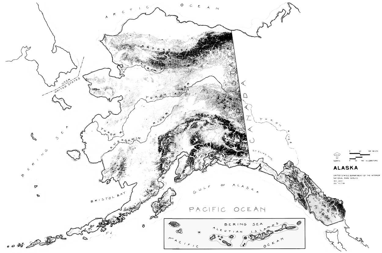
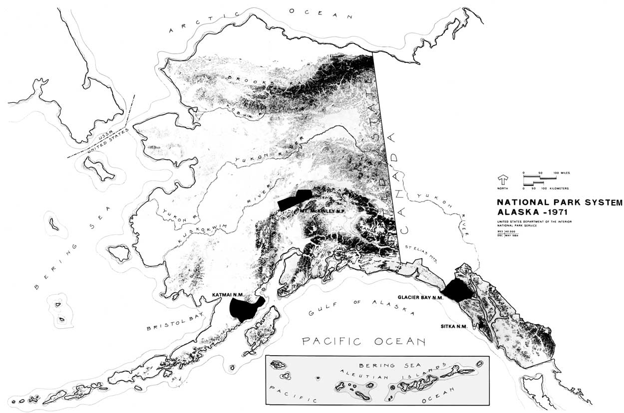
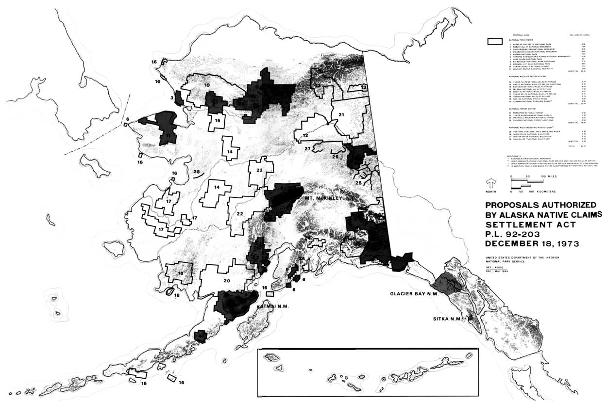
On January 11, 1972, the National Park Service forwarded its preliminary recommendations for withdrawal of twenty-one areas totaling 44,169,600 acres of land in Alaska for study as possible additions to the National Park System. 1 Part of a general Department of the Interior preliminary proposal that totaled 101,373,600 acres, the recommendations were mandated by section 17(d)(2) of the Alaska Native Claims Settlement Act (ANCSA) of December 18, 1971. 2
These preliminary recommendations were put together in a matter of days after the passage of ANCSA. They were not whimsical, however, but were based on a body of knowledge of the resources of Alaska gained through years of experience and study there. By 1972 the National Park Service administered four areas in Alaska that totaled just over 7,545,000 acres. 3 The Service had established a presence there, that, while too often superficial, perhaps, existed from its earliest days as an organization. In light of later events, it is perhaps ironic that the origin of the National Park System in Alaska is to be found in President William Howard Taft's use of the Antiquities Act of 1906. Responding to a report that documented the destruction of resources in a public park (Totem Park) in the small southeastern Alaska fishing village of Sitka, President Taft invoked the Antiquities Act to establish Sitka National Monument on March 23, 1910. 4 Sitka National Monument was established to protect significant historic and cultural resources relating to the Russian-Tlingit battle of 1804, and cultural artifacts of southeast Alaska Natives. 5 Use of the proclamation provision for Sitka was not, however, the last time a president would invoke the Antiquities Act to protect what he deemed to be nationally significant resources in Alaska. In fact, before 1970 the National Park System in Alaska was one that existed primarily by executive action. The one exception was the 1,408,000-acre Mt. McKinley National Park, authorized on February 26, 1917, to protect the wildlife in an area of incomparable grandeur that included portions of the highest mountain in North America. 6 Establishment of Mount McKinley National Park was not the result of any broadbased movement, but, rather, was due largely to the efforts of the Boone and Crockett Club and, in particular, its game committee chairman, Charles T. Sheldon. Valuable support came from the Camp Fire Club of America, American Game Protective Association, and key officials in the Department of the Interior, including Assistant Secretary Stephen T. Mather, who would soon become the first director of the newly-created National Park Service. 7 It was Sheldon, however, a well-known naturalist, who first conceived of "Denali" National Park when he wintered on the Toklat River in 1907-08, initiated the process, secured the approval of Department of the Interior officials, did much to drum up support for the proposal, and drafted the initial boundaries. 8 Despite support from conservation groups, Department of the Interior officials, the governor of the territory of Alaska, and Alaska's delegate to Congress, James Wickersham, who introduced the bill in April 1916, the proposal ran into unexpected opposition in Congress—much of which apparently had little to do with the proposal itself. The bill was reported out of the House Committee on Public lands late in the session and passed the full House on February 19, 1917. The next day the Senate, which had already passed Senator Key Pittman's version of the bill, concurred in the amended House bill. President Woodrow Wilson signed the bill into law on February 26, 1917. 9 Officials in the newly-created National Park Service were surely pleased with passage of the bill that brought Mount McKinley National Park into the National Park System. Yet at the same time, they were concerned that the problems the bill encountered in the House might imperil future park projects. 10 As a result, when Robert F. Griggs and the National Geographic Society proposed establishing a national park in an area of extreme volcanic activity on the Alaska Peninsula later in 1917, Acting NPS Director Horace M. Albright indicated that such an action was impossible. 11 Although he personally agreed that the area surrounding Mt. Katmai, which still displayed the affects of a violent eruption that occurred in 1912, met national park criteria, Albright believed that protection would have to come through presidential, not congressional action. 12 Accordingly, Griggs and the National Geographic Society, aided by NPS officials, undertook a campaign that culminated when President Woodrow Wilson set aside the 1,087,990-acre Katmai National Monument on September 24, 1918. 13 The monument, which included primarily the active volcanic peaks surrounding Mt. Katmai, the Valley of Ten Thousand Smokes, and the most promising east and west access routes, was set aside, President Wilson said in his proclamation, to preserve an area that would
The proclamation made no mention of the wildlife, particularly bears, that is so significant a part of the visitor experience at Katmai today. Using the Antiquities Act to establish Katmai National Monument allowed the Service and its friends to protect an area of unquestioned national significance while avoiding a potentially costly battle in Congress. At the same time, it exposed another problem that is familiar today—the opposition of most Alaskans to withdrawal of lands by the executive branch of the Federal Government. This view was expressed in a letter from Territorial Governor Thomas Riggs, Jr., shortly after the establishment of Katmai National Monument:
Six years later, when another group sought to secure preservation of an area at Glacier Bay, the editors of the Juneau Empire expressed the attitude of Alaskans toward land withdrawals. Calling the proposal "A Monstrous Proposition," the paper said:
"It leads one to wonder," the editors wrote, "if Washington has gone crazy through catering to conservation faddists." 15 The fury of the editors of the Juneau Empire had been aroused when President Calvin Coolidge ordered the temporary withdrawal of land at Glacier Bay, pending determination of an area to be permanently withdrawn as a national monument. 16 The next year, following resolution of a conflict over boundaries, President Coolidge invoked the Antiquities Act to establish the 1,164,800-acre Glacier Bay National Monument. 17 As was the case with Katmai National Monument, the movement to establish a national monument at Glacier Bay was due primarily to the efforts of scientists and conservationists—in this case, the National Ecological Society—and the area was set aside to reserve a significant resource for scientific research. 18 In fact, with the exception of a statement regarding accessibility, the reasons for protection in the President's proclamation were those originally drafted by the National Ecological Society: protection of tidewater glaciers and a large stand of coastal forests in natural conditions, the unique opportunity for scientific study "of glacier behavior and of resulting movements and development of flora and fauna and of certain valuable relics of ancient interglacial forests." 19 One additional area—Old Kasaan National Monument—was administered by the Service for some twenty years. Located on Prince of Wales Island in Southeast Alaska, Old Kasaan was set aside by President Woodrow Wilson on October 25, 1916, to protect the ruins of a former Haida Indian Village. 20 Because Old Kasaan was in Tongass National Forest, the monument was originally administered by the Forest Service. Administration was transferred to the NPS by Executive Order 6166 on August 10, 1933. 21 The monument was abolished on August 25, 1955. 22 With establishment of Glacier Bay National Monument, the National Park System in Alaska prior to 1972 was complete, save boundary adjustments and the transitory inclusion of Old Kasaan National Monument. In addition to the one historical area (Sitka National Monument), the system consisted of three natural areas that were places of superlative beauty and grandeur seldom matched elsewhere. Moreover, Katmai and Glacier Bay were recognized as being unique living laboratories for students of volcanism and glaciology, and Mt. McKinley National Park was recognized, as it is today, as one of the world's great wildlife reserves. It was, too, a system that reflected some of the unique conditions encountered in Alaska. In size alone, the parks mirrored the place—only Yellowstone exceeded the three natural Alaskan areas in size in 1925. The four Alaska areas made up slightly more than forty percent of the total acreage of lands administered by the National Park Service in 1925. 23 An examination of the legislation, moreover, reveals at least some effort to make adjustments to unique conditions in Alaska. Mount McKinley National Park, for example, was left open for mining, and section 6 of the enabling legislation of that park stipulated that "prospectors and miners engaged in prospecting or mining in said park may take and kill therein so much game as may be necessary for their actual necessities when short of food." 24 Despite such efforts to make the areas more palatable to Alaskans by tailoring the legislation to local concerns, the Alaska park units existed primarily as a result of executive action taken under the authority of the Antiquities Act of 1906. Particularly in the anti-government, individualistic Alaskan society, this meant that neither the areas nor the agency that managed them would enjoy the broadbased support most often enjoyed in the "Lower 48." 25 Combined with the size of the areas and distance from the central office, this lack of support, that sometimes amounted to hostility, would have made the job of managing the Alaska areas difficult at best. Given a parsimonious Congress, the nature of the organization of the Service itself and its interpretation of its mission, providing adequate management of the Alaskan areas was, until the 1960s, something that too often eluded the National Park Service. B. NPS Administration in Alaska, 1916-1950
Vandalism to nationally significant resources moved President William Howard Taft to proclaim Sitka National Monument. Yet, when he did so, no effective administrative machinery existed within the Department of the Interior for managing and protecting the national monuments. 26 No individual or office within the department was responsible for the existing national parks. Although a certain general responsibility for administering the national monuments under the Interior Department had devolved upon the General Land Office (later Bureau of Land Management) the lack of funds prohibited any effective management. Year after year Congress refused to appropriate anything for managing the monuments, and when it finally did in 1916, the amount was only $3,509 to be divided among nineteen monuments. The result was that before 1916 no effective preservation or restoration work could be undertaken at the monuments, and what supervision existed had not "prevented vandalism, unauthorized exploration, or spoliation." 27 After the newly-created National Park Service took control of the national parks and monuments under the jurisdiction of the Department of the Interior in 1917, a custodian, W. Merrill of Sitka, was appointed to oversee Sitka National Monument. 28 Over the next several years the Service began to make some much needed repairs there. It concluded an agreement with the Alaska Road Commission to do the work, and allotted $1,000 in 1918 and $1,102.48 in 1924 for improvement projects that included repair and painting of the totem poles. 29 In general it is apparent, however, that creation of an organization with specific responsibility for administering the national parks and monuments had a much lesser effect on the Alaskan areas than it did elsewhere. Distance to Alaska was a significant factor. Successive NPS directors did visit Alaska, beginning with NPS Director Mather's 1926 trip. 30 However, Alaska was reached primarily by boat before the 1940s. Even after that, the areas were too far, too remote, and communication was too difficult to have had a significant impact on policymakers in Washington, D.C. Organization of the Service was not something that could overcome this problem. Until 1937 superintendents and custodians reported directly to the Washington Office. After the Service established regional offices in that year, managers of the Alaska areas were responsible to the regional director in San Francisco, something that did little to overcome the essential problem of distance.31 Following World War II, several people, including Director Newton B. Drury, indicated a growing concern over the problem of communication between the central offices and park managers in Alaska, and recommended establishing a NPS Alaska Office in Juneau. 32 Such suggestions were ignored until the mid-1960s, however. Management priorities established by the Service in the 1920s and 1930s worked to the disadvantage of the Alaska areas as well. NPS Director Mather was determined to guarantee the national parks a firm place in the nation's consciousness. 33 One way to do so was an extensive publicity campaign to make the parks more well known. A second was to make park development a management priority in an effort to make the areas more pleasant places to visit. This meant quite simply that funds would go primarily to areas with high visibility and high visitation. The Alaskan areas had neither. Generally, they had the lowest visitation in the system. Mt. McKinley did not record a purely park visit until 1922, although many people with mining business at Kantishna traveled through the park. 34 From 1921 to 1930, Mt. McKinley reported 4,284 visitors. During that time only 32 people reportedly visited Katmai. By way of comparison, Yellowstone National Park reported a total of 1,724,880 visitors during those years. 35 In the 1930s energies within the Service were expended, in large part, in dealing with the myriad recovery programs in which it was involved, incorporating the more than sixty areas that came into the system through the reorganization of 1933, and in dealing with a variety of new kinds of areas established during that decade. 36 Although a detachment of 200 Civilian Conservation Corps men arrived at McKinley in 1938, emphasis remained on areas with highest visitation in the "Lower 48" and Alaska was again forgotten. 37 The attitude of Congress with respect to funding contributed to the difficulty. For the greater part of the period before the 1950s and 1960s, and this included the 1930s, when the Service was the recipient of considerable emergency largesse, Congress steadfastly refused to provide much more than minimal funding for Alaskan areas. The legislation for Mt. McKinley, in fact, included a stipulation that prohibited expenditures of more than $10,000 for maintenance, "unless expressly authorized by law." 38 When the bill passed, moreover, Congress provided no funds for administering the area. It was not until 1921, nearly five years after the park was established, that NPS Director Mather was able to announce that an $8,000 appropriation had allowed the Service to appoint a superintendent and take administrative control of the area. 39 Funding difficulties were not confined to Alaska, it must be made clear. The Service, until the 1930s and again afterwards, generally had difficulty obtaining adequate funding for managing parks and monuments everywhere. This is not to ignore the sometimes heroic efforts of the people on the ground in Alaska. Nor is it to suggest that nothing was accomplished in the first several decades of National Park Service administration there. Between 1922 and 1929 a total of $126,860 was appropriated for Mt. McKinley National Park. 40 This was spent not only for normal administrative and protective activities, but included such things as construction of a headquarters complex between 1925 and 1929, ranger patrol cabins, a trail from McKinley Park Station to Muldrow Glacier, and beginnings of a road that would, when completed in 1938, extend eighty-nine miles from McKinley Park Station to Wonder Lake. 41 In the mid 1930s the Service played a major role in construction of a hotel at the park. Designed and constructed under the supervision of Service personnel, the hotel was completed at a cost of $350,000. 42 Administration of Katmai and Glacier Bay, and later, Old Kasaan national monuments proved to be another story. Funding for national monuments everywhere was always more precarious than it was for the parks. In 1930, for example, only $46,000 was appropriated for protection of all thirty-two national monuments. 43 An added problem was the fact that although the distinction between parks and monuments was often vague, in terms of administration they were different. National parks were to be developed in order that they might become "resort[s] for the people to enjoy," while monuments were areas of national significance to be protected from encroachment. 44 This distinction remained sharper in Alaska for a longer period than it did elsewhere. Added to the factors already discussed, the result was near total neglect of Katmai, Glacier Bay, and Old Kasaan national monuments before 1950. In 1920, in response to an inquiry regarding Katmai, for example, Arno Cammerer wrote that the Service had no immediate plans to develop the area, and because of the lack of adequate transportation, had no representative on location. 45 Twenty years later, when NPS employees Frank T. Been and Victor Cahalane made an inspection tour of Katmai, the situation remained unchanged. Twenty-two years after Katmai was established, Been wrote, "so far as I can determine I am the first National Park Service officer who has visited" the area. 46 In 1963 Lowell Sumner wrote, that as late as 1948 the Service had still not made even the most rudimentary reconnaissance of the area. 47 Similarly, when Been and Earl Trager visited Glacier Bay in 1939, they were apparently the first Park Service employees to have spent any time in the monument, and were among the first to have even visited the area. Although the purpose of their visit indicates an interest in establishing a presence in the area—they were to study possibilities and methods for making the area and its story available to the visiting public—nothing more was done, and the record indicates that Park Service officials visited the area only infrequently until spring 1950. 48 Neglect had its most pronounced effect at Old Kasaan. There is little evidence to indicate that the U.S. Forest Service had done anything to protect the resources there during the period it managed the area. In 1921, in fact, that Service suggested transferring "old totem poles and Indian relics"—the very reason for existence of the monument—to Sitka National Monument. 49 The Park Service assumed jurisdiction, but not management of the area in 1933. Until 1941 direct supervision rested with the Alaska Road Commission under an agreement with the NPS. This arrangement did nothing to reverse the deterioration of the area. No funds were ever expended on the area, and when an inspection was finally made in 1940, the area was so overgrown that walking was virtually impossible, graves were opened, artifacts stolen, and more than half of the totem poles were gone. 50 In 1946, and again in 1954, the Service recommended the abolishment of the monument. The last time it did so in the recognition that the deterioration was irreversible. In 1955 Congress granted the request and abolished the monument. 51 On June 8, 1940, Mt. McKinley National Park Superintendent Frank Been wrote bitterly:
Despite Been's concerns, neglect of the other Alaskan areas did not have so serious consequences as at old Kasaan. Congress' failure to appropriate funds for Mt. McKinley did allow hunting to go on far in excess of that contemplated in the law, a problem that was only partially mitigated by assistance from the overworked and undermanned territorial game wardens. When Frank Been visited Katmai in 1940, he observed that hunting and trapping was carried on there "with the same freedom as . . . in the public domain." Excavation of pumice from beaches at Katmai occurred in the late 1940s and early 1950s. 53 Generally, however, because of the remoteness of the areas and the relative lack of population and developmental pressures, administrative neglect of the Alaska parks and monuments was not as serious as it might have been. 54 External factors, not design, served to buffer the areas from serious and irreversible encroachment and damage. However much Alaskans might oppose withdrawal of public lands by executive action, they were equally adamant, once those lands were withdrawn, that they should be developed and made available for use. Failure to more actively manage the Alaska parks and monuments did serve to reinforce perceptions in Alaska that the federal government was insensitive to the needs of Alaskans. 55 It created a situation, moreover, in which politicians could seriously propose abolishing an area of the unquestioned significance of Katmai National Monument. 56 It did serious damage to the image of the National Park Service in Alaska, and made it more difficult, into the 1970s, for the Service to muster support for its efforts to bring additional areas in Alaska into the National Park System. 57 National Park Service officials were not unaware of the problems the Service faced in Alaska. From the mid-1940s, successive directors did try to improve the situation there. These efforts, which were often the result of urging from NPS officials who had a special interest in Alaska, were sporadic until the mid-1950s and did not, until the mid-1960s, result in any reappraisal of the Service' s role in Alaska. Until the 1950s, moreover, these efforts to improve administration of the Alaskan areas, such as that Director Newton B. Drury recommended in 1946, had little apparent effect on the situation there. 58 C. National Park Service Studies in
Alaska, 1937-1946
Although the Service did not more actively manage the existing areas in Alaska before the 1960s, it nevertheless succeeded, over the years, in building a basic body of knowledge about Alaska and the park values there. Before the early 1950s, this did not result from any well-conceived program initiated by the Service itself, but resulted primarily from a number of proposals to set areas in Alaska aside as national parks and monuments. As often as not these proposals came from interested parties outside the Service. Each proposal for inclusion of a new area in the National Park System, whether it came from within the Service or outside, required some kind of study. Although the Service and its supporters were unable to bring additional areas into the system before the 1970s, the result of their efforts would be the accumulation of a body of knowledge about Alaskan lands that, while by no means comprehensive, would provide a firm base of information on which to build when the Service did assume a more active role in Alaska. A number of the areas suggested as potential national parks surfaced, in one way or another, time and again over the years. One such area was Admiralty Island in Southeast Alaska, proposed as early as 1928 as a national park to protect the Alaska brown bears that inhabited the area. 59 Park Service officials inspected the area in 1932, 1938, and again in 1942. Each time they concluded that while the island was an area of great beauty, it did not meet criteria necessary for inclusion in the National Park System. 60 Nevertheless, the issue was raised so many times that in 1963 Conrad L. Wirth wrote, in exasperation, "we have said 'no' on Admiralty more times, I believe, than there are . . . Alaska brown bears!" 61 Wirth exaggerated only slightly. Despite the negative reports, the issue was raised again in 1947, 1948, 1950, 1955, 1962, and would not be finally settled until 1977. 62 A second area that received consideration again and again, but never found its way into the system was Lake George, an interesting self-dumping glacial lake located forty-four miles northeast of Anchorage. The area was first proposed in 1937. A 1939 NPS report indicated that, although Lake George was an interesting phenomenon, it lacked the national significance required for national park or monument status. Nevertheless, the Service studied Lake George in 1958, 1961, and 1967, when the Anchorage Times proposed park status for the area. The suggestion was rejected each time, but on July 26, 1968, Lake George did become the first national natural landmark in Alaska.63 More important, in that it did become part of the system, were efforts to include various portions of the Wrangell-Saint Elias Mountains region, an area along the Canadian border that contains some of the highest mountains in North America. 64 The Forest Service had recommended establishment of a national monument in the Wrangells as early as 1908, and Senator Lewis Schwellenback of Washington and Alaska Delegate Anthony Dimond proposed establishing an international park on the Alaska-Yukon-British Columbia border in 1937. Park Service interest in the Wrangell-St. Elias region, however, dates to 1938 when Ernest Gruening, then director of the Interior Department's Division of Territories and Island Possessions, suggested that the Service survey the Chitina Valley for possible inclusion in the system. 65 In August of that year, Gruening, along with Harry J. Leik, superintendent of Mount McKinley National Park and NPS Chief of Forestry John Coffman, surveyed the area. They concluded that the area measured up to the very highest of national park standards, stating that "among our national parks, it would rate with the best, if in fact it would not even exceed the mountain scenery of existing national parks." 66 "Alaska Regional National Park" and "Panorama National Park" were two of the names suggested for the area roughly bounded by the Wrangell Mountains on the north, Chugach Mountains on the south, Copper River on the west, and Canadian border on the east. The new national park would have combined recreation, scenic values, and continued development—particularly mining. In an addendum to the Coffman-Leik Report, Gruening proposed the immediate establishment of a 900-square-mile Kennicott National Monument, to include the Kennicott Glacier and Kennicott mine site. 67 By 1940 success for Gruening's proposal seemed certain when Secretary of the Interior Harold L. Ickes forwarded a draft proclamation to President Roosevelt. Roosevelt refused, however, to sign the proclamation, citing "the emergency with which we are confronted." 68 Later that year, a negative study by Frank Been effectively killed the Kennicott National Monument proposal. 69 A significant aspect of the Wrangell/Saint Elias proposal was continued interest, on both the part of Canadians and Americans, in creating a great international park in the area. This idea was first raised in 1938, came up again in 1944 in response to a Canadian withdrawal of some 10,000 square miles on their side of the border, and was implicit, or explicit, in various expressions of interest in the area raised in 1952, 1964, 1965, 1966, 1967-68, and 1969-72, when the Service conducted intensive, but ultimately unsuccessful, negotiations with Canadian officials regarding establishment of an international park. 70 Surveys of these, and other areas across Alaska—Mt. Shishaldin, Kenai, Amagat Island, for example—were of unquestionable importance in building a body of knowledge about Alaska. They were, however, piecemeal. The first opportunity to go beyond the narrow limits of a specific area was associated with the Alaska Military Highway (Alaska Highway). In 1942 the Service had been asked to provide technical comments on the proposed military highway. In 1943-44 Service personnel undertook a survey of the scenic and recreational potential of a forty-mile wide strip along the entire length of the highway in Alaska that had been withdrawn by Secretary Ickes in an effort to establish a common conservation approach with the Canadian government. 73 President Roosevelt authorized $50,000 for the project, and in June 1943 a four-man-team headed by Senior Land Planner Allyn P. Bursley began work on the project. 74 In December 1944 Bursley and his group presented the results of their work, which included a survey of all roads in Alaska. While concluding that no areas along the military highway need be withdrawn for park purposes, the study team argued that the Federal Government, but not necessarily the National Park Service, had a responsibility for providing accommodations for visitors, and fostering travel in Alaska. To this end they proposed a broad plan that included interpretive signs, construction of overnight facilities along the highway, and a full-scale tourist facility at Mentasta Lake. 75 Possibly the $4,472,000 estimated for carrying out the proposals proved prohibitive, but for whatever reason, nothing came of the survey team's proposals. The Department of the Interior did consider directing the Park Service to construct a model tourist facility in 1946, but no evidence to suggest this was accomplished was uncovered. 76 D. A New Beginning: The NPS in
Alaska, 1950-1960
Although little concrete came from the survey of Alaska's roads, it did serve to whet the appetites of some within the Service. George Collins and others in the Service began to argue that under the Park, Parkway and Recreation Act of 1936 the Service had an obligation to learn as much as possible about the territory and the recreational resources there. Accordingly, in 1950 the Service initiated the Alaska Recreation Survey, a project that would not be completed until 1954, the purpose of which was to develop long-range plans that would provide guidance for the Service, as well as others, in
Funded for $10,000 in 1950, with additional monies coming in succeeding years, the Alaska Recreational Survey team, headed by George Collins, chief, state & territorial division, Region 4, spent the next several summers in Alaska, learning as much about the territory as possible and inventorying the resources there. In 1950, for example, one group conducted a survey of Southeast Alaska, then moved on to study Kodiak Island and Katmai National Monument, while a team of historians traveled up the Alaska Highway, checking into museums and libraries in Canada and Alaska. 79 The survey team quickly discovered that not only was the Park Service's knowledge of Alaska superficial, but that any detailed knowledge about the land was surprisingly scanty. The Alaska Recreational Survey, as a result, contributed not only to the Service's understanding, but made major contributions to a more general body of knowledge about Alaska. Over the next several years the Alaska Recreation Survey sponsored, among other things, a comprehensive study of the economic aspects of tourism in Alaska, the first comprehensive geological survey of the territory, a thorough biological study of Katmai, a preliminary geographical study of the Kongakut-Firth River area in Northeast Alaska, and developed a broad-scale recreation plan for Alaska. 80 In 1952, moreover, the team studied and first proposed establishment of an Arctic Wilderness International Park on the northeastern Alaska-Yukon border, an area that became the Arctic Wildlife Range on December 6, 1960. 81 Elsewhere within the Service, evidence of a growing interest in Alaska was evident in the early 1950s. In 1953 Grant Pearson, superintendent of Mount McKinley National Park, published his study of the history of that park, and in 1954 John Kauffmann, a NPS planner with a special interest in Alaska, produced boundary histories of Katmai, Glacier Bay, and Mount Mckinley. In 1952 Arthur A. Woodward completed "A Preliminary Survey of Alaska's Archeology, Ethnology, and History," a study supplemented in 1961 when NPS historian Charles Snell visited some forty-five historic sites across Alaska on behalf of the Historic Sites Survey. 82 The survey of historic sites in Alaska was part of a more general, nationwide survey that had been initiated in 1937 and suspended during World War II . Funding for the program after 1956, including the studies done in Alaska, came from Mission 66—a broad program initiated by NPS Director Conrad L. Wirth that was designed to upgrade all facilities and services in the National Park System. 83
Money from Mission 66 provided, in some cases, the first development money in the existence of the Alaska areas. In three years, from 1957, when the program got underway, until 1960 some $12,942,400 went to the four Alaskan areas 84. Mission 66 provided funds for vastly-needed improvement of the park road at Mt. McKinley. Work began on a headquarters, residential, and operational facilities at Katmai, and two projects long urged by Alaska's newly-elected Senator Ernest Gruening—a tourist facility at Glacier Bay's Bartlett Cove, and a controversial jeep trail into Katmai's Valley of the Ten Thousand Smokes—were completed. 85 Mission 66 was not, however, merely a construction and development program as many believe. Among other things, it provided funds for preparation of boundary revision studies; a nation-wide plan for parks, parkways, and recreation areas that included an inventory of existing areas and proposals for new areas, and planning for the "orderly achievement of a well-rounded system." 86 In 1960, again as part of a broader, nationwide effort, George Collins hired Roger Allin, a long-time Fish and Wildlife Service employee in Alaska, to develop a general recreation plan for Alaska that would identify areas that should be protected by the federal, state, or local governments. The material Allin developed, along with similar recreation plans and proposals for additions to the National Park System prepared by staffs of all regional offices, was compiled in the 1964 NPS publication, Parks for America. 87 In terms of future national parks in Alaska, Parks for America proved a conservative document that listed only two areas as potential national parks—Saint Elias-Wrangell Mountains (800,000 acres) and Lake Clark Pass (330,000). 88 Additionally, Allin, along with Theodor Swem, a NPS planner then attached to the Washington office, participated in a joint federal-state survey of the Wood-Tikchik area in southwestern Alaska in 1962. While in Alaska they also made an initial reconnaissance of Round Island, looked at Lake George and Lake Clark, and conducted a brief boundary survey of Katmai. 89 The next year Swem returned to Alaska, accompanied by Sigurd F. Olson, to inspect potential areas that included Wood-Tikchik, Lake Clark, Skagway, and proposed boundary extensions at Mount McKinley. 90 Mission 66 was unquestionably a major step forward for the National Park Service in Alaska. For the first time money had been made available for tourist facilities that would begin to make Katmai and Glacier Bay national monuments more accessible. Roger Allin had been able to collect much of the available information to develop a plan for protecting a number of critical areas across the state. Under Mission 66 the Service had begun to take the necessary first steps to correct past inaction, and lay the foundation for a much broader effort to follow. E. The National Park Service in Alaska,
1964-1971
Mission 66 was a nationwide program. What it did not do in Alaska was stimulate a broad reappraisal of the Service's role there, or bring about significant changes in approach to management of NPS areas. 91 Despite the very real accomplishments of Mission 66, when John Kauffmann traveled to Alaska in 1964 to participate in making of a Park Service film about the Alaskan parks, he was appalled by what he observed of the NPS presence in the state. 92
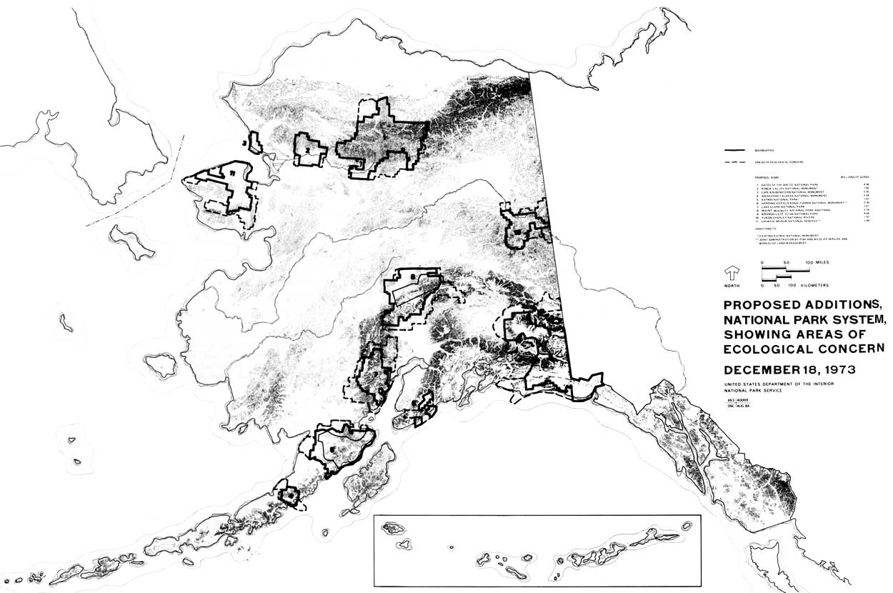
In a stinging rebuke that was circulated widely in the Service's Washington office, Kauffmann wrote eloquently of opportunities lost, of a failure to make adjustments to the Alaska environment, and of failure to develop any well-thought-out concept of what the Service's mission in Alaska should be. The Service had failed, even, to make its presence known in the state. "Indeed," he wrote, "after more than forty years as an organization, the Service is the Cheechako of all federal agencies at work in Alaska." 93 Kauffmann's call for a reappraisal of the Service's role in Alaska came at a most auspicious time. Changes were taking place in the Service, changes that would have a significant effect on the National Park System in Alaska. George B. Hartzog, Jr., the dynamic, forceful new director who had replaced Conrad L. Wirth on January 8, 1964, was determined to build on Wirth's many achievements, and made protection of the "surviving landmarks of our national heritage" as a primary goal of his administration. 94 Hartzog recognized early on that if any significant growth of the park system were to occur, that growth would have to be in Alaska. 95 Hartzog chose Theodor R. Swem, a planner with a life-long interest in Alaska as his assistant director for cooperative activities, with responsibility for planning and new area studies. In that position Swem would be able to use his influence to obtain greater funding for the Service's efforts in Alaska than ever before, and to direct a more comprehensive planning program for Alaska than previously envisioned. At the regional level, John Rutter, first as director of the Western Region and later of the Pacific Northwest Region, would make improvement of the NPS operation and facilities in Alaska an important part of his program. 96 In November 1964 Hartzog appointed a special task force to prepare an analysis of "the best remaining possibilities for the service in Alaska." 97 The group, made up of the most knowledgeable "Alaska hands" available, took the broadest possible view of their assignment, and their report, Operation Great Land, was a broad appraisal of the Service's performance in Alaska, with recommendations for the future. 98 As had John Kauffmann the year before, the Task Force was most critical of the Service's past actions in Alaska. With full knowledge of the potential of Alaska, they wrote, the Service had done little, "except give lip service to the broad concept." Pointing out that total visitation to the Alaska areas was only a "pitiful" 42,131 in 1964, the Task Force warned that neither Alaskans, nor Americans generally would support the Service's program in Alaska unless major steps were taken to correct past deficiencies. Concluding that "the time has come for action, not words," the group recommended that the Service take a far more active role in Alaska to establish a program of investigation, study, planning, and development and operations. Among the specific recommendations were development of a broad history program; establishment of an Alaska office in Alaska; and cooperative ventures with Canada, state, and other federal agencies in Alaska. Finally, the group made a comprehensive evaluation of potential areas in Alaska, identifying thirty-nine zones and sites across the state which contained recreation, natural, and/or historic values. These zones and sites, which are shown in Illustration 2, included many areas that the Service had long been interested in, and which would be given protection in the Alaska National Interest Lands Conservation Act of 1980. 99 Many of the Task Force's observations had been made before. Park Service officials had called for creation of an Alaska office since 1946. Theodor Swem and John Kauffmann had reached similar conclusions regarding the NPS presence in Alaska in 1962 and 1964, and had recommended some of the same corrective actions. 100 The following year Roger Allin would issue a similar, if somewhat more conservative, proposal in his "Alaska, A Plan for Action." 101 Additional support came from the Federal Field Committee for Development Planning in Alaska. The committee saw parks as having a vital role in the development of Alaska's economy, and called upon both state and federal governments to look at Alaskan parks, and to establish an "entire park complex" that would "meet the needs of the American people." The committee recommended establishment of a national park in Arctic Alaska, and identification of other areas for future designation. 102 Perhaps the general tone of the Operation Great Land struck Director Hartzog as being too aggressive. Whatever the reason, in what was surely an uncharacteristic display of reticence, he decided not to circulate Operation Great Land, explaining:
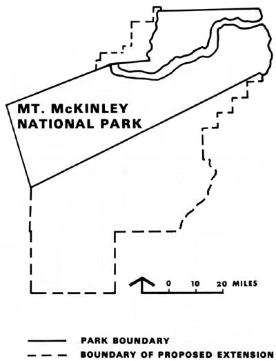
Whatever his reasons for refusing to circulate Operation Great Land, George Hartzog's decision certainly did not reflect any opposition on his part to an increased NPS presence in Alaska. Over the next several years he took steps to reverse a long-standing funding imbalance and, although budget cutbacks were forcing the Service to reduce visitor hours and close campgrounds elsewhere, more money went to Alaska. 104 In 1966, moreover, he considered the possibility of developing a program for the state, based "upon a practical application of the [Collins] report." 105 This suggestion was not, apparently, pursued further. Nevertheless, a number of recommendations in the Task Force's report were implemented in some form over the next several years as the Service moved to expand its role in Alaska. In the summer of 1965, for example, the Secretary's Advisory Board on National Parks, Historic Sites, Buildings, and Monuments toured Alaska with George Hartzog, Theodor Swem, and others, on a trip that secured important support for the Service's effort to expand and improve its operations in the state. 106 Later, in 1967, in a meeting with Governor Walter Hickel, Director Hartzog made an effort to initiate a series of cooperative planning ventures with the state of Alaska at Wood-Tikchik, Alatna-Kobuk, and Skagway. Although Hickel appeared to be most receptive to Director Hartzog's suggestions when they met, he followed through only on the Skagway study. 107 By August 1965, moreover, Director Hartzog had decided to open a NPS office in Anchorage. The Washington office had begun to screen applications for the position of park planner in Anchorage in November of that year, and by April 1966 the Service had established an office in Anchorage in the person of park planner Harry Smith. 108 In December 1966 Bailey Breedlove, a landscape architect from the Service's National Capital Regional Office replaced Smith in the Anchorage Office, and by May 1967, the Alaska Field Office had a permanent staff of three—Breedlove, Dick Prasil, a biologist from the Western Regional Office, and a secretary. 109 Administratively, the Alaska Field Office functioned as an organizational division of Mount McKinley National Park. As such, the staff in Anchorage was under the direct supervision of the superintendent of Mount McKinley National Park, although it was given unusually wide latitude in carrying out its duties. The superintendent of Mount McKinley reported to the regional director in San Francisco. In 1969 the Service created a northwest district office in Seattle with responsibility for Alaska, and by early 1971 a fully-staffed and operational Pacific Northwest Regional Office, also in Seattle, had assumed responsibility for Alaska. 110 The superintendent of Mount McKinley was, in addition, the state coordinator for Alaska. In this capacity, he was the Service's representative for all statewide programs and liaison with the state government and other federal agencies. 111 Personnel assigned to the New Alaska Field Office would play an important role in an intensive planning program initiated in 1967 by Ted Swem's Washington Office of Cooperative Activities. Over the next three years, planning teams, led by Merrill Mattes, a historian in the office of resources planning in the Service's newly created (1966) San Francisco Service Center, prepared master plans for existing areas, and added to the Service's knowledge of Alaska generally, as they studied potential additions to the system. 112 In August of 1967 a team traveled to Attu Island, where they completed a study of alternatives. 113 In 1968 they prepared a master plan for Mount McKinley National Park that recommended, as had others before them, a two-unit addition of 2,202,238 acres. 114 Later that year he team traveled north, where they conducted the initial NPS study of the south slope of the Brooks Range. In Kobuk-Koyukuk: A Reconnaissance Report, Mattes and his group recommended establishment of a two-unit "Gates of the Arctic National Park," that would protect some 4,119,000 acres of the finest remaining wilderness in America. 115 Master planning work went on, additionally, at Glacier Bay and Katmai. Planning teams studied a proposed Klondike Gold Rush National Historical Park at Skagway, updated a 1965 feasibility study of the Erskine House at Old Kodiak, and in 1969 investigated ways of preserving the heritage of Alaskan Natives through creation of cultural centers. 116 By the mid-1960s, moreover, the Service began to evaluate a number of Alaska sites under the National Landmark Program. On May 3, 1967, for example, Assistant Director Swem made $20,000 available for studies of potential natural landmarks. 117 Richard Prasil, who coordinated the program in Alaska, announced that the University of Alaska had agreed to conduct evaluations of seven potential areas that included Walker Lake and the Arrigetch Peaks in the Brooks Range. Ellis Taylor contracted to study six volcanic areas, including Aniakchak Crater and Mount Veniaminof, and the Service undertook studies of a number of other areas, one of which was the Imuruk Lava Fields. 118 The natural landmark studies in Alaska were conducted in a haphazard manner. Rather than following the established procedures of conducting a state or regional survey of themes, followed by site evaluations, the Alaska studies were conducted on an area by area basis. 119 No broad survey was attempted, in fact, until the early 1970s, when the Service published a study of potential natural landmarks in the Arctic Lowlands. 120 Nevertheless, by 1968 fifteen sites in Alaska, including the Arrigetch Peaks, Walker Lake, Lake George, and Aniakchak Crater had been recognized as registered National Natural Landmarks. Evaluations of sites all across Alaska conducted under the program would give NPS planners, as well as those from other agencies, valuable information regarding significance of resources needed in making withdrawals mandated by the Alaska Native Claims Settlement Act of 1971. 121 The Service's studies and surveys of potential park areas in Alaska had been piecemeal. It was only in the 1965 report of George Collins's task force that any attempt to make a comprehensive analysis of potential national parks in Alaska was undertaken. By the end of the 1960s, however, and into the 1970s, a number of efforts to make a comprehensive survey of potential national parklands in Alaska were underway. One such effort was undertaken by Richard Stenmark, a NPS employee, in his capacity as executive secretary of Secretary of the Interior Walter Hickel's fourteen-member Alaska Park and Monuments Advisory Committee, established in 1969 to give advice on development and potential parks in Alaska. 122 In addition, the Federal Field Committee for Development Planning in Alaska worked on a plan of action anticipated to launch a "full scale comprehensive joint Federal-State Land Use and Classification Plan for Alaska." 123 At the same time, following publication of the Park System Plan in 1970, the Park Service began an inventory of the National Park System to determine how adequately the existing areas illustrated the human and natural history of the nation, and to identify areas that would fill in any gaps in the system. By November 17, 1971, the Alaska Office had completed a proposed "National Park System Alaska Plan" that listed historical, natural, and recreation areas in the state for further study for possible inclusion in the National Park System. The list, which was essentially that prepared independently by Richard Stenmark for the use of the Alaska Parks and Monuments Advisory Committee, included most areas that would be withdrawn by Secretary of the Interior Rogers C. B. Morton pursuant to terms of the Alaska Native Claims Settlement Act of 1971: Historical Areas:
Natural Areas:
Recreational Areas:
The Service significantly increased the scope of its activities in Alaska during the 1960s, and undertook a comprehensive effort to identify, by theme, potential additions to the National Park System. Efforts to bring additional areas into the system in the decade met with almost universal failure, however, save for a small, 94,000-acre addition to Katmai National Monument in 1969. In 1965, for example, Secretary of the Interior Stewart Udall recommended legislation to convert Glacier Bay National Monument into a national park. Although seconded by Senator Ernest Gruening, who expressed interest in introducing such a bill, no action would be taken. In 1969-70, Senator Ted Stevens indicated an interest in gaining park status for a portion of Misty Fjords and the Rudyard Bay-Walker Cove area. In 1969 Senator Mike Gravel spoke of establishing a Kodiak National Historical Site, and Representative John Saylor introduced the first of several bills to extend the boundaries of Mt. McKinley and to establish Gates of the Arctic National Park. 125
In 1968, taking advantage of an entree arranged by Dr. Carl McMurray of Governor Hickel's staff, the Service undertook negotiations with the city of Skagway and Canadian officials for creation of an international Klondike Gold Rush Historical Park, an effort that would include a widely publicized joint Canadian-American hike over the Chilikoot Trail in September 1969. 126 In 1969, moreover, the Service initiated a three-year-long dialogue with Canadian officials regarding an international park in the Wrangells-Saint Elias region. Successful conclusion to these discussions seemed to be within reach in 1972 when the Service completed a conceptual master plan, an environmental impact statement for the proposed Alaska National Park, and prepared the draft legislation necessary. However, just as the park that some had dreamed of for years seemed to be on the verge of reality, the effort foundered. 127 No failure could have been more disappointing to Park Service officials, however, than the aborted effort to establish more than 7,000,000 acres of new monuments in Alaska and elsewhere during the closing months of President Lyndon B. Johnson's administration. 128 The project—named "Project 'P'"—was conceived of by Secretary of the Interior Stewart Udall in the fall of 1968 as President Lyndon Johnson's "parting gift for future generations." 129 For Park Service officials it offered an unprecedented opportunity to add areas to the system. By early December fifteen original areas—six of them in Alaska—had been narrowed to seven. 130 Proclamations, as well as support data, had been prepared for Mount McKinley (2,202,328 acres adjacent to the park), a two-unit, 4,119,013-acre Gates of the Arctic, Katmai (a 94,547-acre western addition), Arches (49,943 acres), Capital Reef (215,056 acres), Marble Canyon (26,080 acres), and Sonoran Desert (911,697 acres). 131 Despite some four months of concentrated effort on the part of a number of people in the Park Service, other agencies, and Interior Department staff, President Johnson balked at the very last moment and refused to sign all the proclamations prepared for his signature. 132 The reasons for his refusal remain the subject of controversy. Among the reasons advanced are a sensitivity on the part of President Johnson to the prerogatives of Congress in the matter of setting aside public lands, his petulance over the premature release of information by Secretary Udall, Lyndon Johnson's ego, a concern that last-minute activity not bind successors, and presidential anger over Secretary Udall's failure to brief Representative Wayne Aspinall, the powerful chairman of the House Interior and Insular Affairs Committee, as he indicated he had. 133 Whatever the case, and the merits of the arguments are too complex to be examined here, President Johnson finally signed proclamations for Arches, Capital Reef, and Marble Canyon. The only Alaska area included was the 94,547-acre western addition to Katmai, an area that included the western end of Naknek Lake. 134 By the end of the 1960s and into the 1970s, the National Park Service had made substantial progress in its effort to reverse the long-standing neglect of Alaska parks. The existence of an Alaska office in Anchorage gave the Service a presence in the state that had been missing. Building on studies that went back to the 1930s, the Service had compiled an impressive body of knowledge about Alaska and the park resources there, and had identified a considerable number of areas that met criteria for inclusion in the National Park System. For a variety of reasons, however, NPS officials had been unsuccessful in their efforts to bring additional areas into the system, save the small, 94,000-acre tract added to Katmai National Monument. Coincidentally, however, a bill was working its way through Congress, one that on the face of it had little to do with national parklands. Yet, the Alaska Native Claims Settlement Act of December 18, 1971, would be the vehicle that would provide for parks in Alaska almost beyond the wildest dreams of anyone in the National Park Service. Chapter Two: The Alaska Native Claims Settlement Act A. Statehood Grants
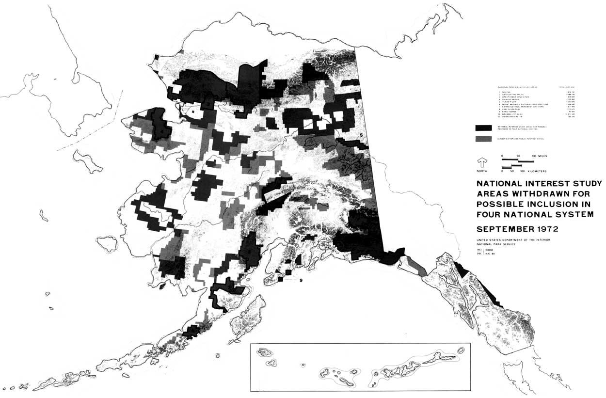
The Alaska National Interest Lands Conservation Act of 1980 provided for 43,585,000 acres of new national parklands in Alaska; the addition of 53,720,000 acres to the National Wildlife Refuge System; twenty-five wild and scenic rivers, with twelve more to be studied for that designation; establishment of Misty Fjords and Admiralty Island national monuments in Southeast Alaska; establishment of Steese National Conservation Area and White Mountain National Recreation Area to be managed by the Bureau of Land Management; the addition of 56,400,000 acres to the Wilderness Preservation System, and the addition of 3,350,000 acres to Tongass and Chugach national forests. It was, many believe, the most significant single piece of legislation in the history of conservation in the United States. In Alaska it represented, too, a significant step in the disposition of public lands in the state. 1 In 1958, when Congress passed the Alaska statehood bill after nearly two decades of lobbying by Alaskans, federal land reserves in the new state totaled 92,400,000 acres. Twenty million acres were in national forests, 23,000,000 acres in a naval petroleum reserve above the Arctic Circle, more than 27,000,000 acres in power reserves, 7,800,000 acres in wildlife refuges, and in excess of 7,500,000 acres in national parks and monuments. The federal government was, additionally, trustee for more than 4,000,000 acres of Indian reservations. Only 700,000 acres in Alaska had been patented to private individuals, while another 600,000 acres were pending. The unreserved public domain consisted of 271,800,000 acres. 2 Two questions that emerged in the debate over Alaska statehood are particularly relevant here. What could be done, Congress asked, to guarantee that the new state would survive economically? A second, and even more vexing question, was one Congress had avoided in the past—what to do about the land claims of the Native peoples of Alaska. In an effort to provide the new state with a sound economic base, Congress proved to be generous by any standard. Alaska received the right to select 102,550,000 acres from the public domain, 400,000 acres from national forest land in Southeast and 400,000 acres from the public domain for community expansion, and 200,000 acres of university and school lands to be held in trust by the state. Congress also confirmed earlier federal grants to the territory that amounted to 1,000,000 acres. 3 Congress gave Alaska the right to select an area of land roughly the size of California—larger than that given all the other western states combined. 4 Moreover, Alaska could select mineral lands as part of its statehood grant, although the mineral rights transferred would be unalienable—that is they could be leased, but not sold. Finally, Congress gave Alaska a larger share of the mineral lease revenues on the public domain than any other state. 5 6??? 7???Natives—Aleuts, Eskimos, and Indians—made up some twenty percent of the population of Alaska in 1960. Although they were a minority of the population as a whole, they did constitute a majority in some 200 communities and villages spread across the face of rural Alaska. A considerable majority lived a subsistence lifestyle similar to that of their ancestors. Congress had, according to a 1963 report, sidestepped the question of their rights in the land for more than seventy years. An added difficulty Congress faced during the statehood debate was the existence of three Alaska cases then pending before the Court of Claims. 8 The Natives were unorganized in the late 1950s. Most lived in small, isolated villages spread across Alaska. As a result, the question of their rights in the land was not one that Congress dwelled on during a statehood debate. After some discussion, the statehood act did include a provision in the law that merely reaffirmed the right of Congress to settle the Alaska Natives' claims in the land:
B. Native Land Claims
As Alaska state officials undertook the selection of land granted under the Statehood Act they faced a number of problems. In the first place, knowledge of what a large portion of Alaska's lands contained was still relatively superficial, something that made selecting lands that would provide a sound economic base obviously difficult. State officials admitted, moreover, that they did not have the financial wherewithal to provide adequate management for the lands. The statehood act allowed state officials, finally, twenty-five years to make selections. 10 As a result, state officials moved slowly in selecting land during the 1960s. By the end of that decade they had selected less than a quarter of their entitlement--some 28,000,000 acres, chosen in hopes of bolstering the state's economy, most notably in the oil, gas, and mineral industries. 11 Nevertheless, almost as soon as state officials began to divide rural Alaska, it became apparent that the failure to have addressed the question of the land claims of Alaska Natives in the statehood act virtually assured almost continual conflict. The state's efforts to select the most productive lands clashed, in many instances, with the Natives' need to use the land to maintain their traditional lifestyles. In 1961, for example, the Department of the Interior's Bureau of Indian Affairs filed protests over state selections on behalf of four Native villages that claimed about 5,800,000 acres of land near Fairbanks. State officials had already selected and filed for 1,700,000 acres of land near the Athabascan village of Minto, which they intended to develop as a recreation area for Fairbanks residents. State officials believed, as well, that the area possessed the potential for future oil and gas development. 12 The villagers of Minto, who were not consulted in the proposal, depended upon that land for their livelihood. They protested, recognizing that state plans to develop the area threatened their way of life. Other Native villagers across Alaska soon found themselves confronted by similar challenges. In 1965, for example, villagers in Tanacross, a small village near Fairbanks, were outraged when they discovered that the state intended to sell lots around their traditional fishing ground at George Lake to visitors at the Alaska booth at the New York World Fair. 13 Threats to the Native lifestyles from state land selections predominated in the early 1960s. They were not, however, the only problem Alaska Natives faced. In 1961, for example, the Inupiat Eskimo artist Howard Rock discovered that the United States Atomic Energy Commission planned to detonate a nuclear device at Cape Thompson on the northwest coast. The purpose was to create a harbor that would be used for shipment of minerals. Villagers at Point Hope, Kivalina, and Noatak, however, had long used the Cape Thompson area for hunting and egging. 14 In 1963 Natives along the Yukon River were outraged when Senator Ernest Gruening urged Congress to fund the huge Rampart Dam hydroelectric project of the Yukon Flats Region in northcentral Alaska. Especially galling to Natives in the area was Gruening's claim that the 10,000-square-mile lake that would be created by the dam would flood only a "vast swamp uninhabited except for seven small Indian villages." 15 When Congress debated Alaska statehood, the Alaskan Natives had been an unorganized, seemingly helpless group who had little voice in the decisions that would shape their future. By the mid-1960s, however, a growing self-awareness fostered by the recognition that their very way of life was in danger had galvanized the Natives. Native associations sprang up all over Alaska. After Howard Rock published the first edition of Tundra Times in 1962, the Natives had a common voice. When the Alaska Federation of Natives brought the village and regional associations together in 1966, a organized Native community emerged as a potent political force in Alaska. The question of their land claims could be ignored no longer. 16 In 1963 Secretary of the Interior Stewart Udall appointed a three-person Alaska Task Force on Native Affairs to study the entire question of Alaska Native land claims. Secretary Udall's action followed a request by some 1000 Natives from twenty-four villages in the Alaska Peninsula, Yukon River Delta, Bristol Bay area, and Aleutian Islands to impose a freeze on all transfers of land ownership in their villages until land rights could be confirmed. 17 Secretary Udall, it is obvious, ignored the request for a freeze on land transfers. The recommendations presented him by the task force he appointed would be unacceptable to Native groups as well—prompt granting of up to 160 acres to individuals for homes or fish camps, and hunting sites; withdrawal of "small acreages" for village growth; and designation of areas for Native use, but not ownership for traditional food-gathering activities. Nevertheless, the Interior Department had signaled that it, too, believed the time had come for settlement of Alaska Native land claims. 18 Three years later, the newly-formed Alaska Federation of Natives made a similar request for a freeze on land transfers. In what was in part a recognition of the growing political power of the Alaska Natives, Secretary Udall stopped the transfer of all lands claimed by Natives until Congress had time to act on the matter. 19 The extent of the moratorium depended, of course, on number and extent of claims. By May 1967 thirty-nine claims ranging in size from the 640 acres claimed by the village of Chilikoot to 50,000,000 acres claimed by the Arctic Slope Native Association had been filed. In all, because of overlapping claims, about 380,000,000 acres--an amount greater than the land area of Alaska--was affected by the freeze. 20 Although some, Senator Gruening, for example, preferred that the question be resolved in the courts, most recognized that the problem of Native land claims demanded a legislative solution. As early as July 1966 the Bureau of Indian Affairs and Bureau of Land Management had prepared a draft of the bill "dealing with Alaska Natives land problems." 21 The first bills, however, were not introduced until the summer of 1967. In that year, one sponsored by the Department of the Interior, the other by the Alaska Federation of Natives, would have authorized a court to determine compensation for lands lost. The AFN bill would have allowed the court to award title to lands with no acreage specified, while the Interior Department's bill would have authorized a maximum of 50,000 acres in trust for each village. 22 Not until four years later, under considerably different circumstances would a settlement be produced. In his delightful book Coming into the Country, John McPhee wrote that the Alaska Natives Claims Settlement Act was
Perhaps. Joe Upicksoun, president of the North Slope Native Association advanced another explanation, however, when he told Native leaders attending a late 1970 Alaska Federation of Natives Conference:
Upiksoun referred, of course, to the 1968 discovery of oil at Prudhoe Bay on the North Slope by Atlantic Richfield Company (ARCO) and Humble Oil and Refining Company. He might have mentioned, as well, the plans announced by a consortium consisting of ARCO, Humble, and British Petroleum, Ltd. to construct an 800-mile-long hot oil pipeline from Prudhoe Bay to Valdez, a small fishing village on Prince William Sound. The discovery of oil, and the companies' awareness that no pipeline could be laid across the Yukon River Valley until land claims of the Alaskan Natives were settled, soon gave the Natives an invaluable ally in their fight for justice. 24 It is not too much to say, in fact, that concern on the part of Congress and the administration over delays in construction of the Alaska Pipeline System (TAPS) was as much responsible, or more, for passage and final shape of the Alaska Native Claims Settlement Act of 1971 than was concern for justice for the Alaska Natives. C. Origins of the National Interest
Lands Provision (17(d)(2))
The question of the disposition of the public lands in Alaska was not simply a two-sided one that involved the claims of the Natives and the state. A third element complicating any settlement of those issues was the question of the national interest—how and to what extent should the needs of Americans everywhere be addressed? As indicated previously, individuals and organizations outside the government had worked with staffs of federal agencies in an effort to secure preservation of areas of national, or international significance in Alaska. These efforts were sporadic in nature and did not represent any comprehensive approach to preservation of Alaska's lands. In 1963 the governing council of the Wilderness Society held their annual meeting at Camp Denali, near the border of Mount McKinley National Park. The very location of their meeting signaled a new concern for the future of Alaska's wildlands. A consensus developed during the meeting
Although this call by the Wilderness Society did not lead to an immediate demand for preservation of Alaska lands by conservationists in the "lower '48," by the end of the decade they had taken a more active interest in Alaska. In the state, an informal group of conservationists, many of whom were employed by state and federal agencies, worked to identify significant areas, and developed detailed data on those areas. 26 Following a 1967 trip to Alaska, Sierra Club President Dr. Edgar Wayburn hired an Alaska representative and made saving Alaska wildlands a priority goal of that organization. 27 Particularly after the discovery of oil at Prudhoe Bay, it seemed clear that time was running out if Alaska lands were to be preserved. 28 A growing number of people had become convinced, by the end of the decade, that the vehicle for preserving lands in Alaska, and perhaps the last that would ever be available, was the Alaska Native Claims Settlement bill then working its way through Congress. 29 It would become somewhat fashionable, later, to charge that the inclusion of the national interest lands provision in the Alaska Native Claims Settlement Act was a hasty, last-minute affair, written by "outsiders" who did not understand Alaska. Actually, however, it seems apparent that the idea that any settlement of the lands claims of Alaska Natives must also take into account the national interest originated with Joseph Fitzgerald, the far-seeing chairman of the Federal Field Committee for Development Planning in Alaska. 30 As early as 1965-66, Fitzgerald had concluded that economic development could not occur in Alaska until the Native land claims were settled, and that a significant factor in any settlement would be a major involvement of the state and federal governments in the establishment of a "park complex" in Alaska. 31 Fitzgerald approached the Alaska Wilderness Council, asking them to identify areas worthy of preservation. 32 It was, moreover, a member of Fitzgerald's staff—David Hickock—who was actually responsible for inclusion of the first "National Interest Lands" provision in any bill. Hickock, who was natural resources specialist on the Fitzgerald's committee staff, had been borrowed by the Senate Interior and Insular Affairs committee to work on a settlement bill. At his suggestion, a simple provision was added to S. 1830:
On July 15, 1970, the Senate passed S. 1830 by a seventy-six to eight majority. That version of a settlement act included provision similar to that drafted by David Hickock. The Secretary of the Interior was directed to conduct
Although the Senate passed its version of the bill, the House Committee on Interior and Insular Affairs was unable to reach agreement on a bill. Congress adjourned without completing action on the bill. 35 As the Alaska Natives and their allies regrouped in spring 1971 for what most believed would be the last act in the legislative process of an Alaska Native claims settlement bill, those who had cause to believe that the bill should be broadened to include a provision that would permit the designation of wilderness and provide for the addition to the park and refuge systems mobilized as well. A number of conservation organizations would unite to form the Alaska Coalition to more efficiently work for a national interest lands provision. 36 Earlier the governing council of the Wilderness Society had agreed to become involved in the effort, and by mid-March, Stewart Brandborg had asked the Senate Committee on Interior and Insular Affairs to consider including a five-year, land-use planning program for Alaska. On May 3 Brandborg testified before the House Committee on Interior and Insular Affairs, suggesting, among other things, that they include a provision that would authorize the identification, preservation, and establishment of "areas of national significance as units of the National Park and National Wildlife Refuge and National Wilderness Preservation systems" in any Alaska Native claims settlement. Others in the conservation community would approach Representatives John Saylor and Morris Udall of Arizona to secure their help. By May Congressman Saylor had let it be known that he would offer an amendment that would require land-use planning in Alaska as a part of any settlement. 37 Saylor apparently decided, however, that success in the House would be difficult to achieve and that it would be necessary to secure help in the Senate. He called Nathaniel P. Reed, Assistant Secretary of the Interior, to ask his help in building up support for a national interest lands provision in a senate bill. 38 Representative Saylor also called NPS Director George Hartzog to ask that he approach Nevada Senator Alan Bible, chairman of the Senate Subcommittee on National Parks and Recreation, to enlist his help. Although Hartzog was unable to obtain a commitment from Senator Bible at that time, he did convince the senator to accompany him to Alaska the coming summer (1971) to inspect potential park areas in the state. 39 That August Hartzog, Bible, their wives, and several of Senator Bible's friends traveled in Alaska, viewing potential park areas that included Gates of the Arctic, areas in the Kenai Peninsula, Skagway, and possible extensions to Mount McKinley National Park and Katmai National Monument. 40 Upon their return, Senator Bible promised Hartzog that he would sponsor a park study amendment that fall, and also indicated that he would arrange to be on any conference committee held on the bill should that be necessary. Senator Bible requested, in turn, that Director Hartzog provide him with the appropriate language of an amendment. 41 Director Hartzog understood that the amendment Senator Bible had agreed to introduce would address additions to the National Park System in Alaska with an additional 4,000,000 acres for "minor boundary adjustments" at existing wildlife refuges and national forests. Among the areas Hartzog envisioned in an expanded National Park System in Alaska were a huge Gates of the Arctic National Park that extended north from the Arctic Circle across the Naval Petroleum Reserve to the Arctic Ocean, conversion of Arctic Wildlife Range to a national park that would be eventually a part of a great international park in northeast Alaska-northwest Canada, a large park in the Wrangell-St. Elias Mountains that would adjoin a proposed "Yukon National Park" in Canada, sizeable additions to Mount McKinley National Park and Katmai National Monument, and a number of areas along the western shore that would be part of a Russo-American Land Bridge International Park. Hartzog's proposal to Bible for additions to the National Park System was one of the most far-reaching in the history of the National Park Service. Hartzog thought in much larger terms than nearly anyone inside or outside the Service at that time. His proposal included not only all of the areas identified by the Alaska staff in 1971, but nearly all the "zones and sites" identified by George Collins' special Alaska task force in 1965. In all, Hartzog delineated some twenty-seven potential areas and additions to two existing ones that totaled approximately 75,000,000 acres, an amount that would have tripled the size of the system. 42 Hartzog was apparently concerned that Congress might fail to include a park study provision, however. On August 14, while still in Alaska with Senator Bible, he wrote Secretary of the Interior Hickel, suggesting that he use his authority to withdraw areas in Alaska that were of "prime interest pending their consideration for addition to the National Park System." 43 Hartzog ordered bureau staff to prepare draft language of an amendment for Senator Bible's use. 44 At the same time, others had approached Senator Bible for the same purpose. Harry Crandell, the Wilderness Society's director of wilderness review, discussed the possibility of amending any claims bill with the Senator, as did Dr. Edgar Wayburn and Lloyd Tupling from the Sierra Club, and Stewart Brandborg, executive director of the Wilderness Society. 45 Apparently, Senator Bible received draft language for an amendment from the conservation community. It is certain, too, that he had conferred and received input from Senator Henry Jackson, chairman of the Interior and Insular Affairs Committee, and Senator Gaylord Nelson, both co-sponsors of the amendment. He may have been also in contact with Representatives John Saylor and John Dingell, who was exploring the possibilities of an amendment relating to wildlife refuges. Committee staff rewrote the amendment, regardless of whose draft was submitted to Senator Bible. It has not been possible to confirm whose language served as a basis for the amendment introduced by Senator Bible. 46 In one sense that question is less important than is the knowledge that a growing consensus demanded that disposition of the public lands in Alaska take into account the national interest as well as state and Native claims. Yet, at the same time, George Hartzog always believed, as he does to this day, that the amendment Senator Bible introduced was intended to be primarily a vehicle for additions to the National Park System in Alaska. 47 There is some evidence to support his belief. In the first place, Senator Bible's interest was, primarily, in parks and recreation. He maintained a close relationship with and seems to have listened closely to George Hartzog on matters regarding parks. In a short discussion with Senator Ted Stevens when he introduced his amendment, moreover, Senator Bible mentioned three areas—a proposed Gates of the Arctic National Park, and extensions to Mt. McKinley National Park and Katmai National Monument. 48 Senator Jackson, moreover, described the amendment that he had co-sponsored as a "park study" amendment. 49 It must be noted, however, that both parks and refuges were included in the amendment introduced. Despite any promises made to George Hartzog, the amendment Senator Bible introduced on November 1 gave no indication of how that land was to be divided, or that a majority would be set aside for additions to the National Park System. Whatever the case may be, there is no question that George Hartzog played a crucial role in securing a national interest lands provision in the Alaska Native Claims Settlement Act of 1971. He was, without question, instrumental in Senator Bible's decision to sponsor a national interest lands amendment, and that decision was made following the trip the two made to Alaska in August 1971. 50 By the end of September 1971 the House Committee on Interior and Insular Affairs finally approached the end of an arduous summer s work when it reported H.R. 10367, a settlement bill introduced by Representative Wayne Aspinall of Colorado. Representative Saylor had fulfilled his promise to work for a land use planning amendment, but the committee had soundly rejected his efforts. At the same time, the committee did feel pressure from the conservationists. The bill reported on September 28 included a provision drawn by Representative John Kyl of Iowa that essentially extended the "Udall freeze"—withdrawing all unreserved public lands from entry until the Secretary of the Interior determined they could be reopened. 53 Conservationists considered the Kyl amendment to be inadequate. In a meeting between conservation leaders and Morris Udall, the broad outlines of an amendment that he and Representative Saylor would introduce were drawn. 54 On October 14, 1971, Representatives Udall and Saylor introduced a substitute bill that included the strong national interest lands amendment agreed to in discussions with conservationists. When that bill was referred to the Committee on Interior and Insular Affairs, Representative Udall introduced a broad land use planning amendment to H.R. 10367 on October 20. It was not, he said, "a simple little amendment." Rather, the amendment, which was introduced on Representative Saylor's behalf as well, was a lengthy and complicated piece of legislation. 55 Of particular concern here, was the provision that directed the Secretary of the Interior to review, identify, and withdraw up to 50,000,000 acres in unreserved land and up to 50,000,000 acres in previously classified lands for study for possible inclusion in the National Park System, National Refuge System, National Resource Lands (multiple-use areas managed by the Bureau of Land Management), National Wild and Scenic Rivers System, and National Forest System. 56 Identification and withdrawal of up to 100,000,000 acres would be completed within six months. 57 Within three years after the passage of the bill, and based upon detailed study of the withdrawn areas, the Secretary of the Interior would recommend study areas, and "adjacent areas which he may deem appropriate," for inclusion in the above systems to the President and Congress. 58 Concerns did exist, despite attempts by supporters of the Udall-Saylor amendment to ameliorate them, that withdrawal of large areas in the state would conflict with settlement of land claims of the Alaska Natives. Others argued that withdrawal of conservation lands would place still another roadblock to construction of the oil pipeline. Earlier the Sierra Club had called its regional representatives to Washington to work for a national interest lands amendment, and, along with the Wilderness Society had set up an intensive lobbying effort on behalf of the Udall-Saylor amendment. 59 They were unable, however, to overcome heavy lobbying by the Natives and their supporters in civil rights organizations, oil companies, state of Alaska, and administration representatives, who helped to defeat the amendment. Nevertheless it was clear that considerable support for some kind of national interest lands provision existed. The amendment failed by a vote of 217-178. The strength of support for the amendment—a switch of 20 votes would have changed the outcome—helped set the stage for up-coming action in the Senate. 60 By the time the Senate took up debate on Senator Henry Jackson's version of a settlement bill (S. 35) on November 1, most of the details of the bill had been generally accepted. As a result, there were no more than a handful of senators on the floor when Senator Bible introduced what he called a "reasonable and non-controversial" amendment:
The Senate Interior and Insular Affairs Committee previously had Secretary of the Interior to included a provision (Sec. 24(c)) in S. 35 that directed the
Senator Bible's "clarifying" amendment answered questions raised as to how that process would work. He added classified lands, as well as Pet 4 and the Rampart Dam Power Site withdrawal to the unreserved lands to be reviewed; provided that the Secretary would report to Congress on the status of the review—size, location, and values of each area—every six months for a period of three years; and extended the withdrawal period for lands recommended to Congress for inclusion in one of the conservation systems from the two years in the committee bill to five years. Senator Bible set no limitation on the amount of land that could be studied or withdrawn. As mentioned, he included only two conservation systems—the National Park System and National Wildlife Refuge System. 63 There were only a handful of senators on the floor when Senator Bible introduced his amendment. It did not prove to be controversial and was not the subject of considerable debate, save a short "collaquy" between Bible and Senator Stevens of Alaska who allowed, somewhat unhappily, that "if I had my druthers, I would not have them in the bill." Nevertheless, Senator Stevens did not oppose the amendment, and it passed by voice vote. Following, the Senate passed its version of the Alaska Native claims settlement bill by a vote of 76-5. 64 Differences between the House and Senate versions of the bill would be worked out in a conference committee. The problem facing the conferees regarding the national interest lands was reconciling the language of the provisions authored by Representative Kyl and Senator Bible. Concern over the national interest, however, was not something that bulked large in the conference. The conferees met nine times between November 30 and December 13. The question of conservation lands did not come up, apparently, until December 9, when the conferees agreed to give the Secretary of the Interior authority to withdraw up to 80,000,000 acres for study for possible inclusion in one of the conservation systems. 65 The conferees added the Wild and Scenic Rivers and National Forest systems to those mentioned in the Bible amendment. As indicated, George Hartzog believed that Senator Bible intended that the majority of land should have gone to the National Park System. Representatives Udall and Saylor argued that the conferees intended that only a minimum amount should go to the National Forest System. It has not been possible to uncover any evidence, however, suggesting that the conferees intended that any of the "four-systems" agencies—National Park Service, Bureau of Sports Fisheries and Wildlife, Bureau of Outdoor Recreation, and Forest Service—would have a priority in terms of size or selection of areas. 66 Questions would be raised, over the next several years, regarding the addition of the National Forest Service in the conference. Inclusion of the Forest Service apparently came from several sources. Staff members of the Senate Committee on Interior and Insular Affairs argued for inclusion of a multiple-use agency in the bill, despite conservationists' arguments to the contrary; staff members of the Federal Field Committee worked for inclusion of the Forest Service hoping that it could be used to convince the Forest Service to release the 400,000 acres provided for community expansion in the Statehood Act in return; and the Udall-Saylor amendment that failed passage in the house provided for additions to the Forest System, although the authors of that amendment did not intend that the Forest Service would be an equal partner. Finally, Ted Stevens, Alaska's senior senator, who was one of the most active and influential members of the conference, insisted on inclusion of that system in an effort, he later said, to include a multiple-use agency that would not "lock up any lands that they might get." 67 The Alaska Native Claims Settlement Act of 1971 was a landmark piece of legislation that is generally considered to be the most generous settlement ever made between the United States government and a group of Native Americans. The act was, moreover, a unique and most interesting experiment that attempted to employ a purely capitalistic invention—the corporation—to protect what is essentially a non-capitalistic, predominantly subsistence life style. The act, at the same time, was complicated, ambiguous, and sometimes contradictory. 68 ANCSA created unique organizations, established relationships between those organizations, defined a variety of land categories, attempted to rationalize the land selection process, and established timetables for disposition of public lands in Alaska. Briefly, and that is all that is possible here, ANCSA granted Alaskan Natives compensation of fee simple title to 40,000,000 acres of land and $925,500,000 for extinguishment of all aboriginal titles, or claims of title to lands. 69 The Act provided for the creation of twelve, with the option later exercised, for a thirteenth, regional corporations and more than 200 village corporations that would share the land and money according to a sometimes complicated formula. 70 Additionally section 14(h) (1) allowed the regional corporations to select cemeteries and historic sites (up to 2,000,000 acres) outside village and regional withdrawals, including land on wildlife refuges and in national forests. 71 And, while the conference committee rejected an explicit statement on subsistence as included in the Senate version of the bill, ANCSA, according to the conference committee report, protected the "Native people's interest in and use of subsistence resources on the public lands" through the withdrawal authority of the Secretary of the Interior. 72 The Act also provided for the creation of a Joint Federal-State Land Use Planning Commission (Section 17(1)(a)). Composed of ten members appointed by the governor of Alaska (4, with the governor or his designee as one of the members), president (1), and secretary of the interior (4), the commission was established to, according to the first federal co-chairman, provide an institution "through which the claims and policies of the three main participants and those of private and public interest can be examined, brokered, and molded into a long-range, balanced land pattern for the state." 73 The conference committee removed the regulatory and enforcement powers given the commission in the senate bill, leaving it only an advisory role. Nevertheless, the functions given the commission were such as to allow it to play a significant role in the upcoming land allocation and planning process. Among the functions outlined were making recommendations to the secretary of the interior regarding withdrawals, advising state and Natives in making selections, and making recommendations to avoid conflict between state and Natives in making selections. 74 The conservation lands provisions—sections 17(d)(1) and 17(d)(2)—immediately became the subject of considerable disagreement, even among some who had participated in the Senate-House conference committee. Section 17(d)(1) had its origins in the Kyl amendment. Known as the public interest lands provision, it was designed to prevent a land rush following revocation of public land order 4582. The purpose, as outlined in the conference committee report, was to permit the secretary of the interior to make the withdrawals directed under section 17(d)(2)(A); and to permit the secretary to determine if there were other areas that should be withdrawn, classified, or reclassified before they were opened to entry:
Section 17(d)(2)—the national interest lands provision—permitted the secretary to withdraw land for possible inclusion in one of the conservation systems, established timetables for withdrawals, study, and congressional action on recommendations:
Efforts to secure justice for the Native peoples of Alaska also set in motion events that would result in passage of one of the most significant pieces of conservation legislation in this nation's history. Passage of an Alaska national interest lands conservation act would not be easy, but would come only after a nine-year struggle. For the National Park Service participation in that effort would have important effects on the Service itself, and would result, too, in a thorough reappraisal of its approach to management of parklands in Alaska. Chapter Three: Response to ANCSA, 1971-1973 A. March 17, 1972 (d)(2) Withdrawals
In December 1971 Secretary of the Interior Rogers C.B. Morton announced the passage of the Alaska Native Claims Settlement Act. In implementing the national interest lands provision therein, he cautioned, we must avoid the mistakes of the past, and "do things right the first time." 1 Interestingly, despite the significance of ANCSA, few in the Interior Department seemed to have closely followed the bill, and considerable uncertainty regarding the ramifications and interpretation of the act existed. At the same time, all quickly recognized that the deadlines imposed upon the secretary of the interior in the act demanded immediate action by all involved. 2 On December 21 Assistant Secretary Nathaniel P. Reed directed NPS Director Hartzog and Spencer Smith, his counterpart in the Bureau of Sports Fisheries and Wildlife, to initiate the process of identifying and prioritizing lands for preservation. They were, he said, to "ignore sovereignty," and report their findings to him by late January. 3 The same day Hartzog appointed Theodor Swem, Assistant Director for Cooperative Activities, to coordinate the Park Service's Alaska effort, promising him an unusual degree of freedom of action. Smith had already dispatched a staff member in his office to Alaska to gather information, and had appointed Robert L. Means to coordinate the efforts of the Bureau of Sports Fisheries and Wildlife. 4 The appointment of Swem to coordinate the Park Service's efforts in Alaska was a fortunate one. He had been deeply involved there since the early 1960s, knew the park resources, and was quick to grasp the opportunity offered the Service in ANCSA. He and Larry Means had worked together previously, moreover, and shared a common approach to Alaska. They quickly developed a working relationship that resulted in an unusual degree of cooperation between their agencies. 5 Although rivalry over areas in Alaska would surface from time to time over the years, particularly at the local level, a spirit of active cooperation between the two agencies dominated the nine-year effort to implement the national interest lands provision of ANCSA. 6 On December 23 Swem notified NPS offices of the Alaska project, the procedure the Service would follow, and the role different offices would play. On December 27 he requested Richard Stenmark of the Alaska Field Office in Anchorage to travel to Washington to work on preliminary identification of NPS interest areas. 7 Stenmark arrived in Washington on January 2, met with Swem the next morning, and began work that day. 8 Swem gave him considerable flexibility in identifying interest areas and the acreages necessary. In fact, the only restrictions under which Stenmark worked were the 80,000,000-acre limit for d-2 withdrawals, pending state selections, and presence of existing federal reserves. 8 The presence of the Naval Petroleum Reserve on the North Slope, for example, prevented extending the northern boundary of the Gates of the Arctic interest area as far north as Stenmark would have liked, and prevented the Service from identifying other areas of interest on the Arctic Slope and Eastern Brooks Range. 10 Stenmark attempted to apply the principles embodied in the recently developed National Park System Plan to Alaska, and delineate interest areas according to the themes outlined in that document. Along with the existing areas, the lands initially identified would form a system of national parks and monuments in Alaska that would include a broad spectrum of scenic, scientific, cultural, and recreational values. 11 By January 4 Stenmark had completed initial identification of NPS interest areas, and his list was being reviewed by officials in the Washington office. Included among twelve natural and ten historical and archeological areas initially identified were a number that had long been considered as having National Park System potential. Other areas included one of the largest explosive craters in the world (Aniakchak), an area that included one of the most remarkable examples of arctic sand dunes along with important archeological sites (Great Kobuk Sand Dunes-Onion Portage), and an area representative of the highlands of central Alaska (Tanana Hills): Natural Areas
Historical and Archeological Areas
Prior to passage of ANCSA the Bureau of Sports Fisheries and Wildlife had identified twenty-nine areas in Alaska as having nationally significant fish and/or wildlife values. 13 Between December 22 and January 7, that agency refined its list to twenty-two areas totaling 54,190,000 acres. Included in the 106,391,000 acres the two agencies identified by January 7 were 5,717,000 acres of overlapping interest lands on the Seward Peninsula, Bristol Bay, Aniakchak Crater, Bear Lake, and Copper River-Bremner River. Although the Bureau of Outdoor Recreation was not involved at this time, the NPS and BSF&W proposed withdrawing 10,000,000 acres for study for possible inclusion in the Wild and Scenic Rivers System. 14 Between January 7, when the two agencies first presented their proposals to Assistant Secretary Reed, and March 15 the agencies themselves and departmental representatives reviewed and refined the proposals. On January 11 Reed forwarded a revised version to Undersecretary William Pecora. 15 On February 1 the agencies presented their recommendations to the department's Alaska Land Selection Task Force to Coordinate Federal Land Selections in Alaska, a committee comprised of assistant secretaries, solicitor, and legislative counsel. 16 On February 10 the agencies made their initial presentation to Secretary Morton. In the next several weeks the proposals were revised, option papers prepared, and on March 2 Assistant Secretary Reed made his final recommendations to the Secretary. 17 Additionally, agency and departmental leaders heard from Native leaders, state of Alaska officials, conservationists, and other federal agencies with an interest in Alaska lands—Forest Service, U.S. Geological Survey, Bureau of Mines, and Bureau of Indian Affairs. 18 The comments of the various groups and agencies did have an important effect on the shape of the preliminary 17(d)(2) withdrawals in March. After meeting with conservationists on February 28, for example, both the NPS and BSF&W added the Noatak, the largest complete river system unaltered by man in the United States, to their lists of interest areas. 19 Based upon input from other agencies, moreover, potential mineral lands east of Bornite on the south slope of the Brooks Range, small areas on the south side of Mount McKinley, and certain lands in the Wrangell Mountains region would not be included in the preliminary 17(d)(2) withdrawals. 20 In the final analysis, the preliminary d-2 withdrawals made in March 1972 would be the product of considerable negotiation and compromise. Pressures outside the Interior Department, not simply the assessment of resources values by agency professionals, determined the shape of those withdrawals. B. Identification of Study Areas,
March-September 1972
The March 17(d)(2) withdrawals were, as indicated, only preliminary. Final withdrawal of study areas would come the following September, after an evaluation of resource values of the areas. In early January, while still involved in identification of interest areas, the Service had begun defining study techniques, developing cost estimates, and identifying possible participants for the up-coming studies. 38 By late January Director Hartzog had decided that the ANCSA implementation effort would be supervised directly by the Washington office, and on February 2, he chose Ted Swem to direct the project. 39 As defined in an April 26 "Roles and Functions" statement, the NPS Alaska effort was an agency-wide one. Swem, who reported to the director, exercised direct control over the Alaska effort, assumed responsibility for developing programs, staffing and funding requirements, and represented the Service in all intra-departmental affairs. In the field, an Alaska Task Force that reported directly to Swem while retaining a functional relationship with the Pacific Northwest Regional Office was responsible for carrying out all studies and planning activity. The Alaska Field Office, which reported to the Pacific Northwest Regional Director in Seattle, provided logistical support—personnel services, finance, and procurement. The regional office retained control of on-going operations in Alaska, while providing support services for the Alaska Task Force, and was responsible for collection of data relating to on-going park operations. The Denver Service Center would be asked, when necessary, to lend its expertise in such things as collection of land acquisition data, cost estimates of development, and the like. 40 This organization was designed to provide greater flexibility for the Alaska effort than might have been the case otherwise. It facilitated communication between the Washington office and the Alaska Task Force, giving people on the ground in Alaska a greater voice in decisions. Because the ANCSA implementation effort involved several federal agencies, retaining direct control in Washington would allow for greater coordination between agencies than was normally the case. At the same time, it did limit the role of the regional director in decision-making that directly affected his region, although he was to be kept informed of all activities of the Task Force. 41 On paper the functions of the Alaska Task Force and Alaska Field Office were different; in reality they often overlapped. It was an organization almost certain to create tension within the Service despite efforts to ameliorate them. 42 Other federal agencies prepared, as well, for the upcoming field season. Both the Forest Service and Bureau of Outdoor Recreation established special offices in Anchorage to conduct studies. The BSF&W, on the other hand, utilized its existing area office in Anchorage, sending additional staff to Alaska on detail when necessary. 43 At the departmental level the study efforts of the several agencies would be coordinated by a group headed by Frank A. Bracken, legislative counsel. 44 Swem chose Albert G. Henson, a NPS planner with wide experience in park management and new area planning to supervise the Alaska Task Force. The NPS Task Force consisted of a small core staff of five permanently assigned to Anchorage, with an additional thirty-three people detailed to Alaska for periods ranging from four to six months during 1972 and 1973. 45 The group consisted of four hand-picked, multi-disciplinary teams (each comprised of a team captain, ecologist, landscape architect, and interpretive planner) assigned to evaluate from three to four areas in a given region. 46 Additionally, a fifth team, headed by Zorro Bradley, a NPS anthropologist who also directed the Service's newly-created Cooperative Park Studies Unit at the University of Alaska in Fairbanks, studied historical and archeological areas and provided cultural resource assistance to all study teams. 47 Initial NPS studies concentrated on evaluating the park values of areas withdrawn under 17(d)(2) and 17(d)(1) to determine what lands should be included in the final 17(d)(2) withdrawals to be made by September 17, 1972. 48 The basic concern in this phase (June-September 1972), which involved an analysis of both d-2 and d-1 lands, was insuring, in so far as possible, that the recommendations to the Secretary of the Interior for final withdrawal of study areas would include the very best possible lands available. The Park Service, and its approach was shared by the BOR and somewhat reluctantly by the BSF&W, studiously concentrated on resources and avoided making recommendations regarding future management of areas. They did of course, include general recommendations regarding which agency should manage the area, but made no effort to resolve overlapping interests. 49 Following the completion of its analysis of the March withdrawal boundaries, the Task Force would undertake a regional or "eco-systems" approach to planning by studying the d-2 lands and adjacent areas to determine what, if any, land use controls should be imposed there to protect the d-2 withdrawal lands. They would initiate more detailed studies of the withdrawal areas necessary to prepare conceptual master plans, legislative support data, and environmental impact statements, all required for any legislative proposal. These studies, which were often made in concert with planning teams from other agencies and groups, would result in detailed knowledge about the areas that would be also important for future management purposes. It would result in a major addition to the existing body of knowledge about Alaska. Recommendations regarding the March withdrawals were due in the Department of the Interior by July 20 for review by the assistant secretaries as well as Frank Bracken's group. Presentation to Secretary Morton was scheduled for August 10. 50 This meant that each of the "four systems" agencies would have only a matter of weeks (until July 14, in the case of the NPS) to analyze the March withdrawal areas, prepare justifications for any changes, and make recommendations to the Secretary for the final withdrawals. 51 The National Park Service's Alaska Task Force participants arrived in Anchorage for orientation meetings on June 5-7. 52 By June 9, two teams were in the field, while the other teams worked in Anchorage, reviewing existing literature and maps. The next week, they alternated. 53 Given the limited time frame, it is obvious that on-site analysis could not be much more than cursory and that the recommendations due in July were based to a large extent on information gathered from previous studies. After weeks of virtually around the clock effort the Service recommended that Secretary Morton withdraw for study for potential additions to the National Park System eleven areas totaling 48,945,800 acres:
The Service noted, additionally, that large areas of the state should be studied to determine the extent of archeological, historical, and paleontological resources. It recommended that some means of safeguarding those resources be undertaken, either by extending to them the protection of the federal or state antiquities act, or by encouraging the Native associations to protect them along the lines adopted by other Native groups such as the Navajo tribe of Arizona and New Mexico. 54 Among the major changes recommended were the transfer of 4,368,000 acres from d-1 to d-2 status in the eastern Wrangell mountains, and deletion of Mt. Veniaminof, Nogabahara Sand Dunes, and Chukchi withdrawal areas. In the Noatak, recommended deletions of 388,900 acres in Kikmikso Mountain and the south Waring Mountains and along the Redstone Mountains were more than balanced by the recommended addition of 411,800 acres from open lands in the DeLong Mountains and Kotlik Lagoons. The latter, which included lands of potential archeological values along the coast, would become an important part of the Cape Krusenstern proposal when that area was separated from the Noatak. 55 The NPS Alaska Task Force recommended, additionally, that three units totalling 95,400 acres of the 139,600-acre withdrawal in the Kenai Fjords area be included as an NPS study area. Kenai Fjords had been included in the Service's interest areas earlier, but had been dropped in an effort to reach the 80,000,000-acre d-2 limitation. It was included in the March d-2 withdrawals as part of the BSF&W's Aialik withdrawal area. 56 The Task Force recommended that, whenever possible, Secretary Morton include in his September withdrawals, boundaries "which encompass complete watersheds, sufficient intact habitats, units of geological importance." 57 Because the study teams were unable to make more than cursory fly-over inspections of the areas at this time, mistakes understandably were made. At Gates of the Arctic, for example, the study team failed to include the Upper Ambler, Shungnak, and Kogoluktuk rivers on the western part of the proposal. 58 Nevertheless, along with the areas recommended by other federal agencies and existing park areas, the eleven NPS areas recommended for final d-2 withdrawals would, according to Francis S.L. Williamson, "make available in perpetuity to the American people [an] adequate representation of the magnificence, grandeur and biological uniqueness of Alaska." The recreational and esthetic values of the total resource, concluded Williamson, "are boundless and collectively represent a broad cross section of all those features of our natural heritage that the NPS was established to provide." 59 Additionally, the Task Force recommended joint studies with the state of Alaska and Native groups for future land use of certain lands adjoining the proposed d-2 withdrawals. These areas—the nine townships of pending state selections that included portions of the John River Valley and Wild Lake immediately south of the Gates of the Arctic withdrawal area, for example—were lands whose use would have a significant impact on the future parklands. Elsewhere, the Service recommended certain land use controls for d-1 lands adjoining the d-2 withdrawals. 60 These recommendations were the first hint of a concept that would be amplified, later, as areas of ecological concern. As was the case with the March withdrawals, Secretary Morton's final 17(d)(2) withdrawal would not be based solely on resource values as defined by bureau experts, but, rather, would be the result of a careful weighing of competing interests. As the Service's proposals moved through the various levels of the department, the Secretary heard from other Interior agencies—the USGS and BLM presented reports, for example. On August 4 Dr. Edgar Wayburn of the Sierra Club wrote Secretary Morton, offering suggestions regarding the approach he might take, and recommended the withdrawal of thirteen areas totalling some 84,000,000 acres. 61 By early August, too, the Forest Service, having completed a review of 127,000,000 acres, presented its recommendations to Secretary Morton. Commenting on the proposals of the Interior Department agencies, Forest Service officials called for an alternative "balanced system" that would provide for a "mixture of multiple use lands as well as lands of high scenic and scientific value and units of international importance to wildlife." A balanced system, agency officials concluded, would include 32,400,000 acres for potential units of the National Park System, 32,300,000 acres for refuges, 7,000,000 for wild and scenic rivers, and 41,700,000 acres for national forests, a considerable portion of which would be in interior Alaska. Subtracting 35,700,000 acres of overlaps (19,400,000 acres of proposed forest land conflicted with NPS proposals), the total acreage in the Forest Service package was 80,000,000 acres. 62 By August 16, following briefings by Native groups as well as departmental review, the combined study area acreages stood at 75,940,000 acres. NPS areas totalled 41,599,140, BSF&W's were 42,641,833, with 1,000,000 more for wild and scenic rivers and 1,500,000 for national forests. The figure included overlapping land amounting to 11,620,340 acres. 63 According to Secretary Morton, however, the Joint Federal-State Land Use Planning Commission provided the most influential advice in the decision-making process leading to the final 17(d)(2) withdrawals on September 13. 64 The commission itself did not meet until July 31—Secretary Morton had not announced his appointees until July 14. 65 By April, however, it had been decided that the Northern Alaska Planning Team, an interagency, multi-disciplinary task force of twenty-five specialists from various state and federal agencies, would be assigned to the commission as its resource planning team. 66 Throughout the summer, the resource planning team studied the March withdrawals and conflicting claims by state and Native groups to make recommendations to the full commission. On August 9-11 the commission heard from representatives of the federal agencies involved in d-2 implementation, as well as state, Natives, and Alaska conservationists. On August 16 four members of the commission met with Secretary Morton in Washington, D.C. to present its recommendations. 67 The make-up of the commission, both as mandated by ANCSA and in appointees themselves, seemed to promise a balanced approach intended by the legislation. As constituted the commission represented a cross-section of the various interest groups involved—Celia Hunter, a long-time Alaskan conservationist and Charles Herbert, a strong supporter of Alaska mining interests were on the panel, for example. 68 The commission had the responsibility of balancing all competing interests. When its recommendations were made public, however, it seemed to reflect, from the perspective of NPS planners at least, a shift toward multiple-use and joint federal-state management from dominant use as represented in the National Park System. 69 The commission made no specific recommendations regarding management or boundaries of areas. They had examined areas of state-federal conflict, however, and made specific recommendations on thirteen. In addition, they recommended several alternative policy actions. Secretary Morton could shift the entire 80,000,000 acres of d-2 lands to d-1, with some restrictions on taking of minerals, or he could transfer any portion of the d-2 lands in conflict with state or Native designations (15,000,000 acres) to d-1 status. 70 Overall, the effect on the Service's d-2 withdrawal recommendations was not as great as many feared it would be. However, the Commission's recommendations in at least three areas—Gates of the Arctic, Mount McKinley and Lake Clark—would have an impact when they were included in an out-of-court agreement that resolved the lawsuit filed by the state of Alaska in April 1972 over conflict between state selections and Secretary Morton's March withdrawals. In a September 2 agreement with Secretary Morton the state agreed to drop its lawsuit and its claim to 42,000,000 acres of pre-selected land in return for immediate selection rights to lands on the south slope of the Brooks Range, south of Mount McKinley National Park, and in the central part of the Brooks Range. An additional clause that would bulk larger later, opened lands along Antler Bay, Cape Kumlik, and Aniakchak Bay in the Park Service's Aniakchak interest area to sport hunting. 71 On September 13, 1972, Secretary Morton announced the final 17(d)(2) withdrawal of twenty-two areas totalling 79,300,000 acres of land in Alaska for study for possible addition to the National Park, Forest, Wildlife Refuge, and Wild and Scenic Rivers systems. 72 Actually, insofar as the Park Service was concerned, the September 2 agreement had predetermined the nature of the September withdrawals. There were no surprises in Secretary Morton's withdrawals.
In the decision-making process that led to the September withdrawals, the Park Service lost 600,000 acres of critical caribou range in the recommended additions to Mount McKinley National Park, and important access routes into Mount McKinley (Chelatna Lake/Sunflower Basin) and Gates of the Arctic (Alatna and John Rivers). Clark proposal was severely compromised, and the Tanana hills portion of the Tanana Hills-Yukon River area had been eliminated. Much of the proposed transfer of d-1 lands to d-2 status in Wrangell-St. Elias had been deleted. 73 NPS Alaska Task Force planners watched apprehensively the process leading to the September withdrawals, writing in August, for example, "we got all the rock and ice we asked for" at Mount McKinley, or somewhat sarcastically observing, as Paul Fritz did, that Wrangell-Saint Elias be named "The Great Glacier National Park." 74 Despite their concerns, the Park Service received most of the land Alaska task force planners believed necessary for study as potential parklands:
C. Preparation of Legislative
Recommendations
In preparation for the March and September withdrawals, the Park Service had concentrated its efforts on refining proposed withdrawal areas without determination of resource uses or future management. Even as the process of determining the September withdrawals was underway the Service had begun to shift its focus to more detailed studies of the areas. Before December 18, 1973—the date mandated for submission of legislative recommendations—decisions on final boundaries would have to be made. Conceptual master plans that would delineate management proposals for the proposed areas, environmental impact statements, and detailed legislative support data for each area—information required for any piece of legislation—would have to be completed. 76 In addition the Park Service would prepare individual bills for the areas should those be necessary. 77 Because congressional committees traditionally required the key witnesses be intimately familiar with the areas, intensive on-the-ground inspection of each area, which had not been possible in the early phases, would be undertaken. 78 At the same time, the Service would continue to expand and improve the relationships with the Native community. 79 In that regard, too, the Service would have to address the question of dual withdrawals—lands withdrawn both as d-2 land and for Native corporations. Efforts to resolve the dual withdrawals, which included lands in Lake Clark, Aniakchak, Chukchi-Imuruk, and Gates of the Arctic, would continue into the post-ANILCA period. 80 No effort had been made, additionally, to resolve the question of overlapping interest areas in preparing for the September withdrawals. Decisions regarding management of such areas as the Upper Yukon, Copper River, Chukchi-Imuruk, and Noatak, all areas in which both the NPS and BSF&W had expressed an interest, would have to be made before the legislation went forward to Congress. 81 As well, the overlapping interests between Interior Department agencies and Forest Service, which amounted to 31,000,000 acres, would have to be addressed. By April 1973 the Bureau of Land Management had complicated the process when it introduced its own proposal for management of large areas. The Bureau's "fifth system" concept was a "multiple use planning effort with emphasis on Chitina Valley, Iliamna, White Mountains, Fortymile and Noatak Planning Units." 82 All agencies involved would have to deal with a variety of complicated policy issues in preparing legislative recommendations—subsistence uses, areas of ecological concern, coastal and navigable waters, mining and mineral leasing, and wilderness. 83 The Park Service and BSF&W, as indicated, had cooperated in their Alaska efforts from the beginning. In early January 1973 the two agencies had begun to work out overlaps at the Alaska level. 84 By early January, Assistant Secretary Reed had decided that these questions would be best dealt with by some central group that would coordinate the efforts of the several Interior Department agencies involved. 85 At the same time, such an organization it was believed, would overcome any opposition to the Alaska effort within the individual agencies, and would resolve any conflicts between agencies to present a solid front to the rest of the department. On February 15, 1973, Secretary Reed announced the formation of an Alaska Planning Group, made up of representatives from the NPS, BSF&W, and BOR. The group would be chaired by Theodor Swem, who would also serve as representative of the National Park Service. 86 The Alaska Planning Group would coordinate the efforts of Interior Department agencies in implementation of ANCSA. The APG was responsible for the completion of all requirements necessary for submission of legislative proposals, and all required support documentation for proposed additions to the four systems that must be submitted by December 18, 1973. It would work directly with the Department's Alaska Task Force, a committee made up of deputy assistant secretaries, assistant secretary of agriculture, and chaired by Ken Brown, departmental legislative counsel. This Alaska Task Force was had overall responsibility for coordinating the Interior Department's effort in implementing ANCSA. 87 Work on conceptual master plans and environmental impact statements and continued boundary refinements began as soon as the Park Service's Alaska Task Force completed the recommendations to Secretary Morton for the September 1972 d-2 withdrawals. In the shortened 1972 field season NPS study teams fanned out across Alaska to collect the detailed information necessary for preparation of those documents. Often made in conjunction with people from other federal agencies, state, Joint Federal-State Land Use Planning Commission, and members of conservation organizations, these inspection trips served, as well, to obtain the "I've been there" experience traditionally required of key witnesses by congressional committees. 88 As the study teams undertook more detailed analysis of the study areas they realized, that despite the previous studies, the level of available knowledge was often inadequate for their purposes. By way of example, ATF planners recognized from the very beginning that subsistence would be significant question throughout the process. Yet, no hard data on the extent or location of that activity existed. Equally important, one of the charges made in opposition to withdrawal of such large areas was that it would "lock-up" substantial mineral wealth. Yet neither the Service nor those who opposed their efforts possessed adequate documentation to support their arguments. In 1972 the Task Force had contracted for an assessment of the areas included in the July recommendations and for an annotated bibliography of relevant topics. 89 In 1973, the Service initiated a broad research program that would result in a long list of original studies when it contracted for a botany study of Gates of the Arctic, and multi-disciplinary studies at Noatak and Chukchi-Imuruk. 90 On January 18, 1973, Al Henson submitted a revised financial plan that included $450,000 for research. 91 Over the next several years the variety of research reports produced by or for the Park Service would give park planners as well as future managers an intimate knowledge of the Alaskan areas. The program, which was probably unique in the Service's history, produced a number of ground-breaking studies and resulted in a significant contribution to knowledge about Alaska. By 1978 some 176 studies had been completed, and another 61 were underway. The Service estimated that by that date 400 man-years of research (including pre-ANCSA NPS studies) had been accomplished. 92 As the process of preparing master plans and environmental impact statements went on, moreover, Alaska Task Force study teams became increasingly aware that many of the concepts that guided NPS planners elsewhere were not relevant when planning in Alaska. Limited time, a concern that the Service would be accused of attempting to close too much land, and an inadequate data base limited their options, however. As a result, management proposals for the proposed Alaskan parklands represented a sometimes curious mixture of creative management concepts and 'state of the art' park planning with its emphasis on visitor use and development. At Gates of the Arctic, for example, NPS planners proposed a two-unit National Wilderness Park. In the middle, located on Native lands would be a 2,100,000-acre Nunamiut-Koyukuk National Wildlands, to be managed cooperatively by the Park Service and Arctic Slope Regional Corporation, which had selected the land. A permit-reservation system, upon which the whole concept of a wilderness park was predicated, would control the number of people allowed in the area. The Noatak would be a jointly managed (NPS and BSF&W) National Ecological Reserve, set aside to protect "in perpetuity two major arctic valley ecosystems, now virtually unaffected by civilization, for their scientific and educational values." A most creative concept forwarded was a proposed Noatak Conservancy—a board of eminent scientists, educators, local residents, and conservationists—who would advise on all management decisions, policies, and programs, and review all environmental impact statements for area projects. 93 Elsewhere, task force planners sometimes emphasized visitor use on a scale that today seems inappropriate for the place. At Yukon-Charley National Rivers, which was to be managed as a recreation area, the planners proposed a visitor complex at Woodchopper/Coal Creek that included a ranger station, visitor accommodations, air and boat charters, canoe rental facilities, horse trips, interpretive and research facilities. Other visitor facilities would be located, as well, on the Charley, Kandik, and Nation rivers, and at Johnson's Gorge. At the proposed Aniakchak Caldera National Monument, an isolated area on the Alaskan Peninsula, the Service recommended a development site at Meshik Lake and two "other development sites" within the crater itself. 94 Although hampered by a lack of knowledge in some areas as well as an unrealistic deadline imposed by ANCSA, Alaska Task Force planners nonetheless completed the major portion of the required documents as scheduled. By early January the first of the "Description of Environment" sections of the proposed environmental impact statements were out for review and on January 26 study packages for Gates of the Arctic and Mount McKinley were scheduled for completion. By May 15 the last of the study packages—Lake Clark and Kenai Fjords—had been submitted for review. 95 The Alaska Task Force was, additionally, well on the way to completion of the environmental impact statements for each of its proposals as required by the National Environmental Policy Act of 1969. However, questions regarding the format and substance of those documents, as well as those being prepared by other agencies, existed. 96 Past difficulties that all agencies had experienced, as well as the need for consistency in policy statements and graphics, led to the decision that a single set of documents would be prepared in Washington under the immediate supervision of the Alaska Planning Group. Accordingly, in late summer 1973 the APG established a multi-agency task force, coordinated by Bill Reffalt, a biologist assigned to the BSF&W's ANCSA staff, to prepare the necessary documents. The task force, which included representatives of five agencies and at times involved as many as sixty writers, typists, graphic specialists, and consultants. By December 18, 1973, the task force had completed draft environmental impact statements for each of the twenty-eight areas included in Secretary Morton's legislative proposals. Final statements revised to reflect comments by a wide variety of agencies, organizations, and individuals, would be completed in December 1974. 97 On April 25, 1973, the Alaska Planning Group met for the first time to consider individual proposals when members discussed Mount McKinley, Katmai, Yukon Flats, Coastal Refuges and Fortymile. 98 Following long, and sometimes acrimonious debate, the Alaska Planning Group had substantially resolved the issues by June 16, the date the combined proposals went forward to Assistant Secretary Reed. Resolution of the question of overlapping interest areas (NPS and BSF&W) had actually begun earlier at the local level. As early as December 1972 the NPS Alaska Task Force considered joint management of the Noatak as a solution there, and had so recommended. 99 At Chukchi-Imuruk, on the other hand, the NPS study team decided that, despite the obvious wildlife values, the area most properly belonged in the National Park System, and submitted the issue to the APG for resolution. 100 Accepting the recommendation of the NPS Alaska Task Force, the APG endorsed the concept of joint management at Noatak, as well as for the two southern units of the proposed Harding Icefields - Kenai Fjords National Park. They overrode the recommendations of the NPS Alaska Task Force by proposing joint management at Chukchi-Imuruk. The group decided that in Kobuk Valley, the Upper Yukon and Copper River areas, park values outweighed wildlife values and reaffirmed NPS proposals there. 101 Following resolution of overlapping interest areas, the APG, as well as individual d-2 agencies, Bureau of Mines and USGS, made presentations to the assistant secretaries in late June and early July. The Alaska Planning Group presented a package for departmental review that included 85,390,360 acres. Included were 32,242,000 acres of refuges, 4,067,360 acres for Wild and Scenic Rivers, and 49,081,000 acres in proposed National Park Service areas:
Differences existed, even within the Interior Department, as to whether the 80,000,000-acre limit in Section 17(d)(2) referred only to the September 1972 study area withdrawals, or whether the legislative intent was to limit as well the total acreage in the interior secretary's December 1973 recommendations to Congress. Secretary Morton, and he was supported in his view by Representatives John Saylor and Morris Udall, clearly believed the former was true. 103 In an effort to avoid potential difficulties, however, Secretary Morton decided that the Interior Department's legislative proposal would be generally within the 80,000,000-acre range. 104 The process of review following preparation of the APG's June proposals was similar to that prior to the March and September withdrawals. Political pressures, the Secretary's decision to restrict the total acreage, and his own conviction that the only potentially successful proposal would be one that achieved a balance between multiple and dominant use molded the December 1973 recommendations. On August 8, for example, the Federal-State Land Use Planning Commission, which had held a series of hearings in thirty Alaskan communities and four more "outside" in May and June, presented its preliminary recommendations. Identifying "primary values" in twenty-six d-2 areas, the commission recommended nearly 18,000,000 acres as waterfowl, fish and wildlife habitat; and 22,469,000 more for a combination of recreational uses, and scenic and natural features. Some 61,000,000 acres, much of it overlapping other areas, were identified for mineral exploration and extraction with varying degrees of regulation. Another 37,000,000 acres were proposed for a variety of uses. Finally, the commission recommended that all d-2 lands remain open for fishing and hunting, except for 3,000,000 acres in the central Brooks Range, Wrangell-Chugach, and Mount McKinley areas. 105 The most important single factor that determined the shape of the December legislative proposals, however, was concessions won by Agriculture Secretary Earl Butz on behalf of the Forest Service. In July the Forest Service published its final recommendations, calling for the establishment of seven national forests, and five separate additions to Chugach and Tongass national forests. 106 The proposal, which totaled nearly 42,000,000 acres, was similar to that presented to Secretary Morton the previous year, a package he had then criticized as "an effort to get into the Bureau of Land Management business." 107 Morton had substantially ignored the Forest Service proposal at that time, and Park Service employees hoped that he would do so again. In 1973, however, he was unable or unwilling to do so again. Beginning in early August and continuing into October officials in the Interior Department negotiated with their counterparts in the Department of Agriculture. On August 9 the Forest Service presented its revised "Suggested Balanced System," a 77,300,000-acre proposal that included 31,800,000 acres in forests, 24,000,000 in parks, 20,500,000 in refuges, and 1,000,000 acres of wild and scenic rivers. 108 Following a series of offers, counter-offers, and face-to-face meetings, Secretaries Morton and Butz agreed to a compromise package that included 18,800,000 acres of new national forests—Porcupine (5,500,000), Kuskokwim (7,300,000), Wrangell Mountains (5,500,000), and a 500,000-acre addition to existing forests. 109 There are differences of opinion as to the reason Secretary Morton agreed to the concession, one that certainly outraged conservationists and demoralized agency and departmental staffs. Robert Cahn suggests that Butz used his position as one of President Nixon's four "superlevel cabinet counselors" to force Morton to agree. Curtis Bohlen, who was deputy Assistant Secretary of the Interior at the time, believes that Morton's determination to develop a bill that would appeal to the broadest possible constituency was a more important factor. 110 One area the NPS lost in the negotiations—the Noatak—was most certainly a part of an effort to increase the acreage of multiple use areas. The Noatak had been proposed in June 1973 as the "National Ecological Reserve", managed jointly by the NPS and BSF&W. By September 22, when the proposal was prepared for Secretary Butz's consideration, the Noatak was listed under "Multiple Use Management" areas with the NPS, BSF&W, and BLM as management agencies. On October 16 Swem learned that the department had proposed a Noatak National Ecological Range, administered by the BSF&W and BLM. Swem appealed the decision to the departmental Alaska Task Force, but to no avail. 111 The Morton-Butz compromise did much to shape the final product. It was not, however, the last change made in the proposals. In fact, resulting from continuing discussions within the department as well as reviews by other agencies, changes were made in the proposal to the very day the legislative recommendations went to Congress. 112 On October 31, for example, a disagreement arose in the Alaska Planning Group regarding the location of the boundary between Katmai National Monument and Iliamna National Ecological Range. 113 Following OMB criticism of new unit classifications in the proposals, Chukchi-Imuruk National Wildlands, a unit included in both the National Park and National Wildlife Refuge systems became the proposed Chukchi-Imuruk National Reserve, to be managed by the Park Service. 114 At the same time, OMB forced deletion of a provision providing for preferential hiring of Alaska Natives. In a decision which most, including Secretary Morton at his December 18 press conference, criticized, OMB forced the Department to delete the "instant wilderness" designation of Gates of the Arctic. 115 D. The Morton
Proposals
On December 17, 1972, Interior Secretary Morton forwarded the proposed legislation to Congress. The bill, which, he said, sought to preserve some of the most "majestic territory on earth, along with lands and rivers that support some of the most exciting fish and wildlife," was the product of considerable negotiation and compromise, and sought to strike a balance between potential resource users. If this had not been accomplished, concluded Morton, "we have erred on the side of conservation." 116 Secretary Morton proposed adding 83,470,000 acres to the National Park, Wildlife Refuge, Forest, and Wild and Scenic Rivers systems. 117 Included were additions to Mount McKinley National Park and Katmai National Monument (which would become Katmai National Park with passage of the bill), establishment of three new parks, four national monuments, one national river, and one national reserve. The total acreage recommended, which would more than double the size of the existing park system, was 32,600,000 acres:
Nine areas totalling 31,590,000 acres would be added to the National Wildlife Refuge system. The 18,800,000 acres of proposed new national forests were those agreed to by Secretaries Morton and Butz in October. Additions to the Wild and Scenic Rivers System (820,000 acres) would have included sixteen rivers within d-2 areas and four more—Beaver Creek, Fortymile, Birch Creek, and Unalakeet—outside. The bill proposed joint management for four areas. The Park Service and BSF&W would manage Chukchi-Imuruk National Reserve and the two southern units of Harding Icefield-Kenai Fjords. The BSF&W and BLM would cooperate to manage Iliamna National Resource Range and Noatak National Arctic Range. 119
The proposal provided for continued traditional subsistence uses in all d-2 areas and withdrew all park areas except the Charley River watershed in the Yukon-Charley National Rivers from all forms of appropriation including mineral leasing laws, and provided for a three-year wilderness review. It would have allowed the Secretary of Interior to enter into cooperative agreements concerning the use of privately owned lands adjacent the park areas. These lands, known as areas of ecological concern, were not part of the system, but were critical to the ecosystem of the park. Illustration 10. 120
In terms of the Park Service, the most controversial provision in the bill was that which would have allowed the continuation of sport hunting in Aniakchak, Lake Clark, Wrangell-St. Elias, Gates of the Arctic, Chukchi-Imuruk, and Yukon-Charley National Rivers. Conventional wisdom in the Service suggests that the provision for sport hunting in park areas, which was included at the insistence of the Interior Department over the opposition of the Park Service, resulted from the September 1972 agreement between the state of Alaska and Secretary Morton. 121 That agreement, however, referred only to sport hunting in selected townships of the proposed Aniakchak Caldera National Monument. Provision for sport hunting in the other areas seems to have been more a response to pressure from wildlife management and hunting groups. Secretary Morton's desire to appeal to the widest possible constituency also seems a more compelling reason, although it is likely that the agreement to allow hunting at Aniakchak did make it easier to allow it elsewhere. 122 123???Perhaps because Secretary Morton had tried to achieve a balance between competing interest groups, the proposal succeeded in pleasing very few. Forest Service representatives admitted that they were not completely satisfied with the way things came out. Many Alaskans, including the congressional delegation, governor, and editorial opinion in the state, opposed the proposal as one that would strangle the state's economy by "locking up" too much land in parks and refuges, rather than in multiple-use areas. In March state officials indicated that they would go to court to protest the proposals. 124 Conservationists, on the other hand, had viewed the decision-making process leading to the proposal with growing dismay, as more and more lands they believed should be preserved as parks and refuges found their way into multiple-use categories. In May the Wilderness Society had taken out a full-page newspaper advertisement to bring pressure on Secretary Morton. On November 30, the Wilderness Society, National Audubon Society, Sierra Club, and Friends of the Earth formed the Emergency Wildlife and Wilderness Coalition for Alaska, taking its campaign to the public with advertisements in major newspapers across the country in an attempt to reverse decisions already made. By November 1973 both the Sierra Club and Wilderness Society had completed draft legislation that proposed setting aside 119,600,000 acres of land in Alaska. Included were 62,000,000 acres of national parks:
For the National Park Service, the Morton proposal was a bitter-sweet one. The bill proposed to double the size of the National Park System in one fell swoop with areas of unsurpassed grandeur. 126 Yet at the same time, NPS planners were distressed over the loss of the Noatak, which Francis Williamson had called the "best all-around choice made by the Task Force" 127 The proposed 5,500,000-acre Wrangell National Forest on the flanks of Wrangell-Saint Elias National Park seemed to NPS planners to be a particularly "obscene" arrangement, leaving as it did, a park consisting primarily of "rock and ice." Equally galling to Alaska planners, was the failure to include a strong regional planning provision, something which most involved felt would be essential for the future of the Alaska parks, and loss of wilderness designation for Gates of the Arctic National Park. 128 The provision that allowed for continued sport hunting in proposed new park units proved especially disturbing, flying, as it did, in the face of a tradition of an opposition to hunting in the national parks that dated to the earliest general statement of National Park Service policy in 1918. 129 There is some evidence to suggest, it is true, that when Interior Department officials included a hunting provision to placate hunting interests, no one seriously expected that it would survive congressional scrutiny. 130 Nevertheless, the provision concerned a great many, although by no means all, NPS employees, their allies in the conservation community, and counterparts in the Canadian National Parks. 131 There is no doubt that the Morton proposal had serious shortcomings. It would have benefitted from additional study and planning. The Secretary had, of course, no choice but to submit the proposal on that date. Congress had mandated the date for submission of the proposals in ANCSA, however unrealistic that date might have been. In retrospect, it seems that, given the political considerations under which bureau and departmental officials worked, the need to listen to and balance all views, the state of the knowledge of the Alaskan areas, the too-limited time frame mandated by Congress for submission of recommendations, and uncertainty that existed regarding Native land selections, the Morton proposal went as far as was then possible. It defined areas upon which others would build. In the areas of ecological concern NPS and Department of the Interior officials had been able to make public what they considered to be ideal boundaries for the proposed park units. Later proposals would represent, in large part, extensions into those 1973 areas of ecological concern. 132 Lastly, the recommendation of 83,000,000 acres broke a psychological barrier, by making a clear statement that the 80,000,000-acre limitation of section 17(d)(2) did not bind the legislative recommendations of the Secretary of the Interior. It established, finally, a base below which any future administration would find it difficult to go. Between January 1, 1972 and December 18, 1973, the Interior Department and individual bureau staffs had expended enormous amount of time in preparation of the legislative recommendations mandated by ANCSA. 133 Compromise that was often painful to agency professionals, however, characterized the decision-making process that led to the recommendations forwarded to Congress by Secretary Morton on December 17, 1973. At each stage the various interest groups had the opportunity to argue their views, and the final product was an effort to balance their interests. Yet despite the debate that had taken place and the compromises made, it became clear almost as soon as Secretary Morton forwarded the proposal that passage of any bill that provided for additions to the four systems in Alaska would come only after a long and arduous process. On January 29 Congressman James Haley introduced the Morton proposal as H.R. 12336, and the next day Senator Henry Jackson introduced the Senate version of the bill. 134 At the same time Jackson introduced, at the behest of conservationists, a bill calling for the addition of 106,094,000 acres to the four conservation systems. 135 Over the next several months other bills had been introduced to establish a cultural park in the Brooks Range (Nunamuit National Wildland) and to increase the number of wildlife refuges in Alaska. 136 Additionally, others began to work up proposals, and members of the Alaska Congressional delegation indicated that alternative legislative proposals would be forthcoming. 137 These were only the first of a sometimes bewildering array of bills introduced over the next several years regarding the National Interest Lands in Alaska. For seven years the question would be before Congress. By the time a bill finally passed in 1980, the question had become the most thoroughly debated one of the history of conservation in the United States. Chapter Four: The Alaska National Interest Lands Conservation Act: A Legislative History A. Legislation Introduced, 1974-1977
In 1975 Assistant Interior Secretary Nathaniel P. Reed testified before the Senate Committee on Interior and Insular Affairs that passage of the Alaska Conservation Bill constituted "one of our highest environmental priorities and perhaps the most significant conservation measure since Theodore Roosevelt took the lead in establishing national forest reserves at the turn of the century." 1 In spite of any reservations regarding the Morton proposal, Park Service employees generally agreed and looked forward to a speedy passage of the bill. Their optimism proved unfounded. Neither the Nixon nor the Ford administrations showed any inclination to work for passage of the bill in 1974 or subsequent years. In the face of their disinterest, the Morton proposals languished. Despite the administration's lack of fervor in pursuing congressional action, by late 1975 all elements necessary for a thorough discussion of the issues were present. Along with the administration's and the conservationists' bills, Alaska Representative Don Young and Senator Ted Stevens had introduced a predominantly multiple-use alternative—the "Alaska National Public Land Conservation Act," the state of Alaska released a proposal that was to be submitted as a bill at a later date, and the Joint Federal-State Land Use Planning Commission announced tentative recommendations regarding additions to the federal conservation systems. Representative John Dingell had introduced two bills that addressed wildlife refuges in Alaska, and NANA, a Native regional corporation, had released a proposal for a cooperatively managed (federal, state, NANA regional corporation, and village corporations)"Ecological Range" that would include considerable portions of the d-2 areas in the north (Gates of the Arctic and northwest Alaska). 2 Senator Stevens and Representative Young, whose bill was similar in many respects to the recommendations of the state and JFSLUPC, proposed to set aside 66,800,000 acres in conservation areas. 3 Five national park units totaled 14,020,000 acres, national forest areas amounted to 28,000,000 acres, and 500,000 acres would be reserved for the Wild and Scenic Rivers System. 4 The bill designated eight transportation corridors to allow utilization of both known or potential mineral resources and provided for state regulation of sport hunting and control of subsistence. The unique feature of the bill was a proposal to include the state in management of a major portion of d-2 lands through the creation of nine "Scenic Reserves" totalling 24,340,000 acres. These areas, which included Iliamna (2,850,000 acres), Noatak Valley (7,590,000 acres), Yukon Flats (2,210,000 acres), and Yukon Delta (2,540,000 acres) would be cooperatively managed by the state and federal governments. According to Representative Young, who was seconded by Alaska Governor Jay Hammond, this provision would more effectively meet the needs of local residents and provide greater management flexibility than was possible under any existing system. 5 House and Senate committees held brief, largely informational, hearings in 1973 and 1975. In August 1975 members of the House Subcommittee on Parks and Recreation, John Seiberling and Goodloe Byron, visited Alaska to inspect the proposed areas. 6 Both came away with an appreciation for Alaska and a commitment to work for the preservation of nationally significant lands there, something that would have an important impact at a later date. Generally, however, Congress proved little more willing than the executive to take up the question of the disposition of Alaska's national interest lands. Not until 1977, when three of the five years mandated for congressional action on the national interest lands had passed, would Congress take up the question in earnest. B. Department of the Interior
Activities, 1974-1977
This is not to suggest that work on the Alaska national interest lands came to a stop. In so far as the National Park Service and other federal agencies were concerned, quite the opposite is true. In the intervening years, from 1974 to 1977, the National Park Service carried on an intensive effort that would provide a more solid data base when Congress did begin its deliberations. These same activities would create an expertise that would be important for management of the areas when they were established, and assist the Interior Department in implementation of interrelated aspects of ANCSA. 7 By July 22, 1974, the final closing date for review comments on the 1973 draft environmental impact statements, the department had received over 6,000 public comments. Merely cataloging these comments, not to mention incorporating them in the final statements, would be a massive undertaking that would involve the Washington office Alaska staffs of all "four-systems agencies," the Alaska Planning Group, and a sizeable number of people detailed to Washington specifically for the project. Pushed on not only by the need for completion in terms of legislation, but to assist the Natives in completing village selections, the department distributed the final impact statements between December 1974 and February 1975. 8 In Alaska, moreover, the Service's Alaska Task Force continued master planning and updating of the legislative support data for the eleven NPS proposals. The accretion of knowledge of the proposed areas and areas of ecological concern came from continued on-site inspections as well as a wide variety of detailed studies. It would provide a basis for revision of the 1973 master plans and a re-examination of the proposed boundaries. The Service would, in addition, continue to expand its Native assistance program, and conduct follow-up work to develop certain issues that would be critical to the legislative process and future management of the areas—subsistence, sport hunting, carrying capacity determination, mining and minerals, and access, for example. A continually escalating part of their workload would be responding to congressional requests for additional information, commenting on legislative proposals, and synthesizing a growing body of knowledge to be used to defend Service's proposals at congressional hearings. 9 Interior Department and bureau officials recognized, moreover, that the collection of data to assist Congress in its deliberations and the laying of a solid foundation for future management did not guarantee success for the department's program in Alaska. In 1974, following a course suggested by Theodor Swem and Al Henson the previous year, the Alaska Planning Group launched an intensive campaign to provide information for the American public and Alaskans, in particular, about the issues involved, the opportunities presented, and the Department's program for the Alaska. 10 The campaign, which included slide shows in all national parks, hand-outs, articles in newspapers and magazines, speakers, and two movies—"Age of Alaska," and "One Man's Alaska"—complemented and stimulated a similar campaign carried on by the private sector. 11 The effort in 1974-77 certainly helped to raise the level of public consciousness about Alaska. Moreover, it helped to lay groundwork for the conservationists' "grass-roots" campaign that would be so important a part of the successful effort to secure passage of an Alaska national interest lands act after 1977. C. Cook Inlet and the Proposed Lake
Clark National Park
Despite the obvious importance of collecting information which would assist in future congressional deliberations on the Alaska lands, the lack of legislative progress proved frustrating. By late 1975, prompted by recent developments in the long-simmering Cook Inlet situation, Theodor Swem and Curtis E. Bohlen decided that one way of moving the larger Alaska bill might be to attempt to secure passage of a bill that provided for establishment of one or more areas. If Congress could be convinced to act at all, they hoped, it might be stimulated to take action on the larger package. 12 In many ways the Cook Inlet episode is a microcosm of the larger struggle over Alaska's lands, involving, as it did, conflicting claims over the land, differences in interpretation of the law (ANCSA), lawsuits, and the negotiated resolution of extraordinarily complex issues. The question at Cook Inlet revolved around the meaning of "lands of character similar" (deficiency lands), which were to be withdrawn for regional and village selection when lands in the immediate vicinity were inadequate. In the Cook Inlet region, patterns of previous state selections and federal withdrawals prevented full entitlement. 13 Secretary Morton had withdrawn a total of 209 townships (approximately 4,815,360 acres) to meet deficiency requirements in the region, some 1,100,000 of which were in the proposed Lake Clark National Park. 14 The Natives did not quarrel over the amount of land. Rather, they argued that only 691,000 acres of the withdrawal land fulfilled the requirements of "character similar," and "proximity," the rest being "mountainous or glacial." 15 To resolve the differences, Cook Inlet Regional Corporation brought suit on March 21, 1973. 16 If the Cook Inlet Regional Corporation was successful in its suit, NPS planners believed, it could result in deletion of a considerable portion of the Service's Lake Clark proposal, an amount that would bring the viability of that area into question. Interior Department attorneys suggested, moreover, that the suit threatened the September 2, 1972 agreement between the state of Alaska and Secretary Morton, something that could give the state land in the Wrangell-Saint Elias, Gates of the Arctic, and Mount McKinley proposals. 17 Although the corporation lost its case in the District Court, it appealed the decision, an action that Interior Department attorneys believed would, regardless of the outcome, prevent Congressional consideration of the areas involved for at least two to four years. At the same time, Senator Henry Jackson and Representative Lloyd Meeds promised to seek congressional relief for the Natives. 18 In April 1975 a Department of the Interior team, led by Deputy Assistant Secretary Bohlen, with A. Durand Jones of Ted Swem's staff representing the NPS, and Bill Reffalt representing the FWS, began negotiations with the Natives and the state in an effort to reach an out-of-court settlement. By December, the negotiators had hammered out a three-way land exchange. Incorporated in Public Law 94-204 (January 2, 1976), the Cook Inlet land settlement gave the Natives land in several areas, including Beluga Coalfields and selected parcels in Kenai National Moose Range, the right to develop a mineral project in the proposed Lake Clark National Park, and first right to concession operations there. The state received lands in the Talkeetna Mountains, in a d-2 area west of Lake Iliamna, and the Campbell airstrip tract. 19 The agreement served to "purify" the Park Service's Lake Clark proposal, removing some inholdings and freeing 750,000 acres on the southside for possible inclusion in the park. By doing so, it effectively "nailed down" Lake Clark as a park unit. Afterwards there would be little controversy there. Of equal importance, the Cook Inlet Native Corporation agreed to publicly support the creation of a national park area at Lake Clark. In a broader context, it bolstered the Natives confidence in the Park Service's intentions in Alaska, something that would be of increasing importance as time passed. 20 In light of the Cook Inlet land settlement, the Park Service reevaluated its earlier proposals for the area. As it did so, Alaska Task Force planners postulated one solution to the thorny problem of sport hunting—the adoption of the newly created "preserve" parkland category. The concept of a "preserve"—an area set aside to protect certain resources while allowing activities such as hunting, fishing, or extraction of minerals and fuels as long as those activities did not threaten the natural values, was not new. As early as 1958, more than fifteen years before the establishment of the first national preserve, the Park Service had proposed a list of preserves—areas to be preserved in their natural state, 21 and in 1969 Richard Gordon, an Alaska conservationist, had recommended establishing the first NPS preserve at Gates of the Arctic. In 1974, staff members of the Senate Interior Committee suggested using in Alaska the national preserve category which had been first used at Big Thicket, Texas and Big Cypress, Florida the year before. 22 The Park Service's Alaska task force planners were aware of that suggestion when they received directions in early January 1976 to study alternative management approaches to the Lake Clark area. 23 After considering a number of possibilities, the group recommended a combination Lake Clark National Park of 1,800,000 acres, with a 1,800,000-acre national preserve encircling the western portion of the "core park." Neither hunting, subsistence uses, motorized transportation, nor new mineral entry would be allowed in the core park. Greater management flexibility allowed by use of the "preserve" category would, at the same time, permit hunting, subsistence, and snow machines in some areas, and mining in the Johnson River area and in the Kontrashibuna River watershed. 24 Not all agreed with the decision—a vote of the Alaska planners was almost evenly split. John Kauffmann expressed concern over mining. He felt, too, that the preserve concept had been misconstrued, that it had been taken to mean an area "not quite suitable for national park designation," rather than an area that should be preserved for its natural values. Bryan Harry, Alaska area director, approved the preserve recommendation, but wrote that he believed that existing subsistence uses should continue within the core park area. 25 The Washington office accepted the recommendations, but with some modifications, and Theodor Swem and Deputy Assistant Secretary Bohlen obtained a commitment from Representative Goodloe Byron to introduce a bill regarding Lake Clark. 26 Originally the Service proposed a somewhat broader bill to establish Lake Clark National Park and Preserve, Aniakchak Caldera National Monument and Preserve, Harding Icefield-Kenai Fjords National Monument, and Aniakchak Wild River. 27 Nothing came of the Service's proposal, and when Congressman Byron introduced a Lake Clark bill (H.R. 15256) on August 26, 1976, it addressed only a Lake Clark National Park, and did not mention preserve. Nevertheless, the preserve did provide one answer to the difficult problem of sport hunting in NPS areas in Alaska. The concept of using a preserve category in Alaska would be available when Congress began to address the question of Alaska national interest lands the following year. 28 D. The Proposals Take
Shape
By 1976, with the five-year time limit for congressional action on the d-2 lands quickly slipping away, those with an interest in Alaska's lands prepared for what all believed would be the final chapter in the legislative process. Significant changes occurred in the Park Service's WASO Alaska organization as it prepared for the up-coming legislative sessions. At the end of February 1976, Theodor Swem, who had directed the Service's Alaska effort since its inception, retired. William C. Everhart, a career NPS historian then serving as special assistant to the director, replaced Swem on an interim basis. 29 Concerns had existed from the very beginning that the organization of the Park Service's Alaska effort, which existed outside the traditional line organization, could work to the detriment of the Service's decision-making ability. 30 In an effort to unify the organization more along functional lines as well as to strengthen the Service's own legislative capacity, Director Gary Everhardt transferred a major share of the Service's Alaska organization to the office of legislation, and on November 26, 1977, announced the appointment of Roger J. Contor, a career park manager and then superintendent of Rocky Mountain National Park, as assistant to the director for Alaska. Contor, whose duties spanned all program areas in Alaskan matters, was given specific responsibility for improving communications and coordinating the Service's Alaska effort. 31 Contor, who remained in the position until July 1979, was, by his own description, more conservative in his approach than Swem had been. Meanwhile, conditions had changed. After 1977 the role of the conservationists in the legislative process would increase dramatically, and the Alaska legislative effort within the Department of the Interior would be more closely controlled at the departmental level than before. Nevertheless, despite changes in personnel and circumstances, the basic objective and approach of the Park Service in Alaska would remain constant. 32 Representatives of the Alaska mining industry prepared an "Alaska Resource Preservation" bill which would have added 12,925,000 acres to the National Park System; protected lands with "substantial agricultural, forest, mineral industry, or multiple-use potentials including recreation" by adding 20,000,000 acres of national forests; and established eleven "5th system" areas that amounted to 44,531,000 acres. 33 In April the Joint Federal-State Land Use Planning Commission published tentative recommendations for the addition of 24,100,000 acres to the National Park System, 11,500,000 acres to national forests, 16,700,000 acres to wildlife refuges, and 2,700,000 to wild and scenic rivers. 34 The commission recommended that hunting and mining be excluded from all national park units except national preserves (4,300,000 acres), that a total of 7,700,000 acres be reserved as "wilderness study areas," and that 31,300,000 acres be placed in a new management system—National Land Reserves. 35 The latter were areas that included both multiple-use potential as well as significant scenic and natural features. Planning and classification of these lands would be a joint federal-state effort, and management would be accomplished by one of the existing systems (not specified). Conservationists had made significant contributions during the process leading to the Morton proposals. Nonetheless, by their own admission, they had reacted to events, while federal conservation agencies took the lead. Although there had been considerable contact with those agencies, both on a formal and informal basis, conservationists had been unable to overcome the influence of the multiple-use advocates in the bargaining that had shaped Secretary Morton's December 1973 legislative recommendation. Beginning in late 1974, and often in consultation with Department of the Interior staff, conservation groups developed organizational relations, agreed to funding of the re-invigorated Alaska Coalition that would be responsible for shepherding a d-2 bill through Congress, established priorities, developed a legislative strategy, and began work to build a political base that would, in the end, convince Congress of the desire of Americans everywhere for passage of a strong Alaska lands bill. 36 E. The Carter Administration Takes
Over
The election of President Jimmy Carter in November 1976 brought the promise not only of action on the Alaska bill but also, that the previous administration's proposals would be strengthened. Carter had compiled a credible conservation record, had promised to support an Alaska lands bill during the presidential campaign, and had pledged to include conservationists in his administration. Equally important, a combination of circumstances in the election had left open the chairmanship of the House Committee on Interior and Insular Affairs, with the likelihood that Representative Morris Udall would take over that post. John Seiberling, who had travelled to Alaska to examine the new areas in 1975, would assume chairmanship of a specially-created subcommittee on General Oversight and Alaska Lands, with Harry Crandell, who had been the Wilderness Society's director of wilderness reviews, as his chief of staff. 37 Buoyed by this fortuitous turn of events, representatives of most major conservation organizations met within a week of Carter's election to map strategies, thrash out policy issues, and draw up the outlines of a new Alaska lands bill. 38 The conservationists did not have the resources to analyze the lands that federal agencies did. But, over the years, they had met regularly with staff of those agencies, exchanged data, and had access, of course, to the 1974-1975 environmental impact statements. 39 Using that information, as well as the expertise of knowledgeable Alaskans, the conservationists prepared a preservation package that was considerably different from the Morton proposal and whose boundaries were for, the most part, those that had been identified by Interior Department agencies in 1973 as areas of ecological concern or included as alternatives in the 1974-75 environmental impact statements. 40 In the next several weeks, Alaska Coalition members and staff of the House Committee on Interior and Insular Affairs polished the bill and cleared it with Representatives Udall and Seiberling. On January 4, 1977, the first day of the Ninety-Fifth Congress, Representative Udall, along with seventy-five co-sponsors, introduced what he said was "one of the most important pieces of legislation in the conservation annals of our country." 41 H.R. 39, and companion bills introduced by Senators Lee Metcalf, Henry Jackson, and Clifford Hansen, 42 proposed setting aside up to 115,300,000 acres in the four national systems. The largest amount, 64,100,000 acres, would go to the National Park System:
Twenty-three wild and scenic rivers totalled 4,000,000 acres, and 46,400,000 acres would be added to the wildlife refuge system. The bill provided for no new national forests, although it did authorize the President to add up to 1,600,000 acres to the Tongass and Chugach national forests. H R. 39 prohibited sport hunting and mining in national parks and monuments, although it provided for subsistence uses in "subsistence management zones," and permitted sport hunting in national preserves. 44 The bill would have given the Park Service the responsibility for administering the wild and scenic rivers in Alaska. It would have established a specific mechanism for regulating subsistence through "regulatory subsistence boards" made up of subsistence users, and provided for a ten-year review of the effects of hunting and fishing that included subsistence use. Previous state land selections within national interest areas would be invalidated if adequate land could be found elsewhere. The conservationists' proposal would have authorized identification of areas of ecological concern and, in recognition of the importance of the Alaska lands, would have authorized establishment of separate regional offices in Alaska for three Interior Department bureaus—NPS, FWS, and BOR. Finally, and this was the most controversial aspect of the bill, H.R. 39 authorized establishment of over 145,000,000 acres of "instant wilderness," bypassing the normal review process for wilderness designation. Included were virtually all proposed park areas in Alaska, and some 5.4 million acres of national forest lands in Southeast, that were not d-2 lands. 45 Representative Udall, and virtually everyone who supported H.R. 39, made it clear that the bill should not be taken as final, but was, rather, meant to be a focal point for discussion of the question of the disposition and management of the public domain in Alaska. 46 It certainly proved to be that. Alaskans, with the exception of the members of the conservation community, generally opposed the bill. 47 The Alaska Federation of Natives, while agreeing to use the bill as a vehicle for amendments, expressed serious concerns regarding protection of subsistence, development options for Native corporations, and Native lands rights, as well as the large wilderness designations. 48 Development industries and related groups—chambers of commerce, tourist industry, logging industry, miners, and recreation interests—all expressed varying degrees of opposition, and became the driving force behind the Citizens for Management of Alaska Lands (CMAL), a lobbying group formed to oppose the Udall bill and work for one more favorable toward development. 49 Following a series of meetings with different groups around the state, Governor Hammond, Senator Stevens, and Representative Young prepared a bill that they insisted represented a "true consensus of the vast majority of Alaskans who want to see a rational and well reasoned congressional decision on the national interest lands. 50 Introduced by Senator Stevens as S.1787 on June 30, 1977, the "consensus bill" would have set aside some 75,000,000 acres in the various management systems. 51 Five new national park units (Aniakchak National Monument, Cape Krusenstern National Monument, Gates of the Arctic National Park, Kobuk Sand Dunes National Monument and Wrangell-Saint Elias National Park), and additions to Katmai National Monument and Mount McKinley National Park totalled 10,450,000 acres. The bill provided for the addition of 8,040,000 acres to the wildlife refuge system, 1,000,000 acres in three wild and scenic rivers, 5,748,000 acres in additional national forests, and over 56,000,000 in "federal cooperative lands." The latter, along with state and privately-held lands, would be managed by the various agencies, and would be open to all uses, save disposal, authorized by the public land laws. 52 The bill provided for the establishment of a federal-state Alaska Lands Commission that would provide inventories of the lands, develop comprehensive land use plans, and make land classification of cooperative lands under its jurisdiction. Additionally, S.1787 guaranteed access, mineral exploration and development, wilderness review, and it prohibited the secretaries of Interior and Agriculture from administratively establishing new areas. Park Service employees were ambivalent toward Representative Udall's H.R. 39. NPS Alaska planners generally found the bill to be an improvement over the Morton proposal, although most agreed that the bill was only a starting point that needed considerable correction. Those concerned with management of existing and future areas in Alaska, on the other hand, tended to be more critical. Both Bryan Harry and Roger Contor, for example, pointed out that H.R. 39 would create many wilderness areas that were already so impacted as to be virtually unmanageable. 53 Cecil D. Andrus, President Carter's choice as Secretary of the Interior, made no specific recommendations regarding H.R. 39 when he appeared before the subcommittee on General Oversight and Alaska Lands in April 1977. He reaffirmed the administration's support for a strong Alaska lands bill, saying
He promised completion of a detailed report on H.R. 39 and other legislation by fall, following additional analysis by the several agencies. He refused to support the Morton proposals, moreover, indicating that the Carter administration would not be bound by the recommendations "the staff made in years gone by." 54 Actually, Andrus, with encouragement from Curtis Bohlen, had decided to strengthen the Morton proposals and increase the size of the d-2 package at an early meeting regarding the Alaska lands. Although no figures were discussed then, by August Secretary Andrus indicated that he could recommend 85-90,000,000 acres. Such a decision was in keeping for a man who had established a record of concern for the environment. Most probably, too, Bohlen's suggestion that a Democratic administration should go beyond a Republican one appealed to the political sensibilities of the former governor of Idaho. 55 Andrus had decided, too, that because the legislation would cut across several bureaus, the direction of Interior's d-2 effort would be tightly controlled at the departmental level. He reconstituted the Alaska Planning Group with Curtis Bohlen as chairman, and on April 22, announced the appointment of Bohlen as Special Assistant to the Secretary for "planning and coordination of Interior natural and cultural resource issues for programs in Alaska." 56 Secretary Andrus had promised to have detailed recommendations on H.R. 39 completed by September. Along with this analysis of H.R. 39, he ordered a thorough-going review of the 1973 Morton proposals. In this analysis, Curtis Bohlen admonished the agencies, they must keep in mind the secretary's determination to protect complete ecosystems, and that any boundary recommendation not including complete watersheds should include recommendations for protection and management of areas outside the boundaries. The comments on the types of resources within the boundaries, Bohlen indicated, would be central to establishing the Carter Administration's position on the Alaska lands bill. 57 The Department of Agriculture quickly recognized the importance of the approach outlined by the Department of the Interior. It could, Assistant Agriculture Secretary M. Rupert Cutler warned, result in using H.R. 39 rather than the 1973 Morton proposal as a legislative base to establish the administration's position. While Cutler admitted that some boundary adjustments might be necessary, he wrote that the major changes to include ecosystems threatened the delicate balance of Secretary Morton's proposal. It would, he asserted, invalidate the Morton-Butz agreement that shaped those proposals, and would certainly conflict with state and Native selections, raising once again the possibility of litigation which could destroy the d-2 process. On August 16 Secretary Andrus confirmed Cutler's concern when he indicated that he would use the promised report on H.R. 39 as the vehicle for legislative action, rather than preparing an alternative proposal. 58 The Bureau of Land Management had anticipated Secretary Andrus's directive for reevaluation of the Morton proposals. Asserting that the BLM Organic Act (Federal Land Policy and Management Act, October 21, 1976) provided a congressional charter which required a reconsideration of the 1973 recommendations, that agency proceeded to refurbish its "fifth system" approach to management of Alaska's public lands. It proposed establishment of six national park units and additions to Katmai and Mount McKinley that totaled 31,700,000 acres, four new wildlife refuges and additions to Arctic Wildlife Range and Cape Newenham, additions to Chugach and Tongass national forests, and 25,000,000 in new "state selection areas. " Eight "national conservation areas" totaling 119,800,000 acres would be managed by BLM for multiple-use purposes. 59 The Bureau had not, apparently, apprised the new Secretary of the Interior of its efforts. A premature release of the plans, and the following uproar in the Alaska press led an angry Cecil Andrus to put an end to the Bureau's proposals. 60 The Park Service had begun a review of its own proposals during the first week of December 1976, when selected keymen met in Washington with Roger Contor to examine the proposals and the Service's proposed justifications for use in future legislative hearings. 61 Based upon three years of intensive research and on-site investigation, NPS Alaska planners had, by the early part of 1977, developed boundaries for each area that incorporated the ideal park unit. At Yukon-Charley, for example, Bill Brown suggested including the Kandik and Nation rivers and Ogilvie Mountains, and extending the southeast boundary to the 70-Mile River. John Kauffmann had delineated thirteen boundary adjustments at Gates of the Arctic that included Wild Lake, important resources of the upper Noatak Basin, and Kipmik and Amitchiak lakes. Bob Belous recommended extending the northern boundary of Cape Krusenstern to the north bank of the Omikviorok River, to include Ipiakuk Lagoon, the northern, terminus for the beach gravel migration system responsible for continuing beach ridge construction. Extension of the southeastern boundary would include important archeological resources along the foothills of Napaktuktuk Mountain. 62 By July the Service had completed its detailed analysis of H.R. 39 which had been ordered by Secretary Andrus and Curtis Bohlen. The results of that analysis were presented to Director William J. Whalen during the first week in August for his decision. Brushing aside concerns over possible future management problems, Whalen resolved what had been a disagreement within the NPS Washington Office regarding the size of the recommended areas and the amount of instant wilderness to be proposed, and concentrated, instead, on what he saw as the opportunities presented for preserving major areas of land in Alaska as part of the National Park System. 63 In his report to Assistant Secretary Herbst, Director Whalen recommended amendments to H.R. 39, which would have resulted in the inclusion of fourteen areas to the National Park System totalling 50,919,000 acres:
H.R. 39 proposed that the Noatak, which Secretary Morton had recommended for joint BLM-FWS management, be administered by the Park Service, something most in the Park Service had little difficulty accepting. Included as well in Director Whalen's recommendations was the addition of a number of areas recommended by NPS Alaska planners in the "ideal boundaries" prepared earlier in the year. At Gates of the Arctic, for example, a part of the recommended increase in acreage came at Wild Lake, the lower Alatna, and a portion of the John River and the Yukon-Charley proposal included the Kandik and Nation rivers as well as areas along the north bank of the 70-Mile River. Director Whalen recommended that the Cape Krusenstern boundaries as delineated in the Morton proposals be used, with the recommended additions described earlier as part of a designated "Area of Ecological Concern." Whalen recommended, moreover, NPS management of wild and scenic rivers only in National Park System areas. He urged recognition of valid existing rights, but opposition to all new mineral exploration, location, and leasing. He asserted that development of surface transportation corridors would result in damage to park resources. He opposed sport hunting in parks, but indicated that controlled sport hunting would be allowed in certain areas of high-hunting use in preserves. He supported the "instant wilderness designation" in Gates of the Arctic, Wrangell-Saint Elias, Admiralty Island, Lake Clark, Glacier Bay, Kenai Fjords, and Denali, but argued that wilderness designation elsewhere should come only after appropriate studies. The first NPS statements on subsistence had come in 1973. 65 Since that time the Service had conducted an intensive program that included detailed studies of subsistence in each of the proposed areas in an effort to satisfactorily deal with that issue. 66 Based on the additional information, Director Whalen indicated that although H.R. 39 was generally sensitive to subsistence, the mechanisms included in the bill were thought to be too specific and should be, instead, established through departmental policy and regulations. In its analysis of H.R. 39, the Park Service did address, necessarily, the question of the Noatak and Admiralty Island, agreeing that those areas met the criteria for inclusion in the National Park System. Elsewhere, the Service chose not to question the management system designations determined in 1973. 67 Several of the areas—Kenai Fjords, Chukchi-Imuruk, Lake Clark-Iliamna, for example—long had been of interest to both Fish and Wildlife Service and the National Park Service. The distinction between park and wildlife values in these areas, as well as in the Noatak, was not clear. In 1977 the FWS, quite probably correctly so, interpreted Secretary Andrus' directive for a review of the Morton proposals as an opportunity to reevaluate management systems designated in that document. 68 When the FWS completed its analysis of H.R. 39, it recommended, among other things, that Noatak, Kobuk Valley, Bering Land Bridge (Chukchi-Imuruk), Kenai Fjords, Bremner River area of the Wrangells, and portions of the southern addition of Katmai be added to the wildlife refuge system. 69 Assistant Secretary Herbst first accepted the FWS proposal when he began to reshape the recommendations of the NPS, BOR, and FWS. One day later (August 18), following intensive lobbying by Park Service officials, Herbst reconsidered, and restored Noatak, Bering Land Bridge, Kenai Fjords and Kobuk Valley to the National Park Service proposals. He transferred six townships in the northern Wrangells to the proposed Tetlin Wildlife Refuge, and the area in the Katmai addition near Bercharof Lake and Kejulik drainage to the proposed Bercharof Wildlife Refuge. The lower Noatak, as agreed to by the NPS and FWS, became the proposed Quagaguiaq National Wildlife Refuge. 70 By August 23 Assistant Secretary Herbst had resolved most differences between the three d-2 agencies, and had forwarded a comprehensive proposal to Secretary Andrus that provided for the addition of more than 102,452,000 acres to the National Park, National Wildlife Refuge, and Wild and Scenic Rivers systems. Among some 51,646,000 acres of proposed national parks were four national preserves, including, for the first time, an 869,000-acre preserve in the Gates of the Arctic. 71 In the next several weeks Assistant Secretary Herbst's proposals were reviewed by the other assistant secretaries, other departments, OMB, and the White House. At each stage the proposals were revised and on September 15, the Department of the Interior released its proposals. Release of the Interior Department's proposed amendments to H.R. 39 followed a period of intensive negotiations and overnight deadlines for preparation of proposals and maps that left everyone involved exhausted. The job could not have been made easier by the dismissal of Curtis Bohlen, who lost his job in departmental infighting in mid-August. Bohlen's replacement, Cynthia Wilson would direct the department's ANILCA effort through passage of the legislation. Wilson's involvement with Alaska the lands issue extended back to her position as the Audubon Society's Washington representative. She had most recently served as Secretary Andrus' assistant for environmental affairs. 72 Asserting that "we can be certain that the crown jewels of Alaska—its most spectacular natural environments, recreation areas, and wildlife habitats," would be protected, Secretary Andrus offered amendments to H.R. 39 that, while certainly scaling down that bill, still proposed to set aside 91,800,000 acres in the four national systems. 73 He would have doubled the size of the National Park System by the establishment of ten new areas and additions to three existing ones totalling 41,770,000 acres:
He would have, additionally, doubled the size of the National Wildlife Refuge System with the addition of 45,100,000 acres, established thirty-three Wild and Scenic Rivers (2,540,000 acres), and added 2,450,000 acres to Chugach and Tongass national forests. Secretary Andrus proposed to designate 41,320,000 acres—30,805,000 of it in NPS areas—as "instant wilderness." Sport hunting would have been permitted in national preserves, but prohibited in the parks and monuments. A non-racial subsistence policy was based primarily on NPS research completed since 1974. Subsistence would take place in specially designated "subsistence management zones, " and would be jointly managed by the state and federal governments. The Secretary of the Interior would designate zones, and have the right to close areas if resources were in jeopardy. The Alaska Fish and Game Department would assume responsibility for management, administration, and enforcement, and the state would have responsibility for determining, "without regard to race or ethnic origins," who qualified for subsistence use. The state would be authorized, as well, to establish local advisory boards to help determine who qualified. The Alaska Fish and Game Department would also be responsible, in consultation with federal managers, for management of fish and wildlife. Andrus proposed, moreover, establishment of an Alaska Cooperative Planning Commission, similar to the JFSLUPC, that would function in an advisory capacity in land and resource use, transportation, and the like. The proposal also would have established areas of ecological concern amounting to 80,000,000 acres. Secretary Andrus called for the establishment of two "mineral management zones" in Wrangell-Saint Elias National Preserve, where the secretary would be authorized to grant permits for the study of mineral potential and, under strict guidelines, could issue permits for exploration and extraction. Finally, reflecting NPS concerns, the department attempted to add an extra measure of protection for the areas by including a clear statement of purpose for establishment of each area. 74 The Andrus proposal was, certainly, a much stronger preservation package than had been the Morton recommendations, although conservationists believed that it, too, fell short of the ideal. 75 It was, as the Morton proposal had been, a compromise that attempted to balance the concerns of a broader constituency than had H.R. 39. 76 At the last minute, for example, the Service lost an area which it had studied off and on since the 1930s—Admiralty Island—and the FWS lost the proposed Copper River Delta Wildlife Refuge through a decision that also foreclosed on the possibility of establishment of national forests in interior Alaska. 77 F. The Alaska National Interest
Lands Bills in Congress, 1977-1978
While the Department of Interior analyzed H.R. 39 in the spring and summer of 1977, Congress conducted its own review. Representative John Seiberling's newly-formed Subcommittee on General Oversight and Alaska Lands embarked on an extensive series of public hearings to gauge the reaction of the American public to the issues addressed by H.R. 39. From April through September the congressmen met to take testimony not only in five major cities in the "Lower 48", but also in such places in Alaska as Bethel, Kotzebue, Anaktuvuk Pass, Fort Yukon, and Galena. It was a remarkable undertaking. More than 2300 people, 1,000 of them from Alaska, testified. The committee heard from people from all walks of life—former Assistant Secretary of the Interior Nathaniel P. Reed exhorted the committee to "be bold," reminding them that the "scars on the land in Alaska and the lower 48 states give grim evidence of our past failures"; Alaska's bush pilot-turned-Governor, Jay Hammond, reminded them that "it is not easy to be both the oil barrel to the nation and national park to the world"; and sixty-four-year-old Robert Vent from Wishdale on the Koyukuk River worried about the effect of sport hunting on subsistence. The testimony before the subcommittee, which is recorded in a sixteen-volume report, captures much of the essence of the struggle over the Alaska National Interest Lands. 78 The Alaska Coalition, which had determined to use the hearings to demonstrate broad support for a strong Alaska lands bill, as well as to build support for the upcoming legislative battle, had done its work well. Supporters of the bill overwhelmed the opposition in the "Lower 48." Even in Alaska, where the congressmen expected to find near unanimous opposition, opinion was nearly evenly divided. 79 Despite the show of strength the conservationists had been able to muster, the decision to rewrite H.R. 39 had been made earlier, and that decision had been reinforced during the hearings the past spring and summer. 80 In October staff members revised the bill to reflect concerns raised during subcommittee hearings as well as Department of the Interior recommendations. 81 The subcommittee ignored an alternative proposal made by Representative Don Young and adopted, instead, Committee Print No. 2 (October 28) as the mark-up vehicle for H.R. 39. The revisions incorporated in this version, John Seiberling indicated, accommodated mining and hunting interests, and left open seventy-five percent of Alaska's land for mineral development, eighty percent of its timber for logging, and sixty percent of the land for sport hunting. 82 The revision struck a balance, too, between the administration's September 15 proposals and H.R. 39 as introduced on January 4, 1977. The Interior Department, which had input along the way, praised the subcommittee's approach to areas and boundaries, which were generally in agreement with those in the Interior Department's September 15 recommendations. The committee proposed additions to the four national systems amounting to 104,717,000 acres, increasing NPS acreage to 45,670,000. The larger acreage was due primarily to the addition of a 1,100,000-acre Gates of the Arctic National Preserve in the Nigu-Etivluk Valley in the National Petroleum Reserve-Alaska and inclusion of Squirrel River watershed portions of the lower Noatak (2,500,000 acres). The committee recommended the addition of 53,550,000 acres to the wildlife refuge system, 5,840,000 acres in forests, and 2,747,000 acres in wild and scenic rivers (fourteen rivers with provision for study of eleven more). 83 The Interior Department expressed, nonetheless, concern over several provisions that remained in the mark-up vehicle. The amount of "instant wilderness" exceeded the administration's recommendation, although it had been reduced from 145,000,000 acres in the original version of the bill to 81,700,000 acres. A complex procedure threatened to open national preserves, wildlife refuges, and wild and scenic rivers to exploration and development of hard rock minerals and oil and gas. Finally, the Department of the Interior opposed a transportation title that established a process for rights-of-way across d-2 areas. 84 Representative Seiberling hoped, originally, to begin mark-up sessions on November 9, 1977, but the subcommittee did not begin work until January 1978. The bill was not reported to the full Committee on Interior and Insular Affairs until February 7, following fourteen days of mark-up. 85 The subcommittee had beaten back an effort to substitute a new "fifth-system," multiple-use proposal offered by Representative Lloyd Meeds as the mark-up vehicle, but had accepted, according to John Seiberling, eighty-five of eighty-nine amendments offered by Alaska Representative Don Young. 86 It had resolved, to a large extent, differences over outside boundaries, although Representative Young would introduce an amendment to reduce boundaries by a total of 5,000,000 acres during debate on the floor of the House in May. 87 As a result, discussions during the nine days of mark-up by the full committee on Interior and Insular Affairs centered primarily on levels of protection afforded the areas. Once again Representatives Don Young and Lloyd Meeds led the effort to amend the bill, and though they managed to win some of their amendments, the major attempts to change the bill lost each time by one or two votes. 88 Among the changes sought, for example, were those increasing the size of preserves in Cape Krusenstern, Gates of the Arctic, Wrangell-Saint Elias, and converting Kenai-Fjords, Noatak, Yukon-Charley, and Bering Land Bridge into proposed wildlife refuges. 89 On March 21, 1978, having defeated another attempt by Congressman Lloyd Meeds to substitute a multiple-use proposal, the committee recommended the addition of some 98,387,000 acres to the four systems, including 42,650,000 in national park units, 50,710,000 in wildlife refuges 1,687,000 in wild and scenic rivers, and 3,340,000 in forests. The committee's revision included some 16,000,000 acres of national preserves, adding preserves in Gates of the Arctic (60,000), Denali (400,000), and Katmai (210,000) to those proposed by the administration. 90 The committee reduced "instant wilderness" by more than 6,000,000 acres, an action taken over the protests of committee staff. 91 As ordered by the Speaker of the House, the Interior and Insular Affairs Committee referred the revised bill to the Committee on Merchant Marine and Fisheries, resolving a long-standing jurisdictional dispute between the committees. 92 Staff of the Merchant Marine committee had participated in the 1977 hearings, and the committee, which has responsibility for wildlife refuges, had held its own hearings on April 4-7, 1978. On May 3 the committee reported H.R. 39, with amendments increasing the size of the wildlife refuge system to 77,500,000 acres, decreasing wilderness designation in the refuges from 28,470,000 to 20,000,000 acres. The committee would have permitted coordinated management of fish and wildlife resources in the Bristol Bay region, providing for cooperative management of areas seaward of coastal refuges. The Secretary of the Interior would have been authorized to permit oil and gas leasing, construction and operation of pipelines, and leasing for exploration and extraction of locatable minerals in Alaska Wildlife Refuges following a determination of compatibility. 93 In an effort to speed consideration of the Alaska lands bill by the full House, the two committees agreed to a compromise bill—H.R. 12625—that would be offered on the House floor. The bill did not purport to resolve all differences between the committees but was, rather, merely intended to be a vehicle for debate on the Alaska national interest land issue in the House of Representatives. 94 Finally, six long years of planning, hearings, and review by agency professionals, congressional committees and staffs were over, and Congress took up the question of the disposition of the Alaska national interest lands. Knowing that nothing more could be done than the counting of the votes, interest groups—conservationists, state of Alaska, Natives, and virtually every industry with any interest in Alaska—had marshalled their forces when Morris Udall addressed what he called " surely the greatest conservation opportunity ever to be placed before the House of Representatives" on May 17, 1978. 95 The debates on the floor of the House of Representatives had been presaged in the preceding six years. Harrowing as it may have been for the participants, the record of the three days of debate provides a fascinating, if sometimes bewildering, glimpse of the legislative process. After considerable wrangling over parliamentary procedures, the defeat of an amendment by Don Young to cut some 5,000,000 acres from d-2 lands and make them available for state selection, and defeat of multiple-use alternatives offered by Representative Lloyd Meeds, the vote on H.R. 39 came on May 19, 1978. 96 Following a rousing speech by Morris Udall, the House defeated an effort to recommit, and passed H.R. 39 by a vote of 279-31. 97 H.R. 39, as passed by the House on May 19, certainly did not contain everything either the conservationists or NPS officials hoped it would. Although compromises had been made, the bill was stronger than the bills first introduced in 1974, and some believe that it may have been the best bill passed by either house during the entire d-2 process. The bill provided for the addition of more than 100,000,000 acres to the four national systems. Ten new park units and additions to three existing areas totalled 42,720,000 acres:
Seventeen national wildlife refuges totalled over 77,000,000 acres. 99 The bill as passed by the House provided for the addition of 2,740,000 acres to Chugach and Tongass national forests, and the designation of twenty-five wild and scenic rivers with an additional fifteen to be studied. A majority (41,690,000 acres) of the 65,500,000 acres to be added to the National Wilderness Preservation System would be in National Park System units. 100 The bill provided for cooperative management of the Bristol Bay region and seaward areas adjacent to refuges. The bill protected subsistence, and allowed sport hunting in national preserves only by specific action of the Secretary of the Interior. Mining and mineral leasing in all units of the National Park System was prohibited, but the bill directed the Secretary of the Interior to continue a mineral assessments program in the state, and the president to submit a proposal for evaluating applications for mineral exploration and extraction on conservation system units by 1981. Additionally, the bill provided for an expedited consideration of applications for rights-of-way across units of the National Park System. 101 In what was in part a result of the lengthening debate over Alaska's public lands, a growing complexity of the bill was noticeable. Among other provisions, for example, was the "grandfathering" of hunting guides in Katmai, Denali, Gates of the Arctic, and Wrangell-Saint Elias national parks; designation of the Iditarod National Historic Trail; amendment of the Klondike Gold Rush National Historical Park Act to permit state land exchanges; and authorization of existing and future navigation aids and facilities. 102 Supporters of H.R. 39 hoped that the overwhelming margin of victory in the House of Representatives would put pressure on the Senate to act expeditiously. Few believed, however, that so strong a bill would emerge from that body. The Senate is traditionally very reluctant to pass any bill affecting a state over the protests of that state's senators. Both senators from Alaska were on record in opposition. Mike Gravel, who had introduced his own bill on April 19, had stated over and over that he intended to prevent passage of any bill that session.103 Senator Stevens felt just as strongly, and had hinted, earlier, that a bill might not pass before expiration of d-2 protection on December 15, 1978. 104 But he recognized that uncertainty regarding the national interest lands was a barrier to progress in Alaska, and determined to work for resolution of the issue. He had made it clear, however, that any bill passed would do so on his terms. The tactic he followed from the beginning, and Representative Don Young had successfully followed his lead in the House, was to delay the bill at every step, recognizing that compromise would come more readily when the December 18, 1978 expiration of d-2 protection loomed closer. 105 The Senate Committee on Energy and Natural Resources (formerly Interior and Insular Affairs) had held hearings in preparation for Senate consideration of the Alaska lands bill in 1976 and seven additional days during 1978. Its staff had held workshops in seven Alaskan communities during September 1977 and February 1978. 106 Nevertheless, events seemed to conspire to slow progress of the bill in the Senate. Although Senator Henry Jackson had originally intended to report a bill during July, work on energy issues delayed mark-up until June 22. 107 H.R. 39, referred to the Senate on June 8, 1978, was only one of eleven different pending bills that related to the Alaska national interest lands. 108 On June 28 the committee voted to consolidate the pending bills, rather than using the House-passed H.R. 39 as mark-up vehicle. 109 Senator Jackson, too, invited both Senators Stevens and Gravel to participate in the committee mark-up sessions, giving them an opportunity to delay and bring about significant changes before the bill reached the Senate floor. 110 Senator Gravel chose to follow his own counsel, and did not participate. Senator Stevens, however, attended every one of the forty-two oft-tedious sessions. He proved a skillful opponent. Cajoling and threatening, when necessary, he often dominated debate, and clearly left his imprint on the bill. 111 Not until October 5, with just eight days before adjournment, did the committee formally report a bill that had, in the estimate of conservationists and Interior Department staff, severely weakened the protection afforded the lands in both the House-passed version of H. R. 39 and the Carter administration's proposals. The slightly more than 88,000,000 acres proposed for the conservation systems included over 16,000,000 acres in multiple-use lands—8,520,000 acres in national forests and 7,550,000 acres in BLM-managed "National Conservation Areas" (including a 986,000-acre White Mountain National Recreation Area). The committee added a 1,530,000-acre Misty Fjords National Preserve in Southeast Alaska, bringing total acreage in proposed additions to the National Park System to 43,650,000 acres. Less than half of that total (20,650,000 acres) was offered protection as parks and monuments, however, and the balance was given less protection as preserves (20,340,000). 112 The committee divided Gates of the Arctic into five separate units, three of which would be opened to sport hunting. A two-unit national park (Igikpak and Doonerak units) was divided by a national preserve in the John River Valley. Two national recreation areas totalled 1,040,000 acres The first would include the south half of the valley on the North Fork of Koyukuk River, just below the two peaks from which came the name "Gates of the Arctic." The second encompassed Selby Lake and headwaters of the Kobuk River. The 1,400,000-acre national recreation area in the Wrangell-Saint Elias proposal left much of the most important wildlife habitat and recreational land open to mining. The preserve at Katmai was situated so as to leave a "firing line"—an area open to hunting through which the bears would have to migrate. 113 Elsewhere, the committee cut instant wilderness designation to 36,520,000 acres, 30,210,000 of it in the National Park System, and mandated oil and gas exploration in the Arctic National Wildlife Range. It established a process for expediting requests for transportation corridors through conservation units, mandating specific rights-of-way across Bering Land Bridge National Preserve and across the "boot" at Gates of the Arctic (the upper watershed of the Kobuk River and Selby Lake region). The bill reported by the Senate Energy Committee proved unacceptable to the Carter Administration, supporters of H.R. 39 in the House, and conservationists alike. 114 Because no time remained for a House-Senate conference to resolve differences before adjournment, H.R. 39, a bill that seemed unstoppable in May, appeared to be dead. 115 G. The National Monument
Interlude
What followed was one of the most intriguing, if misunderstood, events in the entire legislative process of the Alaska National interest lands. As early as October 9 staff of the House Committee on Interior and Insular Affairs, acting on Representative Udall's orders, had begun to prepare a series of minor amendments which could serve as the basis for discussion between the two houses. 116 On October 11 Senator Jackson called a meeting, attended by himself, Senators Stevens and Durkin, and Representatives Udall and Seiberling, to determine whether any hope for reaching a compromise existed. 117 The group agreed to make an effort to develop a compromise bill, something that certainly seemed possible when Senator Gravel wrote Senator Stevens to indicate that he would now support a compromise proposal. 118 For two tension-packed days the "ad hoc" conferees met. On the 13th, Secretary Andrus, who had returned from vacation, was included as a full partner in the negotiations. 119 By late afternoon on that day it seemed possible to nearly everyone that success was once again within reach. The group had reached tentative agreement on most major issues, and had directed the staff to put down in legislative language what they believed had been decided, and to indicate what areas of difference remained. 120 At that point, Senator Gravel, who had not taken part in the proceedings, spoke up for the first time, listing demands for a Susitna hydropower project, a clause prohibiting future use of the Antiquities Act or wilderness withdrawals in Alaska, $800,000,000 for access and recreational facilities, and seven mandated transportation corridors across park and refuge lands:
The other conferees thought Senator Gravel's demands to be so unreasonable as to bring the discussions to a close had he not assured Senator Jackson that they were negotiable. Senator Jackson instructed the staff to develop options for Senator Gravel's demands that night. The next morning, after an all-night session, the staffs of the two houses, assisted by representatives of the Interior Department, had completed a draft bill along with maps incorporating agreements reached in the previous two days. The draft bill contained much of what had been included in H.R. 39 as -reported by the Senate Energy Committee. Known as the "ad hoc" compromise, the staff draft written on the night of October 13, provided for the addition of over 95,000,000 acres to the five national systems, and just over 51,000,000 acres of wilderness. Nearly half (21,576,000 acres) of the 44,592,000 acres alloted to the National Park System received lesser protection as national preserves, with an additional 2,505,000 acres designated as national recreation areas. The staff draft provided for national recreation areas in the Noatak and Wrangell-Saint Elias, but had dropped that designation in Gates of the Arctic in favor of a national preserve. The draft did provide, however, that the Kobuk River area (or "boot") in Gates of the Arctic, would be managed as a national recreation area for purposes of transportation. 122 The "ad hoc" conferees met Saturday morning to resume negotiations. No one had time to review the entire draft, although arguments regarding specifics did take place. No vote was taken, and evidence seems clear that the conferees did not reach agreement over the entire package. 123 Henry Jackson and Morris Udall did make a cursory review and concluded that, following additional discussion of points raised by Udall, the draft might be ready for consideration by both houses. At that point, Senator Gravel, who if nothing else certainly had a flair for the dramatic, brought the discussions to an end by announcing that the compromise access provision which permitted but did not mandate transportation corridors was unsatisfactory. Without mandated access, he said, he could not allow the bill to be brought before the Senate in the few hours left before adjournment. With any hope for a compromise gone, the conferees agreed to present a hurriedly-drawn provision extending the d-2 protection for another year. The House passed the resolution, but when it came before the Senate early Sunday morning (5:30 A.M.) as a rider to the Oregon Omnibus Wilderness Bill Senator Gravel killed that too with the threat of a filibuster. 124 Senator Gravel blamed Morris Udall, John Seiberling, and the conservationists for forcing him to act as he did. He had killed the bill and d-2 extension-provision only after it became clear, he said, that they considered the bill only the "first step in a continuing effort for more reservations in Alaska." "They don't want just this," he said, "they want all of Alaska." 125 Nevertheless, he had cast himself as the villain, and most everyone was more than willing to blame him for the demise of H.R. 39. The truth is, however, he unknowingly did others a favor. As negotiations progressed during the "ad hoc" conference, supporters of a stronger bill grew more and more apprehensive. Secretary Andrus was certainly concerned when it became apparent that the negotiations were going below what he considered his "bottom line," although he indicated that he would not be the one "to pull the plug." House staff hoped, as well, that Representatives Udall and Seiberling would "pull up their tents and silently steal away." The Alaska Coalition had played no direct role in the negotiations, but had watched with growing dismay the developments, and had given Morris Udall a list of their demands which he indicated he would present on Saturday morning—demands which would have undoubtedly been difficult for Senators Stevens and Gravel to accept. Whether or not Representative Udall or someone else would have killed the bill, or whether they would have felt compelled to accept the compromise at that point is, of course, impossible to determine. It may well have been that in the intensity of the time the process of passing a bill became more important to the participants than the substance of the bill itself. Whatever the case, Mike Gravel killed it. But, said Chuck Clusen, chairman of the Alaska Coalition, "we were not unhappy." 126 Killing the staff "ad hoc" draft was one thing. Refusing to accept an extension of the d-2 protection was something else. Ironically, by doing that, Senator Gravel actually may have guaranteed passage of an Alaska Lands bill, or at least set in motion a chain of events that would be a major step in that direction. For whatever reason he acted, Senator Gravel ignored Cecil B. Andrus' oft-stated determination to use whatever administrative means available to protect the 17(d)(2) lands in the face of Congressional inaction before December 18, 1978. 127 All 17(d)(2) lands, it will be recalled had been withdrawn simultaneously under Section 17(d)(1) of ANCSA, and would remain under that protection indefinitely. Nagging questions existed, however, as to whether this fully precluded the entry and location of minerals, or state selection of lands contemplated in the proposed legislation. The Park Service had taken the first steps to secure additional protection in the event legislation did not pass as early as July 2, 1978, when it began to draft national monument proclamations for proposed NPS areas delineated in Secretary Andrus' September 15, 1977 recommendations regarding H. R. 39. 128 Throughout the summer, and into the fall, both Interior and Agriculture Departments, at the request of the White House, conducted a through-going analysis of the effect that expiration of the 17(d)(2) provision would have on the proposed lands, and a review of the administrative options available to extend additional protection until enactment of the necessary legislation. 129 As part of its on-going review process, the Interior Department assembled a special forty-two-member task force to prepare a supplement to the twenty-eight environmental impact statements prepared in 1974 to accompany Secretary Morton's legislative recommendation. 130 The group began its work, which involved an evaluation of environmental impacts on areas whose boundaries were a composite of maximum boundaries in the House-passed bill of May 19, 1978, the bill reported by the Senate Energy Committee, and Secretary Andrus's recommendations of September 15, 1977. The department released the draft for comment on October 25, shortly after Congress failed to act on the bill. On November 28, 1978, following a twenty-five day review period, the Department issued a final report. 131 The Interior Department's analysis indicated that several existing authorities, or a combination of them, were available for use by the executive branch to provide additional protection for the national Interest lands. The President could establish national monuments under the Antiquities Act, a course recommended by the National Park Service. 132 The Federal Lands Policy and Management Act of 1976 (FLPMA) provided the Secretary of the Interior with emergency authority to segregate and withdraw public lands from mineral entry, mineral leasing, and state selection for as long as two years (Section 204(e)). Finally, Section 22 (e) of ANCSA gave the Secretary of the Interior authority to withdraw public lands in Alaska to replace acreage selected by Native villages from existing refuges. 133 There is no doubt that the Carter administration intended to take steps to protect the national interest lands should Congress fail to act before expiration of the d-2 provision, and that it enjoyed considerable support in that decision. 134 On July 18, and again on November 9, 1978, the National Park Service recommended that, in so far as proposed national parks were concerned, the areas be designated national monuments under authority of the Antiquities Act. 135 There is some evidence to suggest, however, that the administration did not intend to go that far, but rather would have segregated all areas under Section 204(e) of FLPMA, and designated a small number of monuments by way of illustration. 136 The state of Alaska, ironically, forced the administration's hand, and determined in part the direction the Carter Administration would take. On November 14, 1978, in violation of what Secretary Andrus regarded as an oral agreement to restrict any state selections to lands outside the proposed conservation areas, state officials filed for selection of some 41,000,000 acres of land. Included were over 9,500,000 acres within proposed conservation areas (3,970,000 in national park areas and over 5,000,000 in proposed refuges). 137 Two days later, citing the need to protect the "integrity of Alaska lands," Secretary Andrus withdrew 110,750,000 acres of land under Section 204(e) of the Federal Land Policy and Management Act. 138 On December 1, 1978, President Jimmy Carter, in the most sweeping application of the Antiquities Act in history, designated seventeen national monuments in Alaska that totaled approximately 56,000,000 acres. Two areas—Becharof (1,200,000 acres) and Yukon Flats (10,600,000 acres)—would be managed by the FWS, while the Forest Service would manage Misty Fjords (2,200,000 acres) and Admiralty Island(1,100,000 acres). The 41,000,000 acres to be managed by the NPS would nearly triple the size of the National Park System:
On November 17, additionally, Agriculture Secretary Bergland requested that Secretary Andrus withdraw all potential wilderness and wilderness study areas in Southeast Alaska (11,000,000 acres) under section 204(l) of FLPMA, an action that automatically segregated those lands from operation of the public land laws. Secretary Andrus directed Interior Department agencies, additionally, to prepare support material for possible application of a section 204(c) withdrawal on all lands withdrawn under section 204(e), but not included in the monument proclamations. The latter included some 40,000,000 acres in wildlife refuges and 4,000,000 in potential park areas (lower Noatak Valley, northeast corner of the Wrangell-Saint Elias, west portion of Lake Clark, and eastern portion of Aniakchak). Thus, the Carter administration had used its authority to protect virtually every acre of land under consideration by Congress. 140 President Carter emphasized that his action had been made necessary by Congress failure to act before expiration of 17(d)(2), and was taken in anticipation that Congress would do so in the near future. That disclaimer, however, did not prevent a firestorm of protest in Alaska. State officials had already gone to court in an unsuccessful effort to prevent the Carter administration from exercising its withdrawal authorities. Senator Stevens had included an amendment in the Senate's Interior Department appropriation bill forbidding use of appropriated funds from implementing section 603 of FLPMA. He introduced, and later withdrew, an amendment that would have prevented use of the Antiquities Act to withdraw the d-2 lands. He and Senator Gravel would offer legislation to that effect the following year. 141 Some Alaskans, the editors of the Anchorage Daily News, for example, took a more moderate stance and sought to remind Alaskans of the role that Senator Gravel had played in the whole affair. State legislators, on the other hand, debated, and finally rejected a plan to fund legal assistance for people charged with violating regulations in the new monuments. Citizens in Fairbanks burned President Carter in effigy and people living near Denali National Monument endeavored to engage in civil disobedience in the "Great Denali Trespass." 142 The city council of Eagle, a small village on the Yukon River near Yukon-Charley Rivers National Monument, passed a resolution stating:
In preparation for a January 1979 visit by John Cook, the newly appointed director of the NPS's Alaska Area Office, Eagle residents plastered the village with signs warning:
Interior department officials anticipated, all along, a strong reaction in Alaska to the national monument designations and other withdrawals. 145 A particular problem proved to be a lack of information, or, in some cases, misinformation about national monuments, their boundaries, and the uses allowed. 146 Interior Department officials recognized the urgency of this situation, and began preparing management regulations for the new monuments almost immediately after the President acted. 147 By June 28, 1979, following extensive review within the Department, as well as outside, the Interior Department published proposed regulations for the national monuments. These proposed regulations attempted to reconcile conditions in Alaska with policies that guided managers in the "Lower 48," permitting traditional subsistence activities (but not sport hunting), the use of aircraft, and carrying of firearms in the national monuments. 148 H. Legislative Progress,
1979-1980
Looking ahead to the ninety-sixth congress, Senator Gravel said that he did not foresee passage of "a possible workable d—2 bill in the immediate future; the future is three years." 149 Nevertheless, the Carter administration's actions had the effect intended—of marshalling support in Alaska for some sort of legislative solution to the question. The burden had shifted, and the opponents of H.R. 39 now had to work for an acceptable bill, one that would not so weaken the protection afforded by the national monuments as to be perceived by the public as an attack on the National Park System. 150 At the same time; seventy-five seats in the House of Representatives had changed hands in the November 1978 election, resulting in a clearly more conservative body than the previous year. The opponents of H.R. 39, moreover, were in considerably better position to exploit this change than they had been before. The Alaska legislature, for example, had voted an appropriation of $2,500,000 for a campaign to ensure that its interests were met. 151 The pro-development lobbying group, Citizens for Management of Alaska Lands, had received additional help in its lobbying efforts when Exxon Corporation and the National Rifle Association assigned their regular lobbyists to the d-2 question. 152 The events at the end of the ninety-fifth Congress had taken its toll on the participants. It was a far more somber Morris Udall who, along with ninety-one co-sponsors, reintroduced H.R. 39, stating that "it is regrettable that the House must once again take up the greatest of land conservation issues in our history." 153 This bill, which Representative Udall described as a "refinement" of the House-passed bill of the previous Congress, actually went beyond the earlier bill. The new version—the proposed Alaska National Interest Lands Conservation Act of 1979 reaffirmed the actions taken by the Carter administration, and deleted many of the political compromises that made House passage of the previous bill possible. The bill proposed the addition of more than 114,000,000 acres to the four conservation systems (including some 44,000,000 acres to the National Park System), and over 85,000,000 acres of wilderness, an increase of 20,000,000 over the previous bill. Gone were the transportation and mineral titles and the grandfather clause for hunting guides. 154 The Department of the Interior, informed that the revised H.R. 39 would be used as a mark-up vehicle, decided not to attempt to revise its earlier proposals, but to put its imprint on the legislation through amendments to H.R. 39, much as it had done in 1977. 155 Following a review process similar to that followed in 1977 (although now involving only agencies, assistant secretaries, Alaska Policy Group, and Secretary) the department forwarded its recommendations on February 26, the day the House Interior and Insular Affairs Committee was scheduled to begin mark-up. 156 Following three days of hearings the 1979 version of H.R. 39 was revised and offered as a substitute by Representative Lamar Gudger. During the four days of mark-up meetings that followed, however, the effect of the 1978 congressional election became evident. The reconstituted Interior and Insular Affairs committee spurned its chairman (Morris Udall), defeated the Gudger substitute, and voted, by a margin of twenty-two to twenty-one, to adopt a second substitute offered by Representative Jerry Huckaby of Louisiana (H.R. 2199, February 15, 1979). 157 The Huckaby substitute, and a somewhat similar measure (H.R. 2219, Breaux and Murphy, February 15, 1979) adopted by the House Committee on Merchant Marine and Fisheries over Representative Gerry Studds's conservationists-favored substitute, incorporated much of what had been included in the staff draft of October 13, 1978. 158 Although there were differences, both can fairly be described as pro-development measures that weakened the protections already given the conservation areas. In terms of the Park System, the Merchant Marine substitute (known as Breaux-Dingell) proposed the addition of 32,390,000 acres, with 20,030,000 in parks and monuments, and 12,360,000 in preserves. Bering Land Bridge, the Noatak, and 2,450,000 acres in Wrangell-Saint Elias would have been designated as wildlife refuges. Representative Huckaby proposed setting aside some 44,000,000 acres for the National Park System, with 20,510,000 acres as parks and monuments, 21,590,000 acres in preserves, and 2,510,000 acres as national recreation areas, including one totaling 1,270,000 acres in the Noatak. Both included a preserve in the center of Gates of the Arctic and both included provision for a transportation corridor across the "boot" of that area. The Huckaby bill, in addition, included a "no more" clause, prohibiting "further studies on withdrawals of federal lands" unless authorized by a concurrent resolution of Congress. 159 The Alaska Coalition indicated that they preferred no bill at all to the Huckaby substitute. Congressmen Udall and Seiberling wrote that if enacted, the Huckaby bill "would represent the largest raid on the National Parks and Wildlife Refuges in the history of this country," and indicated that they would vote against it if it reached the House floor. 160 Udall, along with Republican Representative John Anderson of Illinois, introduced a bipartisan bill, H.R. 3651, to be introduced as a substitute when the full House took up the question. 161 When the House took up the question on May 15 both sides were confident of victory, and had marshalled their forces for what they hoped to be the final chapter on the issue. 162 For a time, as the House took up debate, it seemed that the larger issue of the division of Alaska's public lands would be lost to the question of gun control. The National Rifle Association, acting in concert with other opponents of the Udall-Anderson substitute, had launched a last-ditch, intensive effort to derail the proposal by calling it a gun-control measure that would have a negative effect on hunting everywhere in the United States. 163 It took an opponent of gun control and one of the Alaska Coalition's "doubtful" votes, Representative Pat Williams of Montana, to defuse the issue, which he did when he took the floor to accuse the NRA of misrepresentation in its contention that the Udall-Anderson bill could be construed as a gun-control measure. 164 Actually supporters of Udall-Anderson had already won a crucial vote when the House Rules Committee decided that the full House would vote first on Udall-Anderson, which would be presented as an amendment in the nature of a substitute for the Huckaby bill. During the debate, supporters of the Breaux-Dingell and Huckaby bills merged those bills in an effort to present a stronger front. When the vote came, however, the House chose Udall-Anderson over the Breaux-Dingell Huckaby substitute by a margin that surprised supporters and opponents alike—268-157. Subsequently, the House passed the Udall-Anderson bill, as amended, by a vote of 360-65. 165 Once again jubilant supporters of H.R. 39 hoped that the margin of victory on the floor of the house would create a momentum for a bill that would carry it through the Senate. The Senate Energy Committee, however, had already indicated that it would reconsider the bill it reported the previous October, and Senator Henry Jackson had introduced legislation to that effect. 166 Senator Gravel had indicated he would continue efforts to prevent consideration of a bill, and attempted, unsuccessfully, to delay proceedings by trying to convince the committee to hold additional hearings on the matter in Alaska. 167 Senator Stevens, who had given up his seat as ranking minority member of the Committee on Commerce, Science, and Transportation to become a voting member of the Senate Energy Committee, wrote that "settlement of the d-2 lands is the most important issue to face Alaska since it became a state," and argued that legislation along the lines of the staff draft prepared for the "ad hoc" conference would prevent protracted consideration of the issues. 168 H. R. 39 was referred to the Senate Energy Committee on May 24. Although Senate Energy Committee had been given an added incentive to act in the form of Secretary Andrus' directive to Interior Department agencies to complete necessary documentation required for potential final, twenty-year withdrawals of land under section 204(c) of FLPMA, the committee seemed in no hurry, and did not begin work on the bill until October 9. It agreed to use Senator Jackson's S. 9 instead of H.R. 39 as the mark-up vehicle. 169 The Senate Energy Committee held twelve mark-up sessions, during which Senator Stevens dominated proceedings, much as he had the year before. On October 30, with freshman Senator Paul Tsongas of Massachusetts casting the lone dissenting vote, the committee reported a bill similar to that deemed unacceptable by supporters of the House passed version the previous year. 170 Both the Interior Department and conservationists began work immediately on amendments designed to strengthen the bill when it reached the floor of the Senate. 171 At the urging of the Alaska Coalition, Senators Tsongas and William Roth of Delaware attempted to employ the strategy Morris Udall had used in the House of Representatives by introducing an amendment in the nature of a substitute for the Energy Committee bill. Although similar in most respects to the House-passed bill, the Tsongas-Roth substitute did include a number of items that were present in the Senate Energy version, but not in the House bill. The substitute provided, for example, for the continuation of commercial fishing at Cape Krusenstern National Monument, access across conservation units to private holdings within, or "effectively surrounded by those units," revocation of the 1978 national monument and FLPMA withdrawals, and facilitation of U.S. Borax operations in Misty Fjords National Monument. 172 Senator Gravel once again had threatened to prevent consideration of the Energy Committee's proposal. Introduction of the Tsongas-Roth substitute convinced Majority Leader Robert Byrd to postpone debate until early in the next year. Resolution of the issue had been postponed once again, when only months earlier it had seemed the battle might be over. The weary group that returned to Washington in January 1980 had hoped for a quick end to this seemingly endless legislative process. But their hopes were soon dashed when Senators Tsongas and Durkin, in return for a limit on the number of amendments to be allowed and debate on the bill, agreed to postpone consideration by the Senate until after the Republican presidential convention recess on July 21. 173 Secretary Andrus had done his best to nudge the Senate into action by indicating that he would use his authority to permanently withdraw some 40,000,000 acres that had been temporarily protected under section 204(e) of FLPMA since 1978. On February 11, 1980, he acted to withdraw 40,120,000 acres of land under section 204(c) of FLPMA, saying that, "I'm glad the Senate is finally looking to scheduling the bill, but I am very concerned that the lateness of that date will lead to a stalemate in the closing days of the 96th Congress just as happened to its predecessor in 1978." 174 Included were 36,910,000 acres in wildlife refuges, and 3,210,000 acres in "natural resource areas"—Aniakchak (160,000), Lake Clark (1,150,000), Noatak (660,000), and Wrangell-Saint Elias (1,240,000). The latter were proposed NPS areas included within the composite boundaries withdrawn under section 204(e) of FLPMA, but were not in the national monuments. 175 They would be managed by the Bureau of Land Management, with the assistance of the National Park Service. 176 The delay forged on February 7 gave both sides time to mount one last public relations campaign, and let the Senators prepare the amendments allowed under that agreement (Jackson, Gravel, and Stevens, three each, and Tsongas, five). 177 On July 21, 1980, finally, the full Senate took up consideration of the Alaska national interest lands with consideration of the first of five strengthening amendments, this one a wildlife refuge amendment sponsored by Senator Gary Hart of Colorado and four co-sponsors. 178 Despite efforts by Senator Gravel to delay action through parliamentary devices, the strength of support for a strong d-2 bill became obvious in votes of 64-30, 66-30, and 62-33 against stalling or weakening the Hart amendment. 179 For the participants, however, the legislative progress of the Alaska lands bill must have been akin to riding a roller-coaster. Once again, their hopes were dashed just when victory seemed so certain. Senator Stevens, recognizing that he was almost certain to lose, prevented a vote on the Hart and other amendments by introducing the first of eighteen secondary amendments. In so doing, the Alaska senator, who was under increasing pressure to block consideration of the bill altogether, forced Majority Leader Byrd to take the bill off the floor. He also set in motion a series of meetings between key senators and their staffs, from which Amendment No. 1961, a substitute for the Senate Energy Committee bill, would emerge. 180 On August 18, following a vote (63-25) to end Senator Gravel's filibuster, the Senate voted 72-16 to accept Amendment 1961 as a substitute. The next day, in what was almost an anti-climatic end, the Senate passed the Alaska National Interest Lands Conservation Act of 1980 by a vote of 78-14. 181 Both Senators Stevens and Jackson warned that they would accept no changes to the Senate bill by the House of Representatives. 182 Despite their public "take it or leave it" position, efforts to reach a compromise between the House- and Senate-passed versions of H.R. 39 commenced almost immediately, and lasted through September. 183 But neither side seemed willing to compromise substantive issues, and by October 2, negotiations had broken down. Representative Udall, along with Tom Evans, Lud Ashley, John Seiberling, and Philip Burton introduced HR 8311, which Representative Udall described as a "blueprint for final compromise." Representative Udall had devised an ingenious, if somewhat complicated "two-bill strategy" for HR 8311 , that did not reject the Senate substitute, but rather, would amend the Senate bill once it was signed into law. 184 Hopes of strengthening the Senate-passed H. R. 39 came to an end, however, with the 1980 elections which would bring into office an administration that had expressed an opposition to the bill and give the Republican party control of the Senate. On November 12 a crest-fallen Morris Udall, indicating "that neither I nor those who support me consider this legislation to be a great victory for the cause," asked the House of Representatives to give its approval to the Senate bill. The nine-year-old battle over Alaska's National Interest lands ended that day by a desultory voice vote. 185 On December 2, President Jimmy Carter, saying that "never before have we seized the opportunity to preserve so much of America's natural and cultural heritage," signed into law the Alaska National Interest Lands Conservation Act of 1980. 186 I. Alaska National Interest Lands
Conservation Act of 1980
Although those who had been involved in the struggle for so many years sighed in relief that it was finally over, few were really happy with the way things turned out. Both Ted Stevens and Don Young decried the amount of land set aside in the conservation systems and the resources "locked up" there. Conservationists, who had come so close in August, were sorely disappointed with the failure to include a considerable portion of the proposed wilderness areas of Southeast (West Chichagof, Duncan Canal, Karta, Rocky Flats, and Yakatak Forelands), deletion of significant wildlife habitat in the Copper River Delta and National Petroleum Reserve-Alaska (proposed Teshekpuk-Utukok National Wildlife Refuge); the removal of 149,000 acres of wilderness in Misty Fjords National Monument to allow U.S. Borax to go forward with mining there; the $40,000,000 annual subsidy and guarantees of an annual cut for timber interests in Tongass National Forest; and mandated oil and gas exploration on the sensitive coastal plain of the Arctic Wildlife Range. Everyone recognized all along that accommodations must be made. Yet the departures from wilderness policy—the lack of statutory protection from mechanized access in wilderness areas, for example—disturbed a good many people. The proposed national recreation areas at Gates of the Arctic, Wrangell-Saint Elias, and Noatak had been dropped, but many believed that the balance between parks, monuments and preserves had shifted too far in the direction of the latter, which provided less protection. The law mandated a transportation corridor across the "boot" at Gates of the Arctic from the haul road to Ambler mining district. Provisions protecting customary uses on conservation lands—access, cabins, subsistence—all seemed to hold the promise of future difficulties for managers from all agencies who were given too few, unclear, or contradictory directions for dealing with them. 187 Partially as a result of the extended legislative process, and partially as a result of the failure to hold a conference to iron out differences between versions of the bill and perfect language, the Alaska National Interest Lands Conservation Act is flawed in a number of ways. It is a complex, often vague, and sometimes contradictory act. There was (and there is today), however, too often a tendency to dwell on the problems of ANILCA and overlook what had been accomplished. The act was a milestone in the history of conservation in America. Never before, and surely never again, would lands be preserved on so vast a scale. The bill provided for the protection of critical wildlife habitat through the addition of 53,720,000 acres to the National Wildlife Refuge system (nine new areas and six additions to seventeen existing ones). Segments of twenty-five free-flowing rivers were added to the Wild and Scenic Rivers System, with portions of twelve others designated for study as potential additions. The Forest Service would manage two national monuments—Admiralty Island and Misty Fjords, as well as additions to Chugach and Tongass national forests. More than two million acres were taken out of proposed Yukon Flats National Wildlife Refuge to be managed by BLM as multiple use areas (Steese National Conservation Area and White Mountains National Recreation Area). Although falling short of expectations, some 56,400,000 acres were added to the National Wilderness Preservation System. 188 ANILCA extended, finally, National Park System protection to ten new areas and additions to three existing ones that totalled 43,600,000 acres of land. As described by Representative Morris Udall, the Alaska parks would
In an interesting sidelight, virtually all the new lands included in the National Park System under ANILCA, had been identified as parklands, or "Areas of Ecological Concern" in 1973. Congressman Clausen of California said that the passage of ANILCA "will end uncertainty regarding land status which plagued Alaska for the last 9 years." 190 Actually the Alaska National Interest Lands Conservation Act was as much a beginning as it was an end. Representative Don Young, seconded by Senator Stevens, indicated that he would be back to attempt to open up more land to additional uses the next session of Congress. 191 Similarly, both Representatives Seiberling and Udall promised to work to amend the act to include the stronger provisions that had been in the bill that passed the House of Representatives in May 1979. Ginny Wood, a thirty-year resident of Alaska, and one of its leading conservationists, testified before the House subcommittee on General Oversight and Alaska Lands that "Ironically, I know that after a D-2 bill is passed I will then be fighting to protect the D-2 lands from other development and other management by the very agencies instructed to protect them - The National Park Service, the Bureau of Land Management, and Forest Service." 192 While not all might agree with her assessment of the management approaches of the several federal agencies, and while she did not recognize the role of the Department of the Interior in decision-making in Alaska, she was correct in the emphasis she placed on future management of the conservation areas. The Alaska National Interest Lands Conservation Act extended systems protection to vast amounts of land. Complex as the 186-page act may be, however, the manner in which responsible federal agencies implemented it would determine in large part the future of the Alaska national interest lands. Chapter Five: The National Park Service in Alaska, 1973-1980 The National Park Service had worked since the 1950s to overcome past deficiencies in administration of the national parks and monuments in Alaska. Particularly during the last half of the 1960s, it made considerable progress toward that end. Between 1971 and 1973 that goal had been overshadowed by the massive effort required to meet the congressionally mandated deadlines in section 17(d)(2) of ANCSA. In February 1974, following submission of Secretary Morton's proposal, Keith Trexler, assistant project leader of the Service's Alaska Task Force, proposed establishment of an NPS office in Alaska with major responsibility for carrying out programs relating to ANCSA. The objectives of such an office, he said, would be to work to assure passage of legislation establishing the eleven proposed areas, and to provide guidelines and expertise for management of those areas. 1 The Service did not establish such an office. But as it continued to work for passage of an Alaska Lands Bill it developed the information base that would be necessary for managing the areas when established. The continuing effort in Alaska resulted in changes in the NPS Alaska organization, and brought about a re-evaluation of its approach to management of the Alaska parklands. A. Organizational Developments, 1974-1979
The Park Service, despite personnel and budget restrictions, had been able to respond to near-impossible deadlines by using the task force organization Director Hartzog had devised in the spring of 1972. The work accomplished in 1972 and 1973, however, proved to be only preliminary to what was to come. After the last of the thirty-three people who had been detailed during those years returned home, only a skeleton staff remained to accomplish a program that included, among other things, continual updating and revision of the legislative support data; revision of the 1973 master plans in response to greater knowledge of the various areas; managing a burgeoning Native assistance program; monitoring a substantial number of research contracts; addressing a variety of complicated issues such as subsistence, minerals, and access; and coordinating an ambitious program to educate the public both in Alaska and in the "Lower 48" on the Park Service's program for Alaska. 2 Frustrated with his inability to convince the Washington office to provide additional help to meet the new demands, Al Henson questioned whether the NPS directorate fully grasped the enormity of Alaska, or the opportunity offered the Park Service there. It is true the Service had experienced something of a let-down once the Morton proposals went forward in 1973. But it had already begun work in developing short and long-range goals for Alaska. By fall 1974 NPS Director Ron Walker indicated that in response to a July 9 memo from Assistant Secretary Reed, the Service had begun to re-examine the organizational structure established to achieve those goals. 3 In response to these concerns, the newly appointed NPS Director Gary Everhardt announced on May 6, 1975, that he had decided to substantially increase the size of the Alaska Task Force by the addition of ten full-time professional positions in FY '75 and '76. Most of these professionals would be recruited from the Service's central planning office in Denver. Each of these "keymen," as they were called, would be responsible for one or more of the proposed areas, and would have, additionally, a broader responsibility. Bill Brown, for example, who had left his position as regional historian in the Southwest Region, would serve as leader of a planning team at the proposed Yukon-Charley National Rivers. He also served as task force historian with responsibility for developing historical themes for all new proposals, initiating critical thematic and historical site studies, and assisting the Alaska area director in the historical program at existing areas. Don Follows who came to Alaska from the Denver Service Center, was keyman for Harding Icefield-Kenai Fjords, with additional responsibility for developing a conceptual interpretive plan that addressed all eleven proposals. Stell Newman, who was also recruited from the Denver Service Center as keyman for Chukchi-Imuruk and Kobuk Valley, also served as task force anthropologist with state-wide responsibilities. In this capacity Newman took the lead in developing a cultural resource management program that would, in concert with the State Historical Preservation Officer and Advisory Council on Historic Preservation, insure both protection of unique cultural resources and a smooth flow of compliance for planning and management of the new areas. Along with Bob Belous, who took over as keyman for Cape Krusenstern and Kobuk Valley, Newman would be primarily responsible for developing the Service's draft subsistence policy. These keymen would "ground truth" the data and planning concepts advanced in 1972 and 1973. They would not only provide a continuity in the planning process, but would also perform a vital public information function by their very presence. It was generally assumed that selected keymen would eventually form the nucleus of a professional services office in an Alaska Regional Office with others serving as first managers when the new parklands were authorized. 4 By late summer 1975, a revived Alaska Task Force consisted of fifteen professionals, additional support staff and seasonal appointees, some of whom assisted the keymen in the field, and others who fulfilled various functions in the Task Force office. Al Henson continued as task force leader. Keith Trexler, one of the original members of the Task Force, had assumed the duties of management assistant. Bailey Breedlove, who had been with the Service's Alaska office since 1966, was special assistant to Henson. Along with the nine keymen was an engineer (Ed Stondall) with responsibility for engineering, transportation, and preparing cost estimates. Bob Belous, a former journalist who had joined the task force as a photographer in 1972, served as public programs and liaison officer, and Roy Sanborn functioned primarily as liaison with the Bureau of Land Management, the agency responsible for interim management of the d-2 lands. In addition, the Task Force maintained a close relationship with the Service's Cooperative Park Studies Unit at the University of Alaska in Fairbanks. 5 Increasing the size of the Alaska Task Force allowed the Service to carry out an ambitious program associated with the planning for the proposed national park units in Alaska. It did not, however, address questions that had been raised regarding the organization of the Service's Alaska efforts, or the growing friction between the NPS offices involved in Alaska. The task force approach devised by George Hartzog in spring 1972 was not new, and it seemed especially well-suited to meet the Service's needs in implementing section 17(d)(2) of ANCSA. It allowed both flexibility of approach and the rapid decision-making required to meet mandated deadlines. 6 But it was not without problems. A number of people in the Service had serious concerns regarding an organization that operated largely outside the traditional lines of authority, fearing that the reporting relationship between the Alaska Task Force and Alaska Planning Group would serve to weaken the Service's control over decision-making, transferring it upward into the Department of the Interior. Pacific Northwest Regional Director John Rutter expressed concern that his office had not been effectively or adequately utilized. Despite an effort to separate functions of the Alaska Task Force, the Pacific Northwest Regional Office, and the Alaska State Office, the functions often overlapped. Because the task force would be working closely with Natives, for example, the Service's Washington office ordered the Pacific Northwest Regional office to suspend the on-going Alaska cultural complex study, over the strong protest of Regional Director Rutter. In 1974 Al Henson warned that a recent memorandum outlining Regional Director Rutter's thinking on a possible compromise position on prospecting and mining within the proposed Alaska parks could be used to weaken the position outlined in Secretary Morton's 1973 legislative proposals. By October 1974 Regional Director Rutter had become concerned regarding rumors that a separate Alaska Regional Office would be established. Writing that he was "very proud of progress in Alaska in the last four years," Rutter advised against establishment of a separate regional office and pointed out that "I doubt that the Pacific Northwest Region could be justified without the Alaska areas." 7 Differences were not, however, merely territorial and organizational. Basic philosophical differences regarding the very nature of the National Park System as well as the Service's approach to ANCSA mandates existed. Regional Director Rutter questioned the wisdom of attempting to acquire so many and such large new areas in Alaska or spending large sums of money to study them when personnel restrictions and budget cutbacks hampered the Service's ability to protect established areas elsewhere. He expressed concern, too, that acquisition of those areas would create public relations problems in Alaska that could render effective future management well nigh impossible. Rutter, an NPS veteran with more than thirty years' service, was, moreover, among those in the Service who believed that national parks should be developed for the enjoyment and comfort of the people who visited them, and was uncomfortable with the concept of preservation of wilderness for its own sake. The proposed Alaska areas were, in most cases, not easily accessible, nor would they lend themselves easily to development designed to attract large numbers of people. 8 In addition, several of the proposed areas simply did not conform to what many believed a national park should be. From Franklin K. Lane's charge to Stephen Mather in 1922 that in studying new park projects one should seek to find "scenery of supreme and distinctive quality as some natural feature so extraordinary or unique as to be of national importance," many NPS employees had viewed national parks primarily as areas possessing outstanding scenic values. 9 They were especially disturbed over the proposals to include in the National Park System such areas as Noatak and Chukchi-Imuruk, where the scenery might not be as awe-inspiring as it is elsewhere. Those involved in ANCSA implementation, generally, and they enjoyed considerable support throughout the Service, advocated a more recently evolved position expressed in the 1971 NPS publication, "Criteria for Parklands," and 1972 National Park System Plan, that the National Park system is rightly the conservator of a wide variety of landforms and that physiological and ecological representativeness is the primary criterion for evaluating the addition of natural areas to the system. To them, the areas possessed other values—their very remoteness, their vast untouched spaces, and their virtual timelessness, for example—that were worthy of protection and that met the very highest standards of the National Park System. To John Kauffmann, the Noatak had "a scope, a sweep as awesome and as unforgettable as the desert or Great Plains." To John Rutter, and he was certainly not alone, the Noatak possessed no special values deserving national park status. If protection were warranted, said Rutter, it should be accomplished by other Federal bureaus, such as the Bureau of Sport Fisheries and Wildlife. 10 By 1975 the Alaska Task Force and Pacific Northwest Regional office were at loggerheads. Relations between the two were certainly strained, and communication at an all-time low. 11 To at least one group, conditions by June 1975 were in such a state as to threaten the Service's Alaska effort. Between June 8 and 21, 1975, the Secretary's Advisory Board on National Parks, Historic Sites, Buildings, and Monuments traveled to Alaska to view the existing and proposed park areas. 12 The year before, the Advisory Board had commended the Service, and in particular Theodor Swem, for carrying out "what many would regard as an impossible task," and for "the excellent products that resulted from its surveys, research, and recommendations." 13 On June 28, 1975, after its tour of Alaska, however, the Advisory Board sent a strongly-worded telegram to Secretary of the Interior Stanley K. Hathaway asserting that 14??? The board recommended that "planning, implementation and management of the Alaska Parks be accomplished by the Director with delegation to the presently structured Northwest Regional Office and the Alaska state office," and that the Secretary order an audit of Alaska Task Force budgeting, expenditures, and operations. 15 The Advisory Board's action was really quite extraordinary, and provoked an angry response from Assistant Secretary Nathaniel P. Reed, who lectured the board on its role and function. In retrospect, the charges leveled by the advisory board seem at best to have been emotional and overdrawn. A comprehensive examination of all financial transactions of the Task Force by J.L. Norwood, associate director for administration, found nothing to suggest any wrongdoing on the part of Task Force members. 16 The Service had considered reorganization in Alaska for some time. As early as 1974, in fact, Alaska Task Force Project Leader Al Henson had discussed reorganization with Ted Swem, suggesting that one way to accomplish the necessarily ambitious program would be to make the Alaska Task Force part of a Professional Support Division in the State Office. 17 The Service had not chosen to change the existing reporting relationships in 1974 but did indicate that it would monitor the program closely and do so when warranted. By May 1975 the Alaska Task Force planners had been asked to comment on a new organizational arrangement that would blend the operations and planning functions together in a new Alaska Area Office. In October, Director Gary Everhardt announced, following "long and careful" consideration, that all NPS functions in Alaska would be brought together in a new Alaska Area Office. The Alaska Task Force would be abolished, but its function would continue in a professional support division in the area office. The next June, as a follow-up to Director Everhardt's announcement, new Pacific Northwest Regional Director Russell Dickenson appointed Don Campbell as the regional office liaison with the Alaska office. Campbell's appointment would, Dickinson wrote, insure that the Seattle office had a clear source of information regarding Alaska affairs. 18 Everhardt did not go as far as he might have, however, and, whatever his personal inclinations, the new organization indicated an acceptance that the Alaska proposals could not be handled in the normal way. The new area office director, Bryan Harry, a career park manager just completing a stint as superintendent of Hawaii Volcanoes National Park, would report to the Pacific Northwest Regional Director on all matters concerning the existing park areas and all programs not related to ANCSA. In regard to activities and programs relating to the Service's involvement with implementation of ANCSA, he would report to the Director, through the office of special assistant to the director for Alaska. In practice, because of the direct involvement of the Department of the Interior, Harry often reported directly to the departmental official responsible for the Alaska proposals. 19 In 1975 and into 1976, moreover, the Park Service re-examined both the organization and role of the Washington office in ANCSA implementation. By May 1976, as indicated in Chapter Four, Director Everhardt had decided to increase the involvement of the Office of Legislation, and had begun to transfer a portion of the activities to that office. The Special Assistant to the Director for Alaska, now had responsibility for all program areas relating to Alaska. 20 Many, but certainly not all, expected that the Alaska Area office would be upgraded to a regional office when and if an Alaska national interest lands bill were passed. 21 Planning for the establishment of a Regional office in Alaska had begun as early as 1972. By May 1978, as part of implementation planning in anticipation of an Alaska lands act, the Service had begun to investigate more seriously manpower, funding needs, and organizational arrangements for an Alaska Regional Office. 22 Formal establishment of such an office would not come for another two years, but in September 1978 NPS Director Whalen effectively gave the Alaska regional office status. 23 Whalen's action actually depended largely on the personality and influence of John Cook, whom he had tapped to succeed Bryan Harry, who had recently transferred to a similar job as director, Pacific Area Office. Cook, whom Whalen first approached in September 1978, was a third-generation NPS official, had served as NPS Associate Director from 1973-77, and was currently Southwest Regional Director. As a condition of Cook's accepting the position as Alaska Area Director, Whalen agreed that Cook would report directly to the director on all matters, would be able to choose his own deputy (Douglas Warnock), pick his own superintendents, and have "five unencumbered, undesignated, and ungraded positions," which, in Cook's words, could be five "go-go dancers" if that was what he wanted. 24 The Alaska Area Office formally became a regional office by Secretarial Order on December 2, 1980. 25 Between March 1979, when he reported for duty, and 1980, however, John Cook operated as de facto Alaska Regional Director. 26 B. NPS Activities in Alaska, 1975-1978
Al Henson originally hoped that the keymen would be in Alaska in time for a full summer's work in the field in 1975. Although some did arrive earlier, most did not report for duty until the end of the field season, and spent the remainder of the summer and early fall becoming familiar with the Service's proposals, the resources and problems of the areas, and beginning to develop relationships with the local residents and officials. 27 The new keymen were a diverse group, both in training and approach to new area planning. Gerald Wright, for example, was an ecologist with a strong background in systems analysis. Wright preferred to apply what he termed a strictly scientific approach to information-gathering in the Wrangell-Saint Elias proposal, using models to create "visitor use," and other zones for the area, and leaving the community relations aspect largely to two particularly capable seasonals, Richard Gordon and Ben Shaine. By tallying game statistics for virtually every drainage in the Wrangell-Saint Elias proposal, Wright was able to compile a body of data that could be used when Congress tried to identify appropriate hunting and non-hunting areas. 28 Others, Bill Brown and John Kauffmann, for example, took a more intuitive approach, and sought to physically immerse themselves in their respective field areas to experience more fully the areas and appreciate the nature of the place, something they believed necessary for proper planning. Brown, along with Rich Caulfield and former Glacier Bay National Monument Superintendent Robert Howe, spent as much time as possible in the Yukon-Charley proposal and nearby communities running rivers, inspecting proposed trails and campsites, taking dog-sled trips, and becoming acquainted with local residents and absorbing their experiences to "ground-truth" the earlier master plan for Yukon Charley. As Brown explained his approach:
Kauffmann, who had been responsible for the Gates of the Arctic proposal since 1972, took every opportunity to visit the area, hoping, in the end, to have been on the ground in virtually every part of the proposal. In setting goals for 1976, for example, Kauffman hoped to complete a two-week dogsled trip to Anaktuvuk Pass and Gates of the Arctic (April); confer with local people in Bettles, Alatna Valley, Kobuk, and Shungnak (April); complete field reconnaissance of Cockedhat Mountain and Oolah Pass areas (July), Shungnak and Kogoluktuk drainages and other western portions of the proposal (August), Kurupa Lake region (August 20); inspect all development sites and privately-owned structures in the proposal (July); and study of the Middle fork of the Koyukuk River in conjunction with the Bureau of Outdoor Recreation. 30 Stell Newman, keyman at Bering Land Bridge (formerly Chukchi-Imuruk), certainly had a unique job. Not only did he have the responsibility of learning as much as possible about a remote area on the Bering Strait, but had to become the NPS expert on reindeer herding—an important subsistence activity in the area. For several years Newman attended meetings of the Reindeer Herders Association, spent time with the herders as they patrolled their herds, took part in summer round-ups when antlers are cut to sell as medicinal products in the Orient, and lived with herders in an isolated camp to participate in a mid-winter butchering operation. 31 Whatever differences they might have had regarding new area planning, the keyman all recognized the need for additional hard data on the individual areas. An important part of the Park Service's Alaska program, as indicated earlier, was the accumulation of basic data for planning, legislative support, and use by future managers. The magnitude and variety of research carried out, or sponsored by the Park Service, in Alaska during the d-2 period was unprecedented in the Service's history. In its fifty-odd years in Alaska prior to ANCSA, the Park Service had produced some forty-four reports on Alaska. 32 Between 1972 and 1978, 176 research reports on the proposed areas had been completed and another 61 were underway:
The research resulted in a considerable number of ground-breaking studies, including such wide-ranging subjects as Melody Webb Grauman's study of the Kennecott mines in Wrangell Saint Elias and Yukon Fronter: Historic Resource Study of the Proposed Yukon-Charley National Rivers, Robert B. Forbes' study of the geology of the Maar craters at Chukchi-Imuruk [Bering Land Bridge], to the multi-disciplinary resource study of the Noatak by the Center for Northern Studies at Wolcott, Vermont. The latter was carried out in FY '73 and FY '74 at the cost of $131,000. The study team was in the field for months studying botany, mammalogy, orthinology, entomology, limnology, and archeology in an area that had been visited by no more than a handful of scientists in the previous century. 34 The Service's Alaska Task Force planners tried to be alert to almost every opportunity to increase their knowledge about Alaska, and sought, in the words of John Kauffmann, "to use other trained eyes and ears and willing legs as well as our own." When Ray and Barbara Bane, school-teachers and long-time residents of the Alaska bush, made a 1,400-mile dogsled trip from their home in Hughes to Kotzebue and on to Barrow, Zorro Bradley and Bob Belous arranged for photographs and a description of their trip. They met the couple several places along the way to record their impressions of the land through which they had traveled, and of the lives of the people who lived there. 35 Other agencies and organizations also conducted research, although not, apparently, on the scale of the Park Service's efforts. The Park Service did participate in a number of cooperative ventures. It joined, for example, the United States Geological Survey in mapping the geology of Glacier Bay National Monument and the Alaska Fish and Game Department in studying resource problems at Wrangell-Saint Elias, Kobuk Valley, Mount McKinley and Katmai. A jointly-sponsored NPS-FWS study examined reindeer herding on the Seward Peninsula, and in 1974, Will Troyer, a Fish and Wildlife Service biologist who later joined the Park Service, completed NPS-financed studies of bald eagle nesting and brown bear denning in the Katmai area. In 1976 the Park Service and the National Geographic Society agreed to co-sponsor a three-year $300,000 project designed to "locate archeological sites which will provide specific knowledge about movement of peoples from Siberia across Bering 'Land Bridge.' " 36 From the very beginning, both as a result of congressional direction as well as by the personal inclination of those involved in the Park Service's Alaska effort, it was clear that the question of subsistence on the d-2 areas would be one that must be addressed. But, no hard data on subsistence existed and without it no coherent policy could be formulated. Because of this deficiency, an important aspect of the Park Service's research program in Alaska during the d-2 period would be a detailed examination of subsistence within or near each of the proposed areas. The subsistence studies would make significant contribution not only to the knowledge of Native and non-Native subsistence practices, land values, and lifestyles, but also to a more general understanding of Alaskan archeology, history, and anthropology. 37 Detailed research on subsistence commenced in 1974 with a cooperative (NPS and NANA) study of subsistence patterns in the Kobuk Valley. Published as Kuuvanmuit Subsistence, Traditional Eskimo Life in the Latter Twentieth Century, this landmark study of Eskimo life would serve as a model for subsistence studies in other areas. In the following year (1976) Merry Allyn Tuten began work on a NPS-financed study of subsistence at Aniakchak; Richard Caulfield, who had worked with Bill Brown at Yukon-Charley, was assigned a similar study in that area and spent six months in the field during the next two years; and Ray Bane moved from the Kobuk study to begin, with Richard K. Nelson and Kathleen Mautner, an analysis of subsistence on the Koyukuk River. In 1976 the Service contracted with the University of Alaska to conduct subsistence research on the remaining proposed parklands. The university's work began in the fall 1976 under the direction of Richard K. Nelson. By the spring of 1977, considerable information on subsistence in all areas was available for use when Interior Department officials testified at hearings before the House Subcommittee on General Oversight and Alaska Lands. 38 The subsistence studies, as well as a significant portion of all NPS-contracted research in Alaska, were conducted through the Cooperative Park Studies Unit at the University of Alaska, Fairbanks. Established in 1972, the Cooperative Park Studies Unit (CPSU) consisted of a Biology and Resource Management Program directed by Dr. Frederick C. Dean, professor of wildlife management at the university; and an Anthropology and Historical Preservation Program headed by Zorro Bradley, an NPS anthropologist who held an adjunct professorship in the university. The CPSU had evolved from an earlier discussion between Vida Bartlett, widow of the late Alaskan Senator and NPS Director Hartzog. As was the case with similar units at various universities around the country, the CPSU was designed to stimulate park related research that would benefit Park Service and university students and faculty. Although established independently of the Service's d-2 effort, the organization of the CPSU lent itself naturally to the flexibility required in that effort. 39 The original contract establishing the CPSU provided for an ecological evaluation of impacts on recent changes in the use of the Mount McKinley park road, a bio-ecological survey of the proposed north extension of Mount McKinley National Park, investigation of the role of scavenging in the ecology of various mammals and birds, as well as consultation and field assistance to current and future NPS study teams. The Service was quick to grasp the opportunities offered by the biology and resources management program. During 1973 the Park Studies unit handled contracts for Dr. David Murray's visitation study at Gates of the Arctic, a biological survey at the Chukchi-Imuruk proposal, and a biological survey at Dixon Harbor. In following years, the Cooperative Park Studies Unit would produce a number of studies in a wide variety of fields that included geomorphology, climate, limnology, biology, wildlife management and zoology. 40 On the other hand, the Service seems to have failed, immediately, to grasp the opportunities offered by Zorro Bradley's Anthropology and Historic Preservation program. His office experienced difficulty in filtering funding requests through the Pacific Northwest Regional office. During the first several years of its existence, as a result, the Service actually did little to support the program. 41 This situation changed through the Park Service's participation in the Interior Department's efforts to implement mandates in section 14(h)(1) of ANCSA. This section allowed the Native regional corporations to select cemeteries and historic sites (not to exceed 2,000,000 acres outside village and regional withdrawals, including sites on wildlife refuges, and national forests). 42 Implementation of Section 14(h)(1), which included the documentation of historic and cemetery sites significant to Alaska Natives and conveyance of eligible sites, would prove, conceptually and procedurally, a complicated and formidable undertaking. It essentially required outsiders to research and describe the significance of sites for peoples of entirely different cultures, and different sets of values. 43 Procedurally, implementation would involve the cooperation of three federal agencies and the twelve land-holding Native regional corporations created by ANCSA. The Bureau of Land Management would be responsible for adjudication and issuance of patents. The Bureau of Indian Affairs, which the Secretary of the Interior had designated as the lead agency in the process, would certify the existence and significance of all sites selected. As the Department of the Interior's authority and advisor on historical matters the National Park Service would serve as technical consultant to the Bureau of Indian Affairs. 44 Following considerable discussion with BIA and BLM in Washington, D.C. and Alaska, the role of the NPS in the 14(h)(1) process had been resolved by early January 1975. 45 On June 23 of that year the Service contracted with the University of Alaska "to provide prehistoric and historic site surveys under provision 14(h) of the Alaska Native Claims Settlement Act". 46 From 1975 until July 1976, the 14(h)(1) team—ten anthropologists, archeologists, and historians directed by Zorro Bradley with Melody Webb Grauman as project coordinator—worked closely with ten of the Native Regional Corporations that had requested Park Service assistance. Serving as cultural resource consultants, the researchers helped to compile cultural resource inventories from which site selections could be made, reviewed existing literature, and conducted archival research to prepare bibliographies of site reference in historical and anthropological literature, conducted interviews, and assisted in writing the statements of significance required for each site application. The researchers had advised the Native Corporations on a variety of cultural resource matters, such as planning, protection, use, and interpretation of the resources; writing of native histories; and the establishment of village or regional museums and other forms of cultural centers. In this early phase, the researchers and the corporations resolved problems of establishing criteria for evaluating Native sites. They developed appropriate new criteria which were incorporated in the formal rules and regulations for implementation of 14(h)(1). 47 During two intensive field seasons 14(h) researchers inventoried more than 7,000 sites at a cost of $700,000. Based upon this list, twelve regional corporations applied for 4,035 14(h)(1) sites spread across the face of Alaska. In the future, each of these sites would have to be investigated on the ground to determine its extent and whether or not it met statutory requirements. Researchers would delineate boundaries, photograph and sketch sites, and write reports. The BIA estimated the entire process would take five years and cost $5,000,000. 48 Onsite investigation of the 4,035 applications commenced during the 1978 field season. Using a research design devised by Field Director Elizabeth Andrews that was based upon subsistence pattern theory, research crews visited forty-two sites in three areas. While Jim Ketz, Tim Sczawinski, Leslie Conton, and Elliot Gehr surveyed sites on Hinchinbrook Island in Prince William Sound, Russ Sacket and Kathryn Koutsky investigated six sites near Haines and Juneau in Southeast Alaska and twelve more around the village of Shaktoolik on Norton Sound. 49 Park Service participation in implementation of 14(h)(1) was more involved than that originally conceived, partially, because of internal problems in the Bureau of Indian Affairs. By 1982, during discussions regarding transfer of the Park Service's 14(h)(1) function back to the BIA, Dean John Bligh of the University of Alaska indicated NPS participation was crucial to the success of the program. Nevertheless, on January 13, 1983, the Park Service terminated agreements and contracts with the University of Alaska, including that with the CPSU. This action necessarily brought to an end the Service's participation in the implementation of Section 14(h)(1). 50 For the National Park Service, participation in the 14(h)(1) program had benefits far beyond the immediate results. From the very beginning the 14(h)(1) studies brought expertise in cultural history to the Park Service's planning program, which had been long recognized as a necessity in the Alaska parklands. It certainly contributed to knowledge and understanding of subsistence in Alaska. The work of the 14(h)(1) staff with the Native Corporations earned considerable goodwill toward the Park Service and its Alaska programs that would contribute to the success of its Alaska proposals. 51 The program proved to be important in a larger sense. As early as 1977, the 14(h)(1) program had resulted in publication of Elizabeth Andrews' two-volume report that detailed her work with Doyon, Ltd. at 37 villages in an area larger than California; Gary Stein's two-volume study of 422 historic sites in the Aleutian area; 9 published articles; 16 conference papers; and 13 reports and theses. Additionally, the staff had conducted 4 classes, workshops, and training sessions on cultural resource management aimed at Natives and representatives of other federal and state agencies. 52 The 14(h)(1) staff conducted basic research in the history and culture of Alaska Natives. Their work pushed back the frontiers of Alaska history, beyond the battles of World War II, the 1898 Gold Rush, and Russian exploration and settlement, to include in that panorama, the story of the Native peoples in that panorama. The NPS Alaska Task Force planners of 1972 and 1973, who had prepared the first planning and environmental documents submitted to Congress, had to work under severe time and political limitations. The people detailed to Alaska during the period were influenced, as well, by their own experience and had applied the park planning concepts they had learned in the "Lower 48." However valid these concepts might have been elsewhere, later planners, who had the benefit of extended field work and more detailed research, concluded that the early master plans were often deficient. While agreeing with basic purposes and objectives of those plans, Bill Brown wrote, the development proposals and visitor use specifics were often inappropriate to natural and cultural realities. As Brown and his assistants learned more about the Yukon-Charley area, for example, they concluded that recreational float trips on the Kandik and Nation rivers, which had been described earlier as "outstanding", were actually quite problematical because of wildly fluctuating water levels, access problems, upstream land ownership, and oil and gas development activity. Similarly, conditions in the country—dense stands of spruce, swampy muskeg and sloughs in the lowlands, as well as vicious swarms of insects—made unnecessary proposed campsites and trail systems where patterns of summer use of beach campsites and water travel had long been established. 53 The recommendations the keymen made actually went beyond a revision of the 1973 master plans. Based upon several years of intensive work, they recommended a new approach for Park Service planning and management of the proposed parklands. In Alaska, they argued, extreme climatic conditions, terrain, isolation, distance, pre-existing cultural patterns, even the vast swarms of insects, would continue to determine modern use patterns. Under these conditions, imposition of the process that worked elsewhere seemed destined for failure, however well-intentioned the motives. Based upon their experience, the keymen recommended a more flexible, experimental, and evolutionary approach to Park Service planning and management in Alaska, one that would not have an irrevocable effect on the new parklands. 54 Based upon this analysis the Alaska Task Force planners envisioned a system of parks in Alaska that Bill Brown has described as a "wealth of landscape mosaics":
Only the developed areas and access zones of the older, established Alaskan parks were envisioned as meeting the first, or "traditional" criterion, and, even in those areas expected development would only approximate that traditionally identified with parks in the "Lower 48." The intermediate group would include some portions of the proposed parklands in close proximity to Anchorage (Lake Clark) or connecting to Alaska's limited road system (Yukon-Charley, Kenai Fjords, and portions of Wrangell-St. Elias). The rest—some 95% of all Alaska's parklands—fit the last category. Here, in the words of John Kauffmann, "people can find remoteness amid the open landscapes, avoid disturbance, and enjoy solitude . . . visitors will take the country on its own terms." 55 In this "mosaic of landscapes," the Park Service's Alaska planners proposed abandoning the recreational/developmental approach that had long dominated Park Service management. Preservation of large ecosystems would be the dominant theme in the new Alaska parklands. Resource preservation would, however, exist side by side with a concern for the protection of traditional uses of the land, however contradictory that might seem to be. 56 With the introduction of H.R. 39 in January 1977, the focus of the struggle over the Alaska National Interest lands shifted and brought on a new cast of characters. Secretary Andrus's order for an analysis of H.R. 39 and a re-examination of Secretary Morton's proposals elicited, of course, a flurry of activity in Alaska, and the administration's proposals required updating of the legislative support data. As passage of an Alaska lands bill seemed to loom closer in the latter part of 1977 and into 1978, both the Department of the Interior and the individual agencies that would be involved in management of the proposed areas began to prepare for implementation of the legislation. 57 As the emphasis in the Alaska Area Office gradually shifted to preparing for operations and as the keymen completed collecting the basic information required for legislative support data, the keymen functions wound down. Several of the keymen stayed on, taking on added duties. Bob Belous became public liaison officer, while continuing to develop an NPS subsistence policy and work at Cape Krusenstern and Kobuk Valley. Marc Malik continued to compile material for various areas while providing design functions for existing areas, and John Kauffmann participated in the Bureau of Outdoor Recreation's Recreation/Wild River Studies in the National Petroleum Reserve Alaska. Others left. Ralph Root returned to the Denver Service Center in spring 1977, and Bill Brown temporarily left the Service to assist North Slope Natives in a variety of cultural resource activities. The end of one phase in the Park Service's efforts to secure new parklands in Alaska came when Al Henson, who had done so much to shape the Service's program in Alaska, left in September 1977 to join the staff of the Denver Service Center. 58 C. Management of the National
Monuments, 1979-80
Primary responsibility for interim management of the d-2 lands rested with the Bureau of Land Management. Because any activities allowed could significantly alter resources and limit options available to future managers, and because that agency possessed limited capability to adequately monitor those activities, the National Park Service and other four-systems agencies had been closely involved from the very beginning. The Service cooperated with the BLM and other agencies in developing procedures and stipulations for seismic and surface geology programs and a policy regarding use of all-terrain vehicles on d-2 lands. They reviewed applications and assisted in developing stipulations for permits that ranged from a proposal for construction of an ice road on Cape Espenberg, a request to conduct military maneuvers at Gates of the Arctic, requests for oil and gas exploration permits such as Standard Oil's proposal for a geological-geophysical study in the central arctic, to a request for a permit to cut firewood near Walker Lake in Gates of the Arctic. All the while the Alaska Area Office maintained an ongoing program of monitoring activities in the proposed parklands. 59 The relationship between the Park Service and BLM regarding interim management of the d-2 lands was often contentious. Nevertheless, the Service did gain an understanding of the complexity of management in the new Alaska areas and experience in dealing with many of the issues that exist to the present. The Park Service and the other federal agencies had looked forward to management of the proposed Alaskan areas since 1972. Despite involvement in interim management, and the planning and preparation for management that had gone on, few could have predicted that management responsibility would come the way in which it did—thrust upon the Service as a result of President Carter's December 1, 1978, National Monument proclamations. When he recommended national monument protection for the proposed parklands, NPS Director Whalen wrote, "our business is managing people and resources, and we will apply the law reasonably and firmly in the Alaska monuments." 60 Whalen did not make clear how that would be accomplished, and implementing his pledge would prove to be no simple task. The negative reaction of Alaska residents provided a signal that the Service should take a cautious approach. Personnel ceilings and budget constraints prevented the Service from assigning new people to the monuments. The Department of the Interior did not request a FY '79 supplemental appropriation for the $3,469,000 to $5,200,000 estimated to be necessary for management of the NPS monuments, but instead submitted a request to reprogram existing funds. When this request, which was supported by OMB, was denied, the Service simply had no adequate funds to staff the areas. Furthermore, the general feeling that the monument proclamations were a temporary measure pending legislative action, made aggressive management seem inappropriate. 61 The wisdom of the decision not to staff the new monuments could not be tested during the winter months, when little activity, save local trapping and hunting, traditionally takes place. John Cook and members of his staff did visit various "hot spots"—communities like Eagle and Glenallen—where opposition to the monuments and the Park Service was particularly high. When the Real Alaska Coalition, a statewide coalition of sportsmen's and recreation groups, sponsored an attempt at organized law-breaking at the "Great Denali Trespass" in early February, existing personnel, along with ten rangers reassigned from parks in the Pacific Northwest, met the situation discreetly and with few difficulties. 62 The initial approach to management of the new NPS monuments rested, in part, on the assumption that Congress would act on the proposed legislation prior to the next Alaska sport hunting season which would begin in early August 1979. 63 As it became clear that the legislative process would not be completed before that critical date, NPS and Interior Department officials agreed that some method of establishing an NPS presence in the monuments must be found, despite the personnel and funding constraints. In early June Alaska area Director Cook requested Bill Tanner, then chief ranger at Chamizal National Monument, to draw up a plan for the short-term staffing of the new Alaska monuments. 64 Although patterned roughly on the concept of the special events teams, the staffing and operational plan which Tanner prepared and the Park Service and Interior Department approved was a protection rather than enforcement plan designed to:
The eventual cost of the program was $551,000. Travel pay and expenses came from the reprogramming authority of the Service's emergency law and order account. The twenty-one rangers and one clerk-typist detailed to Alaska, however, were paid by their home parks. 66 During the first week of July 1979 Richard Smith, whom Director Whalen had chosen to coordinate the program, Tanner, Walt Dabney, Park Ranger at Grand Teton National Park, and Mike Finley, then assigned to the Service's WASO office, selected the rest of what became known as the Ranger Task Force. The twenty-one rangers on the task force were all people with considerable experience, holding, generally, senior level ranger positions (district rangers and chief rangers) in seventeen parks, the Washington office, and Albright Training Center at Grand Canyon. Among the other criteria used in selection were a proven ability to deal with people under stressful circumstances, demonstrated skill in ranger activities, and an ability to operate independently for long periods of time. Finally, all were commissioned law enforcement officers. 67 The first members of the Task Force flew into Anchorage on July 15, with the rest arriving on August 1 . Seven people were assigned to specific areas (Wrangell-St. Elias, Gates of the Arctic, Kenai Fjords, and, toward the latter part of the summer, Kotzebue). 68 The remaining fourteen people remained in the Anchorage office, with one group responsible for task force affairs and liaison with the Alaska Area Office. Another group acted as liaison with other federal agencies and with search and rescue operations, and a third group was assigned to field areas as required. The latter was in the field most of the time. Four people, for example, spent ten days at Lake Minchumina adjacent to Denali National Monument, and four more spent ten days at Katmai. 69 Regardless of the reasons for not more actively managing the new monuments before August 1979, the Park Service had given a false impression of its intentions in Alaska, and had contributed to a growing belief that President Carter's national monument proclamations actually intended to have little effect on the lives and lifestyles of Alaskans. Arrival of the Ranger Task Force, indicating as it did, that the Park Service was indeed serious about protecting resources in those areas, shattered the prevailing 'business as usual' calm that had followed the initial outburst of opposition to the Carter administration's actions, and sparked a new round of protests against the monuments and the Park Service. Rangers assigned to Kenai Fjords, Lake Clark, and Kotzebue encountered little overt resentment and went about their jobs with little apparent difficulty. Elsewhere, however, task force rangers found themselves to be the brunt of considerable hostility. 70 Business establishments at Bettles Field (Gates of the Arctic N.M.) and in the Wrangell-Saint Elias area refused services to the Task Force rangers, and those assigned to the latter were forced to leave their rented quarters when their landlady received a bomb threat. Even those in Anchorage encountered similar situations. When Stu Coleman, who had been assigned to Lake Clark, came to Anchorage for treatment of an impacted tooth, the first dentist visited indicated that he would prefer not to treat a National Park Service employee. 71 Such incidents quite naturally proved irritating. Of greater concern, however, was an underlying threat of actual violence directed toward the Ranger Task Force. Many Task Force Rangers at one time or another received anonymous death threats. Several incidents throughout the summer gave these threats a credibility they might not have had ordinarily. Someone, for example, fired five shots through John Cook's office window one night, and another assaulted an individual known to be friendly to rangers assigned at Wrangell-Saint Elias. On September 11, an arsonist destroyed a plane chartered for the use of the three rangers manning that area. 72 Task Force Rangers recognized that such incidents described above were the work of individuals, and did not reflect on the vast majority of Alaskans. 73 In the face of considerable opposition, and without the traditional organizational support structure that existed elsewhere, task force rangers went about the jobs they had been sent to do—patrolling huge areas, answering hundreds of questions about the monuments, carrying out searches for downed aircraft and issuing citations, when necessary, for illegal hunting in the monuments. 74 In the public's perception, ranger activities had mixed results, some members of the Ranger Task Force were charged with using excessive force ("Gestapo" tactics) and others with deliberately refusing to enforce the law. 75 Some within the Service itself criticized the task force approach, arguing that it allowed the Service to avoid responsibility for managing the national monuments as Director Whalen had said it would do. There may be some a certain truth to that charge, but probably the real criticism should have been leveled at decisions that failed to provide requested funding for a more permanent commitment of staff and operations. Nevertheless the 1979 Ranger Task Force, and the one that followed in 1980, had, under the most trying conditions, established a NPS presence in the proposed Alaska Parklands, and made a clear statement that the resource values there would be protected. 76 It introduced and personalized the operational side of the NPS to many local people. In return it had introduced the Alaska context to a number of people in the Park Service, many of whom would assume responsible positions in the areas following passage of ANILCA. The Ranger Task force had absorbed—and dissipated—considerable hostility. Though that hostility had by no means disappeared when the Service began to permanently staff the areas following passage of ANILCA, the new superintendents and staffs found their work to be much easier because of the pioneering effort of the task force. Thus, the Park Service could look back on nine years of intensive study, planning, and management of the Alaska parklands when President Carter signed the Alaska National Interest Lands Conservation Act of 1980. But the job was just beginning. For the Park Service, it would mean a formal commitment to properly managing a total area that more than doubled the existing National Park system. The experience the Service had gained during the preceding nine years, would prove to be vital in the coming years. Epilogue Supporters of the Alaska Lands bill breathed a collective sigh of relief when President Carter signed the Alaska National Interest Lands Conservation Act of 1980. The enormity of the task ahead, however, tempered the celebration of National Park Service employees. For the National Park Service, and other agencies that would manage the newly-created conservation areas in Alaska, passage of the bill was only the beginning. The real challenge lay in implementation of the act. 1 During the nine tumultuous years preceding ANILCA, the Park Service had expended an enormous amount of energy to achieve passage of national interest lands legislation, as well as preparing for management of the areas once the legislation passed. Whether the lessons learned during that time carried over and whether the same level of intensity could be maintained in implementing the act would determine, in large part, if the promise of ANILCA would be fulfilled. The complexity of the job required of the various federal agencies by ANILCA was underscored in Interior Secretary Andrus's December 2, 1980 ANILCA Implementation Directive, a document that, with appendices, amounted to some seventy-five pages. In addition to the nearly overwhelming job of establishing day-to-day operations in the new conservation areas and developing relations between agencies, state of Alaska, Natives, and ANILCA-mandated Alaska Land Use Council, the act required preparation of nearly 100 separate sets of regulations, reports and studies. Among other things, ANILCA required the National Park Service to prepare general management plans with appropriate environmental compliance documents for all new park areas within five years; prepare an environmental and economic analysis of surface transportation right-of-way across Gates of the Arctic National Preserve; conduct wilderness reviews of all lands within the park system not designated as wilderness under the act; participate in an analysis of management options for mineral development and protection of park resources in the Kantishna Hills and Dunkle Mine areas in Denali National Park; take the lead in preparing reports on the suitability of twelve rivers for inclusion in the Wild and Scenic Rivers System; prepare regulations regarding public uses in the new park units to replace those affecting the national monuments; and appoint park and monument subsistence commissions. 2 The National Park Service had, during the previous nine years, identified many of the management problems it would face in managing the new Alaska parklands, as well as manpower requirements there. Nevertheless the new Alaska Regional Office faced a most formidable challenge in implementing ANILCA, a challenge, to use former Regional Director Cook's favorite analogy, not unlike that the Service and "Boss" Pinkley faced in the old Southwest Monuments of the 1920s and 1930s. 3 The job would be complicated, too, by severe budget restrictions. Interior Secretary Andrus had indicated, on December 2, 1980, that he would recommend additional funds for implementing ANILCA be included in a supplemental budget request. He had done so, no action was taken on his request, the Service was left with only the $3,000,000 appropriated for staffing the Alaska monuments in FY 1981:
Even that amount represented a reduction of the Service's original request of $11,400,000 for managing the national monuments. 4 In the face of continuing budget restrictions, the Park Service moved ahead, if cautiously, knowing that virtually every action taken during the start-up period would establish a precedent. In fact, the initial approach taken by the Park Service was similar to that recommended by the Alaska Task Force keymen in 1975—experimenting and taking no actions that would have an irrevocable affect on the resources. Implementation in Alaska would occur at two levels—the Alaska Regional Office and in each individual area. The Regional office would be required to establish direction and policy, develop state-wide programs for an entirely new Alaska park system, perform a variety of support functions for the new areas, work with other agencies and offices within the Park Service to perform the various studies required by ANILCA, and establish the necessary working relationships within the Service which would be vital to successful implementation. 5 One of the first immediate needs, of course, was to place permanent staffs in the new areas and to augment the regional office staff to accommodate new programs and responsibilities. 6 Regional Director Cook had initiated the process of hiring staff for the field areas in the fall of 1979 when, through the use of joint appointments, he had named Chuck Budge as ranger-in-charge of Wrangell-Saint Elias National Monument and Paul Haertel to a similar position at Lake Clark. 7 The following year he hired Mack Shaver, who previously had participated in the 1979 ranger task force and had returned to monitor the spring 1980 bear hunt, as ranger-in-charge of the northwest areas (Cape Krusenstern, Kobuk Valley, and Noatak). 8 Within weeks of the passage of ANILCA, Regional Director Cook had sent out vacancy announcements for the positions of park managers for the new areas, and by late spring 1981, the new cadre of superintendents were in the field to establish park operations. 9 By the standards set in the "Lower 48", certainly, these first year's operations were shoestring affairs. Using borrowed stationery and his own cardtable, for example, Dave Moore set up headquarters at Kenai Fjords National Park in the basement of the Seward Forest Service Office. With a budget of $100,000 for Park operations in FY 1981, Moore's staff consisted of himself, an administrative technician and two seasonal park rangers. 10 Kenai Fjords National Park is one of the smallest of the new Alaska parklands, but the situation there was similar to that elsewhere. In northwest Alaska Mack Shaver managed three areas (Cape Krusenstern, Kobuk Valley, and Noatak) with a combined acreage of 8,730,000 acres on a budget of $406,700. During that first summer Shaver's staff consisted of himself, a chief ranger, two experienced seasonal park rangers, and three locally hired Natives. 11 In an area of Alaska where the airplane is the primary mode of transport in the summer, the only aircraft available to Shaver was his personal plane, or those hired for charter flights. At Yukon-Charley Rivers National Preserve Dave Mihalic did not even have a telephone, but had to carry on park business from the phone at a local store at the cost of a dollar a call. 12 Operations at Gates of the Arctic during that first season were similar to those which had been carried on during summers of 1979 and 1980 by the ranger task forces, although now with greater emphasis on gathering information for planning and management purposes; and in Wrangell-Saint Elias, Chuck Budge faced the prospect of managing the largest single unit in the entire National Park System (12,180,000 acres) with an operating budget of $548,700 and a staff of six. 13 As the new superintendents and their miniscule staffs began to set up operations in the new Alaska parklands they generally faced the same kinds of problems as managers of new parks elsewhere, but exaggerated by such things as size, distance, isolation, and logistical costs in roadless wilderness, which defined all the new acreages. At the same time ANILCA created new and unique problems of both kind and scale for park managers—mining, access, sport hunting, use of cabins in park areas, and subsistence, for example—all compounded by social environments almost wholly negative in the beginning. In the long run, the subsistence issue may prove to be the most vexing. In ANILCA, Congress mandated preservation of traditional national park values along with preservation of the lifestyle of the people who live there. Protecting resources in those magnificent parklands while preserving traditional consumptive uses immediately presented daily challenges to the new superintendents, and the Park Service as a whole. Whether it would prove able to evolve new management strategies appropriate to conditions imposed by ANILCA, or whether it would attempt to retreat to traditional management practices will be for the Park Service, one of the major challenges of ANILCA. 14 The park staffs, small as they were, did begin to collect information for planning, and by mid-1983, statements for management of the new areas had been prepared and circulated for review. 15 Nevertheless, given the funds available for park operations, the small staffs, size of the areas to be managed, and nearly absolute lack of any infra-structure in the new parks, it is not surprising that the main thrust of park management during the first seasons of operations were primarily custodial in nature. 16 For the new park staffs, many of whom were new to Alaska, this meant repeating the process of familiarization with the areas and establishment of credibility and rapport with residents similar to that accomplished during the d-2 planning period. 17 In the northwest areas operations during the 1981 field season consisted of patrol trips every ten days on the Kobuk and Noatak rivers to determine levels of use, developing information on the resources, and performing any needed visitor services. Additionally, park staff manned a visitor contact station in the Native Regional Corporation (NANA) museum in Kotzebue, making contact with some 2,000 people. 18 At Gates of the Arctic, park staff spent the entire 1981 field season living out of briefcases and backpacks in an effort to meet as many people as possible, and begin to accumulate knowledge about the area that would be necessary for proper management. 19 Particularly important in building rapport in the local communities and establishing credibility for the Park Service as a land managing agency was the establishment of a year-around presence in the new areas. 20 In doing so, NPS employees in Alaska turned a full circle, back, in a manner of speaking, to the very earliest days of life in the national parks. Certainly, life in rural Alaska has its rewards. But, at the same time, NPS employees moving to Alaska parks from those in the "Lower 48" were forced, sometimes, to make sometimes radical adjustments in their lifestyles. Although there are duty stations in the "Lower 48" that are isolated, few could have experienced the isolation one finds in many places in rural Alaska. 21 They had to overcome, too, long, cold, dark winters, as well as summers with long daylight hours, a phenomenon that brings its own special set of problems. Whether it was a Park Service employee in Nome or Kotzebue receiving his/her twice-yearly order of bulk groceries or a superintendent receiving a new dump truck whose warranty had expired by the time it was delivered, the costs and inconvenience of living in rural Alaska are extreme by standards elsewhere in the country. 22 Housing is expensive and difficult to find. Even then, the newly assigned staff had to accept living conditions with few of the amenities taken for granted elsewhere. 23 The experience of Jim Hannah, district ranger at Chitina in Wrangell-Saint Elias, typifies the experience of new Park Service employees in Alaska. Hannah, who came to Alaska from Big Bend National Park in Texas, found himself living with his wife and two teenage daughters in a cabin with no indoor plumbing, and heated only by a wood stove. 24 For the entire family, a considerable amount of energy would be spent in simply surviving. Despite difficulties they have faced, NPS employees in the Alaska parks have persevered. They have established credible on-going operations in the new areas. The Alaska parks are now parks for today, as well as parks for the future. NPS employees and their families are becoming part of the communities in which they live Although some resentment toward the Park Service remains, and likely will continue for some time to come, park employees have gone far in overcoming the hostility built up over the course of the d-2 period. It is possible, too, that the challenging experiences of the staffs in the Alaskan parks will have a certain rejuvenating affect on the Park Service as a whole, much as did the experience of their pioneering predecessors in national parks of the 1920s and 1930s. Because there has been little personnel movement in and out of Alaska as of this writing, however, whether or not that is true remains to be seen. While park staffs were working toward establishing working park operations and adjusting to life in Alaska, the Service initiated the planning process mandated by ANILCA, a process that would involve the joint efforts of the Denver Service Center, Alaska Regional office, and superintendents and staffs of the various field areas. 25 ANILCA placed a five-year deadline on completion of general management plan for the thirteen new Alaska parklands. In FY 1982, $295,000 was made available for general management planning at Lake Clark ($54,000), Glacier Bay ($100,000), Denali ($56,000), Wrangell-Saint Elias ($35,000), and Yukon-Charley ($20,000). 26 In addition, the Alaska Regional Office received funds to undertake development concept planning activities at Kenai Fjords (Exit Glacier), Katmai (Brooks Camp, King Salmon), and Denali (road corridor). 27 The general approach the Park Service would take in preparing general management plans for the Alaska parks complemented the approach taken by managers in the Alaska Regional Office and on the ground in the new parks. As outlined in a 1981 task directive, NPS Alaska planning would meet minimum mandates established by Congress in ANILCA as well as any immediate threats to resources in the parks. It was agreed that the actions proposed in those plans would be of such a small scale as to require environmental assessments rather than full-scale environmental impact statements such as those prepared by the Alaska Planning Group in 1973-75. 28 As it reviewed the events of the d-2 period in 1979, the Joint Federal-State Land Use Planning Commission observed:
Perhaps. As the National Park Service began to establish operations in the new parklands and prepare general management plans, however, it quickly found that while ANILCA had settled most of the remaining questions regarding ownership of Alaska's public lands, it had not put to rest the basic debate over the use of those lands. It is little wonder. Debate over the use of Alaska's lands, which had dominated the legislative struggle over ANILCA, was, in fact, only a chapter in a longer debate that had its origins in Nineteenth-Century America. The ink was hardly dry on the act when the question was raised again, and it seems likely that debate over the use of the Alaska lands will go on for the indefinite future. 30 As it has throughout its history the National Park Service faces a number of difficult choices in the future. It does seem clear, however, that the Service cannot simply stand idly by and hope for the best for the Alaska parklands. In former years Katmai and Glacier Bay national monuments suffered only limited damage from the lack of management. That good fortune did not come by design, but rather, resulted from other factors—isolation and lack of development pressures. But the Alaska of fifty years ago no longer exists. Regularly scheduled flights service even some of the most remote areas, and the Alaska Highway, which in the recent past attracted only the hardiest of travelers, is today crowded with tourists from all parts of the nation. Places that only yesterday were virtually unexplored are today easily reached by airplane. Even in Gates of the Arctic National Park, a land set aside "to protect the wild and undeveloped character of the area", increased visitation is already bringing conflict between different types of recreational users. 31 Despite the huge size of many of these areas, certain small attractive sites or narrow river corridors will continue to be the focus of recreational visitor interest and receive a disproportionate - and potentially damaging - amount of use. Pressures are already being felt from development on lands outside park boundaries—the Red Dog Mine near Cape Krusenstern, a fish hatchery on the Noatak River, proposed mining of coal, tungsten, and asbestos, and oil and gas development near Yukon-Charley Rivers National Preserve, and increased visitor use from the Dalton Highway (the pipeline haul road) along the eastern boundary of Gates of the Arctic. These among seemingly countless examples signal that the long-term fate of the new Alaska parklands hangs in the balance. The Alaska National Interest Lands Conservation Act of 1980 created some of the most magnificent and unique units in the entire National Park System. ANILCA gave the National Park Service the opportunity to correct the mistakes made in the past, both in Alaska and in the "lower 48". Without aggressively protective and flexibly adaptive management, however, the promises of ANILCA could easily be lost. "Do Things Right the First Time" |
|||||||||||||||||||||||||||||||||||||||||||||||||||||||||||||||||||||||||||||||||||||||||||||||||||||||||||||||||||||||||||||||||||||||||||||||||||||||||||||||||||||||||||||||||||||||||||||||||||||||||||||||||||||||||||||||||||||||||||||||||||||||||||||||||||||||||||||||||||||||||||||||||||||||||||||||||||||||||||||||||||||||||||||||||||||||||||||||||||||||||||||||||||||||||||||||||||||||||||||||||||||||||||||||||||||||||||||||||