
|
GLACIER
Glaciers and Glaciation in Glacier National Park Special Bulletin No. 2 |

|
PARK FEATURES RESULTING FROM GLACIATION
A glacier is an extremely powerful agent of erosion, capable of profoundly altering the landscape over which it passes.
Glaciers erode mainly by two processes, plucking and abrasion. The first is more active near the head of the glacier, but may take place anywhere throughout its course; abrasion or scouring is effective underneath most sections of the glacier, particularly where the ice moves in a well-defined channel.
|
| ICEBERG LAKE AND CIRQUE. THE SMALL GLACIER SHOWN HERE WHICH PRODUCED THE BERGS NO LONGER EXISTS. (HILEMAN PHOTO) |
In plucking, the glacier actually quarries out masses of rock, incorporates them within itself, and carries them along. At the head of the glacier this is accomplished mainly by water which trickles into crevices and freezes around blocks of rock, causing them to be pulled out by the glacier, and also by the weight of the glacier, squeezing ice into the cracks in the rock. As the glacier moves forward these blocks of rock are dragged or carried along with it. Usually a large crevasse, the bergschrund, develops in the ice at the head of a glacier. The bergschrund of most glaciers in the park consists of an opening, usually 10 to 20 feet wide at the top and as much as 50 feet deep, between the head of the glacier and the mountain wall. On Sperry Glacier, however, it is more typical of that found on larger valley glaciers and consists of several conspicuous crevasses separating the firn area (where the snow is compacted into ice) on top of Gunsight Mountain from the glacier proper below. It is at this site that plucking is most dominant because water enters by day and freezes in the rock crevices at night. This quarrying headward and downward finally results in the formation of a steep-sided basin called a cirque or glacial amphitheatre. Because the cirque is the first place that ice forms and the place from which it disappears last, it is subjected to glacial erosion longer than any other part of the valley. Thus its floor is frequently plucked and scraped out to a comparatively great depth so that a body of water known as a cirque lake forms after the glacier disappears. Iceberg Lake lies in one of the most magnificent cirques in the park. The lowest point on the crest of the wall encircling three sides of the lake is more than 1500 feet above the water. Prior to 1940 this cirque contained a small glacier. It had been shrinking rapidly for about two decades, and in the last two or three years of its existence was hardly recognizable as a glacier. Its disappearance is made more remarkable by the knowledge that in 1920 the front of the glacier rose in a sheer wall of ice nearly 100 feet above the surface of the lake. All that remains of this glacier which once kept the lake filled with icebergs each summer is a large bank of snow at the base of the cirque wall at the head of the lake. Other good examples of cirques are those which hold Hidden, Avalanche and Cracker Lakes. The tremendous cliff on the south side of the latter rises 4,100 feet from the lake to the summit of Mount Siyeh. Other notable cirque lakes are Ellen Wilson, Gunsight, Ptarmigan and Upper Two Medicine.

|
| ST. MARY VALLEY FROM LOGAN PASS SHOWING GLACIAL PROFILE. (HILEMAN PHOTO) |
Rock fragments of various sizes frozen into the bottom and sides of the ice form a huge file or rasp which abrades or wears away the bottom and sides of the valley down which the glacier flows. The valley thus attains a characteristic U-shaped cross section, with steep sides (not necessarily vertical) and a broad bottom. A mountain valley cut entirely by a stream does not have such shape because the stream cuts only into the bottom of the valley, whereas a glacier, filling its valley to a great depth, abrades along the sides as well as on the floor. Practically all valleys of the park, especially the major ones, possess the U-shaped cross section. This feature can best be seen by looking down from the head of the valley rather than from the valley floor. Splendid examples are the Swiftcurrent Valley viewed from Swiftcurrent Pass or Lookout; St. Mary Valley from east of Logan Pass; the Belly River Valley from Ptarmigan Tunnel; and Cataract Creek Valley from Grinnell Glacier.
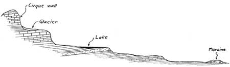
The floors of many of the park's major U-shaped valleys instead of having a more or less uniform slope, steeper near the head than farther down, as is usually the case in a normal stream valley, are marked by several steep drops or "steps," between which the valley floor has a comparatively gentle slope. Such a valley floor, throughout its entire course, is sometimes termed the glacial stairway. Most of the steps, particularly those in the lower courses of the valleys, are due to differences in resistance of the rocks over which the former ice flowed. On the east side of the Lewis Range, where the steps are especially pronounced, the rock strata of which the mountains are composed dip toward the southwest, directly opposite to the direction of the slope of the valley floors (Figure 1). Thus, as glaciers flowed from the center of the range down toward the plains, they cut across the edges of these tilted rock layers; where the ice flowed over weaker beds it was able to scour out the valley floor more deeply creating a "tread" of the glacial stairway. The more resistant rock formations were less easily removed, and the ice stream, in moving away from the edges of these resistant strata, employed its powers of plucking and quarrying to give rise to cliffs or "risers." Lakes dammed partly by the resistant rock strata now fill depressions scoured out of the weaker rock on the treads (Figure 1). These are rock-basin lakes, and where several of them are strung out along the course of the valley they are referred to as pater noster lakes because their arrangements resembles that of beads on a string. Well-known examples of such bodies of water are Swiftcurrent and Bullhead Lakes, two of the long series which stretches for seven miles between Many Glacier Hotel and Swiftcurrent Pass. Resistant layers in the lower portion of the Altyn formation, the upper part of the Appekunny, and the upper part of the Grinnell* normally create risers.
*For a brief description of these rock formations see Special Bulletin No. 3 (Geologic Story) of the Glacier Natural History Association.
|
| Figure 1. Idealized sketch of a glacial stairway from the arete at the center of the range to the Ice Age moraine at the mouth of the valley. |
The tributaries of glacial valleys are also peculiar in that they usually enter the main valley high above its floor and for this reason are known as hanging valleys. The thicker a stream of ice, the more erosion it is capable of performing; consequently the main valley becomes greatly deepened, whereas the smaller glacier in the tributary valley does not cut down so rapidly, leaving its valley hanging high above the floor of the major valley. The valleys of Virginia and Florence Creeks, tributary to the St. Mary Valley are excellent examples of hanging valleys. A splendid view of Virginia Creek valley may be had from Going-to-the-Sun Road near the head of St. Mary Lake. The valley above Bird Woman Falls as seen from Going-to-the-Sun Road just west of Logan Pass is a spectacular illustration of hanging valley. In addition there are many others, such as Preston Park, on the trail from St. Mary Valley to Piegan Pass; and the Hanging Gardens near Logan Pass.
|
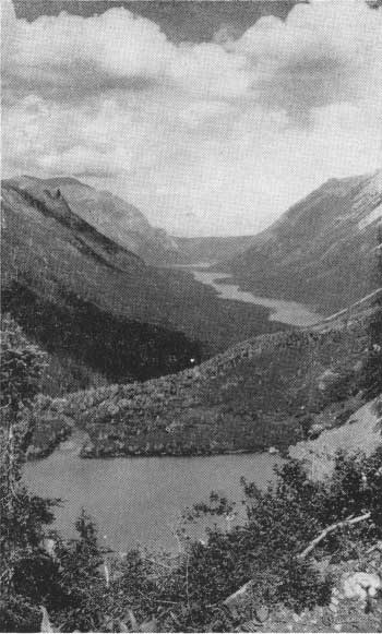
| TYPICAL GLACIAL VALLEY WITH CHAIN OF ROCK-BASIN LAKES. GLENN AND CROSSLEY LAKES IN DISTANCE; UNNAMED LAKE IN FOREGROUND RESTS IN A HANGING VALLEY AND ITS OUTLET DROPS SEVERAL HUNDRED FEET TO THE MAIN VALLEY. (HILEMAN PHOTO) |
Even more conspicuous than the large U-shaped valleys and their hanging tributaries are the long, sharp-crested, jagged ridges which form most of the backbone of the Lewis Range. These features of which the Garden Wall is one of the most noticeable, are known as aretes and owe their origin to glaciers. As the former long valley glaciers enlarged their cirques by cutting farther in toward the center of the range, the latter finally was reduced to a very narrow steep-sided ridge, the arete. The imposing height of the Garden Wall can readily be determined by using the layer of diorite as a scale. The conspicuous black band formed by the edge of this layer has an average width of 75 feet. So, from the porch of the Many Glacier Hotel a park visitor can readily see that the Garden Wall, even though five miles distant, is about 4,200 feet high. The height of other aretes can be just as readily obtained, for the band of diorite appears on the faces of most of them. In certain places glaciers on opposite sides of an arete nearly cut through creating a low place known as a col, usually called a pass. Gunsight, Logan, Red Eagle, Stony Indian and Piegan are only a few of many such passes in the park. At places three or more glaciers plucked their way back toward a common point leaving at their heads a conspicuous, sharp-pointed peak known as a horn. Innumerable such horn peaks occur throughout both the Lewis and Livingstone Ranges. Excellent examples near Logan Pass are Reynolds, Bearhat, and Clements Mountains. Other imposing horns are Split Mountain at the head of Red Eagle Valley, Kinnerly Peak in the Kintla Valley, and Mount Wilbur in Swiftcurrent Valley. The horn peak, because of its precipitous sides, is especially attractive to mountain climbers. The comparatively recent dates of first ascents on many park peaks attest to the difficulties they offer the mountaineer. Mount Wilbur, despite proximity to Many Glacier Hotel and camp, was unclimbed until 1923; Mount St. Nicholas succumbed in 1926, and the only ascent of Kinnerly Peak was made by several members of the Sierra Club in 1937.
|
| REYNOLDS MOUNTAIN AT LOGAN PASS—A TYPICAL HORN. (HILEMAN PHOTO) |
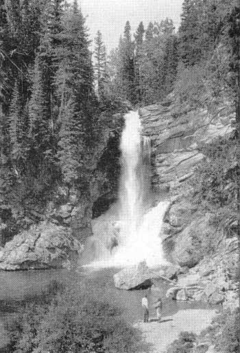
Another feature of the park which must be attributed partly to glaciation is the waterfall. There are two principal types, one which occurs in the bottom of the main valleys and one at the mouth of the hanging tributary valleys. The former, exemplified by Swiftcurrent, Red Rock, Dawn Mist, Trick, Morning Eagle and others, is located where streams drop over the risers of the glacial stairway. In other words, resistant layers of rock which the former glaciers were unable to entirely wear away give rise to this type of fall.
Examples of the hanging tributary type of fall which is due directly to the activity of the glaciers are Florence, Bird Woman, Virginia, Grinnell, Lincoln, and many others.
|
| TRICK FALLS IN THE TWO MEDICINE RIVER (GRANT PHOTO) |
No less conspicuous than the mountains themselves are the lakes. In most instances glaciers have been either directly or indirectly responsible for the origin of the several hundred in the Park. In general, these lakes may be divided into five main types, depending upon their origin.
(1) Cirque lakes. This type of lake frequently is circular in outline and fills the depression plucked out of solid rock by a glacier at its source. Some of the most typical examples are listed in the foregoing discussion of cirques.
(2) Other rock-basin lakes. This type, referred to above, fills basins created where glaciers moved over areas of comparatively weak rock. In all cases the lake is held in by a bedrock dam. A typical example is Swiftcurrent, which lies behind a dam of massive Altyn Limestone layers. The highway, just before it reaches Many Glacier Hotel, crosses this riser of the glacier stairway.
(3) Lakes held in by outwash. Most of the large lakes on the west side of the park fall in this category. The dams holding in these lakes are composed of stratified gravel which was washed out from former glaciers when they extended down into the lower parts of the valleys. Lake McDonald, largest in the park, is of this type.
|
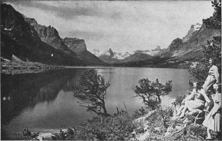
| ST. MARY LAKE LOOKING WEST. (HLEMAN PHOTO) |
(4) Lakes held by alluvial fans. St. Mary, Lower St. Mary, and Lower Two Medicine Lakes belong in this group. These bodies of water may have been rock basin lakes, but at a recent date in their history streams entering the lake valley have completely blocked the valley with deposits of gravel; thus either creating a lake or raising the level of one already present. St. Mary and Lower St. Mary Lakes probably were joined originally to make a lake 17 miles long. More recently Divide Creek, entering this long lake from the south, built an alluvial fan of gravel where it entered the lake. This fan was large enough to cut the lake into the two present bodies of water. The St. Mary Entrance Station at the eastern end of Going-to-the-Sun Highway is located on this alluvial fan, the form of which can readily be distinguished from a point along the road at the north side of the upper lake near its outlet.
(5) Moraine lakes. Most lakes with moraines at their outlets are partly dammed by outwash or rock ridges. The most spectacular example is Josephine Lake. The moraine which is partly responsible for the lake appears as a prominent hill, particularly when viewed from Many Glacier Hotel.
Another type of moraine lake, which occurs only at Sperry and Grinnell Glaciers, has already been mentioned. It differs from all other park lakes in having a glacier for part of its shoreline. There are two of these lakes at Sperry and one at Grinnell. Despite their small size, they are tremendously interesting, not only because of their relation to the glacier, but also because they are ordinarily filled with icebergs throughout the summer. Their surfaces often remain frozen until mid-summer.
There are several types of minor importance, the principal one of which is that formed by a landslide damming a valley.
One cannot remain long in Glacier National Park without noticing the varying colors of its lake waters. In fact this feature is so striking that ranger-naturalists probably are questioned more about it than about any other feature or phenomenon. To find the answer we must go again, as in so many instances, to the glaciers. As the ice moves it continually breaks rock fragments loose. Some of these are ground into powder as they move against each other and against the bedrock under the glacier. Most types of rock, especially the limestones and shales on which the park glaciers rest, when ground fine enough yield a gray powder. All melt-water streams issuing from glaciers are cloudy or milky from their load of this finely ground "rock flour."
Water from Grinnell Glacier is so laden with rock flour that the small lake along the edge of the ice into which the water pours is nearly white. Much of the silt is deposited in this lake, but enough is carried downstream to give Grinnell Lake a beautiful turquoise hue. Some of the very finest sediment which fails to settle in Grinnell Lake is carried a mile farther to Josephine Lake to give it a blue-green color. Even Swiftcurrent Lake, still farther downstream, does not contain clear water.
The rock flour which colors these as well as other park lakes can also be seen in the streams. Baring Creek at Sunrift Gorge (See p. 19 in Motorist's Guide) is milky with powdered rock from Sexton Glacier. Cataract Creek along the trail between Josephine and Grinnell Lakes is noticeably milky, extraordinarily so in mid-afternoon on very warm days. At such times melting of the glaciers is accelerated and more silt is then supplied to the streams.
Part of Sperry Glacier, in contrast to Grinnell, rests on a bright red shaly rock (known to the geologists as argillite) which yields a red-gray powder when finely ground. Hence the water in several small lakes adjacent to the glacier has a pinkish tint.
Although a large number of park streams are fed by glaciers there are many others, particularly in the south and west sections, which have no ice as their source. On a trail trip from Sunrift Gorge to Virginia Falls, one is certain to be impressed by the extreme clarity of the water in Virginia Creek. For half a mile below the falls the trail follows this cascading torrent from one crystal pool to another. So clear is the water that we are apt to mistake for wading pools places where the water may be five or more feet deep. Snyder Creek near Lake McDonald Hotel nearly rivals Virginia Creek in clarity. The sources of these two streams obviously are not melting glaciers.
From the foregoing discussion, it is evident that glaciers constitute one of the principal controlling factors in the color of the water in park streams and lakes. Where there are no ice masses streams are clear, and where glaciers occur the water possesses many shades varying from clear blue through turquoise to gray, and in rare cases even pink.
|
| MORAINE NEAR GRINNELL GLACIER IS 120 FEET HIGH. THE GLACIER EXTENDED NEARLY TO TOP OF MORAINE 50 YEARS AGO. (DYSON PHOTO) |
Although the former large glaciers of the Ice Age transported huge amounts of rock debris down the valleys of the park, the moraines which they deposited are, as a rule, not conspicuous features of the landscape. The Going-to-the-Sun Highway, however, crosses several accumulations of moraine in which road cuts have been made. The road traverses a number of such places along the shore of Lake McDonald. Because of the large proportions of rock flour (clay) in these accumulations, the material continually slumps, sometimes sliding onto the road surface. One of these cuts has been partly stabilized by a lattice-like framework of logs. The largest excavation in moraine along the highway is located about three miles east of Logan Pass just below the big loop where the road crosses Siyeh Creek. The surfaces of many boulders in this moraine are marked by grooves and scratches, imparted to them as they were scraped along the side of the valley by the glacier.
A small moraine is exposed along the exit road from the parking lot at Many Glacier Hotel. It contains a number of small red boulders, the sources of which are the red rock ledges in the mountains several miles up the Swiftcurrent Valley, plainly visible from the hotel.
One of these ancient moraines which, unlike most of the others, is a prominent feature of the landscape, consists of a series of mounds (25 to 100 feet high) extending from Swiftcurrent Cabin Camp down the valley on the north side of the road to a point near the entrance to Many Glacier Ranger Station. Some of the cabins are actually situated in a space between two of the highest mounds.
|
| LOOKING SOUTH ALONG THE GRINNELL GLACIER ICE FRONT. NOTE CREVASSES ALONG WHICH BERGS ARE BREAKING OFF. (DYSON PHOTO) |
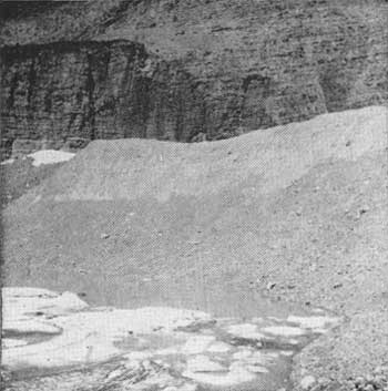
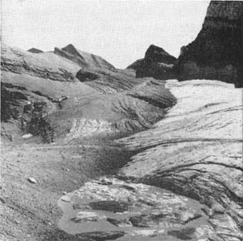
Surrounding all existing park glaciers are recent moraines varying in height from a few feet to more than two hundred. So recently have they accumulated that little or no vegetation is growing on them. They are particularly striking at Grinnell, Sperry, Blackfoot, Agassiz and Sexton Glaciers. On the last few yards of the spectacular Grinnell Glacier trail all persons who make the trip to the glacier must climb over the moraine before setting foot on the ice. From this vantage point on the highest part of this moraine the visitor can look down upon a huge crevassed mass of ice lying in a stupendous rock-walled amphitheatre, then merely by facing the opposite direction, he will see unfolded before his view one of the most colorful vistas in the Park. More than a thousand feet below in the head of a splendid U-shaped valley lies the turquoise gem of Grinnell Lake. A mile farther away the blue surface of Lake Josephine stands out in sharp contrast to the dark green of the spruce which lines its shores. High above he can see the red summit of Mount Allen carrying its white snowbanks into the deep blue of a Montana sky. Despite this magnificence the visitor must soon turn his attention to the tremendous accumulation upon which he stands, for it is no less interesting than the mountains and lakes. Among the many boulders which lie along the path are two prominent limestone blocks each 10 to 15 feet in diameter. The underside of one was grooved and polished as the ice pushed it across the rock surface underlying the glacier. The other, partially embedded in the moraine, has a polished upper surface because the glacier flowed over it for a time. Both these boulders, although now nearly 300 yards from the ice front, were covered by the glacier until about 20 years ago.
Because of shrinkage many of the glaciers are no longer in contact with these newer moraines. In some cases a quarter of a mile of bare rock surface intervenes between the moraine and the glacier which made it.
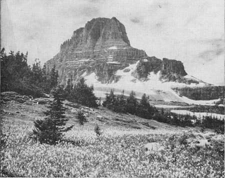
A few glaciers have disappeared within recent years, but their moraines remain as evidence of former glacier activity. One of the most notable examples is afforded by Clements Glacier, a small body of ice which existed until about 1938 in the shadow of Clements Mountain at Logan Pass. Its edge was bordered by a ridge-like moraine nearly a hundred feet high. Today, the trail from Logan Pass to Hidden Lake skirts the outside edge of the moraine. Should the hiker leave the trail and climb the few yards to the top of this moraine he could see it stretched out before him as a giant necklace encircling the base of Clements Mountain, but between mountain and moraine, where a few years ago the glacier lay, he will see only bare rock or drifted snow.
Despite recent rapid shrinkage of glaciers and the disappearance of some, Glacier National Park still is a land of ice, yet when the visitor views its present day glaciers and its sublimely beautiful mountain scenery he should not be unmindful of the powerful forces which, working during many thousands of years, have brought it all about. Then, and only then, can he properly appreciate the magnificence which Nature has so generously bestowed upon us.
|
| CLEMENTS MOUNTAIN AND GLACIER. THE GLACIER HAS SINCE DISAPPEARED. (HILEMAN PHOTO) |
| <<< Previous | <<< Contents>>> |
glac/gnha/2/sec5.htm
Last Updated: 11-Jul-2008