|
Theodore Roosevelt and the Dakota Badlands |
 |

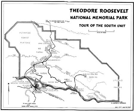
1957 Map of the South Unit of Theodore Roosevelt
National Memorial Park (renamed to Theodore Roosevelt National Park in
1978). (click on image for an enlargement in a new
window)
Features in the Park
Theodore Roosevelt National Park is of both scenic and historic interest. The rugged Badlands topography, the northern plains grasslands, and the Little Missouri and its tributaries remain today much as they were in the 1880's when Roosevelt visited there. Historical attractions of the park and its immediate vicinity are primarily places and structures associated with Roosevelt and his contemporaries. (The numbered paragraphs in the guide section correspond to numbers on the guide maps.) Web Edition Note: This description shows features accessible in the park during the late 1950's and early 1960's. Road alignment and intrepretive sites in the South Unit have changed since this was produced and park visitors should consult current park literature for visitor information to the South Unit.)

Horse roundup in the park, 1954. Courtesy
Osboro's Studio.
NATIONAL PARK—NORTH UNIT. A drive of 6-1/2 miles along the northern edge of this unit leads to a sheltered overlook. The colorful strata, varied topographic forms, and weird erosion patterns carved by the meandering Little Missouri River are everywhere. A sign gives brief information concerning the geology of the area. The grasses of the high plains, to the west of the overlook, and characteristic shrubs and trees will be of special interest to many people. The "Long X" 5-mile hiking trail, provides inspirational views of the meandering Little Missouri River and an opportunity to enjoy the primitive back country.

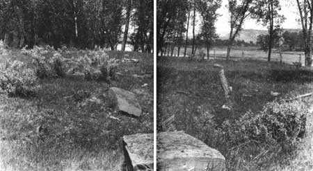
Site of Elkhorn Ranch, 1925. Courtesy
Russell Reid.
NATIONAL PARK—SOUTH UNIT. I. East Entrance Station. If west bound, you are invited to stop here before touring the park on visiting the old cattle town of Medora. There is a ranger at this entrance during the summer. Exhibits pertinent to Theodore Roosevelt and the early cattle industry are displayed inside the entrance station and at an adjacent parking area. Literature also is available at this point.

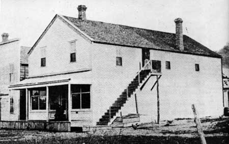
Joe Ferris store at Medora. Roosevelt had a room
here which he used whenever he stayed overnight in the town.
Courtesy Houghton-Mifflin Co.
2. Burning Coal Bed. From the main road a short distance inside the east entrance, a 4-mile back-country drive brings you to a burning coal bed. From its edge you can witness nature producing the type of rock known as "scoria," and can actually see one step in the processes that formed the rugged and eroded topography of the Badlands.
The scenic drive through the South Unit leads past many scenes that no doubt intrigued Theodore Roosevelt. Signs along the road call attention to Badlands formation, petrified wood, baked clay ("scoria"), lignite coal, and prairie dog towns, Two and a half miles from the east entrance a short spur leads to a parking area, the starting point of a self-guiding trail. On this trail you can identify the trees, shrubs, and flowers.
3. Old Lamb Ranch, 7 miles from the east entrance. Operated as the Peaceful Valley Dude Ranch from 1921 to 1931, this group of buildings—residences, office, shops, and assorted structures—until recently served as temporary park headquarters. The original Benjamin F. Lamb ranchhouse is of historical interest. Lamb was a contemporary of Roosevelt in the Badlands, operating a ranch here as early as 1885.
4. Beef Corral Bottom. At this site in 1884 the Marquis de Mores constructed a holding corral for the cattle to be slaughtered in his newly established packing plant in Medora on to be shipped from Medora to eastern markets. The circular corral was about 1,000 feet in circumference. A 130-foot wing assisted the cowboys in driving the cattle through the corral gate.

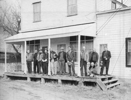
"Old-timers" of Medora and vicinity on the porch
of the old Ferris store, 1948.
5. Wind Canyon. A trail, guiding you along the rim of the canyon to an overlook above the river, tells the story of wind and water erosion in the Badlands.
6. Elkhorn Ranch Site, on the west bank of the Little Missouri River, 29 miles north of park headquarters. This was Roosevelt's "home ranch," completed in 1885. For several years after Roosevelt had abandoned his ranching operations here, he continued to maintain the ranchhouse as a hunting lodge. Following his visit to the place in 1892 he wrote his ex-foreman, Sewall: "The ranch-house is in good repair, but of course it is melancholy to see it deserted; I stayed there for several days." He may have visited the Elkhorn in 1893, but the next time he is known certainly to have been there was in 1896.
The fate of the old ranch buildings is a matter of speculation. Some claim they were swept away by the floods of the Little Missouri. The general consensus among the old residents of the Badlands is that neighboring ranchers hauled them away. By the time Roosevelt became President, the buildings had entirely disappeared. The only vestiges of the original structures at the Elkhorn site are the depression of the basement under the old ranchhouse, several foundation stones, the old well, and evidences of several outbuildings.
A drive of 29 miles over winding dirt roads, with several fords, will bring you to a point directly across the river from the Elkhorn Ranch site. If the river is low it can be waded. You should inquire at park headquarters regarding condition of the road and the river before undertaking this drive.
7. Johnson Plateau. A scenic drive past the Cottonwood Campground brings you to the grassy top of this plateau where you can view the surrounding butte country and the Little Missouri River valley.
8. Medora Overlook. This site overlooks the historic cattle town of Medora.

|

|
|
Last Modified: Sat, Jan 17 2004 10:00:00 am PDT |


