|
ZION
A Geologic and Geographic Sketch of Zion National Park |

|
Zion-Bryce Museum Bulletin
Number 3
A GEOLOGIC AND GEOGRAPHIC SKETCH OF ZION NATIONAL PARK
HISTORY
The Basket Makers—the earliest inhabitants of the southwestern United States whose archaeologic remains are sufficient to identify a culture—are represented in Parunuweap Canyon by fragmentary textiles woven in fiber, fur and feathers. The Cliff Dwellers (Puebloans), who followed the Basket Makers, occupied several sites in Zion Canyon and built villages in the Parunuweap Canyon 7 miles above its mouth. All the dwelling sites are small, and most of them doubtless were occupied only when crops of corn, beans, and squash needed attention. They seem to be outposts of much larger settlements south and east of the Colorado River, which attained a cultural peak about 1100 A. D. and left a notable record of excellence in architecture, village organization, and the making of pottery. In Zion National Park and adjoining areas the Puebloans were followed by the Piutes—linguistic relatives of the powerful Ute tribes that once dominated Colorado, Utah, and Nevada. The Piutes have always been peaceful clans who built no permanent houses but maintained settlements in the Virgin River Valley, which they called "Pah-roos" (muddy turbulent water), and its bordering plateau lands at places favorable for hunting deer, rabbits, lizards, and insects, for gathering grass seed and pinon nuts, and for cultivating small fields of corn. The Indians of southern Utah, numbering about 2,000 in 1860, are now represented by a few families supported by the Government on reservations near St. George and Moccasin Springs.
The first white men to visit southwestern Utah and probably the first within the state, were members of the Dominquez-Escalante expedition, who at the time of the American Revolution (1776) undertook an adventurous journey from the Spanish settlements at Santa Fe, New Mexico, to those at Monterey, California. Knowing that attempts to find a direct route between these ecclesiastical and military outposts of New Spain had been frustrated by futile efforts to cross the Colorado Canyon, Father Escalante followed trails that led northwestward through Colorado, thence westward to Utah Lake. In the lack of adequate information regarding a route to the coast, he abandoned the attempt to reach California and redirected his course southward. Passing by the sites of Beaver and Cedar City, he forded the Virgin River near La Verkin, traversed the Uinkaret, Kanab, and Kaibab Plateaus, and crossed the Glen Canyon of the Colorado at the place since known as the "Crossing of the Fathers." From the river he followed established trails back to Santa Fe.
Fifty years after Escalante's hurried trip through Utah, the region adjoining Zion National Park was explored by a company of about 16 men under the leadership of Jedediah S. Smith, one of the many fur traders whose activities make up much of the history of the West during the first half of the nineteenth century. In his search for pelts Smith left the outpost of the American Fur Co. on Great Salt Lake in August 1825 and in examining the streams along the base of the Wasatch Mountains discovered the Ashley (Sevier) River, which he followed some distance southward. Passing over the rim of the High Plateaus, he reached a southward-flowing river in the vicinity of St. George. This stream Smith named the "Adams River" in honor of President John Quincy Adams. In a report of a second expedition over this same route, in 1827, he renamed it the "Virgin River," presumably in recognition of the bravery of Thomas Virgin, a member of his party who was wounded in a fight with Indians.
Neither Escalante and the other Spaniards who followed this route nor Smith and other fur traders of his time saw Zion Canyon. These early travelers diverged little from the most feasible routes. The priests were interested in finding fields for religious propaganda; the trappers in finding "beaver country". Exploration of southern Utah resulted from plans made by the Mormon Church for the expansion of its economic, cultural, and ecclesiastical interests. Soon after the founding of "Zion" (Salt Lake City,) in 1847, scouts were sent forward across the High Plateaus and among the "southern mountains" to select sites where water and arable lands were available. Favorable reports from small settlements founded at Toquerville and Virgin City (1858) led to systematic colonization, beginning in 1861, when "several hundred" families moved from northern Utah to lands along the Virgin River. St. George (1861-62) was founded as the capital of this new empire, dubbed "Dixie Land" in the expectation that cotton planting would become the chief industry. The search for new lands suitable for irrigation farming resulted in settlements at Grafton, Rockville, and Springdale, on the immediate border of Zion National Park, and the discovery of the canyon known to the Piutes as Ioogoon (arrow quiver; "Come out the way you come in"). Guided by friendly Indians to the mouth of this canyon (Zion Canyon), Nephi Johnson penetrated the defile in November 1858 as far as the Great White Throne and perhaps to the Narrows. This first traverse by white men of a region later to be visited by thousands seems to have aroused little interest. A "narrow floor" enclosed by walls "too high and steep to climb" was just another among the scores of picturesque canyons sunk deeply into Markagunt Plateau. Its interest lay in the chance that its floor could be used for farming. With this possibility in mind, the canyon was rather thoroughly examined in 1861 by Joseph Black, who found suitable farm sites on the flat lands in front of Zion Lodge, upstream near the site of the Grotto Campground, and in Wiley Retreat. On these lands a few settlers cultivated corn, tobacco, garden vegetables, and fruit trees, and on the canyon floor and the plateau above they grazed cattle and sheep, until 1909, when the area was withdrawn as a national monument. An interesting episode in the canyon history was the installation of a wire conveyor to bring timber from the high canyon rims. The site of this enterprise is Cable Mountain.
The Mormon pioneers in the Virgin Valley were primarily farmers and stockmen—not artists, scientists, nor poets. Their energies were necessarily given to the absorbing task of providing the fundamentals of living. The marvelous landscapes seen from their fields and "herd grounds" were made known to the outside world by expeditions from Washington. During his second voyage down the Colorado River, in 1871-1872, Maj. John Wesley Powell, Civil War veteran and first explorer of the Grand Canyon, extended his scientific studies northwestward to the great cliffs that rim the High Plateaus. Members of his field party traversed the Parunuweap Canyon (pah-roon-weap; water that roars) and Little Zion Canyon, which Powell called "Mukuntuweap" (mu-koon-tu-weap; straight canyon). The description of these canyons and particularly the photographs by J. K. Hillers of the Gate to Zion, the Court of the Patriarchs, and Angels Landing for the first time called attention to the features that give Zion National Park its fame. In part contemporaneously with the work of Powell, Capt. George M. Wheeler mapped areas in southern Utah. In 1872 G. K. Gilbert traversed the North Fork of the Virgin (Mukuntuweap) from a point near its head to its junction with the East Fork (Parunuweap). The miles of canyon floor, in places less than 20 feet wide between sheer walls 2,000 feet high, he named "the Narrows—the most wonderful defile it has been my fortune to behold." (See Fig. 5.)
In mapping the Zion National Park country Powell and Wheeler were followed by Maj. C. E. Dutton, who in 1880 extended the surveys to include Kolob Terace (the high plateau into which Zion Canyon is sunk) and still higher plateaus farther north. Dutton's description of the Temples and Towers of the Virgin as seen from the east end of Smithsonian Butte is a classic in geologic literature, and the accompanying sketch by W. H. Holmes is a recognized masterpiece. (See Fig. 2.)
Dutton writes:
At our feet the surface drops down by cliff and talus 1,200 feet upon a broad and rugged plain cut by narrow canons. The slopes, the widening ledges, the bosses of projecting rock, the naked, scanty soil, display colors which are truly amazing. Chocolate, maroon, purple, lavendar magenta, with broad bands of toned white, are laid in horizontal belts, strongly contrasting with each other, and the ever-varying slope of the surface cuts across them capriciously, so that the sharply defined belts wind about like the contours of a map. From right to left across the further foreground of the picture stretches the inner canon of the Virgin ... Across the canon, and rather more than a mile and a half beyond it, stands the central and commanding object of the picture, the West Temple, rising 4,000 feet above the river. Its glorious summit was the object we had seen an hour before, and now the matchless beauty and majesty of its vast mass is all before us. Yet it is only the central object of a mighty throng of structures wrought up to the same exalted style, and filling up the entire panorama. Right opposite us are the two principal forks of the Virgin, the Parunuweap coming from the right or east, and the Mukuntuweap or Little Zion Valley, descending towards us from the north, now called the "Virgin River of Zion Park." The Parunuweap is seen emerging on the extreme right through a stupendous gateway and chasm in the Triassic terrace, nearly 3,000 feet in depth ... The flank of the east wall receding up the Mukuntuweap soon breaks into new forms much more impressive and wonderful. A row of towers half a mile high is quarried out of the palisade, and stands well advanced from its face. There is an eloquence to their forms which stirs the imagination with a singular power, and kindles in the mind of the dullest observer a glowing response. Just behind them, rising a thousand feet higher, is the East Temple, crowned with a cylindric dome of white sandstone; but since it is, in many respects, a repetition of the nearer West Temple, we may turn our attention to the latter. Directly in front of us a complex group of white towers, springing from a central pile, mounts upwards to the clouds. Out of their midst, and high over all, rises a dome-like mass, which dominates the entire landscape. It is almost pure white, with brilliant streaks of carmine descending its vertical walls. At the summit it is truncated, and a flat tablet is laid upon the top, showing its edge of deep red. It is impossible to liken this object to any familiar shape, for it resembles none. Yet its shape is far from being indefinite: on the contrary, it has a definiteness and individuality which extort an exclamation of surprise when first beheld ...
The towers which surround it are of inferior mass and altitude, but each of them is a study of fine form and architectural effect. They are white above, and change to a strong, rich red below. Dome and towers are planted upon a substructure no less admirable. Its plan is indefinite, but its profiles are perfectly systematic. A curtain wall 1,400 feet high descends vertically from the eaves of the temples and is succeeded by a steep slope of ever-widening base lending down to the esplanade courses below. The curtain wall is decorated with a lavish display of vertical moldings, and the ridges, eaves, and mitered angles are fretted with serrated cusps. This ornamentation is suggestive rather than precise, but is none the less effective ...
Nothing can exceed the wondrous beauty of Little Zion Valley, which separates the two temples and their respective groups of towers. Nor are these the only sublime structures which look down into its depths, for similar ones are seen on either hand along its receding vista until a turn in the course carried the valley out of sight. In its proportions it is about equal to Yosemite, but in the nobility and beauty of the sculptures there is no comparison. It is Hyperior to a satyr. No wonder the fierce Mormon zealot, who named it, was reminded of the Great Zion. or which his fervid thoughts were bent—"of houses not built with hands, eternal in the heavens."
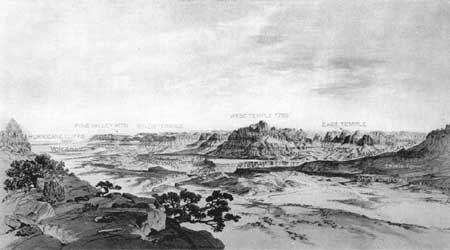
Figure 2. Panoramic sketch of the Zion Canyon region. Looking north
across Virgin River from the cliffs south of Rockville. Smithsonian
Butte in left foreground.
Though the grandeur and beauty of the Zion National Park region were thus pointed out by Federal surveys of 1870-80, the region was little visited during the next quarter of a century. Its remoteness from railroads and centers of population and the lack of roads by which it might be reached were handicaps not easily overcome. On the south it was cut off by the canyons of the Colorado, with no practicable crossing for more than 500 miles; on the west by the Nevada and Utah desert; and on the north and east by impassable cliffs and canyons. The only means of access even to its borders was a difficult road down Ash Creek (See Fig. 1) to its junction with the Virgin River and along that stream to the outpost settlements of Rockville and Springdale. The way into Zion Canyon itself was so rough and tiresome that only a few adventurous travelers visited it. But the increasing demand that the region be made accessible and its unique features preserved led to its establishment as a national monument in 1909. In 1918 the locally unpopular name "Mukuntuweap" was changed to "Zion," and in 1919 the area was made a national park. The assumption of Federal control opened the way for making the region accessible and for providing accommodations for visitors.
In 1923, with the building of a 30-mile spur of the Union Pacific Railroad from the main line to Cedar City, a wagon road was graded into Zion Canyon as far as Weeping Rock, and later this road was improved and extended as a modern automobile highway as far as the Temple of Sinawava, beyond which a mile long foot trail was constructed to the gateway of the Narrows. Access to the park from the east was provided by the Zion-Mount Carmel Highway. Begun in October 1927 and formally dedicated to travel on July 4, 1930, this road has many amazing features. The Pine Creek tunnel by which the canyon wall is penetrated is 5,607 feet long, ascends on a 5-per cent grade, and is bored just within the face of the cliff, through which opens six large windows or galleries that serve to light the tunnel and to give breath-taking views of the opposite walls. The west portal, 800 feet above the bridge across Pine Creek, is reached by a broad roadway that climbs by a 6-per cent grade on six switchbacks, attaining a length of 3-1/2 miles in an area 1 mile long by only a quarter of a mile wide. On leaving the east portal the road crosses a high concrete bridge, and 1-1/4 miles farther along it passes through a second tunnel 530 feet in length, beyond which it winds about spurs and towering walls along a picturesque, sharply meandering canyon.
The superb topographic map of the park made by the Geological Survey in 1929-1932 depicts a landscape of amazing variety and marks out roads and trails leading to points on the gigantic cliffs, canyons, and plateaus, and to restful springs and brooks. Of the many trails, the East Rim and West Rim saddle-horse trails are the most spectacular. They leave the floor of the valley at the foot of the Great White Throne and climb to the rims of the canyon a half mile higher, zigzagging up talus slopes, creeping along walls by half tunnels, threading through cool, dark, slit-like canyons, following ramps cut in the faces of cliffs, crossing bridges over narrow chasms, emerging upon the dome of the upper white cliff, and finally topping out among the pines on the Kolob Terrace.
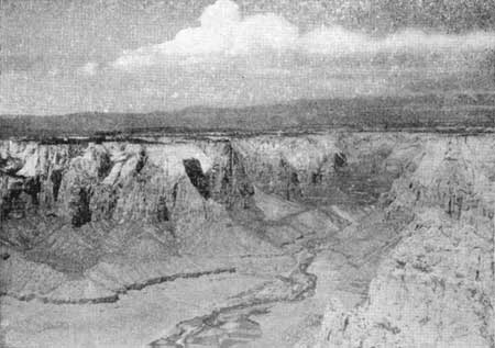
Figure 3. Gateway to Zion National Park. looking northeast along the
Virgin River. Middle foreground, Virgin River Valley at the village of
Springdale; middle distance, Kolob Terrace, a platform of limestone into
which have been excavated Zion Canyon and other gorges walled by
sandstone (White Cliffs); background, slopes and cliffs of sandstone,
shale, and coal (Gray Cliffs); on the sky line, cliffs of limestone
(Pink Cliffs) of the Markagunt Plateau. The altitude of Springdale is
3,900 feet; of Markagunt Plateau 9,000 to 11,000 feet.
Zion Canyon seems always to have been viewed with reverence. Somehow its grandeur and beauty inspire worship that in turn brings a feeling of peace. To the pioneers of the early sixties Zion (Salt Lake) was here represented by "Little Zion," and the man-made temple at the Mormon capital by the natural temples of the canyon. In keeping with this attitude, names of religious significance bestowed by devoted visitors before the park was established have been retained and others of like purport added. The spirit of reverence is reflected in such names as the Watchman, the Altar of Sacrifice, the Three Patriarchs, the Great White Throne, Angels Landing, the Organ, and the Temple of Sinawava.