|
FORT SUMTER National Monument |
 |

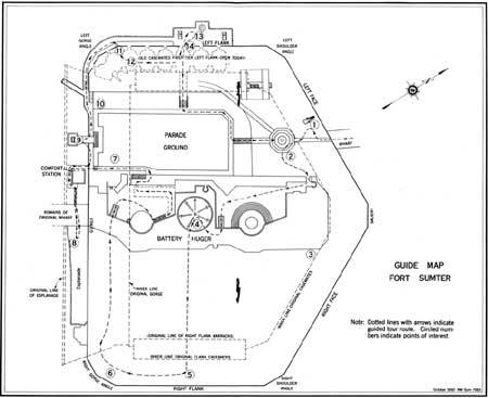
Guide Map of Fort Sumter.
(click on image for an enlargement in a new window)
Guide to the
Area
The visitor to Fort Sumter today enters on the left face of the fort, near the salient, at an elevation approximating the floor level of the original second tier of casemates. Directly ahead is the flagpole monument to Maj. Robert Anderson. Beyond the flagpole, stairs lead down to the fort parade ground, now but one-quarter of its original extent and 5-1/2 feet higher. At the far end of the parade, a raised sidewalk marks the exterior of the gorge, or rear wall of the fort. The huge concrete structure at the left of the parade is the emplacement for Battery Huger, a battery of two long-range seacoast guns erected in 1899. The earth and masonry embankment at the right of the parade is the ruin of the left flank. A wooden gatehouse at its center, halfway down the parade, marks the entrance to a modern passageway leading to the old casemates of the left flank.
The following guide to points of interest in the area should be used in conjunction with the map on pages 22—23. Numbers on the map correspond to numbers in the text below.
1. RODMAN GUN. Fifteen-inch smoothbore gun. Part of Fort Sumter's post-Civil War armament.
2. THE FLAGPOLE MONUMENT. Monument to Major Anderson and his garrison, erected under bequest of Major Anderson's daughter, Eba Anderson Lawton, accepted by act of Congress, approved May 11, 1928. The inscription at the base of the flagpole reads: "In honor of Major Robert Anderson and the 128 men of his command who for 34 hours April 12—13, 1861, withstood the destructive bombardment of Fort Sumter and withdrew with the honors of war. The War of Secession began here." The figure "128" includes the 43 workmen who helped man the guns during the bombardment.
3. THE RIGHT FACE. Guns mounted in the lower tier of the right face duelled with Fort Moultrie in the initial attack, April 12—13, 1861. Since the right face was so situated as to escape "broadsides" from the Federal batteries on Morris Island, 1863—65, its outer wall remained at nearly full height in February 1865. After Fort Sumter was silenced in August 1863, the Confederate garrison mounted three guns in the first-tier casemates just above the right shoulder angle. This was the "Palmetto Battery," called thus because of the protective log cover raised on the exterior. For several months this battery was the sole armament of the fort. All the lower tier casemates of this face were reclaimed in the seventies and armed with "100 pounder" Parrott rifled cannon. These guns, rusted and worn, were buried with the casemates just before Battery Huger was constructed.
4. ORIENTATION POINT. The visitor stands at this point atop Battery Huger, almost in the center of old Fort Sumter. On either side are the emplacements for the 12-inch guns of Battery Huger. The grass-covered area stretching out to the right flank wall is earthen fill, the height of which averages 20 feet above the original parade ground. Markers erected at the ends of directional arrows give relevant information on Forts Johnson and Moultrie, Morris Island, the "Swamp Angel," and Charleston. In the center of the area there is a model of Fort Sumter, oriented exactly with the fort.
5. THE RIGHT FLANK. This wall bore the brunt of the (Federal) "iron clad" attack of April 7, 1863. The great bombardments that followed almost completely destroyed it. By the end of the war, the right flank had become an irregular ruin 25 to 30 feet above low water, shored up on the interior by a timber "blockhouse" built by the Confederate garrison in preparation for expected invasion. The outer wall of the right flank was partially rebuilt following the war.
6. RIGHT GORGE ANGLE. From a gun in the first tier of casemates, Capt. Abner Doubleday fired the first shot from Fort Sumter, April 12, 1861. Also in this section of the fort occurred the deepest penetration of Confederate shot and shell in the initial attack. In part, this was the work of the Confederates' rifled gun, the first rifled gun fired in action in America.
7. THE GORGE. The row of bricks in the parade ground marks the original inner limit of the gorge, or rear wall of the fort. The raised sidewalk at the end of the parade marks the line of the outer wall. As is evident, most of the gorge was destroyed by the Federal bombardments of 1863—65. Originally designed to house officers and their families, living quarters replaced here the gunrooms that lined the other walls of the fort. At each end of the gorge, on both casemate tiers were the fort magazines. The gorge was armed with only one tier of guns. These were mounted on the open "terreplein" (earthen platform) below the parapet of the outer wall and behind the third floor of quarters.
8. ESPLANADE. A 25-1/2-foot-wide promenade and landing-space which lined the full length of the gorge exterior, at its base. Out from the center of the esplanade ran the original stone wharf 171 feet long. Through the gorge, at the head of the wharf was the original sally port (gateway) of the fort.
9. GARRISON MONUMENT. Monument "in memory of the garrison defending Fort Sumter during the bombardment April 12—14, 1861" erected by the United States Government in 1932. The roster of the original garrison is listed on the tablet.
10. ENTRANCE TO MAGAZINE. This arched passageway connected the two magazines at the western extremity of the gorge, on the first tier. Originally, there were two other magazines above these, and a similar arrangement at the opposite extremity of the gorge.
11. SIDE POSTERN. Side entrance to the fort. Designed to permit access to the water by the enlisted men in the barracks on the left flank interior. Note the narrow, wedge-shaped bricks in the arch overhead.
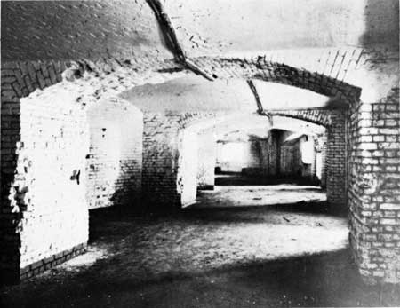
12. THE LEFT FLANK CASEMATES. These casemates (gunrooms) of the lower tier of the left flank are the only casemates of the original fort open to the visitor. Originally, these rooms were surmounted by a second tier identical in appearance. On the open "terreplein" above that tier, the "barbette" tier of guns was mounted. This was the over-all arrangement followed on the right flank, and along the two faces. Each of the casemates was designed for the mounting of a gun, crosswise, to fire through the embrasures in the outer wall. Guns mounted in the angle next to the gorge exchanged shots with Fort Johnson during the initial attack, April 12—13, 1861.
Shielded (by the mass of the gorge) from the Federal guns on Morris Island, 1863—65, the left flank casemates were used as Confederate head quarters and hospital during that time. The lower half of the outer wall retained its full height at the end of the siege, but was leveled to approximately half that height during the 1870's. The sally port through the center of the left flank is not original; it was constructed after the war to replace a gun embrasure.
13. GUNS, LEFT FLANK EXTERIOR. Two 13-inch mortars and one rifled-and-banded "42 pounder" are mounted outside the modern sally port on the left flank. The "42 pounder" may have been part of Fort Sumter's Civil War armament; at least, types like it were used in the casemates by both Union and Confederate garrisons. The mortars were types used against the fort by Federal troops on Morris Island, 1863-65.
14. PLAQUE HONORING CONFEDERATE DEFENDERS. On the left flank wall, near the (modern) sally port. Plaque erected by the Charleston Chapter of the United Daughters of the Confederacy in 1929 "In reverential memory of the Confederate garrison of Fort Sumter who during 4 years of continuous siege and constant assaults from April 1861 to February 1865, defended this harbor without knowing defeat or sustaining surrender."

The case mates of the Left Flank, first tier, today. These are the
only casemates now open.

|
|
Last Modified: Mon, Dec 2 2002 10:00:00 am PDT |


