|
JAMESTOWN National Historic Site |
 |
Guide to the Area (continued)
The tour route emerges from the Confederate earthworks near the entrance to the church and passes again near the Smith, Pocahontas, and House of Burgesses markers and other memorials. Just beyond, the tour leaves the Association grounds (the west end of the site of old "James Towne") and follows a walk close to the bank of the river. Beyond, stretches the eastern section of "James Towne."
It has become possible to define on the ground the pattern of Jamestown as it existed in at least a part of the early period. Utilizing the route of the "Greate Road," "Back Streete," "the highway close to the river," and various connecting ways, a plan now lays on the ground east from the Visitor Center. Exposed original foundations, other ruins marked aboveground in brick and wood (these in dull white), reopened old ditches (which often mark property lines), fences of period type, and replanted hedges are all used. Paintings help in visualizing the houses that once stood on some of the foundations while recorded descriptions, narrative markers, and other aids give information on owners, events, and happenings.
The extreme east end of Jamestown is that area developed after 1619, first actually surveyed by William Claiborne in 1623, and known to its first residents as New Towne. Here it is possible to locate, plot, and identify, with some assurance, a number of the early property holdings.
There is the plot taken up by Capt. John Harvey in 1624, on which he had houses and where he kept a garden and cultivated fruit trees. Across "Back Streete" from the Harvey site was the holding of Dr. John Port who was sent from England in 1621 accompanied by two surgeons and a chest of medicine. He had a house here by 1622, although it was not until after this date that he obtained his land patent.
West of the Harvey site was the home and lot of George Menefie, an attorney, administrator, and member of the council. Near the home of Menefie was the tract of Ralph Hamor, Dale's secretary of state, who died in 1626. Farther west were the holdings of John Chew, a merchant (1624), and of Richard Stephens (1623), who had personal difficulties with John Harvey, and who later appears to have been a party to the first duel fought in an English colony. North of the "Back Streete" and west of Port's holdings were those of Edward Blaney (a merchant), Capt. Roger Smith, and Capt. William Pierce, whose house George Sandys, in 1623, pronounced "the fairest in Virginia."
Near the river, in the "New Towne" section, stood the First State house (14) in Virginia. Foundations here (now partly exposed and partly marked) are thought to be those of this significant structure. It served the colony from 1641 to 1656. In it, during the early governorship of Sir William Berkeley, were discussed the measures needful for the government of the growing colony. Here, too, the colony gave its submission to the commonwealth government of Oliver Cromwell in England in 1652, and Richard Bennett was chosen as governor by the assembly to succeed Berkeley.
Even the designation "New Towne" was forgotten in the years after 1650 when the area, including street alinement, changed considerably. Those living in houses here or owning property in Jamestown's east end then included Sherwood, Thomas Rabley, James Alsop, Richard Holder, William Edwards, and Henry Hartwell, one of the founders of the College of William and Mary. The scanty remains of Hartwell's Frame House (15) are believed to have been identified and they are marked. In this instance the discovery of a preponderance of "H-H" initialed wine bottle seals furnished a helpful identity clue.

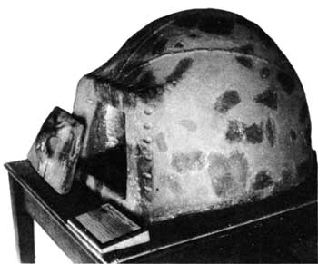
An early baking oven of clay reconstructed from
fragments found in the excavations at Jamestown.
The "Country House" (16) in this early period lay in the "New Towne" section. Perhaps a number of houses stood here on the same site prior to the first brick structure that bears this designation. In excavations on the site, the foundations of the brick building were found, including excellent specimens of ornamental plaster which may have adorned this structure or that of a later private residence of William Sherwood, which was found to have occupied the same site. Its foundations are visible.
Dominating the scene today in this area are the ruined walls of the Jaquelin-Ambler House (17). These are a testimony of the late colonial period (18th century) when Jamestown Island was no longer the seat of government and when, as the town declined, the island became the private estate of two families—Ambler and Travis. The present walls of the Ambler House constitute the center portion of a rather impressive residence that was flanked by two wings. It was begun about 1710 and when fully established, had formal gardens, the brick walls of which were partly uncovered during archeological work on the townsite. Its construction is thought to have obliterated all trace of Richard Kemp's house, the first recorded all-brick house in Virginia.

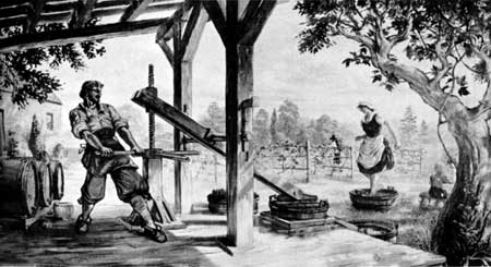
Winemaking as it may have been practiced at
Jamestown three centuries ago. (A painting by Sidney E.
King.)
Between the Ambler House ruins and the Visitor Center stood a "long house" (18), one made of several sections with common connecting walls. Its long walls have been outlined on the ground as it stood some three centuries ago. Behind this site are the original ruins (displayed under cover) of an early building that appears from its fireboxes and other features to have served some, but as yet unidentified, "manufacturing" purpose. Near it, unmistakeable evidences of pottery manufacturing have been found. This particular locality has evidences, too, of other types of workmanship. Perhaps, for a time, it was a kind of "Production Center" (19) in Jamestown.
The story of Jamestown is not all concerned with the townsite itself. Much of it deals with farming and other activities on the island surrounding the town except on the river front, and especially to the east. The Island Drive is a motor road that gives access to this island area. Starting from the central parking area, it traverses the island's 1,559.5 acres of marsh and woodland. The full drive is about 5 miles although it has a shorter 3-mile loop. Natural features are named and markers carry legends about the land and the people. Large paintings here and there picture the life of the times in daily activities such as winemaking, tobacco-growing, and lumbering. After passing the Confederate Fort (20), you come to Black Point (21) at the east end of the island where there is an excellent view of the lower reaches of the James River. Then the loop takes you past the Travis Graveyard (22) and The Pond (23), where Lawrence Bohun collected herbs for medical experiment in 1610.
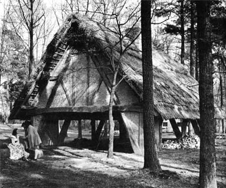
The one-way tour road loops back to the parking area and to the isthmus connecting the island and Glasshouse Point on the mainland, so named because the colonists, in 1608, undertook to produce glass at this location. Here are exhibited the Original Glass Furnace Ruins (24) the remains of the first attempt to produce glass in America. Nearby is a Working Furnace (25) of the same type housed in a thatch-covered building constructed in the manner of those used in Virginia and Eng land three and a half centuries ago. The Jamestown Glasshouse Foundation, Inc., representing a number of leading American glass companies, helped to make this possible. The Foundation operates the furnace and in season the blowing of glass in the old way can be observed. Hand made glass objects can be purchased.
The tour of Jamestown ends here at the "Glasshouse" From this point the Colonial Parkway leads to Williamsburg and Yorktown. Following this route you can read history on the spot in the order it occurred.

A building, such as may have been used in
1608—09, houses the glass making exhibit on Glasshouse
Point.

|
|
Last Modified: Mon, Dec 2 2002 10:00:00 am PDT |


