

|
BANDELIER National Monument |
 |
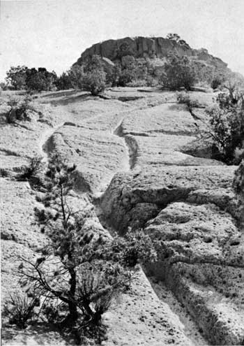
Trail worn into the rock, near Tsankawi
Ruin.
Principal Ruins of the National Monument
TSANKAWI. The Otowi house-group occupies a site atop a low ridge walled in by the cliff sides of steep Pueblo Canyon. Its nearest neighbor, Tsankawi, is sited on a very different terrain: Tsankawi is very near to being a "sky-city" in the style of the modern Acoma in western New Mexico. Not as large as Otowi, this ruin has equal majesty by reason of its commanding position on top of a cliff-ringed island mesa overlooking a vast north-south sweep of the Rio Grande and the Sangre de Cristo Mountains beyond. The location and the ground plan suggest defense as a first consideration. Of masonry construction in a rough hollow square, Tsankawi would have presented a serious problem to enemy besiegers. On the other hand, a siege would have cut off the defenders from their water supply, far in the canyon below. There is, however, some evidence of a rain-catchment basin close outside the eastern walls, and excavation may in future confirm the existence of an ingenious water-storage system.
The most memorable sight at Tsankawi lies along the trail that climbs from the end of the access road to the mesa-top. Here for 100 yards the path, crossing a bald slope of soft gray tuff, is worn down for almost 18 inches by the climbing and descending feet of thousands of Indian passersby. Granted that the rock is extremely porous and soft, it is nonetheless almost beyond the scope of imagination to conceive the vast traffic required to so entrench the path. Today, when you climb this trail, you cannot but visualize a procession of Indian farmers over several generations traveling to and from their fields, their sandaled feet scuffing each year a fractional inch deeper into the calendar of the rock.

|

|

|
Last Modified: Sat, Jan 6 2001 10:00:00 am PDT |