

|
GOLDEN SPIKE National Historic Site |
 |
This was the land they had to cross:
Sierra Nevada, Rockies' slopes,
Plains, deserts, basins,
Land of the Indians.
The land has little changes its face:
Mountains as rugged, plains as wide,
Deserts dry as a century ago.
Only the Indians changed.
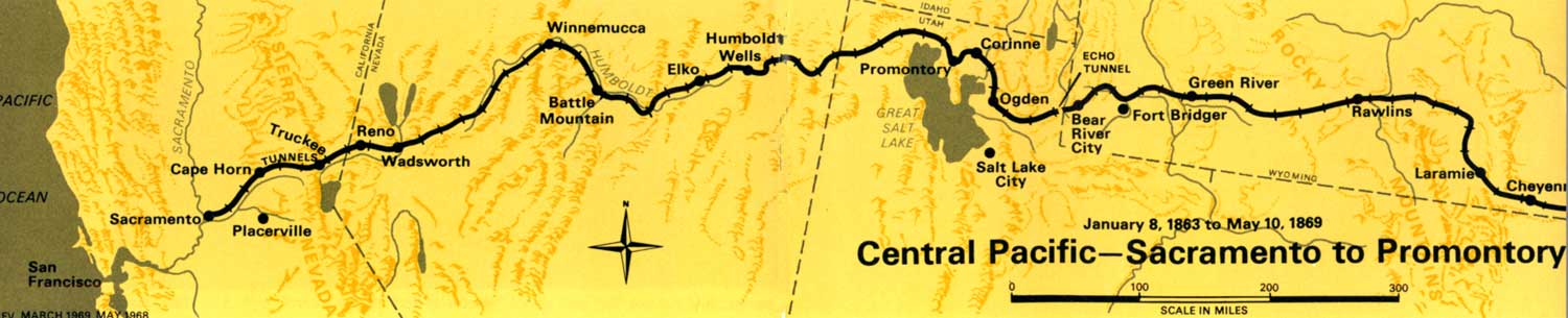
Progress of the Central Pacific
Although the Central Pacific laid its first rail more than a year before the Union Pacific, it encountered its toughest work—the crossing of the Sierra Nevada—almost immediately. The rails reached Newcastle, 31 miles from Sacramento, on June 4, 1864. For the next 4 years, with numerous delays produced by financial, political, topographical, and weather problems, the C.P. labored to surmount the Sierra. The mountains presented enormous engineering obstacles to overcome in the face of severe weather. Deep fills, rock cuts, high trestles, snaking grades, and 15 tunnels totaling 6,213 feet through solid granite proved necessary. To protect the track from snowslides, 37 miles of wooden snowsheds and galleries had to be built.
Recalling some of the difficulties, Construction Superintendent Strobridge testified:
During the winter of 1866 and 1867 and the following winter of 1867 and 1868 there were unusually heavy snowfalls in the upper Sierra Nevadas. . . . The tunnels were got under way with as large a force as could be used on them and the remainder of the force was sent to the Truckee Canyon on the east slope of the Sierras, where the snowfall was not so great as to entirely prevent grading during the winter, the total force being about 13,500 men at this time. The snow was so deep that it was impossible to keep the tunnel approaches clear and we were compelled to make tunnels through the snow from the dump to the tunnel entrances. Snow tunnels were also required to get into camp. In many instances our camps were carried away by snowslides, and men were buried and many of them were not found until the snow melted the next summer. In the spring of each year the men were taken back from the Truckee into the mountains and an average depth of ten or twelve feet of snow was cleared away before grading could be commenced.
The total snowfall of the season was about forty feet, and the depth of hard, settled snow in midwinter was eighteen feet on a level in Summit Valley and Donner Pass, over which we hauled on sleds track material for forty miles of railroad, three locomotives, and forty cars from Cisco to Donner Lake, where all was reloaded on wagons and hauled over miry roads to Truckee, a total distance of twenty-eight miles, at enormous cost. [Thus] the road was forced to the east slope of the Sierra Nevadas. . . .
The line was opened to Clipper Gap, 43 miles from Sacramento, on June 10, 1865; to Colfax, 55 miles, on September 10; to Dutch Flat 68 miles, in July 1866, and to Cisco, 94 miles, on November 9. Here end-of-track remained while thousands of coolies blasted in the Summit Tunnel. The tunnel was 1,659 feet long, and, during the year that work on it stopped end-of-track, other crews toiled at grading and track laying on the east slope. After completion of the tunnel in August 1867 the gap quickly closed, and the first train steamed into Truckee on April 3, 1868. The tracks reached Reno, Nev., 154 miles from Sacramento, on June 10, 1865, and Wadsworth, 189 miles, on July 22.
The Central Pacific had put the roughest part of the job behind it. Ahead lay the Nevada desert and conditions were favorable for rapid progress. Even so, the Union Pacific was far advanced. In May 1868 it had reached Laramie, Wyo., 537 miles west of Omaha. It had laid 348 more miles of track than C.P., but ahead lay the Wyoming Black Hills and, across the Wyoming Basin, the Wasatch Mountains.
(click on image for an enlargement in a new window)

|

|
Last Modified: Sat, Sep 28 2002 10:00:00 pm PDT |