

|
ORGAN PIPE CACTUS National Monument |
 |
The Land and Its Forms
TIME AND CLIMATIC forces have long been at work here sculpturing the earth to form today's scenery and providing soil, slope, and exposure for plantlife. Topography within the monument, typical of southwestern Arizona, is characterized by short, northerly trending mountain ranges separated by wide, nearly level valleys, or basins. Mountain slopes are rugged and precipitous, with surface rock bare or covered with only a veneer of talus. There are few seeps and springs and no permanent streams in the entire monument. Nevertheless, during hundreds of centuries, intermittent streams caused by periodic rains, particularly the sometimes torrential cloudbursts of summer, have carved the mountains, molded alluvial fans, and built the gently sloping outwash plains, or bajadas, spreading out along the mountain bases.
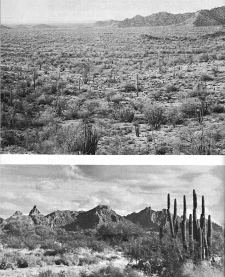 The Agua Dulce Hills (above) are the heavily eroded, granitic remnant of a very old range. Thick layers of volcanic material compose the Ajo Mountains (below). |
The Ajo and Growler ranges are part of the extensive Basin and Range physiographic province of western and southwestern United States and northern Mexico. These ranges were caused by immense block-faulting that created sharp, staggered ridges with deep valleys between. The diagrammatic drawing below shows this original formation. Valleys between ranges are not the result of wearing away by stream-cutting but, on the contrary, they are troughs partly filled with debris eroded from the mountains and deposited by sheet erosion and ephemeral streams.
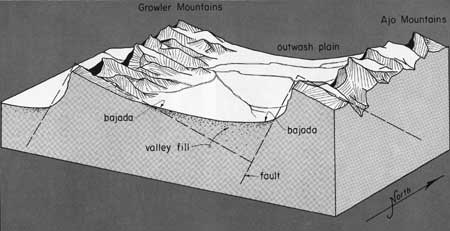
Now knee deep in the outwash of their own debris, desert mountain ranges have built sloping alluvial fans of rocks and gravel around canyon mouths. These fans join to form continuous, slightly sloping aprons, or bajadas, of finer materials that have been deposited farther out. Toward the centers of the valleys are wide, nearly level plains of clay and silt which may be hundreds of feet deep in places.
Sudden but brief storms drop a considerable volume of water on the mountains within the monument. Most of this runoff passes west and northward by means of a system of arroyos and sandy washes into the usually dry bed of the Gila River. About one-fifth of the monument area drains south into the Sonoyta River of Mexico, thence toward the Gulf of California. These well-defined drainage systems indicate that a long time has elapsed since the occurrence of earth movements that gave rise to the present surface features.
Mountains in the monument are of two types—the mesas, with broad, nearly flat summits capped with lava; and the sierra type, with knife-edge ridges and pointed summits. Slopes of the latter are precipitous, and canyons are more open than those of the mesas. Maturely eroded ranges are generally bordered with outwash aprons, while the mesalike, lava-capped mountains are not.
Geologists tell us that at some time during the Paleozoic era (180 to 510 million years ago) this region settled beneath the sea and remained there until the beginning of Permian time. During the following 120 million years of the Mesozoic era, this area was probably land. About that time molten lavas invaded the deep buried bedrocks, cooling slowly to form granite. (For ages of the geologic formations and rock units, see table below.)
Ages of formations and rock units, Organ Pipe Cactus National Monument1
| Formation or rock unit | Geologic age | Approximate age in millions of years |
| Alluvium fill | Recent and Pleistocene | Present to 1 |
| Younger volcanics | Pleistocene and Pliocene | 1 to 10 |
| Daniels conglomerate | Middle Tertiary | 10 to 40 |
| Older volcanics | Middle Tertiary | 10 to 40 |
| Intrusive rhyolite | Early Tertiary | 40 to 60 |
| Younger "granite," and ore deposits ascribed to its influence. | Early Tertiary | 40 to 60 |
| Older "granite" and schist | Middle and Late Mesozoic | 125 to 180 |
| Sedimentary series | Paleozoic | 180 to 510 |
| Cardigan gneiss | Precambrian | More than 510 |
|
1From Butler, B. S., and J. V. Lewis, Mineralization in the Organ Pipe Cactus National Monument, Arizona, 1940. Unpublished manuscript, available in open files at National Park Service, Southwest Regional Office, Santa Fe, N. Mex. | ||
Somewhat later, a new invasion of molten materials pushed closer to the surface, forming "Tertiary granites." Cooling magmas separated into solutions that produced the mineral deposits at Ajo and elsewhere. Grayish-white rhyolite dikes and intrusions associated with this early Tertiary activity are noticeable in the Growler Pass area and include outcroppings of black, gray, and green obsidian (volcanic glass).
During the middle and late Tertiary period, violent volcanic activity took place in the vicinity. Surface eruptions resulted in the formation of two great series of volcanic rocks (andesitic tuffs and breccias, and lava flows), which are the dominant rocks composing the major mountain ranges of the monument today. Earth movements ending about the close of the Tertiary period (perhaps extending into the Pleistocene) brought about the great displacement of earth blocks that roughly outline the present mountain ranges, as well as the depressed areas between them.
Geological history, then, recounts that the Sonoyta Hills, the Quitobaquito Hills, and outcroppings along the southwestern foot of the Dripping Springs Range and also near Growler Pass are remnants of ancient schists, gneisses, and granites, more recently uncovered by erosion. The granites resulted from slow cooling of intrusive Precambrian or Mesozoic magmas. The schists and gneisses are ancient rocks probably of varied types which have been changed, or metamorphosed, to their present forms.
The Puerto Blanco, Growler, and Ajo Mountains are composed of thick layers of volcanic materials that were poured out during the series of great Tertiary lava flows and were later lifted by block faulting. Erosion continuing since that time has worn down these mountains, cutting canyons in their slopes and depositing the debris in the depressions between ranges, thus forming the wide, nearly level Ajo, Sonoyta, La Abra, and Growler valley plains.
A few small, widely scattered centers of mineralization developed in connection with the early molten intrusives. Silver, lead, and some gold were found along outcroppings of these very old rocks in the southern and southwestern base of the Puerto Blanco Mountains. Other mineralized pockets, principally containing copper, occur in outcroppings of the old rocks near Growler Pass in the northwestern part of the monument and at Copper Hill in the northeastern part.
The only well-bedded sedimentary rocks recorded within the monument are layers of shale (probably Paleozoic) sandstone, limestone, and a bouldery limestone conglomerate which have been generally metamorphosed by heat from the volcanics into phyllite, quartzite, and marble, respectively. In the process of alteration, these rocks were rendered more resistant to weathering, and hence their outcrops form prominent ledges.
These very old sedimentary deposits occur along the extreme northern border of the monument about 1 mile north of Growler Pass and in low hills at intervals for 3 miles farther north. No fossils have been found in rocks within the monument, those once contained in them having been destroyed during the process of alteration. Some fossils do occur in the limestone boulders of the Locomotive fanglomerate outcropping in the Growler Mountains north of the monument.
Rocks of the earlier volcanic action constitute the greater part of the mountain masses. They form cliffs and precipitous slopes even where they have been covered by flows of more recent lavas. Within the monument, these volcanic rocks occupy some 90 square miles of the surface. They make up the greater part of the Ajo and Dripping Springs ranges, and also the northwestern part of the southern Growler Mountains.
These older volcanics include a wide range of eruptive materials, the most prominent of which are the andesitic tuffs and breccias and the brown and purplish-brown flow-lavas which are increasingly prominent toward the top of the series.
Younger flows of basaltic andesite and basalt cover many of the older volcanic rocks. The most extensive and youngest lava deposit within the monument is the capping that covers the greater part of the southern range of the Growler Mountains, almost 30 square miles in area. Generally, it rests on the eroded surface of earlier volcanics, and in places it overlaps other old formations. Erosion has removed this cover from earlier tuffs and lavas in a rugged, pinnacled area of 2 or 3 square miles immediately south of Bates Well.
Even the youngest volcanics have been faulted and in some places deeply eroded. They are nearly everywhere tilted somewhat, and at many places they are overlapped or buried by alluvium to depths of several hundred feet. Much of the lava forming both the older and younger flows probably rose to the surface through fissures, for no volcanic plugs or other evidences of vents of former volcanoes have been found within the monument.
Between the widely separated mountain ranges lie broad alluvial plains, or valleys. These deposits, made up of enormous quantities of material eroded from the mountains, vary in character with the types of rocks from which they were derived. In general, the texture of the alluvium changes with the distance that water has carried it from the mountains. Large boulders are most numerous near the mouths of canyons; smaller boulders and pebbles dominate farther out; and sand, silt, and clay are found mainly in the lower and flatter central areas of the plains. The coarsest material maintains the steepest slopes, whereas the finer silts and clays have built up surfaces that are nearly level. Much of the alluvium is thought to have accumulated during Pleistocene times, but some of the deeper basin fills may date back even to the Pliocene. The process of erosion which carries debris from the mountains out into the valleys is, of course, continuing and will keep on as long as there are mountains and running water to erode them.

|

|

|
|
|
Last Modified: Sat, Nov 4 2006 10:00:00 pm PST |