|
|
By Emery C. Kolb*
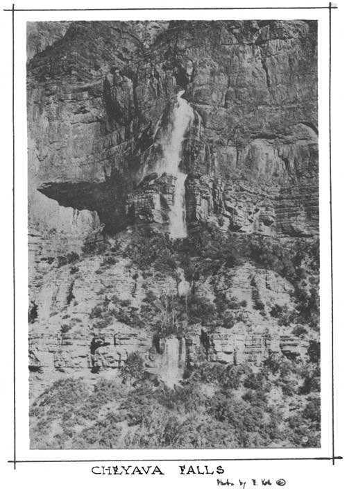
AS early as 1902, vague rumors were heard of the mysterious roaring of Thunder River far below the western end of the Kaibab Plateau. That the prospectors and miners who circulated the reports never mentioned a similar roaring of the Cheyava Falls at the head of Clear Creek to the east, is probably due to the fact that during the long winters, cold weather and blankets of snow always drove both animals and men to lower levels towards the north. These elements likewise prevented their return until after the heavy thaw and therefore after the subsidence of the greater part of the spring run-off. The Cheyava Falls, which gush out of the upper part of the Blue Lime Wall (Redwall), make a mighty roar in the early spring as they pour out from under the western rim of the Walhalla in the eastern section of the Kaibab Plateau. In early May of 1903 William Beeson, now of Flagstaff, who was then driving a tourist conveyance for the Cameron Camp on the South Rim of Grand Canyon, reported seeing from O'Neil (Yavapai) Point a huge sheet of ice, estimated to be several hundred feet in length, glistening over the wall a dozen miles away across the Canyon. Our experiences within the canyon led my brother and me to believe that it would be impossible for ice to withstand the warmth of the canyon walls so late in the spring. Searching with a powerful glass from the veranda of our studio, furthermore, we were repaid by finding that instead of ice, the glistening we could see was the top of a high falls of sparkling, clear water pouring out of the sheer wall. From then on, each spring, generally beginning the middle of April, this was one of the major attractions to be pointed out from O'Neil Point, from where it shows to best advantage. An urge to visit and photograph the remote and undiscovered sections of the Colorado River canyons was early acquired by my brother and myself but it was not until the spring of 1908 that opportunity to visit upper Clear Creek Canyon presented itself. It came with the development of a cable crossing over the river, and establishment of a tourist camp near the mouth of Bright Angel Creek. The camp was then known as Rust's Camp, later as Roosevelt Camp, because Colonel Roosevelt spent a night there in 1913, and still later as Phantom Ranch. Obtaining the services of one of Mr. Rust's employees, Mr. Israel Chamberlain of Kanab, Utah, my brother Ellsworth prepared for a mad dash out of the Granite gorge and eastward across the Tonto bench to photograph Cheyava Falls. Since the climb and hike of over ten miles was made with heavy plate cameras and with canteens of water, it was impossible to carry blankets so the men spent long nights shivering in the gusts of cold wind off the high plateau. Furthermore, rations were necessarily extremely light and were soon exhausted. My brother and his companion, nevertheless, were gone four days and returned with excellent pictures. My first visit to Cheyava Falls was by a different but more dangerous route. A friend, Milton Madden, and I rowed and dragged an open fourteen-foot canvas boat with our cameras and luggage, upstream from Bright Angel Creek to Clear Creek. At the mouth of Clear Creek we camped two nights. The trip to the falls and the return to the river occupied a full day. Over this route only cameras and lunch were carried, thus eliminating the weight of our beds. It was all hard work, nevertheless, though thrilling to the utmost. The return trip to Bright Angel Creek down the river was made in only an hour for we were caught in a fast rising river which gave us no little alarm and necessitated quick thinking and quick action. Since my first trip to Clear Creek, while much thought may have been given to the place by various people, little more was heard about this region until Chief Ranger Brooks, with his aids, planted the stream with trout in 1929. Mr. Brooks reported finding considerable evidence of ancient Indian occupation there. Whether the Indians had access from the Kaibab Plateau at the head of the canyon or followed the tortuous Tonto Bench above Bright Angel Creek and around Brahama and Zoroaster Temples, is a question still to be decided. Although a topographic map embodying this region was made near the start of the century, not until 1923 was the Clear Creek waterfall marked on U. S. Geological Survey maps.
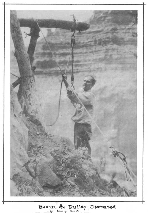
At this time, Colonel Birdseye, then Chief Topographic Engineer, requested my brother and me to give the falls an Indian name. My brother chose Cheyava, meaning in Hopi, intermittent river, which at the time we thought applicable. Upon later investigation we found that our supposition that the water dried up entirely during part of the year was probably incorrect. In the middle of September 1930 when my brother and I thought the falls to be entirely dry, we decided to explore the cave. To our disadvantage on the one hand and delight on the other, we were surprised to find considerable water, undiscernible at a distance at that time of the year, running through crevices and brush at the mouth of the cave. This led us to believe that there is some perennial water at the falls. Reaching the cave at the head of Cheyava Falls was no minor undertaking, although through our telescope it appeared to us that the 2000 foot descent to the top of the Blue Lime Wall could be reached without much rope-work. A final 200 foot sheer drop over this wall to a projection underneath the cave was anticipated. My brother drove around to the North Rim equipped with ropes, pulleys, beds, etc., to search for the nearest approach by road to a place from which we could make the descent to Cheyava Falls. When this was located, he phoned that all was in readiness. Then to curtail the absence from my daily lectures on the South Rim and thinking the job might be done in about one and a half days, I flew across. My brother met me at the air field and we slept in the pines in order to make a fairly early start in the morning. At the rim of Grand Canyon where we descended, a huge cut or slide had been formed through the entire Kaibab formation and almost to the bottom of the usually perpendicular Coconino Sandstone cliff. Through the telescope the cut had appeared to be complete, but arriving near the bottom of it with our load of ropes, cameras, food, and other equipment, we were stopped by an eighty foot precipitous drop. Our loads were lowered to the bottom of it with a rope. Then we found a route for ourselves provided by several fir trees which were growing twenty to twenty-five feet from the base of the cliff and which extended up to the ledge on top. The upper part of one of these trees was snared. The other end of the rope was then fastened around a huge rock and over the rope and down the tree we climbed, over-coming our first difficulty. At the base of the Coconino cliff food was left for our return. No hats or coats were taken. Our sacks, canteens and huge coils of dangling rope gave us enough trouble in the thick brush. About 400 feet below, another ledge - this one with a drop of about forty feet - was passed with the aid of a wire, which we left there. Then about halfway down the red Supai wall, a huge fir tree which had been stripped of its limbs by rocks, was slid down three hundred feet and over another 40 foot drop. The small end of the tree flopped down first, making the pole difficult to "coon". One hundred and twenty-five feet of rope were left at a still lower point over a series of sheer ledges. From there on, having nothing but a rough slope to contend with, we were able to climb down to the top of the blue lime without the aid of ropes. The amount of rope distributed over the ledges for our return left us but 400 feet of one half inch line for our block and tackle - just half the amount needed. Darkness was now upon us so we covered ourselves as best we could with knapsacks and whiled away the hours until daylight. We were by this time without food and water, so leaving our cameras and other equipment, we climbed out to obtain more rope and provisions. On the North Rim about 200 feet of three eighth inch rope was all we could secure, but we decided to make the final 200-foot descent with this addition. The following noon we "topped-off" again, taking what we thought to be sufficient food and water and leaving another cache at the base of the Coconino. It was too late to accomplish much that evening so another night was spent just above the cave. A miserable night it was - no shelter. My brother and I worked all the following morning constructing a boom over the ledge to attach our pulleys to. The brush hampered our work in stringing out the 600 feet of rope, and it was nearly five o'clock in the afternoon when we were ready for the final descent. A heavy storm was brewing, but as we were out of food and water, Ellsworth decided to take the canteen and make the drop anyway to the sparkling water, 200 feet below us.
Sitting in a loop, down my brother started. As I handled the slack end of the rope, I could peer a thousand feet below into the Clear Creek Canyon. Ellsworth was just half way down to the cave when we were caught in one of the most terrific rain and hail storms I have ever experienced. The lightning struck close by many times. So strong was the wind, I had fear of being blown from the cliff.* I withdrew from the edge, tying the rope to a small Pinyon pine, leaving my brother dangling in the air, and since the cliff receded below, he was prevented from steadying himself against the wall. This permitted the wind to whirl him round and round until the three wet ropes became one.
When the storm abated some, I dropped a pole to my brother on a thin line, and he used it to gradually unwind himself. It was a long task but finally the rope slackened. Then inch by inch I let him down. The cave exploration was necessarily cut very short since we had no lights, also because 200 feet of loose rope had to be untangled from small trees and brush on the ledge below and the hour was growing late. My brother filled the canteen, then I began pulling his 165 pounds of weight up with the three-way rope system which necessitated much more effort than the usual four-way block and tackle. Ellsworth dropped his pole and again the rope spun, but by dark I had him up. I was exhausted. The strain of pulling my brother up had been such that I developed an uncomfortable rupture and this caused no little annoyance in the climb back over the ropes. Ascending in total darkness, we reached the cache at the base of the Coconino where we remained even though it rained the whole night through. At the break of day, my brother and I climbed the tree and "cooned" the rope to the base of the big talus slide. Without further delay we "topped-out" reaching our car about 10 a.m. My condition prevented further immediate attempts at the cave, and I could not then either walk or ride across the canyon by trail, so my return to the South Rim was made by airplane. The trip had lasted six days instead of the alloted one and a half. At a later time, with the aid of a helper to handle the ropes at the pulley, my brother made two more attempts to reach the cave. A weighted wire was dropped beside the ropes, preventing then from spinning. But not until the third attempt, when he took a twenty-foot ladder to get over rocks in the cave, did he make any real ingress. The cave as described by my brother is approximately 60 feet high at the entrance, with the lower opening blocked by huge rocks which have fallen from the ceiling. Inside, the ceiling extends upward in the shape of a dome, 100 to 150 feet in height. The width is about 100 feet and a lake extends 600 feet back. This is divided by a huge rock or ledge necessitating the use of a 20 foot ladder. There are no stalactites of importance but many lime crystals and incrustations are in evidence. Except across 75 feet at the end of the room my brother found no wading necessary. At that point the ceiling tapered down to within two feet of the water. A cataract could be heard beyond, but he made no attempt to duck under the ceiling and examine further. A fine trail is now being constructed from Bright Angel Creek to the base of the Clear Creek waterfalls, but there is still opportunity for the adventurous person to further explore the cave. Our boom yet hangs over the cliff, patiently waiting for the next explorer. | ||||||
| <<< Previous | > Cover < | Next >>> |
nhb-2e.htm
14-Oct-2011