|
|
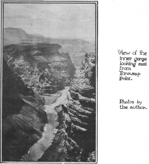
By Ben H. Thompson, Wild Life Division, TOROWEAP. the fertile valley known to the Indians as Tuweap, has been dedicated to the good of the American People. By presidential proclamation of December 22, 1932, an area of approximately four hundred square miles immediately west of Grand Canyon National Park was formally designated as Grand Canyon National Monument. Roughly, the Monument is bounded by the crest of the volcanic Trumbull Mountains on the west, by the gorge of the Colorado River and by the Hualpai Indian Reservation on the south, by a portion of Grand Canyon National Park and a segment of Kanab Canyon on the east, and on the north by an arbitrary line across the sage and juniper plateau from Kanab Canyon to Mount Trumbull. Down through the western portion of the Monument, Toroweap Valley runs its course to the gorge. The lower portion of the valley is over three miles wide and nearly level. At the southern end of the valley, on the very brink of the gorge sits the ash cone known as Vulcan's Throne. From the top of Vulcan's Throne one views the scenes made famous by the drawings of Holmes (Dutton1 1882, Atlas sheets). From east to west flows the Colorado River, nearly three-quarters of a mile below in the narrow gorge. Toroweap Valley lies north and south with Vulcan's Throne at the crux. On the east of the valley the cliffs of Kaibab Limestone and Coconino sandstone rise about eighteen hundred feet to the level of the Kanab Plateau. The eastern cliffs are noticeably higher than the western. To the west of Toroweap, the lava body of the Trumbull Mountains lies on top of the limestone, and lava flows spill over the cliffs and down into the valley. 1. Dutton, D. E., 1882. Tertiary History of the Grand Canyon District, with Atlas. Monogr. II, U. S. Geol. Survey. When one comes into the region it is natural to wonder about the particular story of creation applicable here. Davis2 has given an account which adds greatly to the interest of one visiting the valley. 2. Davis, M. W. 1930. An Excursion to the Plateau Province of Utah and Arizona. Bull. Mus. Comp. Zool., XLII, Geological Series, Vol. VI, No. 1. At some time during the upheaval of the plateau through which the Grand Canyon now cuts, the Toroweap-Sevier Fault occurred. The line of the fault is particularly noticeable where the Colorado River cuts across it. The block to the east rose and the block to the west sank, relatively, so that there was a vertical slippage of some six hundred or seven hundred feet along the fault surfaces. Strata of rock were weakened, which allowed the forces of erosion to carve Toroweap Valley. This all took place prior to the cutting of the inner gorge by the Colorado River. During the cutting of the gorge, Toroweap Valley would probably have been cut correspondingly deep, except that lava flows (occurring long after the fault and some time during the cutting of the gorge) spread across the lower end of the valley and held the valley floor at its present level. Meanwhile, the Colorado has cut the inner gorge three thousand feet below the floor of Toroweap, and the cliffs bounding the valley have slowly receded. In effect then, Torowweap appears as a valley hanging three thousand feet above the bottom of the inner gorge. Toroweap Point, whence the most spectacular views of the Canyon are obtained, is at the southeast corner of the valley where the chasm swings around a corner of the sandrocks, or the esplanade. Wandering around through the little ravines of the esplanade, one suddenly comes to the unsuspected brink of the gorge. It is impossible to take in the height or depth of the walls at a glance. By the time one's eyes have followed the great wall to the bottom it is necessary to look up again to retrieve the lost impression. It is to this point that the National Park Service plans to build a road, for there are merely sandy desert trails leading into the valley at present.
On May 2, 1933, Superintendent Tillotson and Chief Ranger Brooks of Grand Canyon National Park, and the writer, representing the Wild Life Division of the National Park Service, made a reconnaissance trip into the Monument. Our trip lay west from Fredonia, Arizona, to eight miles west of Pipe Springs National Monument, thence south about thirty-eight miles over the sheep and cattle grazed Public Domain into Tuweap, the little settlement in the heart of Toroweap Valley. This part of the Public Domain is badly over-grazed, erosion is severe, and loco weed and other undesirable indicators are present. A little snow squall ushered us into the valley. A few homesteads dot this area. Cattle, horses, grains, fruits and vegetables are produced on these ranches, The pioneers, for they are truly that in the laudable sense of the word, live literally from the soil. At the home of W. A. Kent, with whom we stayed, we were treated with genuine pioneer hospitality to the best table that the ranch could provide, which was ample and savory; to horses and guidance for the trips through the Monument, and to bronco busting for diversion. The next three days were spent in riding the range. The archaeology of the region presents intriguing features. Numerous Indian mounds are scattered over the valley floor and among the cliffs, and pottery sherds are commonly seen. Various stories were recounted of the finding of perfect pottery specimens among the ledges of the walls. Old scars of prehistoric irrigation ditches are still perceptible. Kent told us that the Indians have legends of the days when they cultivated this fertile valley. Plant and animal life ranges from the Lower Sonoran type down in the gorge, to the Transition, or yellow pine type, on Mount Trumbull. The greater part of the Monument east of Toroweap Valley is the gently rolling Kanab Plateau, covered with a low forest of juniper and pinyon, here and there broken by open sagebrush hollows. Sheep have ranged over the plateau in winter, but have been removed each summer because there is no water after the snow melts. A few deer are still found down along the breaks near the edge of the Canyon. The sandrocks are also covered with juniper, pinyon and sage, but browse plants are more abundant than on the plateau. Cliff rose, snowberry, Brigham tea, yucca, century plant, rabbitbrush, mountain mahogany, gooseberry, ceanothis, and many others make up the character of the cover. Numerous wild flowers, especially the phloxes, paint brush, pentstemons and four o'clocks lend color to the rocks. The floor of Toroweap Valley is largely covered with native bunch grasses, sage, saltbush, greasewood, rabbitbrush and cactus. As one ascends Mount Trumbull the pinyon-juniper types disappear, and manzanita, service-berry, silk-tassel, and Gambel oak predominate, with the ever present sage. Finally, the Western Yellow Pine forest is reached, and the desert is left behind. The view from the top of Mount Trumbull is one of grandeur. It is the duty of the National Park Service to preserve in unimpaired condition the areas chosen as National Parks and Monuments. This is not difficult insofar as the large physical features are concerned, but with the plant and animal life the situation is different. For a number of years prior to 1900 the area now in the Monument was utilized as cattle range, and in more recent years it has been utilized by both cattle and sheep. Consequently, the range has been somewhat depleted and the character of the vegetation correspondingly modified. A gradual restoration of these valuable and interesting resources will be necessary before the Monument can fulfill all the purposes for which it is dedicated. A look into faunal conditions of the past, those of the present and the faunal prospect for the future may give some idea of the type of work the National Park Service is undertaking to preserve for the American people the native values of wilderness life. In years past, antelope roamed over the Kanab Plateau, between the Vermilion Cliffs and the Colorado River. Indians recount their hunting expeditions into the region, and later white settlers recall seeing antelope as recently as a few years ago. It is possible and even probable that some of these antelope at least wintered down in Toroweap Valley, and certainly they inhabited the plateau above the valley. Particularly is the greasewood-sagebrush-grassland type of cover on the valley floor suitable as antelope forage. Would it not then be desirable to re-introduce this native animal, the only one of its kind in the world, for the enjoyment and benefit of people who will drive down the valley to Toroweap Point? While it is perhaps true that the animals will not have the unlimited range which they had in former times, there is considerable range available in the Monument and conditions appear ideal for antelope.
Mountain sheep are native to the Grand Canyon and are found all through it. They are scarce, however, and seldom seen. Ordinarily, they retreat before the advance of civilization, but in and around Toroweap the native sheep seem to have became accustomed to the presence of man. Kent reported seeing two of these animals along the eastern cliff of the valley the week prier to our visit, and he has seen mountain sheep commonly along the esplanade between the cliffs and the inner gorge. With the complete protection given these animals by the Park Service, they should be able to maintain themselves, and become one of the quests of the visitor. Mule deer are also indigenous to the area. They, like the antelope and mountain sheep, have suffered from the presence and competition of domestic grazing in the region. The esplanade presents ideal winter range for deer. The Kanab Plateau, near the breaks of the Canyon, and the middle and upper reaches of the Trumbull Mountains carry ample and nutritious summer forage. Given protection from hunting, a restoration of the range and their former normal habitat, the deer should increase and resume their native haunts. Coyotes, gray foxes, cougars, bobcats, cacomistles, badgers and the little Canyon spotted skunks are all present and native to the Monument. However, each winter these furbearers have been trapped and their numbers decimated. Cougars have been hunted in the Trumbulls and from the sheep and cattle ranges until nearly extirpated. Coyotes are perhaps the most numerous of the carnivores just listed, but they are not as abundant as formerly. Although coyote tracks were seen a few times as we rode over the range, their nightly calls were not heard. Interesting rodents are in evidence everywhere. The little cinnamon ground squirrels may be seen from the sandrocks to the pine forest of Mount Trumbull. Jack rabbits and cottontails are found all through the sagebrush areas. Rabbits were more numerous three or four years ago, according to local report. The cause of their depletion is not known, but it is thought that they are on the increase at present. The rodents of the region are too numerous to list here. It is noticeable that the prairie dogs, so common just south of the Canyon, are absent from Toroweap. A yellow-haired porcupine was seen at the base of the mountains and a few porcupine scars were found. Bird life of the Monument is abundant and varied. Above the crest of Mount Trumbull golden eagles, vultures and sparrow hawks were seen. In the pine forest, Audobon's warblers, purple finches, gnatcatchers, pinyon jays and white-breasted woodpeckers were seen and heard. The Natalie's sapsucker flew through the trees, a bright splash of color. Down in the sand-rocks, white-throated swifts and violet-green swallows flew about the ledges of the gorge. Pinyon jays, gnatcatchers, horned larks, rock wrens, and many others were heard and seen. Mourning doves were numerous throughout the region, and Gambel's quail are reported seen at times. Of the wild life, birds have probably suffered the least from human utilization of the region. With intelligent and careful management the native fauna and flora of the Monument should be restored. The process of restoration is not rapid or spectacular, but under consistent policies applied over many years, the rare and fascinating native forms of life will be restored and preserved. The most interesting features of the Monument have barely been touched in this account. It is believed, however, that it indicates something of what may be found when one visits Grand Canyon National Monument. | ||||||
| <<< Previous | > Cover < | Next >>> |
vol8-4c.htm
14-Oct-2011