|
|
By Edwin D. McKee, Park Naturalist.
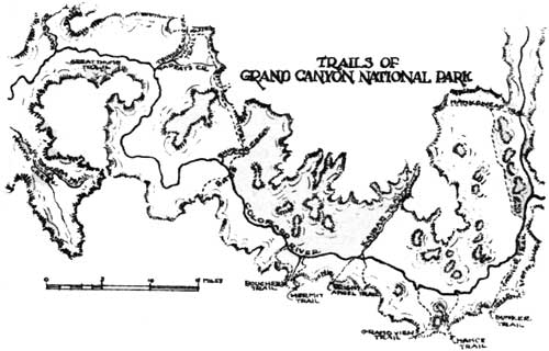
MUCH of the romance of the Grand Canyon is intimately as with the development and history of its trails. Although only two of these are commonly used today, no less than eleven are found zig-zagging down from the South Rim into the Canyon depths, and four others occur on the north side, within the boundaries of the National Park. This number is rather remarkable when one considers the general structure and topography of the Canyon walls which form an absolute barrier to man in most places. Throughout the Grand Canyon the Coconino sandstone cliff, averaging 300 feet in height, and the great Redwall, forming a sheer drop of over 500 feet, are two of many obstacles to the descent. Undoubtedly the best known of Grand Canyon trails is the Bright Angel, which starts at Grand Canyon Village, and, descending the great valley caused by a fault of the same name, passes through Indian Gardens, and thence on to the Colorado River below. This trail is not lacking in history. During part of the past century and perhaps for a long time before, the natural route which the trail now follows was used by Havasupai Indians who lived and farmed at Indian Gardens. In 1890-91 a group of hardy pioneers, including Ralph Cameron and the late Pete Berry, did the first real work on constructing the Bright Angel trail - then known as the Cameron trail. Their labors were largely due to the inspiration given by mining claims in the neighborhood of Indian Gardens, but their rewards were derived from toll collected at the head of the trail rather than from valuable ores at its base. In the course of years, when the mining claims along it were shown to be invalid, the old Bright Angel Trail with its famed Devil's Cork-screw and its Jacob's Ladder passed into the hands of the county. Toll continued to be collected however, until 1928, when, after a complicated deal, the trail became the property of the National Park Service. In the winter of 1930 it was largely remade in order to lessen the grade and in 1932 it was oiled. At present it is one of the two trails in common use, and is considered a "boulevard" by old timers. Today the Kaibab trail, the construction of which was completed by the National Park Service in 1928, is the only practical route for crossing from rim to rim of Grand Canyon. Large parts of it, particularly on the south side of the Colorado River, were built by the sheer power of blasting, but the section along Bright Angel Creek fellows a natural passageway which was used by Matthes1 with a pack train as early as 1902. To be sure, the creek had to be forded some 94 times in former days, as compared to seven today - nevertheless, this part of the route was a natural one for both man and beast as is testified by the proximity of several cliff dwellings built by early Pueblans, and by the mescal pits of later Indians. In former times, two other routes - one to the east and the other to the west - were commonly used in traversing Grand Canyon. The eastern route began in the little basin just west of Cedar Mountain and followed the promontory in front of Desert View Point down to the river. According to Mr. George McCormick2 of Flagstaff, whose name has long been associated with the eastern part of the Grand Canyon, this - the Tanner trail - was used by the Navaho Indians under Old Begonia when they were trying to escape the American soldiers under Col. Kit Carson in the 'sixties. "In about 1889 Tanner, Lewis Bedlias and Fred Bunker built the trail (a branch from the original) from the Blue Lime up to the top, close to Desert View, and it was called the Bunker Trail." Mr. McCormick further states that the present upper part of the trail was built by himself at a later date, and, as is commonly known it has been improved by him from time to time as assessment work on his copper claims below. It is still passable without extreme danger or difficulty for a pack train. The usual route followed by cross-canyon travelers after descending the Tanner or Bunker trails was along the east side of the Colorado River as far as the McCormick copper claims opposite Chuar Creek, thence across the river at a fairly wide but calm stretch, up Lava Canyon to the natural break formed by the Butte fault, and then along the west side of the Buttes to Nankoweap Basin. The writer hiked over much of this route while doing geological work in the fall of 1932, and found the river crossing and the trail fairly easy to travel. During the preceding spring, on the other band, the river had been found so high that it could not have been crossed at the same place without considerable danger. Although today this remote section is seldom frequented by man, there are many evidences of his former presence. Rock piles and cairns are to be seen in numerous places, and even an ancient distillery was found near the upper part of Chuar Creek.3 According to many stories that still survive, this section of Grand Canyon was a favorite hide-out for renegades, poachers and horse thieves. It seems that stealing horses was a particularly profitable business, for thieves could take the animals from the Mormons of Southern Utah, drive them through the Canyon into the Flagstaff area to sell, then steal horses in that area and take them up into Utah, thus making a profit each way.
The North Rim and House Rock Valley could be reached from eastern Grand Canyon ever the Nankoweap trail which was built just prior to 1880 under the direction of Major J. W. Powell to be used by Dr. Walcott in making geological studies in that region. Its upper end is in the "Saddle" near Point Imperial, and although much washed and worn by now, was still sufficiently good to permit a party4 to travel it by mule as recently as 1931.*
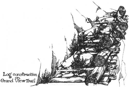
West of the Bunker-Tanner trail is the Hance trail, or what still remains of it, leading down Red (Congress) Canyon to the river. This trail is undoubtedly in the worst shape of any in Grand Canyon with the possible exception of the Boucher. It is today impossible to take mules over the Hance trail without repairing it in many places, and it is even very difficult to negotiate on foot. According to Tillotson5 it is a reworked Indian trail, and was traveled in February 1882 by a Mrs. Edward Ayres who was reputed to be the first white woman to go to the bottom of the Grand Canyon. Later it was used to some extent for packing asbestos out of the Canyon from mines located across the river. The writer recently found an old wooden sign still in place, nailed to a large tree at the trail head, with much weathered but faintly discernible words on it - "Toll on Trail, Foot Man $1.00, Saddle Animal $2.00." This sign now reposes in the Park historical collection. Hance Canyon has no regular trail descending it, although game paths wind over the talus near the top. In October, 1929 the writer was able, with extreme difficulty, to climb down it to the Tonto, and thence part way into the Inner Gorge, where passage was finally blocked by a cliff. The trail below Grandview Point was formerly known as the Berry Trail, after the late Mr. P. D. Berry, who built it. Within recent years, however, it has commonly been called the Grandview trail. According to information obtained from Mr. Berry just before his death last year, work on this trail was commenced on July 20, 1892, and finished the following year. The primary purpose in building it was to enable the working of copper mines near its lower end. The cost of building and upkeep during the time it was used was estimated by Mr. Berry to have been about $12,000.00, however, during much of this time eight or ten mules with a packer were run over it each day. About 200 pounds of ore were brought from the mine to the head of the trail on each mule, and the train could make one and a half trips per day. Work on the mines was continued until 1907 when a decline in the price of copper made it necessary to give this up. As late as 1916, however, Mr. Berry took down a party. The writer has been over the Grandview trail several times during the past few years and found it still in fair shape for hiking, although covered in places by slides. 1. "Breaking a Trail Through Bright Angel Canyon", G.C. Nature Notes, Vol. 2, No. 6, 1927. 2. George McCormick, personal communication, June 6, 1932. 3. G. E. Sturdevant, G.C. Nature Notes, Vol. 3, No. 6, 1928. 4. C. E. Resser, "Report on Nankoweap Trip", G.C. Nature Notes, Vol. 4, No. 8, 1930. 5. M. R. Tillotson and Frank J. Taylor, "Grand Canyon Country" p. 65, 1929.
| ||||||
| <<< Previous | > Cover < | Next >>> |
vol8-5c.htm
14-Oct-2011