|
|
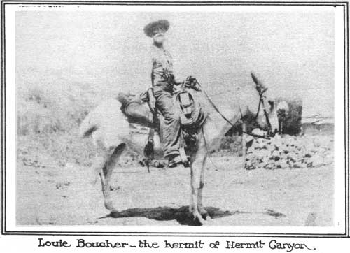
THE name "Hermit" which has been given to numerous objects located in the area just west of Grand Canyon Village, was originally suggested by the presence in that region of a pioneer named Louis Boucher.
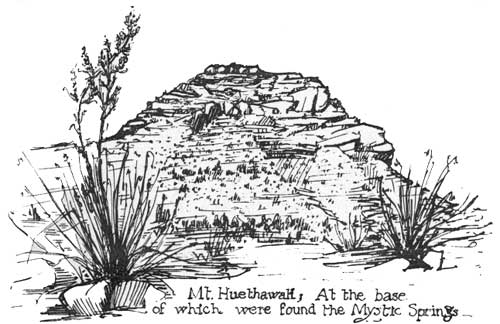
What is probably the most seldom traveled and least known Canyon trail today was built by old Louie sometime between 1889 and 1893. The upper part leads to the charming locality known as Dripping Springs, entering Hermit Basin from the southwest. A continuation of it along the upper west walls of Hermit Canyon, descends into Boucher Canyon farther down, and there Louie established what must have been a rather comfortable, if isolated, camp. The Boucher trail has been in disuse for so many years that it appeared impossible to obtain any authentic data concerning it until last fall when a visitor to Grand Canyon disclosed his identity as one of the co-workers of old Louie Boucher. To this visitor, a Mr. Edward W. Murphy of New York City, we are indebted for the picture of Louie and also for some other pictures showing the camp at Dripping Springs. Mr. Murphy stated that he had spent several months here about 1890, and with a cow puncher named Johnny Stevens and a man from New York whose name he could not recall, but who "owned a box camera", had helped to build the trail to Dripping Springs. At the time he had no idea what was the purpose of this construction project, except that the men wished to reach the fine camping site at the springs. Old Louis, he said, was a very reticent man and a typical prospector, possessing geology pick, pen and tools for trail making. Louie also owned several burros, a white mule with a bell, and a tent. In 1911-12 a second trail was constructed down into Hermit Basin and Hermit Canyon. This trail was built by the Santa Fe Railroad, and was for tourist use. It skirted the east side of the Canyon and descended it all the way to the river. In 1919 it was turned over to the National Park Service which maintained it for over twelve years, when it was finally abandoned. In the extreme western part of Grand Canyon are three other trails of considerable interest. One of these, without name, zig-zags down from Great Thumb Point to the Red Esplanads bench below. It is very rugged, used only by the Havasupai Indians and so far as can be determined was developed by them for hunting and other purposes. A second Indian trail is the Topocoba which starts near a spring having the same name, and leads to the Indian village of Supai down in Havasu Canyon. This trail approximates and in places follows the scar of an attempted wagon road, the construction of which was unsuccessfully carried on by the Grand Canyon Gold and Platinum Company, an Eastern concern organized in about 1902. Prior to that time the same general route had been used for over fifteen years in connection with the mining of lead and silver ores, and probably for many generations before that by the Havasupai Indians. The old Bass Trail, descending from a place near Havasupai Point down Bass Canyon, thence up Shinumo and White Creeks to the North Rim at Powell Saddle, was largely developed by the famous pioneer W. W. Bass, recently deceased. The section leading from the South Rim to the Red Esplanade shelf below probably started as an Indian trail, for it was used by the Havasupais to Mystic Springs at the base of Mt. Huethawah many years ago. Sometime in the '90s that spring is reported to have disappeared following an earthquake but the route to it was followed by Bass in making his trail to the river in 1895.1 Information obtained from Mr. Bass before his death indicates that some of the northern part of this trans-canyon route was first developed by a prospector from the North Rim area named White, the man after whom White Creek received its name.
Bass recognized mining claims as a cause for this development but also harbored suspicion that the route was commonly used by a band of horse thieves in reaching their rendezvous. In later years Bass himself developed both copper and asbestos mines in the area, and used his trail to the South Rim in packing out these minerals. He also built up a good tourist trade, and in 1900 developed a fine fruit orchard and garden plot near the mouth of Shinumo Creek. This place was known as Shinumo Gardens, and was the Phantom Ranch of early days. The north section of the Bass Trail is now commonly called the Shinumo Trail. One other Grand Canyon trail is found descending from the North Rim in the western area. This trail goes down Tapeats Canyon and is commonly referred to by the romantic name of Thunder River Trail. Concerning its early history and origin the writer has been able to obtain but little information. According to R. E. Laws of Kanab, Utah, the Piute Indians used the upper part down to the Supai sandstone many years ago and left evidence of their occupancy in some of the large caves in that vicinity. In later years this part of the trail was worked and used by the Forest Service and also by cattlemen who wintered their stock above Thunder River. In 1925-6 Ranger Laws and others working for the Forest Service, constructed the lower portion of the trail, down through the Redwall to a spring below. Since then no work has been done and the trail is in very poor shape at present. It is realized that this sketch of the history and development of Grand Canyon trails is far from being complete. It represents, nevertheless, the results of considerable work in assembling historical data, and is presented in an attempt to permanently record interesting facts which have not before been placed in print and which are in danger of soon becoming lost. If any of the readers are able to contribute further information on any of the Grand Canyon trails, they are urged to do so. The Natural History Association will welcome any assistance in gathering together this material.
| ||||||
| <<< Previous | > Cover < |
vol8-6f.htm
14-Oct-2011