|
|
IN 1858 Dr. J. S. Newberry, geologist on Lt. Ives' exploring expedition, recognized in the valley of the Little Colorado River where he crossed it about 40 miles below the present town of Winslow, a series of rocks which was definitely above and of later age than the highest which he had seen exposed in the walls of Grand Canyon. These rocks, 500 feet thick, were for the most part red sandstones and shale, and he referred to then as the "Saliferous series" or "red sandstone series". During the past sixty years many geologists working in the Grand Canyon region have noted the presence of Newberry's "Saliferous series" in various localities and have contributed to our knowledge of the history and extent of these rocks. Among a large accumulation of data, two things appear to have especial significance. First, since the remnants of these strata are found north, south, east and west of Grand Canyon and since they are known to have been formed during the Triassic period (first part of the "Age of Dinosaurs"), it is clearly evident that rocks of this age once covered the entire Grand Canyon area. Second, these remnants furnished evidence that a long period of erosion and wearing away of the region occurred just prior to the beginning of actual Grand Canyon cutting. That rocks of the "Age of Dinosaurs" once covered the Grand Canyon Area, there appears to be very little doubt, but concerning the original thickness of this former covering mantle there is much room for speculation. Since to the east and north of Grand Canyon one encounters steps representing successively later and later periods of history, physiographers in general have been inclined to conclude that the total thickness of these formations as found in neighboring areas, about 6,000 feet of rock, once covered the present topmost layer of Grand Canyon. But this is open to question. South and west of Grand Canyon remnants of the "Age of Dinosaurs" contain only the "Saliferous series" of Newberry, now known as the Moencopie formation, and parts of the overlying Shinarump-Chinle formation. These then, with a combined thickness of probably not over 1,500 feet, are the only layers of rock which we can be sure covered the entire area in former times. It is probable, nevertheless, judging from the present proximity of the Vermilion cliffs, that the rocks of which they are composed (Jurassic age) once also covered Grand Canyon area, though obviously with much less thickness than they have in southern Utah since they become thinner toward the south and west. Overlying Cretaceous rocks may or may not have originally extended as far to the southwest as Grand Canyon. On the other hand, it seems almost certain that the still higher rocks of Tertiary age as found at Bryce Canyon, Utah, and Ganado, Arizona, did not, since they are far removed at present and they represent fresh water deposits which probably never has a very great areal extent. In brief, then, we can only say with assurance that the mantle of rock which formerly covered the Grand Canyon area was over 1,500 feet in thickness but probably considerably less than 6,000 feet.
South of Grand Canyon isolated remnants of the Moencopie formation are found in about nine scattered localities, the farthest southwest of which is in Sycamore Canyon. Both there and in Anderson mesa to the east the exposures are quite extensive laterally and in both oases are protected by lava caps. Since these and the other Moencopie remnants have considerable bearing on the history of the region, their extent and nature is here summarized: PRINCIPAL OUTCROPS OF TRIASSIC ROCKS SOUTH OF GRAND CANYON.
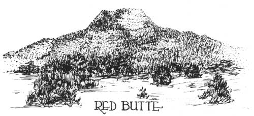
Near Grand Canyon, outliers of rocks of the "Age of Dinosaurs" such as Red Butte to the south and Cedar Mesa to the east have long been recognized for what they are. Remnants of such rocks occurring actually on the rim of Grand Canyon, however, have not heretofore been recorded but since the writer has recently discovered their presence there, he takes this opportunity of making known the details. Just west of the Hance trail and east of the steep hill formed by the Grandview monocline is one such exposure extending along the rim for perhaps half a mile. It includes the basal conglomerate member, 8 to 16 feet thick, and about the same thickness of red, thin-bedded, sandy shales above. These shales are also to be seen along the Bright Angel fault not far back from the canyon rim on the road to Havasu Canyon (about two miles S.W. of Rowe's Well) but there the underlying conglomerate and the Kaibab formation are not exposed. One importance of the discovery of the Moencopie formation on the rim of Grand Canyon is that it clearly shows that only a very small part of the Kaibab formation has been removed over much of this area by recent erosion. Beneath the Moencopie is found only a thin exposure of the so-called A-member or Harrisburg gypsiferous member of the Kaibab. It consists in this locality of two ledges of limestone each containing abundant casts of Permian pelecypods and gastropods, separated from each other by an irregularly-bedded crumbly, red sandstone. The red sandstone layer is seen at Yaki Point and on the Buggeln hill along the Desert View road where it has been mistaken for Moencopie sandstone because of its color. However, there is no need for confusion if one compares lithologic characters. The underlying limestone is the rock that covers a major portion of the plateau surface. Along the rim of Grand Canyon west of Hance trail the contact between the Moencopie and Kaibab formations, representing a break between two great chapters of geological history, is plainly visible. The subangular pebbles at the base of the former, ranging in diameter up to 2-1/2 inches, completely cover the flat limestone surface of the latter and in places fill small depressions and channels out into it. These pebbles are all of the most durable types of rock - jasper, chert, quartz, etc. - varying greatly in color but probably derived mostly from the Kaibab formation and transported only a short distance. A similar bed of conglomerate has been noted at the base of the Moencopie where the writer has examined it north of Cedar Mesa, along the Little Colorado Canyon, near Cedar Ridge Trading Post, in Sycamore Canyon and in the valley of the Little Colorado. Robinson (1) records a similar bed, 5 feet thick, at Anderson Mesa to the south, so it probably represents a fairly constant unit at the base of the Moencopie formation. 1. Robinson, H. H., The San Franciscan Volcanic Field, Arizona, U.S. Geol. Survey Prof. Paper 76, p. 27, 1931. 2. Gilbert, G. K., U.S. Geog. Surveys W. 100th Mer., Vol. 3, 1875. 3. Newberry, J. S., Report upon the Colorado River of the West, explored 1857-58 by Lt. J. C. Ives, pt. 3, 1861. 4. Ward, L. F. Geology of the Little Colorado Valley, Am. Jour. Sci., 4th ser., vol. 12, 1901.
| ||||||||||||||||||||||||||||||||||||||||||||||||||
| <<< Previous | > Cover < | Next >>> |
vol9-5d.htm
14-Oct-2011