|
HAWAI'I VOLCANOES & HALEAKALA Volcanoes of the National Parks of Hawaii |

|
THE HAWAIIAN VOLCANO OBSERVATORY
The Hawaiian Volcano Observatory was established in 1912 by Dr. T. A. Jaggar, of the staff of the Massachusetts Institute of Technology, and for the first 7 years of its existence it operated on funds provided by the Institute from its Whitney Fund for research in geophysics and by the Hawaiian Volcano Research Association. The latter was a group, largely residents of Hawaii and principally business men, who were actively interested in the study of volcanoes. In 1919 the administration of the Volcano Observatory was taken over by the United States Weather Bureau, which was then charged by Congress with the responsibility for earthquake investigations in the United States. In 1924 the observatory passed to the U. S. Geological Survey, in 1935 to the National Park Service, and in 1948 back to the Geological Survey. It is currently a part of the Geological Survey's volcano investigation program.
The original location of the Volcano Observatory was the site now occupied by the Volcano House. When the present Volcano House was built in 1941, the observatory was transferred to what is now the Park Museum and Administration Building, and in 1948 to a building on the western rim of Kilauea caldera at Uwekahuna. Dr. Jaggar continued as director of the observatory until his retirement in 1940.
Since 1912, Kilauea and Mauna Loa volcanoes have been under constant close observation by members of the observatory staff. The studies by the Volcano Observatory have two general purposes, the directly practical purpose and the long range scientific studies. The two are difficult to separate, because a phase that belongs to objective science today may become of great practical use and importance within a few years. In general, the scientific work of the observatory program is directed toward an understanding of the subsurface structure of the volcanoes, the nature and properties of the magma, how the volcanoes behave, and why. The directly practical aspects include prediction of eruptions and of the course of lava flows once the eruption has started, and issuing of warnings of danger from lava flows.
An example of one phase of the observatory program that is of objective scientific importance at present but may become of great practical use in the future is the investigation of the volcanic gases and their relation to the magma and effects on surrounding rocks. A large proportion of the natural deposits of metallic ores were formed either directly or indirectly by emanations (gaseous or liquid) given off by intrusive bodies of magma. The known ore bodies are being mined out, and the finding of new deposits is becoming ever more difficult. The location of new deposits is becoming the province of the trained scientist rather than that of the old-fashioned prospector, and demands an ever better understanding of how they were formed. The effects of the magmatic emanations are being studied in old ore deposits all over the world and the composition and properties of the emanations deduced from indirect evidence, but the only places the emanations themselves can be studied directly is at active volcanoes and hot springs.
The work of the Volcano Observatory includes visual observations of the volcanic eruptions and keeping of a complete diary of the activity, collection of gas and lava samples, determination of temperatures of liquid and solidifying lava and of the gases liberated in fumaroles, the operation of tilt-meters, and a net of seismograph stations.

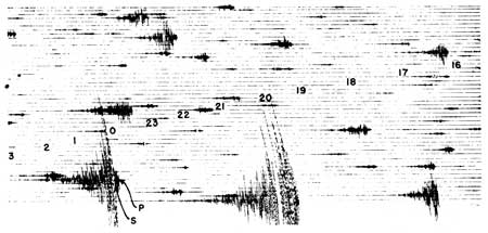
FIGURE 9. Portion of a record from the vertical seismograph on
December 9 and 10, 1950, showing part of the earthquake swarm during
relaxation of pressure beneath Kilauea Volcano in early December. During
the 3 hours of total time represented in the figure approximately 130
distinct earthquakes, most of them small, can be counted on the original
record. The numbers mark the hours from 1600 on December 9 to 0300 on
December 10, Hawaiian time. Records of two large earthquakes appear near
the bottom. On the one to the left P marks the arrival of the
Preliminary waves and S the arrival of the Secondary and surface waves,
which arrive almost simultaneously for earthquakes of nearby
origin.
A seismograph is a device to record earthquake motion. The essential part of most seismographs is a freely suspended weight which, because of its inertia, during earthquakes tends to stand still while the earth moves under it. The effect is nearly the same as it would be if the earth were still and the weight vibrating. This apparent movement of the weight is recorded in various ways — by direct mechanical means, by directing a beam of light onto photographic paper, or electrically. The weights are generally arranged so that they vibrate in north-south, east-west, and vertical directions. This movement is magnified and recorded on paper on a revolving drum, or on photographic film or magnetic tape. So long as the earth is quiet the line drawn on the paper is straight, but when an earthquake occurs the weight moves back and forth in relation to the ground and the line drawn on the record is wiggly (Figure 9).
An earthquake consists of several types of vibrations (Figure 9) which travel through the rock at different known speeds. By identifying on the record the times of arrival of the different types of vibration, the distance from the station at which the earthquake originated can be calculated. Then by using the distances of origin from several stations, the epicenter and depth of origin of the earthquake can be determined. Any marked increase in the number of earthquakes indicates a restlessness of the volcano in which the earthquakes originate, and the location of the earthquakes origin indicates what part of the volcano is involved. Commonly an eruption is preceded by a series of earthquakes.