|
MOUNT RAINIER NATURE NOTES
|
| Vol. XI |
October - 1933 |
No. 8 |

|
To the great majority of people who annually visit Mt. Rainier
National Park the "hinterlands" along the Wonderland Trail are unknown
areas. In fact they are often unheard of areas as well. Yet rarely
does an opportunity to make one of the longer hikes in the park come but
that its completion brings with it a wish that a greater number of park
visitors could really know this area as only the hiker can know
it.
From the Paradise Highway on the south to the Yakima Park Highway on
the northeast is twenty six miles. Hikers have traversed the area
between these two roads in one day but two days is best if one cares to
see more than the could of dust that his haste causes.
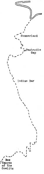
It was hot on the August day that we left the Paradise Highway but
the goal that had been set for the evening was Indian Bar, some sixteen
miles away. Crossing the lower portion of Mazama Ridge Reflection Lake
was reached in short order. Pinnacle Peak and several other crests of
the Tatoosh loomed to the south in the early morning light. "The
Mountain", to the north, was mirrored in the placed waters of this
glacial tarn, Reflection Lake, almost at our very feet as we skirted its
marshy edges. Here one finds a crew of engineers busily engaged in
constructing the end of what will eventually be the east side highway
(connecting Paradise with Yakima Park). Here also, at that time, one
also finds a considerable number of exceedingly predatious mosquitoes
who delight in the opportunity that a hatless and sleeveless man
affords. At the edge of an old glacial cirque immediately west of
Reflection Lake we gazed down to the waters of Lake Louise - also a
glacial tarn - and far down Stevens Canyon where one finds an old burn,
an object lesson to all that view it regarding care with fire in the
woods. The north slope of the canyon is bare and badly eroded; numerous
ghost-like snags that have withstood the ravages of time for some reason
or other, are the only vestige of the forest that at one time covered
the slopes of this canyon. The fire occured many years ago before the
white man had penetrated into this region and so its origin and date are
unknown.
|
|

|
The old burn, however, in spite of its being an eyesore in some ways
has much of interest. Many plants that appeal particularly to birds,
such as the salmonberry, are found along the trail in large clumps. This
attracts a wealth of bird life not usual at other points along this
trail. So down the trail through the canyon we go, the tall cliffs of
the Tatoosh at our right and Stevens Creek and Stevens Ridge at our
left. The Box Canyon of the Cowlitz, as usual, arrests our interest and
we pause at that point again to ponder over the power of this glacial
stream that has cut such a deep, narrow canyon and to listen to the
thunder of the waters of the stream as it roars through the narrow cleft
of its own making. Then Nickle Creek and the climb to the crest of the
Cowlitz Divide.
Throughout the several hours that the hiker spends along the trail
that follows the crest of this divide the mountain and all surrounding
country is laid out in one huge panorama. Many features are brought
into view from new and different angles and in consequence, look very
much different. Indian Bar, where the night has spent had not yet
emerged entirely from its blanket of snow. This broad glacial valley,
walled by tall cliffs is possessed of a great number of waterfalls, fed
by melting snows on the heights and these, together with the Ohanapecosh
River which pours over Wauhaukaupeuken Falls a short distance away, keep
up a steady roar and rumble that reverberates from the canyon walls. Up
with the sun we again were on our way climbing along a ridge toward
Panhandle Gap. Again wide vistas in all directions! Finally we strike
the snow that still lays deep in the region of the Gap. The trail
nearly blind here - cairns of stone only mark the route but now the
grade is easier and we make rapid time and soon have the Gap behind us.
Yakima Park lies in the distance on its familiar plateau. Below, with
straggling trees of timberline struggling up the mountainsides, lies
beautiful Summerland. A rest is taken to enjoy the beauty of the scene
and then down we go. Over snow fields and steep mountainsides switching
back and forth along the rocky slope. Finally we encounter the first of
the trees of timberline - a White-barked Pine. And soon we are in the
alpine meadows again - in Summerland. The noisy waters of Frying Pan
Creek are crossed and soon we plunge into the deep shade and silence of
the sombre forests of the lower slopes of the Park and shortly after
emerge upon the Yakima Park Road, our journey done. (C.F.B.)
Click to see a copy of the page
of the original article (~146K)
|