|
| ||||||||
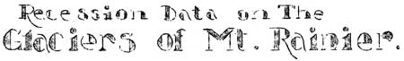
As has been the custom since 1918, the naturalist department of Mt. Rainier National Park began, on September 5, the annual tabulation of glacial recession on several of the largest or most typical glaciers on the flanks of "The Mountain". On that date the backward movement of the Nisqually and Paradise Glaciers was tabulated for the past year and, in addition, a point near the terminus of the Stevens Glacier was marked in order that data of a similar nature might be obtained for that "river of ice". The Paradise Glacier, at best but a lobe of the Stevens, has melted back to a point that renders it as merely a flank of the Stevens. More accurate future data will be made possible by a study of the Stevens rather than the Paradise. The famous ice caves of the Paradise will, in all probability, be but a memory in the future or, at best, only of very minor importance. The stream which flows from beneath the ice at the spot where the caves would ordinarily be found is now ab out one third of its former size. A large moulin was noted near the terminus of the Stevens, and this may indicate the presence of a small ice cave at that point although, as in the case of the Paradise, the topography of the earth and the thickness of the ice did not give evidence of any cave of major proportions. The Paradise Glacier is of a type known locality as a "dead" glacier; that is, one that has very little, if any, downward movement. More properly the term for this type of glacier would be glacieret or cliff glacier for the ice, at one time more extensive, has melted back to a basin high on the slopes of "The Mountain", and in this case it has been abandoned at the upper end by the more vigorous "living" Cowlitz Glacier that has cut below the level of the Paradise. The Paradise probably had its origin in the ice of the present Cowlitz some time in the distant past.
In September 1932, three points were selected at various places below the broad terminus of the Paradise, and from these, designated as "A", "B", and "C", measurements have been made since that time. The resultant data on the Paradise is as follows:
The recessional figure of the Nisqually Glacier for the past year is startling by comparison with the recession of previous years, but, in consideration of the very light snowfall on Rainier's upper slopes last winter and our early, open, and very warm summer, it is not out of line. This past year the Nisqually Glacier, by far the best known of Rainier's many "rivers of ice", set a new record with a recession of 155 feet! In other words, the melting at the snout, or terminus, was far greater than the replenishment of snow at or near its source high on the mountain. The greatest recorded recession of previous years was 188 feet, tabulated in the fall of 1930. Annual tabulation of the Nisqually's recession is as follows:
* Data from reliable historical accounts. On September 7 a trip was made to the snout of the South Tahoma Glacier. It was found that the appearance of the ice face, and its surrounding terrain, had changed materially in the past year. One flank, or lobe, to the left of the place where the stream issued forth and been practically destroyed by the rushing water of the river, and, in contrast to last year when a great amount of rock debris obscured a portion of the ice from view, the glacier presented a sheer ice wall with comparatively little morainal material on the steep face. The recession of the South Tahoma Glacier, in common with others measured, shows a marked increase for the past year, being 73 feet. Annual data is as follows:
As was expected, the Carbon Glacier receded less than any of the others. Protected from the intense rays of the sun by the high walls of its deep canyon, the ice melts correspondingly less. One may readily understand why the terminus of this glacier is credited with being the lowest perpetual ice in the United States (exclusive of Alaska). This glacier lies on the northwest flank of Mt. Rainier, arising in its great cirque at the foot of the Willis Wall. The first data on the recession of the Carbon Glacier was taken in September last year after several attempts to establish a permanent marker had failed. The results of studies carried on since the permanent marker was established in the fall of 1932 are as follows:
The Emmons Glacier, largest of Mt. Rainier and largest in the United States (exclusive of Alaska), lies on the northeast flank of The Mountain arising in the neve fields of the summit. Recession measurements have always been accompanied with some difficulty in this case due, largely, to the manner in which the form and position of the "snout" changed from year to year, and the difference each year in the point at which the stream issues from beneath the ice. This stream, which is the White River, emerges one year from one side of the snout, then from the other, and some years from the center, and, inasmuch as we have established the point of issuance of the main stream as the place to be considered as the actual terminus of the ice, this vagrant movement from year to year naturally causes some confusion. This year the stream had changed position again and so we decided to abandon the rule in the case of the Emmons and measure to the ice at the main mass of the snout farthest removed from the line of site. Recession data has been taken on the Emmons since 1931 - the line of site having been run in the fall of 1930 - and the results of the study are as follows:
The results of this year's glacial recession measurements indicate that the effects of the exceedingly dry year that is now drawing to a close have been noticed in the Pacific Northwest, where moisture is always abundant, as indicated by the recession of Mt. Rainier's great "rivers of ice". The light snowfall of last winter coupled with the long, warm summer brought about the excessive melting at the "snouts" of all of the glaciers measured. This was particularly noticeable in the case of the Nisqually Glacier which has set a recession record which will probably stand for many years. By way of explanation, this recession is the result of excessive melting at the terminus of the glacier. In the case of each glacier measured, except the Paradise, there is a definite downward flow as well. The glacier does not lengthen out or advance because the melting at the snout is greater than the accumulation of snow at the upper levels, hence each of these great ice fields is gradually growing smaller, year by year. C. Frank Brockman, | |||||||||||||||||||||||||||||||||||||||||||||||||||||||||||||||||||||||||||||||||||||||||||||||||||||
| <<< Previous | > Cover < | Next >>> |
vol12-11b.htm
01-Mar-2002