|
MOUNT RAINIER NATURE NOTES
|
| Vol. VII |
October - 1929 |
No. 12 |
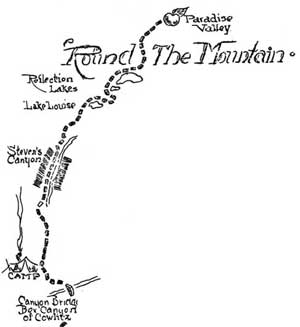
'ROUND THE MOUNTAIN
There's quite a lot of scenic wonderland compressed in these 324
square miles which we know as Mount Rainier Nat'l Park as anyone who has
traveled the Wonderland Trail will testify. Not only does such a trip
reward one with ever changing vistas of the old volcanoe as it is viewed
from different angles but its geological structure, its forests, its
flora and all phases of nature aid in making such a trip of never ending
interest.
|
We expected to be gone about 10 days but as a matter of fact but
seven were required. As we left Paradise Valley a light rain was
falling. Not so good. But Old Sol was going strong again when we
reached Reflection Lakes where autumn tints gave evidence of the coming
of that season. Huckleberries were ripe; the berries of the Mt. Ash
were a bright red and the leaves of the Low Bush Huckleberry showed
signs of the seasonal color change.
|
|
At Martha Falls we stopped to examine the basalt there and the
inclination of the basaltic columns which formed the cliff over which
this stream plunged to the narrow canyon below. The trail followed down
Stevens Canyon where, at some earlier date, a huge forest fire had
destroyed the timber. In places now forest was taking hold but the
hillsides were largely barren of trees. The first night found us at the
Government Trail Camp near the Box Canyon of the Muddy Fork of the
Cowlitz River. This canyon is full of interest. It is one of the
outstanding features of this section for it is only about 40 feet across
and 200 feet deep. On all sides, in the granite are evidences of the
tremendous grinding power of the glacier that once overwhelmed this
region. Now we find its snout over two miles removed from this
point.
STILL GOING - 'ROUND THE MOUNTAIN
|
Our destination for the next day was Summerland. Climbing to the
crest of the Cowlitz Divide we were rewarded all day long with wonderful
panoramas of "The Mountain". Noon found us at Indian Bar, above
Wauhaukaupauken Falls and in the alpine meadow just below the
Ohanepecosh Glacier, and from there on it was evident that the trail was
purely for scenic purposes; that grade was not considered. Following the
backbone of a ridge along the Fryingpan Glacier we passed through
Panhandle Gap -- a rough, rugged country above timberline -- crossed
several small fields of ice and snow and then dropped down over a steep,
rocky trail to the place of our second nights' camp in the upper levels
of Summerland. But the temperature that night did not fulfill the
promise of this Park's name.
|
|
|
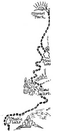
The distance of this second days travel was but 12 miles yet the
steep grades and little traveled trail made a hard trip out of it and so
the third night found us at White River Public Camp -- but 8 miles
distant -- where our horses were given a half days rest and a good feed.
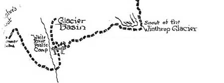
Mystic Lake was the next nights stop after climbing into Yakima Park and
skirting the broad snout of the Winthrop Glacier. Here we were able to
get an excellent view of Willis Wall -- and the next morning as we rode
out a great avalanche of ice came tumbling down over that huge
precipice. From where we were it appeared as though someone had thrown
a huge bag of flour over that cliff. We dropped down to skirt the snout
of the Carbon Glacier and then began climbing again to Spray Park. All
at once our horses decided to fight it out with a bunch of yellow
jackets -- and what a rodeo we put on! But other than that the trip
through Seattle and Spray Parks to Mowich Lake was an uneventful one.
Mowich is an Indian name for deer -- but we saw no deer at Mowich Lake.
We made ourselves at home in the shelter cabin there and the next
afternoon, after several skirmishes with more yellow jackets, we had
reached the cabin at Sunset Park.
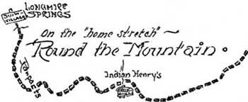
ON THE "HOME STRETCH" - 'ROUND THE MOUNTAIN
|
|
|
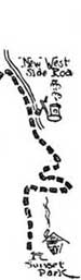
Not many miles beyond Sunset we struck the construction activities
which will eventually result in a highway along the west boundary of the
Park and after traveling the road several miles we turned on to the
trail to Indian Henry's Hunting Ground, which is regarded by many as the
most beautiful park on "The Mountain". Near there were a band of
Indians picking huckleberries in the manner of their forefathers who
ventured upon Rainier's slopes each year about that time in search of
these berries and to hunt. Now, of course, their activities are limited
to picking berries. And the seventh day found us riding the last six
miles, with light packs, skirting Squaw Lake, crossing Kautz Creek which
arises from the glacier of the same name, and descending from the
Ramparts to Longmire Spgs. on the Nisqually Road to Paradise Valley,
where the party disbanded. These few pages are too few to chronicle all
the interesting things seen and done on this trip. The miles were too
full of interest. One never sees this Park unless he tramps the trails.
We all can't make the Wonderland Trail but how much more would those
who drive hurriedly to Paradise Valley and back again know about this
mountain if they had spent just an hour or so on the trails?
The Wonderland Trail, as described on this trip taken by Dean Henry
Landes of the Univ. of Washington, Bob Anderson who was the packer and
the Park Naturalist, completely encircles "The Mountain" for a total
distance of about 97 miles.
|
Click to see a copy of the original pages of this
articles (~300K)
or view their 'Round the Mountain "map" (~55K)
|