|
| ||||||||||
| Intro | Author | Volume | Volume/Title | |||||||
|
Volume 1 - No. 2 |
October, 1939 |
|
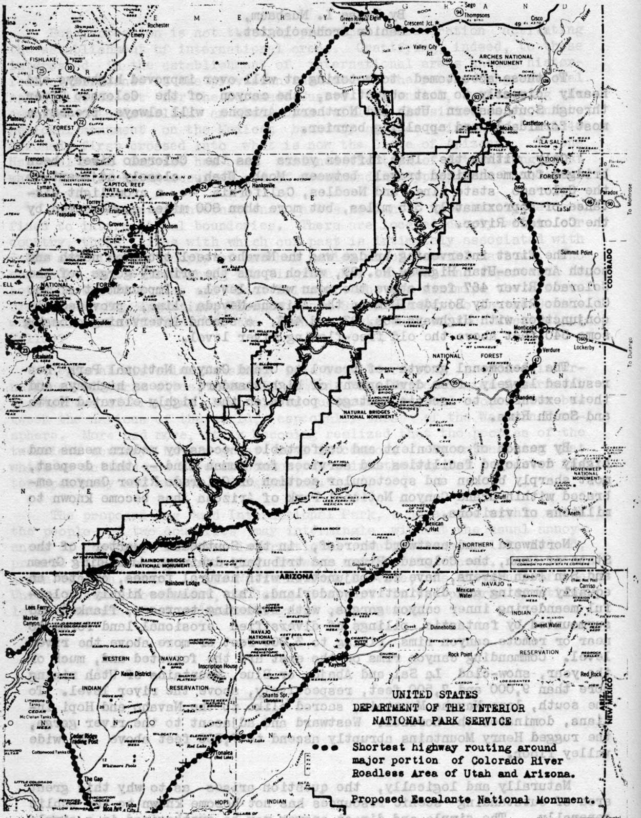
CERTAIN ASPECTS OF THE PROPOSED ESCALANTE NATIONAL MONUMENT IN SOUTHEASTERN UTAH By Jesse L. Nusbaum, To those accustomed to motoring at will over improved highways and nearly directly to most objectives, the canyon of the Colorado River through Southeastern Utah and Northern Arizona will always present a most formidable and appalling barrier. Only within the last fifteen years has the Colorado River been bridged for mechanized travel between Moab, Utah, closely adjacent to the Colorado state line, and Needles, California -- a crowflight distance of approximately 375 miles, but more than 800 miles as measured by the Colorado River. The first intervening bridge was the Navaho steel truss on north and south Arizona-Utah Highway No. 89, which spans the primary gorge of the Colorado River 467 feet above the mean water level. Impoundment of the Colorado River by Boulder Dam on the Arizona-Nevada line, provided in conjunction with Highways Nos. 93 and 466, a second intervening crossing some 540 feet above the old free-flowing river level. The phenomenal growth of travel to Grand Canyon National Park has resulted largely from development of high-standard access highways and their extension to scenic vantage points on the highly elevated North and South Rims. By reason of convenient and comfortable access by modern means and highly developed facilities and services for human kind -- this deepest, most sharply broken and spectacular section of Colorado River Canyon embraced within Grand Canyon National Park of Arizona has become known to millions of visitors. Northward and eastward thereof, in the Southeast quarter of the State of Utah, the Colorado River and tributary drainage, including Green and San Juan Rivers, have in conjunction with natural forces, created an equally amazing and distinctive wonderland. This includes highly colorful meandering inner canyon gorges, with bordering terraces, flanked and surmounted by fantastic pilings of diversified erosional land forms to near or remote canyon rims rising to 3,000 feet or more above the river level. Commanding canyon rims on the east are the forested and, much of the year, snow-clad La Sal and Abajo, or Blue, Mountains of Utah rising more than 9,000 and 7,500 feet, respectively, above the river level. To the south, lone Navaho Mountain, sacred alike to the Navaho and Hopi Indians, dominates the horizon. Westward and adjacent to the river gorge, the rugged Henry Mountains abruptly ascend to 7,500 feet above the wide valley floor. Naturally and logically, the question arises as to why this great area of outstanding scenic resources has not become known to the public generally. The simple and direct answer may be synthesized in a simple word -- inaccessibility for there are no present roads traversing the area from north to south or east to west.
Recourse to road maps of Utah and Arizona will promote understanding and realization of the immensity of this largest roadless area in the continental United States. Generally referred to as the Colorado River Roadless Area of Utah and Arizona, it has been estimated that it comprises 8,890,000 acres, approximately 13,890 square miles, after eliminating for a width of one mile to their ending, the few entering roads that encroach to, or beyond, the first barrier of this vast desert wilderness. To encircle it by motor over the most direct highways and unimproved desert and mountain roads, requires in excess of 750 miles of travel. Only for a few miles near the Moab, Utah, crossing of the Colorado can one see from the valley floor the great "Behind-the-Rocks" barrier wall of brownish red sandstone, gashed by the Colorado River, which marks the beginning of the main Colorado River Canyon and the northern boundary on the Colorado of the proposed Escalante National Monument. At no other point on the great circuit can one see, except remotely, any feature directly incorporated within the approximately one-seventh portion or heart of this great roadless area, which comprises 2,000 square miles of highest scenic values bordering the Colorado, Green, and San Juan River Canyons in Utah, and constitutes the proposed Escalante National Monument. Northward from the confluence the area includes the excessively entrenched meanders of Labryinth and Stillwater Canyons of the Green River for an airline distance of 42 miles to influent San Rafael River; the Canyon of the Colorado, for 33 miles, to its boxing in, on the edge of Moab Valley; and the southern portion of the great intervening plateau promontory, known locally as Great Flat and Gray's Pasture, which separated the rivers. This area, from elevations approximately 3,000 feet above the river levels, provides a comprehensive scenic command of the northern and most highly colorful half of the proposed Escalante Monument. Southward from the confluence for a crowflight distance of 120 miles the proposed monument area averaging 13 miles in width, is more or less evenly balanced along the medial line of Colorado River meanders, enlarging to embrace the outlying "Little Rockies" of the Henry Mountains, and a greater width of deeply sculptured sandstone ledge on the north side of influent San Juan River. Below the confluence of the San Juan, the area includes only the west and north sides of the Colorado River for an average distance of 5 miles to just below the "Crossing of the Fathers", since the opposite side is incorporated within the Navaho Indian Reservation. Here at the "Crossing of the Fathers", in the closing months of 1776, Father Escalante, courageous Franciscan Friar, and his small band of followers, finally succeeded in descending to, and crossing, the Colorado River as they returned half-starved and defeated in their futile effort to open a trace from Santa Fe to Monterey on the Pacific Coast. Former Superintendent Tillotson of Grand Canyon National Park, who conducted and reported the initial survey of the Upper Colorado River Canyon for the National Park Service, suggested the name of Escalante for the much larger area then proposed to commemorate this notable first crossing by white man of the Colorado River Canyon. Fortunately for those who largely depend upon mechanized transport, and that includes most of us, the Division of Grazing of the Department of the Interior, in cooperation with the Civilian Conservation Corps, has within the past two years, progressively developed an entering truck trail from Highway No. 450 about 17 miles north of Moab to serve the interests of the few cattlemen who graze stock atop the great wedge-shaped promontory between the Green and Colorado Rivers. Branching at the Knoll, about 22 miles west and south of the highway connection, the left-hand truck trail continues southerly approximately six miles to a terminus at Dead Horse Point. This is a protruding and tapering finger of the great plateau which projects a mile or more into the Colorado River Canyon beyond the great bays which it separates, and ends in all but detached sheer-walled, butte-like formations, perhaps a half mile in circumference at its top. From the periphery of the rim of Dead Horse Point which must be traversed on foot from the connecting neck, scenic command is superb in all directions. About 70 miles of great Colorado River Canyon are visible from this point. Seemingly to greet you, the Colorado River swings northward to complete an entrenched hair-pin meander at the very base of the abruptly towering 3,000 feet high formation on which you stand. In no other area in America, to my knowledge, can one see so vast an exposure of highly eroded red-bed formations, nor greater range of reddish hues from deep maroons through to buffs. Shades of red are favored colors. Plan to reach Dead Horse Point by three o'clock in the afternoon and remain for sunset. In the course of the past two years, it has been my pleasure to conduct, or accompany, several hundred persons to Dead Horse Point, and remotely from Mesa Verde and elsewhere, to stimulate visits of an equally large number of national park and monument visitors. The views of Colorado River Canyon from Dead Horse Point, alone, have admittedly convinced even the most skeptical of the scenic merit of this National Park Service proposal. Landscape Architect Merel Sager of the National Park Service, who was in charge of its second field investigating party, in his report to Director Cammerer relating to the proposed Escalante National Monument, stated that: "The colorful canyons of the Colorado and Green Rivers, without question, constitute the paramount landscape features in the entire area, and their existence alone supplies sufficient justification for the creation of a national park. "In these days, it seems we hear more about the recreational values of the national parks than we do about their spiritual values. They are related, to be sure, but it is the potential capacity of our national parks, with their inherent endowment, to supply spiritual values which distinguish them from the multitude of other recreational areas. The canyons of the Colorado possess this quality to a marked degree, and for many reasons. There is color, glorious color; 200 miles of countless fantastic, weird monuments and pinnacles, limitless in variety of form, slowly yielding to the relentless forces of wind and water. Here is the Colorado, mysterious, treacherous, forbidding; carving its meandering way through red sandstone canyons, so rugged that they have thus far successfully defied east and west commmutation of human kind in the whole of southeastern Utah. Here is desolation., solitude and peace; bringing man once more to a vivid realization of the great forces of nature. Yes, the canyons of the upper Colorado have spiritual and emotional appeal equal to that supplied by most of our national parks." | |
| <<< Previous | > Contents < | Next >>> | ||
|
region_iii_quarterly/vol1-2h.htm Date: 17-Nov-2005 | ||||