|
| ||||||||||
| Intro | Author | Volume | Volume/Title | |||||||
|
Volume 3 - No. 1 |
January, 1941 |
|
THE BIG BEND OF TEXAS By Dr. Ross A. Maxwell, Te reach the Chisos Mountains in Texas by automobile, one must travel 80 miles from Marathon, or approximately 110 miles from Alpine, in the southwestern end of the state. A few miles south of Marathon, pinkish-white and yellowish-white ridges will be seen on each side of the road. These were laid down in a horizontal position in the bottom of an ancient ocean that at one time covered that part of the continent. After many years these rocks were folded into mountain ranges, believed to have been formed contemporaneously with the Appalachian Mountains. The rocks in these mountains were subjected to weathering. The rain fell, the wind blew, and the rocks were broken up and carried away by streams until only the roots of this mountain range remained. Many years later, during a period of the earth's history that geologists call the Cretaceous, the sea again advanced over this area and buried the old mountains under several hundred feet of Cretaceous sediment. Since then, erosion has stripped away the Cretaceous rocks, and again the roots of the old mountain chain are exposed. Continuing south from Marathon there is a mountain range on the west side of State Highway 227 that extends from the approximate latitude of Marathon on the north, southward across the Rio Grande into Mexico. The northern half of the range is called the Santiago Mountains, and the southern half, the Sierra del Carmen. Local usage has popularized the term "Dead Horse Mountains" for the southern half of the Texas portion of this range.
About 40 miles south of Marathon, the highway passes through an opening in this mountain range; this is Persimmon Gap, the entrance to the proposed Big Bend National Park. If you stop at the highest point in Persimmon Gap and look around, you will see rocks that were deposited during the same geologic era as those a few miles south of Marathon. This is a second exposure of that ancient mountain range that was formed millions of years ago. The upper walls in the gap are formed of Cretaceous limestones and shales that were deposited in the ocean which covered the old mountain range. As you pass from the gap the largest group of mountains on the right is the Rosillos, so named because of the roan color. Almost in front, but slightly to the right, is the largest and highest mountain group in sight. These are the Chisos Mountains, meaning "Ghost" or "Phantom" mountain. These rugged peaks are the highest in the area and rise to approximately 8,000 feet above sea level. After leaving Persimmon Gap, the highway fellows parallel to the Santiago Mountains (on left). If the car has been moving at a normal rate of speed, you should soon see on the left a sharp narrow canyon. This is Dog Canyon, or Bone Gap, and is the dividing feature between the Santiago Mountains on the north and the Sierra del Carmen (Dead Horse Mountains) on the south. It is about 200 foot deep and averages 75 feet in width. A dim auto road turns off the highway to it. On the west side of the mountain about two miles south of Dog Canyon (left of highway) is another narrow canyon that averages 50 feet or more in depth and in places is less than 10 foot in width. This is Devil's Den, or Devil's Canon. You will soon be riding over a road where there are several dips. These have been cut by streams that flow down the western slope of the Sierra del Carmen. The running water is able to carry a big load of rock debris down the mountain side, but when the stream reaches the gentle slopes at the foot of the mountain, the load is deposited. This surface that slopes from the mountain is virtually all composed of rock fragments that have been washed from the tops of the Sierra del Carmen. A short distance farther there are a few exposures of gray limestone. This stratified rock is the Boquillas flagstone. it was deposited in the Cretaceous sea, and, with the materials that compose the flagstone, there are thousands of fossil shells of oysters, clams, snails, corals and sea urchins. These animals lived in the ocean and when they died their shells fell to the bottom and were petrified in the rock. Some of the fossil oyster shells are unusually large. It is not uncommon to find them 18 inches in diameter. One fossil clam 49 inches in length has been found. When you have driven about 55 miles from Marathon, the road will lead diagonally across a flattish area. This is Tornillo Flat. The soil is very impervious to water. The rainfall soaks into the upper few inches of the soil and makes a very sticky mud. When the water dries, the mud cracks and breaks into little pellets. This area is the desert of the Chisos country. During the dry season, there is little vegetation except creosote bush and lechuguilla, but following a shower the plants spring up as if by magic. In a few days they are in blossom and the desert is clothed in a robe of gorgeous colors. This vegetation lives for only a short time. Following the next shower, new and different kinds of flowers appear. This procedure continues throughout most of the year.
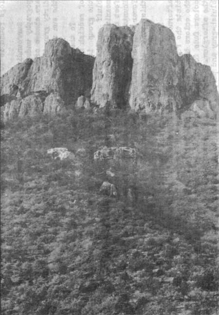
In Tornillo Flat there are several sandstone hills and ridges. In and around them are petrified logs and the bone fragments of dinosaurs. The dinosaurs roamed over this country about 100 million years ago. Some of the unfortunate monsters became stuck in the mud and died. Their bones were covered with mud and water and were later petrified. Weathering and erosion have uncovered the bones and we now find them on the surface. Contemporaneous with the dinosaurs were forests, and likewise some of the trees were petrified. Many fragments of wood and some logs may be seen nearby. The largest of the logs found is 10 feet in diameter. Surrounding Tornillo Flat is a rough, hilly belt of bad land topography underlain by sandstone and shale with brilliant colors. There are shades of purple, red, brown, pink, white, black, olive drab, and dirty gray that occur in bands sharply separated from each other. As the sun shines on them, they remind one of the Painted Desert. To the left of the highway, southeast of Tornillo Flat, is a belt of reddish hills. These are the McKinney Hills. The highest peak in the group is Roy Peak, beyond which is a vertical westward-facing bluff on the west side of the Sierra del Carmen. It is Alto Relex, meaning high bluff. South of the Rio Grande is a vertical cliff 2,000 feet or more in height that is a continuation of the Sierra del Carmen Mountains, The small high peak at the top of the bluff is called Shot Tower, used by surveyors when the various land surveys were made of this area. It is now a land mark. The sunset on the Sierra del Carmen is a gorgeous sight. In the afternoon when there are wispy clouds in the western sky, the sunlight tints the rocks in this range an orange-colored glow. As the sun sets the colors brighten to a brilliant red. After the sun disappears the colors fade for a brief period to be temporarily brightened again by the afterglow. Eventually, however, the colors change to pink, then bluish-gray and purple. These colors remain after the light has disappeared from the other mountains, gradually fading into the neutrality of twilight and then changing to the blackness of night. The highway continues across the flat to Tornillo Creek, a broad dry wash, except after a rain, when it becomes a treacherous torrent. A few miles farther the highway forks the loft fork goes to Glenn Springs, Boquillas, San Vicente, Mariscal Canyon, Johnson's Ranch, Castolon, and other points of interest along the Rio Grande. Glenn Springs is the headquarters of a ranch, and is an overnight stop for inspectors of the U. S. Immigration Service. Only a few years ago, however, it was a thriving community. In 1918, when Pancho Villa was active across the river, there were two companies of U. S. soldiers stationed in Glenn Springs. When the trouble subsided all but nine of the soldiers were withdrawn. Then, on the night of May 5, 1916, (Cinco de Mayo), a group of bandits from across the river made the raid which is locally referred to as the Glenn Springs massacre. Three American soldiers, a small boy whe lived there, and a number of Mexican bandits were killed. The old adobe house that was used as a fort, the store building, and several other houses still remain. In some of them bullet holes can still be seen. Boquillas, located on the Texas bank of the Rio Grande, is occupying its third site. At one time it had a post office, in days when the village marked the end of a stage line, and was a stopping place for travelers from Mexico. Now there are less than half a dozen homes, and only a few children to attend its public school. Though seldom used as such, it is still a port of entry. The traveler wheo stops there can be assured of an excellent meal in the isolated wayside inn. The head of Boquillas Canyon is a short distance down the river from the village. This canyon was cut by the Rio Grande across the Sierra del Carmen ranges. It is noted for its depth, narrowness, and the sheerness of its walls. It was near the head of this canyon, in 1882, that Captain Charles Neville and his Texas Rangers came upon a band of Indian raiders. The Rangers' ammunition supply was low and much of what was left was used in firing at the Indians whe took to the mountains without their horses. The rangers were traveling by boat. They didn't want to leave the horses for the Indians te remount and ride in further raids against the settlers. Ammunition was too valuable to be used in killing the animals so the horses were blindfolded and knocked in the head. Since that time some people have referred to this canyon as the Dead Horse Canyon. The right fork of the road, beyond Tornillo Crook, leads to the Basin of the Chisos Mountains, whore the proposed Big Bend National Park headquarters will be established. At this point the speedometer should register 66 miles from Marathon. Here one can get a good view of the Chisos. The farthermost peak on the east (left) side of the Chisos is Nugent. The next one from left to right is Pummel, so named because of its similar shape to the pummel of a saddle. The next peak is Panther Peak, and the higher peak behind Panther is Lost Mine Peak. The big square-topped mountain in the gap to the right of Lost Mine is Casa Grande (big house), and the large bluff on the right side of the road is Pulliam Mountain. Near the road on the left hand side is a mountain that stands away from the rest of the Chisos group. This is Lone Mountain. About 6 miles farther the highway passes the two ranch houses near Government Springs, from where there is a good view of the Christmas Mountains. They lie 12 to 15 miles to the northwest. The Paint Gap Hills, a low belt of red hills, lie about four miles north of Government Springs. A short distance past the ranch houses the road forks again. The right hand fork (Highway 227) goes to Terlingua, a quicksilver mining district outside the park area.
Terlingua is a quaint Mexican village, where the chief period of celebration is Cinco de Mayo, May 5, in observance of the Mexicans' defeat of Maximilian. A few days before this holiday, the houses, cemetery, and community center are decorated. A baile (dance) is usually held and the villagers come in their best costumes. The dance is at the community center, a small house with outdoor concrete dance floor. Current for electric light is provided by windchargers. The musical instruments are usually violin, guitar, and harmonica. The baile may continue throughout the night. It frequently extends into the following day and night. It is a gala occasion and very few of the natives ever miss it. The left hand fork goes to the heart of the Chisos Mountains, through Green Gulch. Pulliam Mountain is on the right; a spur of Lost Mine Peak is on the left, and Casa Grande, near the head of the gulch. The road, although it may look level, is uphill all the way. Most cars have to use second and low gears before they reach the top. When you reach the top of the divide, and start down, you obtain the first view of the Basin, a depression in the heart of the Chisos Mountains. The floor of the Basin is approximately one mile above sea level. It is completely surrounded by a mountain wall l,000 to 3,000 feet high. As the road winds down to the headquarters area, whrre the CCC Camp is now located, you may look through a gap in the mountain wall - the Window - and see across the desert lands of the Big Bend, and on for miles into Old Mexico. The image of old Chief Alsate (Ol-set'-ee), legendary Apache watcher of the Chisos, has been carved by nature in a volcanic rock formation and can be seen from the mouth of Green Gulch, south of Government Springs. Though lying on his back atop the massed remnants of a boiling river of destruction, his head is elevated and he is facing Lost Mine Peak. The local legend is that to find the "lost mine", one must cross the Rio Grande into Mexico and there, opposite San Vicente, Texas, in the early morning hours of Easter Sunday, stand in the doorway of the ruins of San Vicente Presidio. As the sun rises over the Del Carmen Mountains, at the back of the hopeful watcher, it is supposed to shine directly into the mine's doorway, "somewhere" on Lost Mine Peak. From the Basin one may travel by horseback to the South Rim of the Chisos Mountains. This rim has an elevation of more than 7,000 feet and is approximately one mile above the Rio Grande, 16 miles to the south. From this point of vantage on a clear day, one may see for a distance of at least 100 miles, a panoramic view of one of the last frontiers and one of the finest in the Southwest. | |
| <<< Previous | > Contents < | Next >>> | ||
|
region_iii_quarterly/vol3-1d.htm Date: 17-Nov-2005 | ||||