|
| ||||||||||
| Intro | Author | Subject | Volume | Volume/Title | NPS | |||||
|
Volume I - No. 1 |
July, 1938 |
|
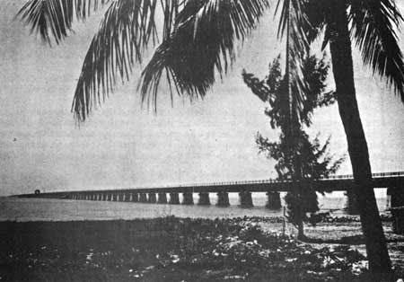
A HIGHWAY OVER THE SEA By C. R. Vinten, The Civilian Conservation Corps is being introduced to a new type of conservation problem as Camp Fla. SP-11 sets up its new quarters on West Summerland Key. The camp site selected on this coral island is 40 miles northeast of Key West. Those who have been used to surroundings of limitless stretches of terra firma will work on small fragments of the tropics which form a narrow chain across a brilliantly colored ocean. The Overseas Highway crosses the eastern corner of the proposed Everglades National Park, below the town of Homestead, and follows the old line of the Florida East Coast Railway. The right of way and bridges of this railroad were purchased by the State for $640,000, which was part of a $3,500,000 loan made to the State by the Public Works Administration.
The balance of these funds was set aside for construction of nearly 14 miles of bridges and 30 miles of road over narrow keys, which have closed a gap formerly traversed only by the railroad and ferry. Modern concrete bridges, which have been constructed on the piers of the old railroad bridges, are now open to vehicular traffic and provide a continuous drive from Miami to Key West. The opening of the Overseas Highway has made available a portion of our country which is unique from the standpoint of geological formations, tropical growth, and wildlife species. At times, the Highway runs through low tropical jungles, across keys which are surrounded by more distant keys, and suddenly emerges from this enclosure to traverse long bridges which cross open expanses of clear water. The coloring of these waters fades from deep blue to vivid green and brown, offering a real thrill to the traveler. Occasional forests of coconut palms, agaves and thatch palms make one feel that he is traveling through the South Sea Islands. The Secretary of the Interior and the National Park Service have taken a keen interest in this stretch of Highway and have offered to co-operate with Florida officials in planning for the control and protection of this 100-mile parkway. To this end, various state agencies have been coordinated for the purpose of developing a joint program of development. Fred Elliot, representing the Trustees of the Internal Improvement Fund - the state agency responsible for state-owned lands - has been designated as the responsible official in connection with land acquisition. John R. Slade, Chairman of the Overseas Road and Toll Bridge District, and B. M. Duncan, Chief Engineer and General Manager of the Overseas Road and Toll Bridge District, have been designated as representing agencies interested in the Toll Bridge District of 44 miles - the stretch between Lower Matecumbe Key and Big Pine Key. T. B. Massie, Engineer-in-Charge of Roadside Development, has been designated to represent the State Road Department. H. J. Malsberger, Director of State Forests and Parks, has been designated as coordinator of state agencies in dealing with the National Park Service. He also has been designated as Park Authority for the CCC camp now being established. The National Park Service will cooperate with these agencies through Mr. Malsberger on the same basis as on the development of state parks. Preparation of property maps and master plans has begun under the able supervision of Project Superintendent W. L. Phillips of Camp Florida SP-9, South Miami, Florida. Mr. Phillips is a highly qualified landscape architect, and has had many years of experience on similar problems in the tropics. It is encouraging to note the enthusiastic support which has been given the recommendations of the National Park Service throughout the preliminary conferences on the Overseas Highway. Every agency concerned with the problems of the Florida Keys realizes the importance of preserving the distinct character of this area and its value as a national asset. The flow of tourist travel to the south will unquestionably make this scenic drive one of the goals of the vacationist. Unrestricted private development is, therefore, anticipated and all agencies concerned are interested in taking immediate steps to acquire broad rights-of-way, scenic easements and adequate land acquisition, in order to guide development in the proper direction. Plans for future development and control are being based upon the fundamentals of conservation, rather than upon physical development. The first and immediate problem being considered is that of acquisition. Second to this problem will be that of preservation from the standpoint of a scenic parkway. The third consideration will be that of locating use facilities in such a way that the general character of the Florida Keys will be least disturbed. Plans have not progressed sufficiently to be able to dictate the exact course of State work. The principal steps have been taken, however, and it is hoped they will lead to the establishment of one of the most scenic drives in the world.
| |
| <<< Previous | > Contents < | Next >>> | ||
|
regional_review/vol1-1c.htm Date: 04-Jul-2002 | ||||