|
| ||||||||||
| Intro | Author | Subject | Volume | Volume/Title | NPS | |||||
|
Volume II - No. 4 |
April, 1939 | |
|
THE NATCHEZ TRACE - AN HISTORICAL PARKWAY By Malcolm Gardner,
When the white man began his exploration of what is now the southern United States, he found ready-made for his travels a network of Indian paths linking village with village and tribe with tribe. These trails showed a marked tendency to follow watershed divides in an effort to avoid stream crossings and swamps, in spite of the circuitous windings of such routes. Several of these trails, though individually not of outstanding importance, when joined together led in a northeasterly direction from the present city of Natchez, in southwestern Mississippi, to the Middle Tennessee country. Thus the component parts linked the important tribes of the Natchez, Choctaws, and Chickasaws. Toward the north, the trail touched the western claims of the Cherokees. This route gradually increasing in importance became known to later history as the Natchez Trace. That a few of these Southern trails became much more important than other paths through the forest was due to the military, political and commercial activities of white men pushing north from the Gulf of Mexico and west from the Atlantic. By about 1716 the French had a trading post and a fort, Rosalie aux Natchez, high on the bluffs of the Mississippi and dominating the Natchez Indians. Plantations and a settlement followed closely. The massacre of the garrison and settlers at Fort Rosalie by the Natchez in 1729 led to the dispersion and virtual destruction of this tribe, whose complicated social structure and religious ceremonies have been described in considerable detail by amazed French observers and still constitute a fascinating story for historian, anthropologist, and Sunday supplement reader alike. Of greater importance than the Natchez in the story of French colonial expansion in the Mississippi Valley were the pro-French Choctaws and the pro-British Chickasaws. Here the world-wide struggle of France and England for imperial dominion was fought out on a small scale as colonial officials and Indian traders guided the war-like predilections of their red allies. When a remnant of the hunted Natchez fled through hostile Choctaw territory to take refuge with the Chickasaws, Lemoyne de Bienville, Governor of Louisiana, set his energies toward completing French revenge on the Natchez and crushing the Chickasaws, and doing both with one blow at the center of the Chickasaw power. Their villages were concentrated in a prairie section still called the Chickasaw Old Fields in present-day northeastern Mississippi. While Bienville gathered his French militia and Choctaw tribesmen, Pierre d'Artaguette, commandant at the Illinois posts, marched south with four hundred men, two-thirds of them Indians, to effect a junction with Bienville. The two forces were never joined, but defeated in detail within a week of each other in May 1736. Bienville reported that English traders aided in repulsing him before the fortified village of Ackia. The defeat was a blow to French prestige, and France never attained to complete domination over the territory between the Mississippi and the Appalachians. In the latter half of the eighteenth century the Spanish came into possession of much of France's territory in the Mississippi valley. England held the Natchez district from 1763 until ousted by the Spanish in 1779, while the young United States succeeded to English claims along the Mississippi at the close of the American Revolution. Two outposts of these conflicting forces were Natchez, a northern center of Spanish power in the lower valley, and Nashville, the western spearhead of settlement of the new American Republic. Five hundred miles of wilderness separated these two settlements, but the common economic interests of the Mississippi valley attracted them toward each other. The link by land between the two points was the Natchez Trace which traversed parts of the present States of Mississippi, Alabama and Tennessee. It was used extensively by frontiersmen returning home after having floated their produce down to New Orleans. With American occupation in 1798 of the Natchez district, long in dispute between Spain and the United States, Natchez assumed a new importance in American eyes as a step toward the domination of the Mississippi valley, and added importance was attached to the Natchez Trace as a military and political line of communication with this southwestern outpost of the republic. A post road was established early in 1800, and--as the Post master General complained--"at a great expense to the public on account of the badness of the road which is said to be no other than an Indian footpath very devious and narrow." He suggested to the Secretary of War that United States troops stationed in the southwest might advantageously be used "in clearing out a waggon-road and in bridging the creeks and cause-waying the swamps between Nashville and Natchez." Late in 1801 treaties were negotiated with the Chickasaws and Choctaws by which they agreed to the improvement of the route. General James Wilkinson, commanding the United States army in the West and one of the commissioners for treating with the Indians, immediately prepared a map of the Natchez Trace and closed his description of the survey with the statement: "This road being completed I shall consider our Southern extremity secured the Indians in that quarter at our feet and the adjacent Province laid open to us." He made one important change in the old trail by moving the crossing of the Tennessee River from Bear Creek to Colbert's Creek, several miles up the river. Early in 1802 the troops were at work on the road through the Indian country, the boundaries of which were the Duck River Ridge, 30 miles south of Nashville, and Grindstone Ford on the Bayou Pierre to the north of Natchez. The acquisition of Louisiana and the establishment of New Orleans as the territorial seat of government increased the need for better postal communication with that city. In 1806 a Congressional appropriation of $6,000 was made for the improvement of this route under the direction of the Postmaster General. Francois André Michaux, scientist and western traveler, wrote that the work of the army had shortened the route from Nashville to Natchez by 100 miles. The Postmaster General estimated that the survey to be followed in the new improvements would reduce the distance by 50 miles more. Thus the less directional of the ridges were abandoned, and the distance was shortened by bridges and causeways to expedite communication and the passage of the mails. Like a stream with an increased current, this road cut new channels for the volume of its traffic, but still it remained the Natchez to Nashville road, the Natchez Trace.
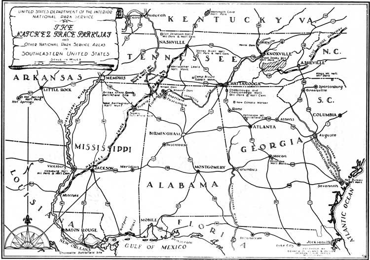
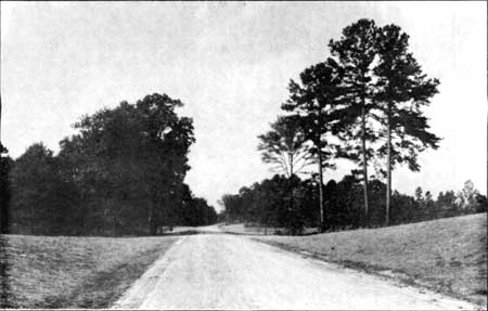
Along this road passed pack horses and Kentucky boatmen; outlaws lay in wait for the unwary traveler; and a few early tourists such as Francis Baily and Dr. Rush Nutt vividly described the hardships of the journey. A few inns, or stands as they were usually termed, were opened to care for travelers along the Trace. At Grinder's Stand Meriwether Lewis met his death in 1809. Early in 1813 after his Tennessee militia was ordered disbanded at Fort Dearborn, near Natchez Andrew Jackson moved these troops north over the Trace and earned the devotion of his men and the sobriquet of Old Hickory by his untiring attention to their needs during the hardships of this winter march. In 1814 reenforcements for Jackson at New Orleans came south over the Trace, and a considerable part of the victorious army returned to Tennessee over the same route. In 1816 both the Choctaws and Chickasaws relinquished lands in the Mississippi Territory. Settlers from the older settled areas on the north and east poured into the newly opened lands, and the pressure of these newcomers wrung additional territorial concessions from the Indians. In 1820 by the Treaty of Doak's Stand, at the old Choctaw Agency on the Natchez Trace, the Choctaws surrendered more territory, and finally in 1830 at Dancing Rabbit Creek they surrendered the remainder of their lands east of the Mississippi. Two years later at Pontotoc Creek the Chickasaws agreed to cede their lands and move west of the river. As the population had grown and new settlements had sprung up, additional roads were required and traffic was diverted into new channels. Jackson's Military Road, Gaines' Trace, the Boliver Trail, a southern route through Georgia, and a number of others were cut through the forests and causewayed over swamps. The development and improvement of the steamboat, however, gave the main blow to most land travel for long distances. The Natchez Trace lost its importance as a through route; sections of it were abandoned while other parts became neighborhood roads and links between small settlements, as was the case before the white man's coming. The cycle had swung a full turn. The significance of the Natchez Trace lay in the political, military and economic importance of the two towns of Natchez and Nashville at the close of the eighteenth century and in the opening years of the nineteenth. Perhaps the importance of these two places was the accidental result of a temporary stalemate of conflicting forces in the Mississippi Valley -- French and British, Spanish and American, Indian and White -- but the Trace came nearest to a practicable all-weather route without requiring the construction of large numbers of expensive bridges and causeways. It served, therefore, as an avenue of American expansion in the old Southwest. To date no evidence has been revealed to show that it was not the first national road, the first of internal improvements resulting from support with the material resources of the central government and with direct appropriations by Congress. The above outline of the history of the Natchez Trace and of some of the events occuring in its vicinity is a very brief summary of the results of an extensive research project conducted on this subject. The procedure in securing documentary materials followed the conventional practices advocated in the academic seminar. Official documents of the United States and of Tennessee, Alabama, and Mississippi, manuscripts as well as publications, were examined, and some of the most interesting material came from the unpublished records of the War Department, the Office of Indian Affairs, and the Post Office Department. In the Library of Congress the Manuscript Division, the Map Division, the Rare Book Room and the Local History Section all offered considerable material. Among several maps secured from the files of the War Department was General Wilkinson's survey of the Natchez Trace. From the General Land Office came the township plats of the early rectangular surveys, scaled two inches to the mile and showing the Natchez to Nashville road and adjacent sites through most of its three hundred mile length in Mississippi. In many cases the field notes of the surveys accompanied the plats. Two unpublished maps showing in detail the location of certain Chickasaw villages were secured from the French national archives. Such was the type of material from which was written the story of the Trace and its associations. The story of a place or an event is one thing; its exact geographical location is still another matter. The problem of locating on the ground the route of the old Natchez Trace and the sites of adjacent points of historical interest involved to a considerable extent certain technical skills. Map scales had to be translated from leagues and toises to miles and rods and then applied to a conjectural location on the actual ground. Map indications of streams, trails, prairies, and hill contours required hypothetical identification with the originals and the verification of other maps and then correlation with any available written descriptions. The map makers of the eighteenth century were not marked by that passion for accuracy which characterizes the technical work of our present mechanical age. Even on the large scale survey plats of the 1830's and 1840's the field investigator would be forced occasionally to disregard the evidence of the map as interpreted by its compass points. If the map indicated a road running southeasterly while a study of the ground showed a usable ridge running south by southeast with very rough and broken country stretching out on either side, then the judgment of common sense dictated the decision that the old road followed such a ridge. The evidence of the map had perforce to be abandoned. While the general route of the Natchez Trace was well known, considerable uncertainty existed as to its exact location in a number of places. In the work of field location consideration was given therefore to all available evidence -- documentary materials, maps, survey plats and notes, local tradition, and physical remains or road scars in the ground. Certain places which could be easily located along the old road as stream crossings, important sites, and intersections with township lines, were used as control points and the work of location carried on in detail between them. The township plats of the Congressional or rectangular survey were basic data in most of Mississippi and Alabama. In the Old Natchez District in southwestern Mississippi and in Tennessee the random land grant system prevailed, and a considerable amount of location was based on such local records as old deeds and land surveys, which might mention the Natchez Trace or the Road to Nashville or the Post Road as a property line for adjacent lands. The minutes of a county court concerning repairs or relocations sometimes gave information about the early location of the road. One apparent contradiction in its location as shown on the maps was solved, after field study, as being a route along a roundabout ridge for wet weather, but with a short cut through the bottoms for dry weather. And of course certain of these differences represented changes in its route as time passed. As finally flagged on the ground, the location of the Trace includes for the most part the revisions of 1806 and after, since these improvements constitute the route appearing on later maps and particularly on the survey plats. Congress has authorized the construction of a parkway along the general route of the old Natchez Trace, designed for tourist and passenger car traffic. Presumably the Natchez Trace Parkway eventually will be one section of a national parkway system of arterial routes for passenger cars. A parkway is an elongated park containing a road, and a parkway as a part of a comprehensive recreation and conservation program would make available to the traveler certain areas along its route of a scenic, scientific, and historical importance. On the Natchez Trace Parkway historical features will be emphasized although final plans for preservation and development are far from complete. In the first place this parkway itself is a memorialization of the old Natchez Trace and bears its name although technical standards required for modern traffic do not allow it to follow closely all the crooks and turns and some of the narrow ridges of the old road. Plans are now being made, however, for the preservation of a 10-mile stretch of the old Trace. In the loess soil in south eastern Mississippi the effect of considerable traffic combined with gradual erosion had cut the old roadbed deep into the ridges on which it runs. So slow has this process been that the steep banks on either side have been stabilized to depths of 10 and 15 feet by the roots of small vegetation. Overhead the tree branches form a high arch. So narrow are some of these sections that vehicles could not pass each other. It may be asked whether this is history or landscaping, and the question may be answered by saying that the preservation of such a section of the Trace is a charming re-creation of the old road and of its historical atmosphere*. Toward the Natchez end of the Parkway is the Selsertown Mound of unique formation and probably constructed by prehistoric occupants of that area, but showing evidence of later Natchez occupation. Within three miles of Natchez are the Natchez Indians. These areas seem worthy of inclusion within the parkway lands and of preservation for archeological study at some future time -- perhaps 10 years, perhaps 100 -- when their artifacts may be displayed and the history of their builders related with suitable museum facilities, since much of the social and economic history of a people is explained by the objects used in their daily lives. Two hundred and fifty miles north of the Natchez lay the center of Chickasaw power. Congress already has authorized the Ackia Battleground National Monument. This is the proper place to present the history of that nation, and there is much more to Chickasaw history than a recital of tribal wars and white aggressions. The anthropologist and the archeologist are also historians, and the present-day techniques of museum display will allow a presentation of historical material with a high degree of scientific as well as popular interest. The white settlement of the old Southwest offers some interesting possibilities in the presentation of historical material. Fifteen miles east of Natchez stands an unpretentious farm house, known as Mound Plantation. The earliest part of the building was constructed about 1790 by a Scotsmen unknown to fame, who had obtained a Spanish land grant of some 600 acres. The house served as an inn along the Trace; gradually slave quarters, an overseer's house, and a guest house were added to the plantation messuage. The house has no architectural merit. It is as undistinguished as its builder. Yet it and its first owner well represent the common people who came into this newly opened country seeking to exploit the land, to acquire slaves and lands and houses and still more slaves and more lands. This was the southwestern agricultural frontier where cotton became king and gentry was created, in one generation. Also in and around Natchez is another and later style of architecture, graceful and delightful, highly ornamental, and expensive to maintain in the social station to which it was accustomed. This was mainly Greek Revival form, with occasional French and Spanish influences, and in its parlors and drawing rooms presided a ruling class. All this, too, is American history. The interpretations of the architect may well rank him also as an historian. The history of the Natchez Trace, of the sites along its route, of the cultural and economic tides flowing through the country it served, would seem a proper concern of the national government and of its citizens. Such a story transcends the narrow bounds of politics and warfare, and deals with a variety of man's activities. With the disciplines of the anthropologist, archeologist, and archeologist, and architect as an aid and with the skill of the museum technician for the preparation of visual interpretations, history has an interest and a message for all classes of people. | ||
| <<< Previous | > Contents < | Next >>> | ||
|
regional_review/vol2-4d.htm Date: 04-Jul-2002 | ||||