|
| ||||||||||
| Intro | Author | Subject | Volume | Volume/Title | NPS | |||||
|
Volume II - No. 5 |
May, 1939 | ||
|
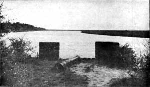
HISTORIC SITES IN THE SOUTH By Roy Edgar Appleman, [Editor's Note: The article below has been adapted from a paper presented by Mr. Appleman before the Southern Historical Association at its meeting last November in New Orleans]. The federal law commonly known as "the Historic Sites Act," which was placed on the statute books August 21, 1935 to provide for preservation of historic sites, buildings, objects and antiquities of national significance, directed the National Park Service to make a general survey to determine which of them "possess exceptional value as commemorating or illustrating the history of the United States." Accordingly, efforts now are being made to place under federal control for perpetual protection those areas that were the scenes of crucial events in our history, for, as Director Arno B. Cammerer pointed out on one occasion, "it is humanly possible, and eminently desirable, to select those sites and objects which will best portray the developing life and characteristics of our nation." The survey has proceeded for the last three years as rapidly as a vailable funds and personnel would permit. More than 100 sites in the South have been listed, classified and made the subject of preliminary reports. Several have been the object of detailed studies and the Service's Advisory Board has approved a few as qualifying for inclusion in the National Park and Monument system. From the beginning of a movement to establish an area as a National Historic Site it generally will be found that the project is initiated by a community group and has the support of local clubs, patriotic societies, historical organizations aid legislative bodies. For the successful preservation of historic sites in the South, as elsewhere, the interest, support and cooperation of federal, state and municipal governments and of various non-profit organizations are therefore indispensable. Some of the fruits of these cooperative undertakings now may be cited. In 1937 Congress enacted legislation authorizing the Cape Hatteras National Seashore. As proposed it includes over 100 miles of the outer sand barrier along the North Carolina Coast, extending from north of Kitty Hawk past Cape Hatteras to the southern tip of Ocracoke Island. Here are situated Kill Devil Hill and the impressive Wright Monument, embraced in a national memorial honoring those famous brothers who in 1903 on this sand waste made the epochal flight that started men's conquest of the air. Easily seen from Kill Devil Hill is Roanoke Island, on which was planted Raleigh's "Lost Colony", the first attempt at English settlement of North America. Here the first child on American soil of English speaking parents began her tragic life, the course of which is still a mystery to us, - reason enough that the site of Fort Raleigh has had an enduring interest for the English speaking world for the last 350 years. Some distance to the south is Cape Hatteras Lighthouse, marking Diamond Shoals, the "Graveyard of the Atlantic." Between the northern and southern tips of this stretch of sand where the turbulent Atlantic meets the American shore are situated many 16th and 17th century Indian village sites, archeologic sites which may hold the key to the story of the "Lost Colony." At Ocracoke Inlet the pirate "Blackbeard" met his death, and some miles to the north, near Nags Head according to tradition, the beauteous and celebrated Theodosia Burr went down to a watery grave in a storm at sea. Between Cape Hatteras and Oregon Inlet there is hardly a mile that does not disclose a hull or some other vestige of ships that were destroyed by the storms that rage over the treacherous shoals along this forbidding coast. What better place on American soil to tell the story of piracy as it concerns American history, or to relate the chronicle of man's struggle with the sea and to pay tribute to the heroism of the United States Coast Guard Service? Interest centers on Roanoke Island and the site of the ill-fated colonists who link American history to the brilliant court of Queen Elizabeth, to the Golden Age of English history, to the period of Drake, Raleigh, Bacon, and Shakespeare. During the last two years Paul Green's remarkably successful pageant play, "The Lost Colony", produced on Roanoke Island, has focused public attention on this site and its story. After several years of effort, and due largely to the splendid cooperation of the Governor of the State, of Congressman Warren, and of the North Carolina Historical Commission, which now administers a restricted state-owned area at Fort Raleigh, the establishment of a National Historic Site here under the administration of the National Park Service seems about to be realized. A few hundred miles to the south along the coast is another memorable historic site. To the present generation it seems almost incomprehensible that a scant 200 years ago newly planted English colonists were contesting with the Spanish from St. Augustine for the control of Georgia. Fort Frederica, built by Governor Oglethorpe in 1736 on St. Simons Island, one of the Golden Isles of Georgia, was the military outpost intended to absorb the shock of hostile incursions against the new colony. It constituted the first line of defense against the Spaniards to the south not only for Georgia, but for the Carolinas and all the rest of the English colonies as well. The scene here is one of mellow antiquity. The waters of the Altamaha River lap lazily at remaining fragments of aged brick and tabby walls. On top the ruins a scarred and half-buried cannon points toward the channel, as if still challenging the approach of an enemy. Large water oaks, heavily draped with Spanish moss, are everywhere in abundance, growing over the site of former guardrooms, the foundations of which are still visible in the ground. The old moat which encircled the fortified area shows plainly. A short distance away, located in a dense thicket of live and water oaks, shrubs, and vines, all covered with a canopy of Spanish moss, is the so-called old Spanish burial ground. Here, raised tombs of brick and tabby and one arched vault mark the site of forgotten dead. Although authorized by Congress in 1936 for federal ownership, vesting of title in the United States still remains to be accomplished.
Inland from the coast and beyond the rolling Piedmont hills is a site known to every American school boy. Dr. Thomas Walker in 1750 gave the name of Cumberland Gap, in honor of the Duke of Cumberland, to a natural opening in the Appalachian mountain barrier beyond which lay the great interior valley. The famous "Warriors Path" led through the Gap, and over it, for generations before the advent of the white man, raiding parties from beyond the Ohio travelled southward, and resolute warriors bent on reprisal traversed it going north. Through this natural gateway to and from Kentucky went noted traders and explorers. After his first trip in 1769 Daniel Boone made many journeys through Cumberland Gap, one of the most memorable being that of 1775 when, with a party of about 30, he blazed a trail from the Watauga settlements on the Holston to the mouth of Otter Greek on the Kentucky River where Boonesborough was founded. Cumberland Gap was a bottle neck through which white civilization passed to Tennessee and Kentucky. It served the historic period of trans-Allegheny expansion. In the summer of 1937 a powerful move was initiated in Kentucky looking toward establishment of a national area at Cumberland Gap. Following an exhaustive study of the project, the National Park Service expressed itself as being in favor of the establishment of a National Historical Park or a National Historic Site, depending on the acreage obtained. Related to the Cumberland Gap project is that for the establishment of Pioneer National Monument. In 1934, the 200th anniversary of the birth of Daniel Boone, Congress passed legislation authorizing the establishment of Pioneer National Monument, naming the sites of Boonesborough, Boone's Station, Bryant's Station, and Blue Licks Battlefield for possible inclusion in the Monument. Boonesborough is one of the most important sites in the United States for commemorating and interpreting our frontier life and history, early westward expansion, and those unnamed but stout and courageous people who constituted "the cutting edge of the frontier." Here was convened the first legislative assembly ever organized west of the Alleghenies, and here was conducted the first religious service in Kentucky. Symbolic of the pioneers and woodsmen who led the way into Kentucky and the great interior valley was the man who gave his name to that early settlement on the Kentucky River. Perhaps the most sympathetic appreciation of Boone was penned by the late Carl Russell Fish who, in an unpublished manuscript, said of him, "without questioning it he loved nature in all its parts, and in his talk, slight as was his vocabulary, he dwelt more on beauty, than on fertility. More permanent a contribution than his guidance of his contemporaries into Kentucky has been Boone's guidance of America's youth to the enjoyment of uncontaminated nature; and to the preservation of its beauty." Far to the south along the lower Mississippi in January, 1815, occurred an event that bequeathed to posterity an important historic site,--- the area at Chalmette where Jackson won his incredible victory over Pakenham's veterans in the Battle of New Orleans. In 1933, by virtue of a Presidential proclamation transferring all historic sites in Federal ownership to the National Park Service, that bureau found on its hands a small area of 18 acres at Chalmette having the status of a National Battlefield Site. It was soon realized that only after an extensive program of land acquisition had been carried out here to include important features and points of historic interest could development of an historical park be undertaken. The Louisiana legislature passed an act directing the State Parks Commission to purchase lands on which the Battle of New Orleans was fought, and appropriated $300,000 for that purpose. The legislation provides that transfer to the National Park Service of title to the lands purchased shall be subject to conditions that will assure the establishment and development of a National Military Park.
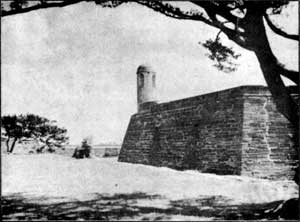
The Chalmette episode is dramatic and unique. No other American scene can show Tennessee and Kentucky frontiersman standing shoulder to shoulder with Frenchmen, Spaniards, Indians, and Negroes in defense of United States territory. Present also were outlaws and pirates, desperate characters from many countries. Strange and arresting names are on the roster of those who were at Chalmette with Jackson. From the Barrataria Bay pirates came such men as their leader, Jean Lafitte; also Dominique You, and Flaujeac, an ex-gunner for Napoleon. A few remains contemporary with Jackson's victory may still be seen at Chalmette; the old LaCoste plantation house, part of the Rodriguez Canal, behind which Jackson formed his line, the ruins of the De la Ronde mansion, built in 1805; and the famous Versailles Allée of Oaks, planted with slave labor by Pierre Denis de la Ronde on his 21st birthday in 1783. Research has disclosed that since 1815 eight hundred feet of Jackson's line at Chalmette has been lost in the river. [Editor's note: A more detailed study of Chalmette and associated sites is contained in Mr. Appleman's "A National Military Park for 'Old Hickory,'" The Regional Review, Vol. I, No. 3, September, 1938]. Within cities, the problems of historical conservation are complex and difficult of solution. This was fully realized by representatives of the Carnegie Institution of Washington, of the National Park Service, and of the City of St. Augustine when they met in the summer of 1936 for the purpose of evolving plans for an historical and archeological survey of St. Augustine. Founded 40 years before Jamestown, this old Spanish post became the first permanent white settlement in what is now the United States. Financed jointly by the Carnegie Institution and the City of St. Augustine, with Dr. John C. Merriam, Director of the Carnegie Institution, serving as temporary chairman of a national committee to determine broad objectives, the survey was launched in November, 1936, under the immediate direction of Verne E. Chatelain, former chief historian of the National Park Service. The Carnegie report, after more than two and a half years of research, now is in the final stages of preparation. The old Spanish coquina-built "Castillo de San Marcos", the oldest masonry fortification in the United States and the most important historic remain in St. Augustine, has been for many years in federal ownership. Since 1933 it has been administered by the National Park Service as Fort Marion National Monument. Closely connected with it in forming the defenses for the old Spanish town were the moat which ran from the fort to the San Sebastian River, the palisades which surmounted the embankment along the moat, and the City Gates. The latter, built of coquina like the fort, still stand. Archeological work and research in old maps have located the moat and discovered the type of construction of the palisades. Because of their connection with Castillo de San Marcos, the reconstruction of these features will most certainly require the close collaboration of the National Park Service, and it is conceivable that the land on which they are situated may be added to the National Monument area. A preliminary report of the Carnegie Institution stated that the success of any plan would depend upon "the willing cooperation of the citizens themselves, upon their ability to see clearly their own future welfare as a part of the related program, and upon their cheerful compliance with certain features of stabilization, preservation, and conservation which must be stressed and which must be respected by local citizens and tourists alike." The State of Louisiana and the City of New Orleans by means of statutes and ordinances have taken steps calculated to preserve for posterity the unique cultural, architectural, and historical qualities of the Vieux Carré in the Crescent City. Recently the federal government was invited by a commission to cooperate with it in formulating a conservation program for the Vieux Carré. This old town, founded in 1717 by Jean Baptiste Le Moyne, Sieur de Bienville, possesses significant historical values and traditions worthy of preservation and perpetuation by our people. At the Cabildo and the Place d'Armes the transfer of the Louisiana Territory to the United States occurred in 1803. Quaint patios and Castilian wrought iron still abound in the "Old Quarter" as reminders of Spanish dominion. The past has given us historic sites, hallowed ground reminiscent of events which survive as great landmarks in the story of our growth as a nation. Let us be motivated in the treatment of these sites by what Carl Becker has described as "a sense of the past." To preserve or to recreate this "sense of the past" in our historic sites is a high ideal; it will impart a cord of continuity from cherished antecedents through our living present to a promising future. | |||
| <<< Previous | > Contents < | Next >>> | ||
|
regional_review/vol2-5c.htm Date: 04-Jul-2002 | ||||