|
| ||||||||||
| Intro | Author | Subject | Volume | Volume/Title | NPS | |||||
|
Volume II - No. 6 |
June, 1939 | |
|
STOLEN WATERS - IN TENNESSEE By Harry S. Ladd, Through his long association with rivers, man has endowed them with many personal traits. To some primitive peoples rivers are gods to be feared, to others they are gods to be worshiped. The Hindus, for example, firmly believe in the healing powers of the filthy Ganges. To the American Negro our Father of Waters is more human than god-like. The Negro speaks of him affectionately as "Ole Man River" yet pleads with him to "stay away from my door!" In point of fact, the analogies are not far fetched for some rivers do have personal traits that ally them with many human beings and some of the lesser gods. Powerful streams are ambitious and single-minded. They wage a ceaseless battle with the land that supports them, trying constantly to reduce it. They even fight among themselves for this privilege. A stream that is more powerful than its neighbor may cut down a divide and divert a portion of the neighboring stream itself. Such a stream is called a pirate and the unfortunate stream that loses a part of its drainage basin is said to have been beheaded. Many cases of stream piracy have been recognized and described for it is well nigh impossible for the pirate stream to obliterate all evidence of the crime. Once of the most famous cases involves the Tennessee River in the vicinity of Chattanooga and it is our purpose to describe this case briefly. We might mention in passing, that the steal took place in early prehistoric times, that no accusation was made until the year 1894 and that the trial (conducted by geologists!) has been going on ever since. Evidence recently uncovered by geologists of the Tennessee Valley Authority leads us to suspect that a verdict of guilty will shortly be brought in.
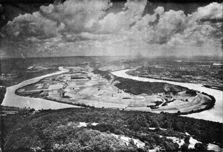
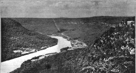
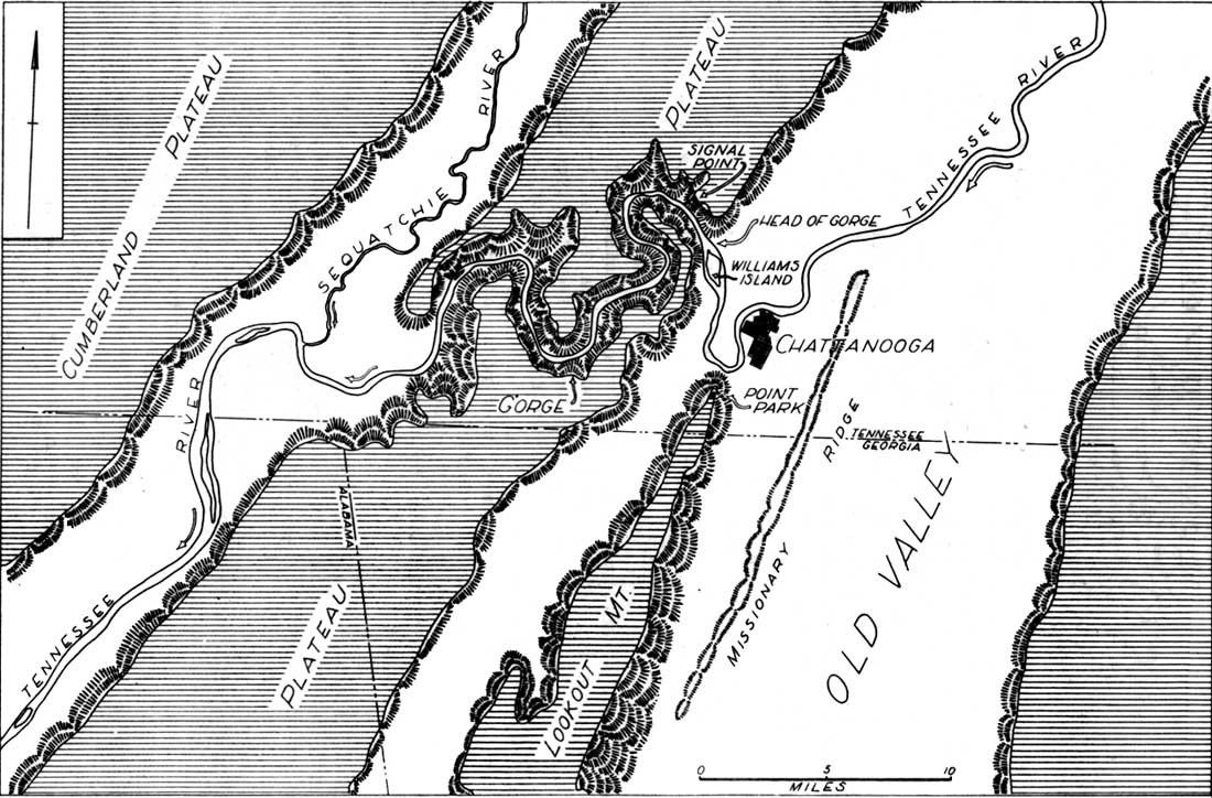
An excellent view of the scene of the crime can be obtained from the northern end of Lookout Mountain, in Chickamauga and Chattanooga National Military Park. Doubtless many thousands of visitors have clicked their shutters with satisfaction as they recorded the view shown on the opposite page. We see the river meandering toward us in broad curves on its wide valley floor until it washes the foot of Lookout Mountain. Beyond the bend in the right foreground lies the City of Chattanooga. Beyond the city, portions of other broad meanders can be seen. In the left side of the photograph the stream takes another broad curve, divides to enclose Williams Island and reaches the head of its gorge. It should be pointed out that this part of the valley is comparatively old. For countless years the stream has shifted its course from side to side, wearing back its valley walls to produce the wide flat. As the river enters its gorge the character of the valley changes completely. It abandons the wide open valley that it has been following southwestward for 75 miles. It makes a right angle turn to enter a comparatively narrow gorge whose walls rise upward for a thousand feet. This, says the prosecution, is an anomalous course. Why, they ask, should the river abandon the wide valley that continues southwestward and is eventually occupied by the Coosa River? Why should it leave the easy grade of the old established valley to enter a youthful gorge cut in solid rock? We shall return to this question in a moment. First let us follow the river itself. For twenty miles the stream twists and turns between its rocky walls (see sketch map opposite), at last reaching Sequatchie valley which, it should be noted, is an open valley similar to the one that the river abandoned near Chattanooga. This second open valley parallels the first and the Tennessee follows it southwestward for 60 miles.
If the significance of the evidence presented is not entirely clear to the jury, it may become so if we proceed to re-enact the crime. There was a time, says the prosecution, when the ancestral Tennessee did not détour through its present gorge. It flowed serenely southwestward to the sea--past Missionary Ridge and Lookout Mountain, to join the stream that we now call the Coosa. Its course was comparatively straight and all parts of its valley were equally well developed. Nearly twenty miles to the northwest the Sequatchie likewise flowed southwestward in an open valley comparable to that of the ancestral Tennessee. (See sketch map) . The Sequatchie, however, flowed along at a somewhat lower level. Between these two parallel streams rose a high, unbroken plateau. The prosecution claims that at an early date a west-flowing tributary to the Sequatchie began to cut a narrow gorge into the high plateau. Slowly it cut its channel downward and extended its headwaters eastward. It is claimed that the power of this stream was increased by a warping of the earth's surface. Finally the tributary cut through the plateau and tapped the waters of the Tennessee. Since its valley offered a quicker escape to a lower level, the Tennessee was diverted to its present tortuous course through the newly made gorge. The old valley south of the point of diversion was left with but a trickle of water flowing southwestward to the Coosa. The early prosecutors built up a strong case against the pirate. They cited other types of evidence in addition to that mentioned above. Many, including writers of conservative geological text books, believed that the pirate was guilty. The lawyers for the defendant, however, dug up new evidence and appealed the case. They built up an alternative explanation that sounded very plausible to many readers. They contended that the gorge and the open valleys above and below it were carved by the streams that now occupy them. Differences in age, they said, are more apparent than real. The gorge is just as old as the open valleys. Its walls are steep and its floor narrow because it is cut in rocks that are harder and more resistant than the rocks of the open valleys. They likewise attacked the other types of evidence offered by the prosecution but all these arguments cannot be reviewed here. They rested their case, having won many supporters, -- having, in fact, successfully hung the jury!
For a long time there were no new developments and it seemed that the case might never again be brought to trial. Finally, however, some important new evidence was uncovered in a wholly unexpected quarter. The TVA began extensive geological explorations in the valley of the Tennessee River. A part of this work consisted in putting down an enormous number of borings, drill-holes and test pits on numerous potential dam sites (1). Some of these sites lay in the open valleys previously referred to -- that of the Sequatchie and that of the Tennessee near Chattanooga. Drill holes in these areas revealed ancient channels and solution levels 100 feet below the present river bed. In connection with the controversy over piracy the discovery of these solution caverns was interesting but not particularly significant until holes had been put down on the site of the Hales Bar Dam in the gorge itself. At this site, though the river is running over the most soluble of all the limestones of the area and though the immediate bed is literally honey-combed by solution, no very deep solution cavities were found. Remembering that underground caverns are formed slowly by solution it would appear that the open valleys above and below the gorge actually are appreciably older than the gorge itself. The distribution of the solution cavities does not offer conclusive proof of piracy but, as Mr. Eckel states (2), it is highly suggestive. It appears to us to be the most damning bit of testimony yet offered against the pirate. (1) All information covering TVA activities is taken with the permission of Edwin C. Eckel, Chief Geologist, TVA, from his mimeographed bulletin, Geological Work of the Tennessee Valley Authority, issued in 1936. (2) Personal communication, 9, 1939. | ||
| <<< Previous | > Contents < | Next >>> | ||
|
regional_review/vol2-6b.htm Date: 04-Jul-2002 | ||||