|
Amistad National Recreation Area Texas |
|
 NPS photo | |
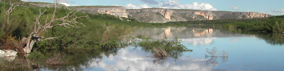
Amistad—"friendship" in Spanish—lies on the United States-Mexico border. The park offers excellent water sports, fishing, birding, canoeing, and bow hunting. The reservoir was created for flood control. water storage, power generation, and recreation in 1969 with the completion of the Amistad Dam. Two bronze eagles at the dam's center symbolize the cooperation between Mexico and the United States in building and managing the dam. The park extends 81 miles up the Rio Grande, 14 miles up the Pecos River, and 25 miles up Devils River.
Amistad National Recreation Area (NRA) protects and interprets exceptional examples of Lower Pecos River rock art, one of the densest concentrations of Archaic rock art in North America. The Panther Cave archeological site, jointly protected by Amistad NRA and Seminole Canyon State Park and Historic Site, is seven miles from Pecos River boat ramp and accessible only by boat. The spectacular Panther Cave pictograph panel is 100 feel long and contains figures 18 feet high. The National Park Service provides a public boat dock and steps that lead to Panther Cave.
Amistad Dam is operated and maintained by the United States and Mexico sections of the International Boundary and Water Commission. The commission transferred ownership of the land on the United States side of Amistad Reservoir to the National Park Service in 1990, when Congress designated the area Amistad National Recreation Area. Today Amistad's mild temperatures make the area a popular winter destination, and good fishing is enjoyed year-round. Welcome to—Bienvenido a—Amistad!
Amistad Reservoir has 540 miles of shoreline in Texas. The Rio Grande is navigable for about 75 miles behind the dam. Boating, waterskiing, fishing, camping, and archeological sites are major attractions. The international boundary follows a line of mid-channel buoys along the historic riverbed. The park offers year-round adventure. You can explore the lake and the Pecos and Devils rivers in motor-boats, sailboats, kayaks, houseboats, and scuba gear. Water temperatures drop to 54°F in winter and rise to 84°F in summer, People enjoy swimming from May to October.
Indian tribes have lived here for thousands of years, hunting, fishing, and gathering other food. Many left their tories in rock art—pictographs—that are some of the oldest in North America. Carbon-dating reveals that some pictographs in Panther Cave are 3,500 years old. Steep limestone cliffs, some over 200 feet high, rise above the Pecos River and the upper Rio Grande arms of the reservoir. Carved by the rivers over millennia, exposed layers tell the region's geologic history. Fossilized shells reveal that this area was once covered by a shallow, inland sea.
Getting To Know the Plants and Animals
Plants Three plant communities meet at Amistad. Honey mesquite and blackbrush of the South Texas Brushlands converge on sotol and lechuguilla of the Chihuahuan Desert to the west. Both merge into the live oak and juniper savannah of the Edwards Plateau to the north. Topography, soil type, and rainfall determine where each community grows best, but they often mingle. Drought-tolerant plants include ceniza, prickly pear cactus, yucca, and ocotillo.
Fish Largemouth, white, and striped bass, crappie, yellow and channel catfish, and alligator gar are popular catches. Texas and/or Mexico fishing licenses are required in their respective waters. Know and obey the regulations.
Other Animals Animals commonly seen here are white-tailed deer, javelina, rock squirrel, black-tailed jackrabbit, ringtail, Texas banded gecko, and nine-banded armadillo.
Poisonous Critters Watch for western diamondback, Mexican black-tailed, and rock rattlesnakes, Trans-Pecos-copperheads, Texas coral snakes, yellow jacket wasps, centipedes, scorpions, and black widow and recluse spiders. Tarantulas are not poisonous but can inflict painful bites. Please be careful. Don't put your hands or feet in places you can't see.
Birds Amistad has excellent habitat for resident and migratory birds. Look for great blue heron, scaled quail, turkey vulture, roadrunner, and an occasional peregrine falcon.
Enjoying Amistad
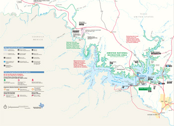 (click for larger map) |
Planning Your Visit
Getting Here Amistad National Recreation Area is west of San Antonio, Texas. Reach it via U.S. 90 or U.S. 277.
Visitor Information Center Here you will find information, exhibits, films, and a bookstore. It is open daily, 8 am to 5 pm, year-round.
The National Park Service oversees facilities, interpretive programs, and protection of cultural and natural resources on the U.S. side of the reservoir.
Fees Boating, camping, and hunting fees apply. Other fees may apply. National Parks and Federal Recreational Lands passes are honored. There is no entrance fee to the park.
Accommodations Food, lodging, gas stations, and RV parks are in Del Rio and along U.S. 90.
Traveling to Mexico If you travel to Mexico you must have a passport to return to the United States. Carrying firearms or ammunition into Mexico is prohibited.
Camping Campgrounds with shelters, tables, and grills are available (no hookups). Only Governors Landing has drinking water. Camp in designated sites only. Camping by boat is allowed except at designated harbors and at boat ramps, developed areas, hunt areas during hunting season, and on private property next to the lake. Commercial campgrounds with full facilities are nearby.
Swimming There are no designated swim beaches in the park. You may swim anywhere except at designated harbors and at boat ramps. Governors Landing picnic area is a popular swimming spot. There are no lifeguards; swim at your own risk.
Waterskiing Waterskiing is allowed from sunrise to sunset only. Along with the boat operator, a competent observer must be aboard. Waterskiing is not allowed at designated harbors and at boat ramps.
Fishing A Texas fishing license is required when fishing in U.S. waters; state regulations apply. A Mexican fishing license is required by everyone in the boat if there is fishing gear on board when you are on the reservoir's Mexican side.
Hunting Archery-only hunting for white-tailed deer, javelina, turkey, and mouflon sheep is allowed in five designated areas. A National Park Service (NPS) hunting permit and Texas hunting license are required; all regulations apply. Hunting with shotgun and birdshot only is allowed in hunt areas for dove, waterfowl, and quail in season.
Private Property Amistad National Recreation Area's boundary is at the 1,144-foot elevation. A high-water mark is visible at about the 1,124-foot level. Please respect the rights of private property owners next to the lake.
Cultural Resources All archeological features, rock art, and artifacts are protected by federal and state laws; laws are strictly enforced.
Source: NPS Brochure (2012)
|
Establishment Amistad National Recreation Area — November 28, 1990 |
For More Information Please Visit The  OFFICIAL NPS WEBSITE |
Documents
A Preliminary Study of the Paleoecology on the Amistad Reservoir Area (Dee Ann Story and Vaughn M. Bryant, Jr., June 1966)
American Indian Tribal Affiliation Study Phase I: Ethnohistoric Literature Review (HTML edition) (Nancy A. Kenmotsu and Mariah F. Wade, ©Texas Department of Transportation, 2002)
Amistad National Recreation Area: Collection Management Plan (Joe Labadie, Paul Rogers, Virginia Salazar-Halfmoon, Martha Simpson Grant and Heather Young, December 2005)
Amistad Recreation Area: Archeological Survey and Cultural Resource Inventory (Phil Dering, 2002)
Binational Fisheries Management Plan for Amistad Reservoir (2006)
Cultural Resources Study: Amistad National Recreation Area (Joe Labadie, October 1994)
Draft General Management Plan/Environmental Assessment: Amistad National Recreation Area (July 2006)
Foundation Document, Amistad National Recreation Area, Texas (August 2017)
Foundation Document Overview, Amistad National Recreation Area, Texas (January 2017)
Junior Ranger Activity Book, Amistad National Recreation Area (Date Unknown; for reference purposes only)
Legacy Data Evaluation Report for Amistad National Recreation Area NPS Natural Resource Report NPS/CHDN/NRR-2011/297 (James Von Loh and Dan Cogan, February 2011)
Master Plan: Amistad National Recreation Area, Texas (Proposed) (February 1969)
Natural Resource Condition Assessment, Amistad National Recreation Area NPS Natural Resource Report NPS/CHDN/NRR-2016/1300 (Patricia Valentine-Darby, Kimberly Struthers, Nina Chambers, Allyson Mathis, Tomye Folts-Zettner, Heidi Sosinski and Robert E. Bennetts, September 2016)
Paleontological Resource Survey, Amistad National Recreation Area NPS Natural Resource Report NPS/NRPC/GRD/NRR-2009/133 (Christy C. Visaggi, Jack G. Johnson, Angel S. Johnson, Jason P. Kenworthy and Vincent L. Santucci, September 2009)
Park Newspaper (The High Bridge Tribune)
Vol. 1 No. 1 — Winter 2003-2004
Picture-writing of Texas Indians (A.T. Jackson, March 1, 1938)
Prehistory in the Lower Pecos: An Overview (Solveig A. Turpin, 1984)
Protecting the National Parks in Texas Through Enforcement of Water Quality Standards: an Exploratory Analysis NPS Technical Report NPS/NRWRD/NRTR-94/18 (Ronald A. Kaiser, Steven E. Alexander and J. Porter Hammitt, November 1994)
Springs, Seeps and Tinajas Monitoring Protocol: Chihuahuan and Sonoran Desert Networks NPS Natural Resource Report NPS/SODN/NRR-2018/1796 (Cheryl McIntyre, Kirsten Gallo, Evan Gwilliam, J. Andrew Hubbard, Julie Christian, Kristen Bonebrake, Greg Goodrum, Megan Podolinsky, Laura Palacios, Benjamin Cooper and Mark Isley, November 2018)
amis/index.htm
Last Updated: 01-Jan-2025