|
Agua Fria National Monument Arizona |
|
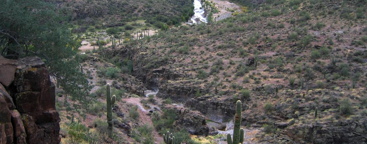 BLM photo | |
The Agua Fria contains one of the most significant systems of prehistoric sites in the American Southwest, including Pueblo La Plata, a major settlement of stone masonry pueblos. In addition to the rich record of human history, the monument contains outstanding biological resources. The area is the home to coyotes, bobcats, antelope, mule deer, javelina, a variety of small mammals and songbirds. Eagles and other raptors are also a draw for birdwatchers. Hiking, viewing cultural sites, wildlife viewing, hunting (big game and upland game birds), scenic drives, and four-wheel driving are among the activities available on the monument. The elevation ranges from 2,000 to 4,000 feet.
A desert grassland extends across an extensive mesa cut by canyon walls and the Agua Fria River.
Source: BLM Website (March 2023)
|
Establishment Agua Fria National Monument — January 11, 2000 |
For More Information Please Visit The  OFFICIAL BLM WEBSITE |
Documents
Access Map, Agua Fria National Monument (BLM, November 2016)
Agua Fria and Bradshaw-Harquahala Draft Resource Management Plan and Environmental Impact Statement (October 2005)
Agua Fria Grasslands Assessment (CEEM XI, August 2006)
Agua Fria National Monument: Record of Decision Approved Resource Management Plan (April 22, 2010)
Annual Manager's Report: 2021, Agua Fria National Monument (Timothy Watkins, Roger Joos, Damon Haan, Timothy Lyons, Chris Gammage and Derrick Yongerman, 2021)
Annual Manager's Report: 2022, Agua Fria National Monument (Timothy Watkins, Roger Joos, Damon Haan, Timothy Lyons, Chris Gammage and Derrick Yongerman, 2022)
Annual Manager's Report: 2023, Agua Fria National Monument (James Holden, Damon Haan, Chris Gammage and Derrick Yongerman, 2023)
From National Register District to National Monument: The Past Ten Years on Perry Mesa (Connie L. Stone, 2006)
Geology, Archaeology, and History Guide to Badger Springs Trail (©R. Kern, R. Heisler, J.J. Golio, Mike Golio, Kim Baines, Wayne Baines and C. Stone, undated)
Hydrologic Characteristics of the Agua Fria National Monument, Central Arizona, Determined from the Reconnaissance Study USGS Scientific Investigations Report 2004-5163 (John B. Fleming, 2005)
Junior Ranger Handbook, Agua Fria National Monument Activity Guide (undated)
Land Status Map (BLM, November 2016)
Manager's Annual Report, FY2014 (Amanda James, 2014)
Manager's Annual Report, FY2011 (Pamela A. Mathis, Sabria Mathis and Vanessa Briceno, 2011)
Map, Agua Fria National Monument (BLM, 2015)
Material Evidence of Immigrant Diversity within the Perry Mesa Tradition, Central Arizona (Will G. Russell and Nanebah Nez, extract from Arizona Anthropologist, Vol. 22, 2012, ©Arizona Anthropologist)
Monitoring of National Conservation Lands: Agua Fria National Monument Case Study (Casey Addy and Paul Sitzsmann, February 2014)
Perry Mesa: A Visitor Guide (Scott Wood, 1999)
Proclamation 7263 — Establishment of the Agua Fria National Monument (William J. Clinton, January 11, 2000)
Reconnaissance Watershed and Hydrologic Analysis on the Upper Agua Fria Watershed (Loyd O. Barnett, Richard H. Hawkins and D. Philip Guertin, undated)
ROD - ARMP: Bradshaw-Harquahala Record of Decision - Approved Resource Management Plan (April 22, 2010)
Science Plan for the Agua Fria National Monument Drat (BLM, July 2009)
Table Mesa Recreation Management Zone, Recreation and Travel Management Plan & Environmental Assessment (June 2010)
Vegetation Community Responses to Juniper Slash/Burn and Broadcast Burn on A Semi-Desert Tobosa Grassland (©Kimberly Sue Cole-Snow, Master's thesis Arizona State University, December 2015)
agua-fria/index.htm
Last Updated: 01-Jan-2025