|
The Pony Express Stations of Utah in Historical Perspective
|

|
THE STATIONS
In the following descriptions, the stations are discussed in the order of their occurrence from east to west. The first name is the one listed in the 1861 mail contract. Other names, local usages, etc. are listed parenthetically.
Needle Rock (The Needles)
Utah No. 1 Contract Station
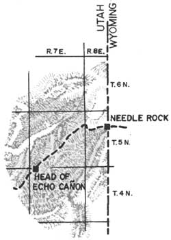 |
Location: NE1/4NW1/4 Section 21, Township 5 North, Range 8 East, Salt Lake Meridian. Eight miles from Bear River Station, Wyoming. Bear River Station is also referred to as Briggs Station, named after the operator. Little information is known about the Needle Rock Station. The 1869 GLO cadastral plat (Figure 4) shows the station location being at Porter's Ranch along the Omaha to Salt Lake Valley Road. The route through this area also was used by the Donner-Reed party in 1846, the Mormon Pioneers in 1847, by General Johnston's Army in 1858, and the transcontinental telegraph in 1861 (See Photo 1). |

|
| Figure 4. 1869 Cadastral Plat - Needle Rock. (click on image for a PDF version) |

|
| Photo 1: The Needles, near the mouth of Coyote Creek. Needle Rock Station was located to the right of the picture. (Courtesy of the Utah State Historical Society). |
Head of Echo Canyon (Castle Rock, Frenchies)
Utah No. 2 Contract Station
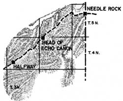 |
Location: Lot 3, Section 6, Township 4 North, Range 7 East, Salt Lake Meridian. Eight miles from Needle Rock Station. This station, the first in Echo Canyon, was named for the large sandstone formation located near the site. The station, made of logs, was sold to a French trapper and moved a mile away in 1867. [15] The station site is located approximately where the old Castle Rock grocery store now stands. (See Photo 2) |

|
| Photo 2: Head of Echo Canyon or Castle Rock Station site (BLM 1978). |
About half way between the Head of Echo Canyon and Halfway Station occurs a geologic feature known historically as Cache Cave, a popular landmark and wayside for travelers (See Photos 3 & 4). The Journal of Captain Albert Tracy mentions, in April of 1860, a station located not far from the cave. The Journal describes the station as a "mere structure of slabs, to keep the wolves off." [16] Possibly this unlocated, intermediate, temporary facility was located at the Squires Ranch, located on the GLO cadastral plat of 1869, and discussed within the field notes (See Figure 5).

|
| Figure 5. 1869 Cadastral Plat - Cache Cave and Squires Ranch. (click on image for a PDF version) |

|
| Photo 3: Historic Cache Cave (BLM photo 1978). |

|
| Photo 4: Historic signatures in Cache Cave (BLM photo 1978). |
Halfway (Daniels, Emery)
Utah No. 3 Contract Station
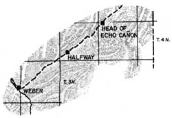 |
Location: NW1/4SW1/4 Section 29, Township 4 North, Range 6 East, Salt Lake Meridian.
Seven miles from Head of Echo Canyon Station.
Unfortunately, Halfway Station remains obscure in history. The 1891 GLO cadastral plat and field notes indicate that the station was operated by a man named Daniels (See Figure 6). The structure was apparently torn down after the railroad went through in 1868.
An unresearched story pertaining to the Echo Canyon region told that in the early months of the Express rustlers working in the area would steal horses from the company exclusively for the purpose of selling them back later. This went on until the horses were marked with the XP (Express) brand.

|
| Figure 6. 1891 Cadastral Plat - Halfway House. (click on image for a PDF version) |
 |
Location: NW1/4NE1/4 Section 25 Township 3 North, Range 4 East, Salt Lake Meridian.
Nine and three-quarters miles from Halfway Station.
James E. Bromley, division superintendent for the run from Pacific Springs Wyoming to Salt Lake City, settled at the mouth of Echo Canyon in 1854. He did not obtain a cash entry patent, however, until June 20, 1874 (Cert. No. 1127). It is reported that the station house, built at the base of Pulpit Rock, had rock walls 26 inches thick. [19] The authors disagree. Located on the Pete Clark property, in Echo, Figure 7, the visible remains of the foundation of the station house have been located and mapped by the authors (See Figure 8). The walls average thickness is much less. The facilities of Weber Station provided the services of a general store, inn, saloon, blacksmith shop and jail. A hotel was built later (See Photos 5 & 6).

|
| Figure 7. Weber USGS Quadrangle Map. (click on image for a PDF version) |

|
| Figure 8. Weber Station |

|
| Photo 5: Weber or Echo Springs. Photo taken in the 1860's. Note telegraph line in the foreground. The station house is on the left (Courtesy of the Utah State Historical Society). |

|
| Photo 6: Weber of Echo Station site today. Station house was located in the large trees (BLM photo 1978). |
Union Pacific purchased the Weber Station and surrounding lands in 1868 and laid out Echo City. Pulpit Rock was destroyed when old U.S. Highway 30 was constructed. [20] The station house, considered unsafe, was torn down in 1931. Five cache pockets containing items of the era were discovered in the walls. [21]
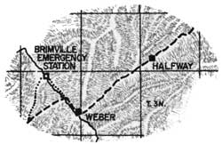
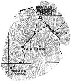
About two miles west of Weber Station, the mail was transported across Forney's Bridge on the Weber River. The bridge was constructed prior to June 1858. [22] From this location, the Express riders traveled up Bachelors Canyon to the top of Dixie Hollow. When the crossing was unsafe or the canyons were snowed in, the rider could go on down the valley to the Brimville Emergency Station or Henneforville (SW1/4SE1/4 Sec. 4, T. 3 N., R. 4 E. now Henefer) (See Figure 9) and around by Little East Canyon to Dixie Hollow. The pioneer immigrants came part way down Dixie Hollow, turned right, crossed the ridge, and then went south into East Canyon. By the time of the Express, the road was built all the way down the hollow to just south of where it opens into East Canyon. The 1858 wagon route map of J. H. Simpson shows East Canyon Creek to be Snyder's Creek. [23]

|
| Figure 9. 1870 Cadastral Plat - Brimwell Emergency Station. (click on image for a PDF version) |
East Canyon (Dixie Hollow, Dixie Creek, Bauchmanns, Snyder's Mill)
Utah No. 5 Contract Station
 |
Location: NE1/4SE1/4 Section 10, Township 2 North, Range 3 East, Salt Lake Meridian.
Ten and one-half miles from Weber via Bachelors Canyon or about 13 and one-half miles from Weber via Henefer.
East Canyon Station, currently inundated by the East Canyon Reservoir, is located in Section 10. Often referred to as Snyder's Mill this error may be derived from information gleaned from Captain Albert Tracy's Journal. It was at Snyder's house, in Section 19, along the road from Parley's Canyon that Tracy stayed the night (From the 1869 GLO survey plat of T. 1 S., R. 4 E., Section 19). Further confusion occurs since Snyder's Settlement (Snyderville) and Snyder's Sawmill are shown as located in Section 31, about 3 miles south of Snyder's House. Samuel Snyder had settled at this location in 1853. [24]
Following its use as a mail station, travelers and sheepherders utilized the area and the neglected buildings (See Photo 7). A sheep corral and grave mark the site, according to the 1881 GLO survey plat (See Figure 10).

|
| Photo 7. The ruins of East Canyon Station with Dixie Hollow in the background (Courtesy of the Utah State Historical Society). |

|
| Figure 10. 1881 Cadastral Plat - East Canyon. (click on image for a PDF version) |
Facing down East Canyon, the Mormons built a fortification about four and one half miles south of East Canyon Station in the SW1/4SW1/4 of Sec. 35. The structure was built for a holding action against Johnston's Army. A site just to the north of here has been called Bauchmanns, but evidently this site is also in error. The pioneers traveled south of Bauchmanns about two and one half miles and turned northwest up Camp Creek or what is now called Little Emigration Canyon. By the time of the Express, a shorter road had been constructed up Monument Creek, or as it is now called, Dutch Hollow. Traces of this road are still visible on the ground.
| <<< Previous | <<< Contents>>> | Next >>> |
ut/2/sec2.htm
Last Updated: 18-Jan-2008