|
LAKE ROOSEVELT The Story of the Columbia Basin Project |

|
HOW IT DEVELOPED
On a hot July day in 1918 in Ephrata, Rufus Woods, publisher of the Wenatchee World, stopped by the Grant County Title & Abstract Co. in search of news. Woods, a newspaperman who believed in personally covering the area served by his paper, was on his regular newsgathering beat. W. Gale Matthews, operator of the title company, passed the time of the day with his visitor and then said, "I'm a little busy right now, but if you want news, I suggest you go over and see Billy Clapp. He can put you on the track of a story which deserves some study and could be the biggest thing you've ever written".
It was only a few steps across the street to the office of William M. Clapp, a local attorney. A few minutes later, Woods was alternately listening and asking questions as Clapp outlined a plan to utilize the Grand Coulee as a waterway to irrigate the land of the Central Columbia Basin. Pointing out that the Grand Coulee had originally been formed when the Columbia River was blocked by a glacier, Clapp suggested that a concrete dam could as effectively block the stream and raise the level of the water to where it could once more be diverted down through Grand Coulee.
The idea was not completely new to the area. People who lived in the vicinity of Grand Coulee had talked about it for years, but the idea had never progressed beyond the stage of discussion. Clapp was probably the first to advance the idea backed by any kind of engineering investigation.

|
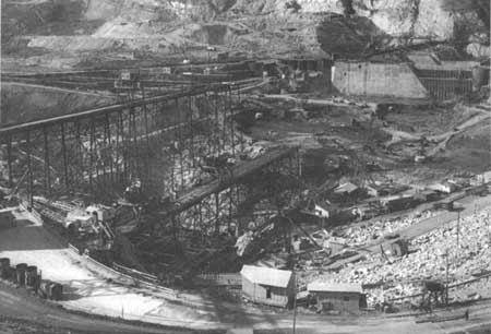
| This is the site of Grand Coulee Dam as it looked before the first contract for its construction was let on July 13, 1934. |
It was first broached to Clapp early in the summer of 1917, when a group of local men were sitting in his office discussing World War I and the talk turned to the production of food. There was a discussion of the potential food value of the basin if water could be put on the land. Someone then suggested that the water for the basin might come from the Columbia River at Grand Coulee. The random remark piqued the men's interest.
In the fall, after several more sessions of talk, Clapp and the others took Norval Enger, a deputy county engineer of Grant County, into their confidence. The group later appeared before the board of county commissioners and asked it to authorize a survey of the proposed area. The commissioners were not enthusiastic about the wild-sounding scheme but consented to a survey provided nothing was said publicly about it.
Enger looked over the general situation during the winter of 1917-18 and ran a set of levels on the river and the coulee. He reported to the commissioners, and to the group requesting the survey, that the plan seemed to have merit but would require a great deal more study. He admitted that the total costs of such a project would certainly be far beyond the financial resources of the county—but the project appeared to be feasible.
|
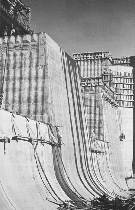
| This is the dam as it looked in late 1936 from the river's east bank. Trestles in the left foreground mark the present line of the dam. The area is enclosed by a cofferdam and the river is flowing through the partially completed section of the dam in the upper right of the picture. |
On July 18, 1918, the Wenatchee World published the story as outlined by Clapp and written by Woods. It was headlined:
FORMULATE BRAND NEW IDEA FOR IRRIGATION GRANT, ADAMS, FRANKLIN COUNTIES, COVERING MILLION ACRES OR MORE
Last and Newest and Most Ambitious Idea Contemplates Turning of Columbia River Back into Its Old Bed in Grand Coulee, the Development of a Power Plant Equal to Niagara and the Construction of the Greatest Irrigation Project in the World—First Conceived by William Clapp of Ephrata, Wash.
A few months after the Wenatchee World printed the story of Billy Clapp's proposal to irrigate the Columbia Basin by building a dam across the Columbia River, a radically different plan to achieve the same purpose was proposed by the chairman of the State Public Service Commission, E. F. Blaine.
Blaine had lived in the Yakima Valley for years and was familiar with irrigation. His plan was to transport water to the basin in a gravity-waterway system from Pend Oreille Lake in Idaho, a distance of about 130 miles. He proposed a dam be built across the Pend Oreille River in the vicinity of Albeni Falls in Idaho, near Newport, Wash. The main waterway was to be a succession of canals, natural waterways, viaducts, and siphons terminating in a reservoir near Ritzville, just outside the eastern edge of the present project area. From this reservoir, the water was to be distributed to the basin lands.
Both proposals for irrigating the basin lands had their own group of backers. But, in addition to the opposition each plan found in the adherents of the other group, there was opposition from others who feared that the cultivation of the basin land would wreck the price structure of farm products and others who opposed both plans because of their high cost.
In 1919, the Washington Legislature created the Columbia Basin Commission and appropriated $100,000 to be used in making a study of the two irrigation plans. The report issued by the commission favored the gravity waterway method.
In 1921, however, a Seattle engineer, Willis T. Batcheller, released a report favoring a dam at Grand Coulee after making a study of both proposals. Then Maj. Gen. George W. Goethals, who had built the Panama Canal, was retained by the Columbia Basin Commission to make a study of the situation. After studying the basin and maps and reports on both plans, the general submitted a report March 30, 1922, favoring the gravity method, saying it would be simpler and cheaper to build. First the one plan and then the other momentarily appeared triumphant.

|
| Grand Coulee Dam as seen from Crown Point. The city of Coulee Dam appears in the right foreground. |
James O'Sullivan, a native of Port Huron, Mich., was one of the chief figures in this seesaw battle who spearheaded the fight to build the dam at Grand Coulee. O'Sullivan came to the basin to buy an irrigated farm on the shores of Moses Lake and remained to practice law instead. In addition to being a lawyer, O'Sullivan had been a contractor in Port Huron, where he operated the family's construction business for several years. His personal investigation of the site of the proposed dam and his knowledge of engineering convinced him the dam was feasible, and he spent all his time and efforts in pushing the Grand Coulee plan, working without pay and forsaking his law practice. For O'Sullivan, the fight for Grand Coulee became a way of life.
The turning point in the struggle came through the bipartisan efforts of two Washington State Senators, Republican Wesley L. Jones and Democrat Clarence C. Dill. Together, they tried to secure an appropriation of $600,000 during the 1926 session for a comprehensive study of the two different schemes of irrigation, but they were unable to get the support of Congress. However, Senator Jones, a senior member of the Commerce and Appropriations Committee, inserted the appropriation in a rivers and harbors bill where it was undetected by the opposition. The appropriation called for a study of the Columbia River, but mentioned neither Grand Coulee Dam nor the gravity plan.
The measure passed and Maj. John S. Butler of the Army Engineers was directed to make the survey. The work started in 1928 and was completed in 1931 at a cost of $316,441. In his report to the House Committee on Irrigation and Reclamation, Major Butler said, in part, " The gravity plan is not economically feasible because of excessive costs.... The pumping plan of placing water on the project is altogether feasible, both from an economic and an engineering viewpoint . . . ."
Proponents of the dam, led by O'Sullivan, began working for the dam all the harder. In fact, the residents in and around the town of Ephrata worked so hard and became so conversant about various aspects of the proposed project that the whole community was labeled "the dam university." Major opposition developed from private utilities, who proposed a low-head power dam at the Kettle Falls site.
In an ironic way Mother Nature even lent a helping hand. During the winter of 1929-30 the Pacific Northwest experienced a crippling power shortage as a result of a drought that robbed the comparatively small streams of the Puget Sound of their power. The "dam university" was not slow in pointing out that the source of the proposed Grand Coulee Dam's power was the Canadian icefields, impervious to drought.
In April 1931, passengers aboard an ocean liner 600 miles off the coast of Seattle heading for Honolulu were suddenly engulfed in a huge cloud of fine dust. The cloud was estimated to extend from about 300 miles east of Portland to 1,000 miles out to sea. This was the topsoil of the Pacific Northwest. The best way to stop this mass exodus of sorely needed land? Irrigation—irrigation such as the Grand Coulee Dam could provide to feed the millions of grasping roots which would hold the land down.
But Congress still had little stomach for this expensive irrigation project in the remote Northwest. The country was engulfed in what appeared to be a bottomless depression. In a special message to Congress in February of 1932, President Hoover said: "We do not need further additions to our agricultural lands at present. Additional agricultural production, except such marginal expansion as present projects warrant, is inadvisable."
One year later, however, a presidential candidate by the name of Franklin D. Roosevelt outlined to newsmen a bold plan to strike at the heart of another serious problem facing the Nation, unemployment. The plan called for a broad development program of the Nation's resources with the primary purpose of providing jobs. True to the precampaign speeches, a few weeks after election President Roosevelt included Grand Coulee Dam in his new Public Works Administration Program.
The State of Washington allotted $377,000 for preliminary work at the damsite and the job of building a dam at Grand Coulee was handed to the Bureau of Reclamation. The late Frank A. Banks, who had headed dam construction on several other Reclamation projects, was named construction engineer in charge of the work. Temporary quarters for a skeleton force of engineers was set up at Almira until a town could be built at the damsite.

|
| With the dam completed, work began in earnest on the many miles of waterways needed to transport the water to the land. |
On September 9, 1933, Frank Banks, Clarence Cole, Althe Thomas, Fred Berry, Ceylon Rossman, and Harold Sheerer drove the stakes for the axis of the dam. A few months later, clearing of the site and removal of soil and gravel deposits to reach foundation rock got underway.
When the Grand Coulee Dam was first proposed, investigations established the height of the dam at about 350 feet above river level. This was high enough to allow pumping of water for irrigation and was low enough to prevent backing water into Canada. During the 15 years from the first proposal of the idea to the start of construction, the concept of a high dam capable of providing irrigation water was never abandoned. However, when President Roosevelt gave his approval to the idea of a dam at Grand Coulee, in order to save money he suggested building a low dam at a cost of about $63 million with the possibility of adding more height to the dam later.
Backers of the irrigation plan were bitterly disappointed. A low dam would be capable of generating electricity, but the basin still would have no water. On July 13, 1934, the contract to build the low dam was awarded to the MWAK Co. for $29,339,301. MWAK was a merger of several different firms, the principal companies of which were the Silas Mason Construction Co., the Walsh Construction Co., and the Atkinson-Kier Co. Building even the low dam at Grand Coulee was too big a job for any one contractor.
Four days after this contract was awarded, a contract was awarded to David K. Ryan to build 32 miles of railroad to the damsite from a connection with the Northern Pacific line near Coulee City. The line ran from Odair to the damsite at the bottom of what is now Banks Lake and was operated by the contractors to haul materials and equipment. The line was built in a year. During this same period, the State highway department spent more than $600,000 on roads and bridges in the general area of the dam.
Almost a year after the contract for the low dam was let, the backers of Grand Coulee Dam had reason to celebrate. A change order was approved allowing construction of the high dam. In January 1938, MWAK finished its contract and, less than a month later, Consolidated Builders, Inc., a joint venture formed by MWAK and several other construction companies, was given a contract to finish the high dam for a bid of $34,442,240.
The dam was built in steps, with the flow of the river being juggled back and forth in its channel as work progressed. The first section of the dam was built on the west river bank, while a cofferdam diverted the river and channeled the water along the east bank. This cofferdam enclosed about 60 acres, which was excavated to bedrock and then cleaned and grouted to make a firm foundation for the dam. Concrete was then poured in the area until it was above low water level. After the west portion had been built up, the cofferdam was opened to allow the water to pass through on that side. Across the river, cofferdams on the east side were closed and the operation was repeated.
Then the workmen ran into a problem—wet clay on the east bank slipped down faster than it could be removed. After retaining walls and several other plans had failed to stop the sliding mass, one of the younger engineers suggested freezing the problem area. A refrigeration plant was built and miles of ammonia pipes were buried in the toe of the slide. The ice dam held back the clay and the work continued. On May 25, 1939, a world's record was set when 41,900 tons of concrete were poured in 24 hours onto the growing gigantic mass that was to be Grand Coulee Dam.
Although Grand Coulee Dam is now a solid mass of concrete, it was built as a group of interlocking columns, varying in size from 50 feet square to 25 by 44 feet. These columns were built up 5 feet at a time, with 72-hour intervals between pourings. Because concrete shrinks as it cools, the joints between these columns could not be filled with grout or liquid concrete to make the dam solid until the temperature of the individual columns had cooled. Engineers estimated it would take several hundred years to cool the concrete at the normal rate, so pipes were embedded in the concrete as it was poured and river water was pumped through them to cool the structure. The concrete cooled in a matter of months and the joints and pipes were then filled with grout. About 1,700 miles of this pipe is buried in the dam today.
As Grand Coulee Dam neared completion, World War II erupted. The United States was soon frantically building weapons for its own defense and for countries soon to be its allies. The demand for power outstripped all available supply and Grand Coulee Dam became the center of attention as a potential source of electrical power.
On March 22, 1941, the dam's two small station service generators were put into operation. Even these units could not operate at full capacity, however, because there was not enough water behind the dam, but they put out as much as possible—about 14,000 horsepower, or nearly 11,000 kilowatts. On October 4, 1941, the first of the 108,000-kilowatt generators was put into service. Five more generators were rushed to completion, and two more, scheduled to be installed in Shasta Dam in California, were shifted temporarily to Grand Coulee. This immense amount of available power later made the Hanford atomic installation possible at Richland, which proved to be a great factor in the manufacture of atomic products and helped bring an end to World War II.
The demand for power continued after the war as Northwest industry expanded. The last of the dam's 18 generators went into service September 14, 1951. This made the powerplant of Grand Coulee the largest in the Western Hemisphere, a position it still holds, with an installed capacity of 1,974,000 kilowatts. However, the actual output is quite often greater than that. The plant has an hourly output record of 2,324,000 kilowatts (September 9, 1953, 9-10 a.m.).
After the war, the emphasis at the dam shifted from power production to its primary purpose, the irrigation of land. Work began on the pumping plant at Grand Coulee and contractors were soon building tunnels, siphons, storage dams, and canals throughout the Columbia Basin Project area. The land was classified and appraised, the soil tested, and the whole area was laid out in farms and irrigation blocks. More than 4,000 topographic maps were drawn, one for each square mile of land, and the force handling land classification took 45,000 soil borings and performed more than 15,000 soil analyses and tests. The land classification was finished in August 1941.
Now the project area was divided into irrigable and nonirrigable lands. Land suitable for irrigation was divided into three classes, according to how well it would produce under irrigation. Class 1 land was the best. It was smooth, gently sloping, deep and fertile soil, adaptable to a wide range of crops and free of alkali and rocks. Class 2 was average land, good for farming, but not as good as Class 1. Class 3 included land which could be farmed by irrigation, but was restricted in the kind of crops it would grow and was expected to give poorer yields than the other lands.
After the land had been tested and classified, it was appraised. The value of the land was determined by a board of three men well versed in land values in the basin. The land value was based on how much the land was worth as a dryland farm.
Finally the land was ready. All that was needed was the completion of the main system of waterways to bring the final important ingredient, irrigation water. On August 10, 1951, the first test water flowed into the main canal from Banks Lake toward the waiting Columbia Basin farmland.

|
| In conclusion—a county fair with a display of basin crops. |
The subsequent development of project lands was a slow, steady process with water coming to more of the land each year. This gradual development made it easier for the area and the irrigation system to accommodate more farms and for markets to absorb the increased production. This gradual development and growth of the project is still continuing.
The Columbia Basin Project was planned as a family-type development, designed to provide a farm which would yield a living for one family. Under the original project law, ownership by any one family was limited to one farm unit, or a maximum of 160 acres of irrigable land. As amended in 1957, the law allowed, each adult in the family to own and receive water for up to 160 acres of irrigable land. However, a new amendment, enacted on October 1, 1962, entitles all landowners to water for 160 irrigable acres or 320 irrigable acres for a husband and wife regardless of when the land was acquired.
The average farm unit on the project is presently about 85 irrigable acres, depending on the quality of the land. Those farms with the better land are smaller than those with poorer land. In this way each farm's potential income is adequate to support a suitable standard of living.
The purchaser of a Reclamation farm unit signs a recordable contract in which he agrees to pay part of the construction costs of the irrigation system. Payments are based on the project farmers' ability to pay. The average repayment of $85 per acre was established in the original repayment contracts on October 9, 1945. Construction costs were to be repaid over a 40-year period and averaged $2.12 an acre per year.
In 1962 and early 1963 the farmers in the three irrigation districts which the water users of the project had formed voted to accept a revised repayment contract negotiated with the Bureau of Reclamation which increased the repayment costs to an average of $131.60 per acre, and lengthened the repayment period to 50 years. The new repayment contract will permit all of the project drainage construction costs to be included in the construction repayment arrangement instead of being paid separately each year while the drains are being built.
Under the revised repayment contract with the project's three irrigation districts, the construction charges per acre will be rather small during the early years following the development period, and gradually increase in succeeding years in such a manner that full repayment will be accomplished in 50 years. Water rental charges, which pay operation and maintenance expenses of the water delivery system, are also based upon the repayment ability of the various classes of land on the project.
Under the new amended repayment contract, the first water users in the Columbia Basin Project will repay their construction charges by the year 2010, almost a century after the idea for the project was conceived. But the costs of the Columbia Basin Project cannot be tallied entirely in terms of money. For many who stood and watched the first trickle of water flow to the south from Banks Lake in 1951 could remember the early days when they fought what seemed to be an almost hopeless battle. Perhaps they thought of the disappointments and the bitterness, of the small battles won, and of the constant and exacting hard work required to win this victory.
Regardless of the yardstick used to measure and appraise it, the project has already proved itself more than worth all costs of all kinds. Where nature had decreed a desert, man has made a prosperous land complete with power, water, and people.
| <<< Previous | <<< Contents>>> | Next >>> |
columbia_basin/sec8.htm
Last Updated: 01-Feb-2008