|
LAKE ROOSEVELT The Grand Coulee Dam and the Columbia Basin Reclamation Project |

|
Section I.
THE GRAND COULEE DAM (continued)
THE COLUMBIA RIVER STORAGE BASIN
SIZE AND CAPACITY
A storage reservoir 151 miles long, averaging 4,000 feet in width and with a maximum depth of about 375 feet, will be formed behind the dam. It will extend up the Columbia River to the Canadian border, the elevation of which determined the height of the dam, and up the Spokane River 32 miles.
The reservoir will have an area of 82,000 acres (128 square miles), and a total capacity of about 10 million acre-feet of water—equivalent to 25,000 gallons for every inhabitant of the United States, nearly a 10-year supply for all purposes for the city of New York. The estimated annual evaporation from the reservoir will be 200,000 acre-feet.
The overage annual rate of flow of the Columbia River would fill the reservoir in about 2 months, and the average flow in June or July would fill it in less than 1 month.
USEFUL STORAGE CAPACITY
The upper 80 feet of the reservoir capacity, something over 5 million acre-feet, will be utilized when necessary for power production and for the regulation of the river flow for the benefit of future downstream power plants, and for the improvement of navigation. Since the high-water and irrigating seasons coincide, stored water will not be required for irrigation, nor for power in pumping irrigation water.
|
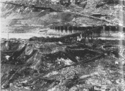
| Thirteen million yards of overburden were carried away from dam-site excavations by this system of belt conveyors |
SILT
The streams tributary to the Columbia are almost always clear and free from silt. Solid matter causing slight turbidity during part at the flood season is extremely fine, and practically all of it is carried in permanent suspension. Silt will have no detrimental effect on the utility of the reservoir.
LANDS ON THE RESERVOIR SITE
The high-water line in the reservoir will be 1,292 feet above sea level. All lands in the river basin upstream from the dam and below elevation 1,310 have been reserved for reservoir purposes. The greater part of such lands are privately owned. They have been surveyed and appraised and will be acquired by the Government. Chiefly cut-over timber lands, grazing lands, and pasture lands are affected. Two small towns and a little cultivated load are included within the reservoir area. Several miles of highway and railroad will be relocated, and several new bridges will be built to accommodate them.
Kettle Falls and the nearby points at which fur-trading posts were established more than 100 years ago will be inundated.
| <<< Previous | <<< Contents>>> | Next >>> |
grand_coulee_dam/sec1b.htm
Last Updated: 01-Feb-2008