|
Captain John Smith Chesapeake National Historic Trail VA-MD-DE-DC-PA-NY |
|
 NPS photo | |
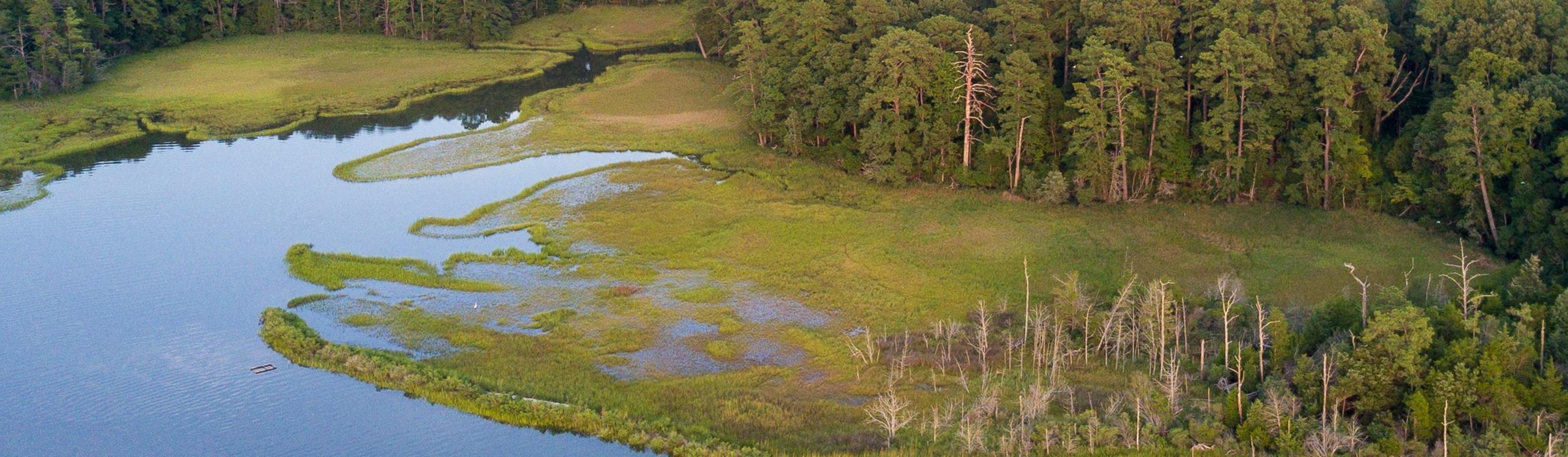
Some journeys make good stories. Some make a mark on history. The travels of John Smith, who captained a small wooden boat across the Chesapeake Bay in the early 1600s, did both.
Smith and his crew sailed from a struggling English outpost into a world they knew little about. They had no maps to guide them. They traveled an enormous web of waterways, where forests were as vast as the marsh. And it was not vacant terrain. The American Indians who already lived along the shoreline met Smith at nearly every turn.
Based on these travels, Smith created a detailed map of the Chesapeake Bay region. He also kept records of his voyages and later published his accounts. His map and writings influenced the exploration and settlement of eastern North America for many generations. Although scholars sometimes dispute their accuracy, they also provide a remarkable, firsthand record of the Chesapeake region before English colonies controlled it.
Today, you can follow Smith's travels on the Captain John Smith Chesapeake National Historic Trail, learn the traditions of descendant American Indian tribes who still live here, and experience the richness of the Chesapeake and its rivers. By land and by water, you'll make discoveries of your own.
American Indians
Native people occupied the shores of the Chesapeake Bay and its rivers for thousands of years before Europeans arrived. The people were living in towns and dispersed settlements on both sides of the Bay when the Virginia colonists set up James Fort in 1607. Smith identified more than 200 native communities on his map, although many more existed than Smith encountered.
The region included Indian groups of different sizes, each with their own identities. Some of these groups also paid tribute to a powerful leader, known as Powhatan, who lived at Werowocomoco on what is now the York River in Virginia.
John Smith and Jamestown
John Smith arrived on the shores of the Chesapeake Bay in 1607, along with three ships carrying English colonists. It was a business venture, run by the Virginia Company of London, which instructed the men to find gold and a westward passage to the Pacific Ocean.
The colonists built a fort on what is now the James River in Virginia, on the Bay's western shore. This outpost later became Jamestown, the first capital of Virginia. Smith was one of the fort's leaders and helped see the men through difficult times. His efforts in building relationships with the Indians were essential to the survival of the colony.
Voyages and Explorations
Smith began exploring the Chesapeake Bay and rivers near James Fort as soon as he arrived in 1607. He traveled many of the Bay's tributaries before embarking on two major voyages during the summer of 1608. His expedition ranged from the James River in Virginia, to portions of the Chesapeake's Eastern Shore, the Great Falls on the Potomac River, and the mouth of the Susquehanna River near present-day Havre de Grace, Maryland.
Both voyages lasted about two months and took place in a small open boat, equipped with one sail and oars for paddling. Fifteen men traveled on the first voyage, between June 2 and July 21. They sailed and rowed up the Eastern Shore as far as the Nanticoke River, crossed the Bay near Calvert Cliffs, and explored the Patapsco and Potomac rivers.
After a short stop at James Fort, Smith launched the boat again, with thirteen men on board. Between July 24 and September 7, they explored the Rappahannock, Patuxent, and Susquehanna rivers.
In all, Smith documented nearly 3,000 miles of the Bay and its rivers, as well the location of Indian communities, with remarkable precision.
Adventures and Encounters
During his voyages, Smith visited many Indian communities on both shores of the Bay and near the mouth of the Susquehanna River. Some approached with caution or hostility, but Smith generally restrained his men and the tension of first encounters often shifted into trade and feasting. He received valuable help from Indian guides and interpreters. A Wiccocomico man named Mosco traveled with them during parts of both voyages.
Smith made note of many places known today, including Calvert Cliffs—which he called "Rickards Cliffs"—and the great marsh of Tangier Sound. When a storm blew away their sail, the men took shelter on Bloodsworth Island, which Smith dubbed "Limbo Isle," to repair the boat and search for drinking water.
The simple wooden boat that carried Smith and his crew had both oars and a sail. It was ideal for moving through shallow waters, but it was also an open boat, exposing the men to heat and storms. At times the waters they traveled were teeming with fish. Smith reported "fish lying so thick with their heads above the water as for want of nets (our barge driving amongst them) we attempted to catch them with a frying pan." The crew struggled in the summer heat, and many men fell ill. One man, Richard Featherstone, died along the Rappahannock River. His funeral took place at a site that Smith called Featherstone Bay.
Smith himself was seriously injured during the first voyage. While he fished in the shallows near the Rappahannock River, the tail of a cownose ray pierced his wrist. He had a severe reaction to the venom, and the crew feared for his life. Later, when Smith recovered, he ate the ray for dinner and named the site Stingray Point.
Plan Your Adventure
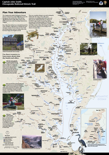 (click for larger map) |
The Captain John Smith Chesapeake National Historic Trail travels nearly 3,000 miles across the Chesapeake Bay and its rivers. The trail was officially launched in May 2007, as part of the 400th anniversary of the founding of Jamestown, Virginia.
Since then, the trail has been extended beyond the route of Smith's explorations to include the rivers and upper reaches of rivers that served as trade and transportation routes for Indian tribes who lived here before the English arrived.
There are countless things to see and do along the Smith trail. The water routes offer great experiences for paddling and power boats, and there are lots of land-based sites to visit by car. You'll find opportunities for boating, hiking, bicycling, and watching wildlife, as well as historic settings with museums, living history exhibits, and visitor centers. Many sites along the trail offer several of these options in one setting or in a cluster of nearby sites.
Use these resources to learn more about what the Smith trail offers.
Visit the trail website at www.SmithTrail.net
Check out the map or use the "Adventure Planner" to design your
itinerary. Explore your options on a variety of water trails, and read
excerpts from the official boater's guide. This website also offers lots
of information about Smith, American Indians (past and present), and the
Chesapeake Bay of the early 1600s.
Visit www.FindYourChesapeake.com
to inspire your next adventure along the Smith trail and throughout the
Chesapeake region. Read travel articles for trip ideas, enjoy stunning
photography, and search for specific interests—like boating,
camping, geocaching, maritime heritage, and more—in the places you
would like to visit.
Call Up a "smart buoy."
These yellow buoys float on the water to mark places on the John Smith
trail. They also transmit recordings about that location 400 years ago.
You can access buoy information at www.buoybay.noaa.gov
and by phone toll free at 877-BUOY-BAY.
Source: NPS Brochure (c2015)
|
Establishment Captain John Smith Chesapeake National Historic Trail — December 19, 2006 |
For More Information Please Visit The  OFFICIAL NPS WEBSITE |
Documents
Common Interpretive Strategy for the Religious Freedom National Scenic Byway, Potomac Heritage National Scenic Trail, Captain John Smith Chesapeake National Historic Trail and Star-Spangled Banner National Historic Trail, Charles and St. Mary's Counties, Maryland (Heritage Strategies, October 2014)
Feasibility Study Environmental Assessment, Captain John Smith Chesapeake National Historic Water Trail (July 2006)
Final Comprehensive Management Plan and Environmental Assessment, Captain John Smith Chesapeake National Historic Water Trail (February 2011)
Junior Ranger Activity Book (Ages 6-12), Captain John Smith Chesapeake National Historic Trail (2017; for reference purposes only)
Statement of National Significance, Captain John Smith Chesapeake National Historic Water Trail (John S. Salmon, c2006)
cajo/index.htm
Last Updated: 01-Jan-2025