|
Canaveral National Seashore Florida |
|
 NPS photo | |
Sheltering Spaces
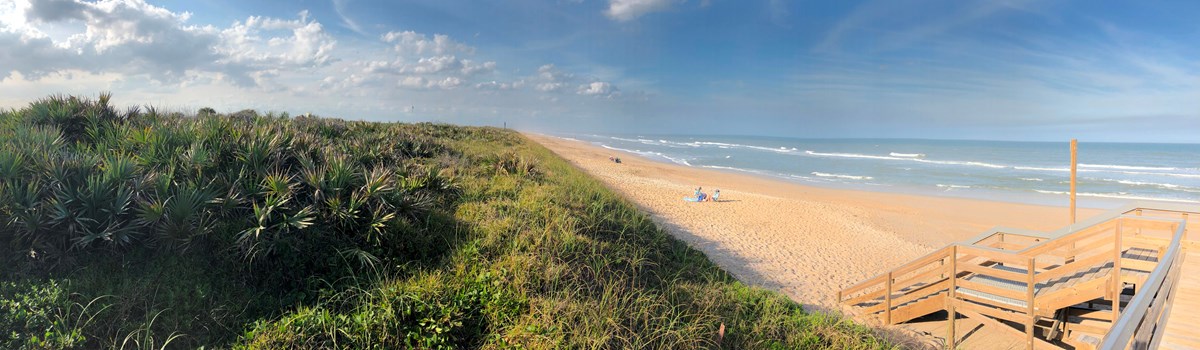
Neither buildings nor seawalls disturb this wilderness beach on Florida's east coast. At both the national seashore and wildlife refuge, nature lives in harmony with human technology.
Don't be surprised if you see a red-tailed hawk or a bald eagle keeping watch over land and water.
From isolated beaches and inland channels to life-filled marshes and lagoons, water takes command here.
Guided by instinct, loggerhead sea turtles struggle onto the protected beach to deposit eggs into nest cavities dug with their flippers.
Preserving Species
For many plants and animals found here, living at this national seashore and wildlife refuge means more than life as usual—it means life over extinction.
Mention Canaveral and Merritt Island and many people imagine space exploration—the exciting countdown, the thrilling liftoff. But another quality of space here is almost a secret from outsiders. This space can be secluded as gentle breezes caress miles of primitive beach or endangered sea turtles struggle from their leathery eggs. This space can also be boisterous, as tropical blossoms' aromas waft on humid air—and insects noisily approve.
This space has been preserved through the teamwork of three federal agencies. In the 1950s it was set aside to buffer activities of the nearby National Aeronautics and Space Administration (NASA). The space race gave the John F. Kennedy Space Center world prominence and ensured preservation of this barrier island. Working with NASA, the US Fish and Wildlife Service has managed Merritt Island National Wildlife Refuge since 1963, and the National Park Service has run Canaveral National Seashore since 1975. These agencies care for this special area, where warm waters and a temperate climate nourish species as diverse as bald eagles and alligators or bromeliads and mangroves.
Winds and Atlantic waters massage the beach's sand grains into dunes that parallel the shore as far as you can see. Hidden in this graceful image is the buttress of a barrier island—a low-lying ribbon of land braced with a spine of sand dunes. Behind this protective island, salty Atlantic water flowing through inlets combines with seasonal rains to form the Indian River and Mosquito Lagoon estuaries. Fish, oysters, clams, and shrimp begin life in these fertile nurseries, which, in turn, attract an abundance of waterfowl. Until the late 1950s the marshes also nurtured saltmarsh mosquitoes, which at times could produce a million mosquitoes per square yard in one day. Because saltmarsh mosquitoes don't lay eggs in fresh water, engineers divided 69,000 acres of marsh into walled impoundments to control water levels, salinity, and mosquitoes. The new environment attracted new residents, and today it is common to see waterfowl, alligators, otters, and wading birds, like snowy egrets, white ibises, and great blue herons.
The barrier island and its waters offer sanctuary for an abundant mix of plants and animals. Recorded here are 1,045 plant species and 310 bird species. Hammocks of ancient oaks draped with Spanish moss grow near sand dunes covered with palmetto and sea oats. Thousands of migratory birds stop over on their journeys north and south. Fourteen wildlife species federally listed as endangered or threatened include sea turtles. West Indian manatees, southern bald eagles, wood storks, peregrine falcons, eastern indigo snakes, and Florida scrub jays. Canaveral and Merritt Island form a sheltered space, where the countdown is not of spaceships but of endangered animals ensuring life for future generations.
Inviting Spaces
You may not see anyone else, but you will not be alone. Come share the warm sand with shorebirds and watch for other wildlife and flowers along quiet trails.
Canaveral, this "place of canes" named by Spanish explorers, bears one of North America's oldest recorded place names. Surveyor Pedro Marratt probably named Merritt Island, charting it in the early 1800s. But human imprints were here long before European explorers put ashore. American Indians, attracted by fertile estuaries and the temperate climate, harvested oysters and clams, discarding shells in heaps—middens or mounds—that archeologists study, like those at Seminole Rest, Turtle Mound, and Castle Windy. In April 1513 Ponce de Leon's sailors claimed the land for Spain, and in 1763 the British took control of Florida's east coast. But vast wetlands, clashes with Seminole Indians, and clouds of saltmarsh mosquitoes delayed development until Douglas Dummett planted an orange grove in 1830, launching the Indian River citrus industry.
For the next century villages near citrus groves or water passages took hold briefly, then fell to storms, isolation, or killing frosts. Eldora was a late-1800s town near Mosquito Lagoon. A lone house, Eldora State House, survives and is open to the public. Seminole Rest, where Timucuan Indians probably gathered and shelled clams, dates from 4,000 to 500 years ago. It's now 18 feet high. Early 1900s settlers who refused to sell its contents for road building thereby preserved its clues about Timucuan life. Exhibit panels along a half-mile trail there convey more history of the mound.
Today this inviting space is yours to enjoy. Relax on a deserted beach or hike in forests of Spanish moss-draped live oaks. Scout, by boat, sail, or canoe, Indian River or explore Mosquito Lagoon for oysters, clams, pink shrimp, or blue crabs. And don't miss Black Point Wildlife Drive. Its six-miles can take an hour or all day, depending on how many stops you make to view wildlife. Whether you seek solace or adventure, the national seashore and the wildlife refuge welcome you.
Enjoy the National Seashore and Wildlife Refuge
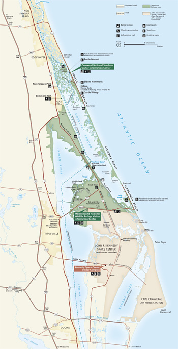 (click for larger map) |
Directions and Visitor Centers The national seashore and wildlife refuge are reached via US 1, I-95, and FL 528, Beachline Expressway. Northern access: New Smyrna Beach is on FL A1A. Seminole Rest is east of US 1 in Oak Hill on River Road. Southern access: Titusville is on FL 406/402. Playalinda Beach is reached via FL 402. The Seashore has a daily entry fee and honors the Recreational Lands Pass series. The Seashore visitor center, seven miles south of New Smyrna Beach on FL A1A, offers exhibits, schedules, publications, and an orientation program. The Refuge visitor center, four miles east of Titusville on FL 402, offers exhibits, publications, and information.
Accessibility We strive to make our facilities, services, and programs accessible to all. For information go to a visitor center, ask a ranger, or check the "dot gov" websites.
Beaches The Seashore has undeveloped beaches and limited services: no picnic facilities, phones, food, beach showers, or drinking water. Lifeguards are on duty May 30 to September 1: Check for lifeguarded areas at the entrance station. All beaches have restrooms and boardwalk access. Beach access for those with disabilities are at Playalinda Beach: Eddy Creek and Parking Area No. 8; and Apollo Beach: Areas No. 1 and No. 5. First aid and drinking water are at information centers. The Seashore allows surfing. You may get to Klondike Beach only by foot or bicycle. Horses are allowed on a designated Apollo District beach section November 1 to April 15 (reservations, permit required). Seashore areas may close if parking lots are full or for shuttle launches at Kennedy Space Center. Call for launch closures at Playalinda Beach.
Scenic Drive The Refuge's six-mile, self-guiding Black Point Wildlife Drive goes through pine flatwoods and impounded marsh for good views of many species of wildlife
Hiking Both Seashore and Refuge offer short self-guiding trails. On Castle Windy and Turtle Mound trails you can see shell middens left by Timucuan Indians. On Turtle Mound Trail you see views of the ocean and Mosquito Lagoon. Eldora Hammock, Oak Hammock, and Palm Hammock trails wind through dense hammock vegetation. Cruickshank Trail has an observation tower and marsh views.
Camping Limited camping is allowed at designated sites on the beach in the Apollo District November 1 to April 15 and at designated island sites all year (permit required). Camping is not allowed in the Refuge. Nearby communities offer private campgrounds.
Hunting In season, the Seashore and Refuge allow hunting of migratory waterfowl, which is part of the Refuge's waterfowl management. For firearms regulations ask a ranger or check the "dot gov" websites.
Regulations and Safety • Vehicles must stay on roads and park only in designated spaces. Thieves target parking areas: Don't leave any valuables in vehicles. • Pets are prohibited on beaches and in public buildings and must be leashed at all times. • Picnicking—but no open fire—is permitted on beaches. Use portable grills and remove coals from the beach. • No vehicles, glass containers, or metal detectors are allowed on beaches. • Roller skating, inline skating, and skateboarding are prohibited. • Do not feed or harm wildlife, remove any vegetation, or disturb archeological sites—all are protected by federal law.
Getting Around
Play It Safe
Beware of rough surf conditions, strong ocean currents, and stinging
jellyfish as you swim, wade, or surf. Carry ample drinking water. Wear a
hat and other sun protection or apply sunscreen, and use insect
repellent. Summer thunderstorms and lightning are common. Wait out the
storm in your vehicle or under shelter—but do not stand under
trees.
Fishing
Freshwater, saltwater, and commercial fishing have size and possession
limits and may require a license or special use permit: Ask for details
at an information center.
Boating
Launch sites in the Refuge and Seashore give access to Mosquito Lagoon
and Indian River. Airboats are prohibited.
Source: NPS Brochure (2013)
|
Establishment Canaveral National Seashore — January 3, 1975 |
For More Information Please Visit The  OFFICIAL NPS WEBSITE |
Documents
An Assessment of Coastal Water Resources and Watershed Conditions In and Adjacent to Canaveral National Seashore NPS Natural Resource Report NPS/CANA/NRR-2012/530 (Kim A. Zarillo, Gary A. Zarillo, Dale I. McGinnis, Thomas V. Belanger, Doug H. Adams, Richard Paperno, Anne C. Cox and Elizabeth A. Irlandi, June 2012)
Atlantic National Seashores in Peril: The Threats of Climate Disruption (Stephen Saunders, Tom Easley, Dan Findlay and Kathryn Durdy, ©The Rocky Mountain Climate Organization and Natural Resources Defense Council, August 2012, all rights reserved)
Coastal Hazards & Climate Change Asset Vulnerability Assessment for Canaveral National Seashore NPS 639/154060 (K. Peek, B. Tormey, H. Thompson, R. Young, S. Norton, J. McNamee and R. Scavo, December 2016)
Draft General Management Plan / Environmental Impact Statement, Canaveral National Seashore (August 2011)
Final General Management Plan / Environmental Impact Statement, Canaveral National Seashore (June 2014)
Foundation Document, Canaveral National Seashore, Florida (July 2015)
Foundation Document Overview, Canaveral National Seashore, Florida (February 2017)
Historic Resource Study, Canaveral National Seashore (Susan Parker, September 2008)
Junior Ranger Activity Book, Canaveral National Seashore (Date Unknown; for reference purposes only)
National Register of Historic Places Nomination Forms
Moulton-Wells House (Robert F. Newkirk, July 5, 2001)
Old Haulover Canal (BR 188) (Laurence R. Guth, April 16, 1977)
Ross Hammock Site (Lindsay Christsine Beditz, June 28, 1978)
Seminole Rest (Lenard E. Brown, February 29, 1996)
Post Tropical Storm Ian and Hurricane Nicole Storm Report 2022 (March 2023)
Shoreline Change at Canaveral National Seashore: 2018-2019 Data Summary NPS Natural Resource Data Series NPS/SECN/NRDS-2020/1255 (Lisa Cowart Baron, February 2020)
Terrestrial Vegetation Monitoring at Canaveral National Seashore: 2022 Data Summary—Version 1.1 NPS Science Report NPS/SR-2024/186 (M. Forbes Boyle, September 2024)
The Vegetation History of Canaveral National Seashore, Florida CPSU Technical Report 22 (Kathryn L. Davison and Susan P. Bratton, November 1986)
Trip Report: Doris Leeper House, Cape Canaveral National Seashore (April 2-4, 2002)
Vegetation Mapping at Canaveral National Seashore: Photointerpretation Key and Final Vegetation Map NPS Natural Resource Report NPS/SECN/NRR-2020/2084 (David L. Cotten, Brandon P. Adams, Nancy K. O'Hare, Sergio Bernardes, Thomas R. Jordan and Marguerite Madden, February 2020)
Water Resources Management Plan: Canaveral National Seashore, Florida (Linda Walters, Arte Roman, John Stiner and Don Weeks, December 2001)
We Will Remember Turtle Mound: Uncovering the Past and Saving the Future of Florida's First People (Suzie Caffey and Diahn Escue, 2013)
cana/index.htm
Last Updated: 01-Jan-2025