|
City of Rocks National Reserve Idaho |
|
 NPS photo | |
Trails and Travelers
Between 1843 and 1882 a mass migration of people headed west. They first sought land, but in 1848 the discovery of gold in California enticed thousands to hit the trail seeking their fortune. Travelers packed tools, food, books, clothes, furniture, and family heirlooms—everything needed to build a new life in a land of promise. The first emigrants followed the landmarks described by fur trappers and early explorers. Others soon followed wagon ruts and published descriptions. They braved weather, hunger, thirst, disease, accidents, and attacks. Many buried loved ones along the way. The obstacles were enormous, but so was the desire for a better life.
Over 200,000 emigrants followed the California Trail through City of Rocks, a name coined by James F. Wilkins, emigrant and artist, in August 1849. Weary by the time they arrived, many found delight and inspiration at this geologic marvel. In 1857 Helen Carpenter wrote . . . women and children wandered off to enjoy the sights of the city. We were . . . spellbound with the beauty and strangeness of it all. . . . Here they rested, grazed stock, and left their names and messages on the rocks. Many were forced to lighten loads, leaving behind precious items before embarking on the most dangerous part of their trek—Granite Pass, Forty Mile Desert, and the Sierra Nevada.
Wagon routes were rarely used after completion of the transcontinental railroad in 1869. Regional supply and stagecoach routes connected communities with depots. The City of Rocks stage station provided refreshment and lodging. Homesteaders moved here in the 1870s to graze cattle and dryland farm. This same ranching lifestyle continues today.
As part of the largest overland emigrant route in American history, the Reserve preserves the most intact and authentic setting of the California Trail. City of Rocks is a landmark and refuge that inspires all who visit.
Nature's Sculptures
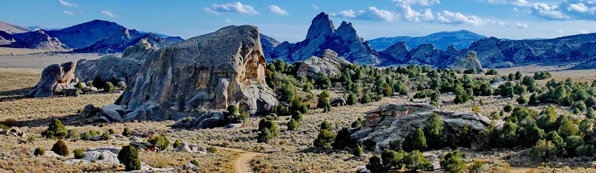
Emigrant journals describe this sculpted granite city as displaying steeples, cathedrals, pyramids, windows, and bathtubs. Some described the rocks and processes that may have formed them. Even today, the complex geology attracts professors and students alike.
City of Rocks is located in the Basin and Range physiographic province. The granite pluton of the ancient Green Creek Complex and the significantly younger Almo Pluton are best exposed here in the southern Albion Mountains. While only the tips of the plutons are visible, these ancient granites are like an open window into the earth's crust.
Once exposed, granite is subjected to weathering by wind, freezing and thawing water, salt, and other naturally corrosive chemicals. These forces work to create pinnacles, panholes, honeycombs, windows, and arches. Self-discovery of these unusual granite sculptures awaits the modern-day explorer along nearly every trail.
Ecological Crossroads
The 14,407-acre Reserve exhibits what some scientists call a biogeographic crossroads, where many plants and animals are on the edge of their habitat range. Some plants and animals of the Great Basin rarely occur farther north of here, like pinyon pine, pinyon jay, and ringtail. Colorado columbine, common in the Rocky Mountains, occurs no farther west. Longhorn plectritis, slim larkspur, and western columbine occur here, but rarely east. These overlapping ecological areas provide scientists and students an opportunity to observe the ebb and flow of living communities, which can be early warning signs or predictors of ecological change.
Over 750 species of plants and animals have been documented within the Reserve. A few species of special interest include cliff chipmunk Virginia warbler Simpson's hedgehog cactus, and pinyon pine.
We encamped at the City of the Rocks, a noted place from the granite rocks rising abruptly out of the ground. They are in a romantic valley clustered together, which gives them the appearance of a city.
—James F. Wilkins, emigrant and artist, 1849
World-Class Rock Climbing
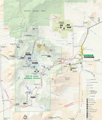 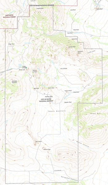 (click for larger maps) |
City of Rocks is internationally renowned for rock climbing. The granite spires range from 30 to 600 feet high. Their textured rock is tailor-made for both sport and traditional climbing. City of Rocks offers a mixture of moderate (5.6-5.9) and advanced climbs (5.10-5.13), often found side by side. Single and multi-pitch routes span features and challenges that require a full range of technique and style not generally found in one climbing area. About 700 routes have been developed. All climbers should become familiar with the Reserve's climbing guides, closures, and regulations. Information is posted at the Bath Rock kiosk and is available at the visitor center or website. Registration or permits are nol required to climb. Climbing is not permitted on rocks within the California Trail corridor.
SAFETY Do not climb unless you have training and experience. Serious accidents can occur when rock scrambling. There are no signs or fences to warn you about natural cliffs and crevices. Parents should use caution with children around these features.
In summer, park staff give climbing demonstrations. The Climbing Experience Program offers a supervised climbing experience with our staff for a small fee (equipment provided). Commercial climbing guides operate within the Reserve. Ask at the visitor center for a list of permitted and authorized guides.
PLANNING YOUR VISIT
City of Rocks National Reserve offers scenic walks near the California Trail, photography, world-class technical rock climbing, hiking, birding, mountain biking, horseback riding, picnicking, and camping.
VISITOR CENTER The visitor center for City of Rocks National Reserve and Castle Rocks State Park is in Almo, ID. Stop here for information on things to do, road conditions, restrictions that may be in effect, and to see the exhibits. Books, maps, and other park-related items to help you enjoy the Reserve are also available.
SERVICES AND FACILITIES Restaurants, gas, lodging, and groceries are available in Almo and other nearby communities. Park facilities are primitive. Potable water is available at the hand-pump wells at Emery Pass Picnic Area and Bath Rock. This water is for drinking; help us keep the water source safe for all. Treat any other water for drinking by boiling, chemicals, or adequate filtration.
HIKING Over 22 miles of hiking trails lead to climbing areas, striking features and dramatic overlooks. Always carry water and monitor the weather. Elevation ranges from 5,720 to 8,867 feet. Stay on trails to reduce the chance of becoming lost. Take note of major landmarks like Granite Peak or Smoky Mountain before departing. Tell someone where you are going.
CAMPING Camping fees and regulations are enforced. Camp in designated areas only. Cutting vegetation and gathering firewood are prohibited. Vault toilets and water stations are centrally located. Most sites include a tent pad, picnic table, and grill. Permits are required for overnight backcountry use and are available at the visitor center. Reservations are recommended for summer and can be made online at parksandrecreation.idaho.gov.
HUNTING Hunting is allowed in some areas. Before hunting, contact the Idaho Fish and Game Department for information and regulations or ask at the visitor center. "Shooting" or target practice is not permitted in the Reserve. For information on firearms regulations, check the park website.
ACCESSIBILITY We strive to make our facilities, services, and programs accessible to all. The Reserve is a mostly undeveloped primitive area. More information is available on our website or at the visitor center.
CASTLE ROCKS STATE PARK, near City of Rocks National Reserve, includes outstanding rock formations and early 1900s ranch, trails, lodge, and bunkhouse. Activities include birding, horseback riding, hiking, picnicking, rock climbing, and snowshoeing. Reservations for Smoky Mountain Campground and yurts are recommended in summer and can be made online at parksandrecreation.idaho.gov. Motor vehicle entrance fee, annual pass, or Idaho state parks passport required.
Source: NPS Brochure (2013)
|
Establishment
City of Rocks National Reserve — November 18, 1988 |
For More Information Please Visit The  OFFICIAL NPS WEBSITE |
Documents
Classification of City of Rocks National Reserve vegetation data to support the vegetation mapping program NPS Natural Resource Technical Report NPS/UCBN/NRTR-2010/313 (Ken Aho and Amy D. Forman, April 2010)
Climbing Management Plan (Draft) and Environmental Assessment, City of Rocks National Reserve (July 1995)
Comprehensive Management Plan/Development Concept Plan/Environmental Impact Statement, City of Rocks National Reserve (September 1994)
Draft General Management Plan/Environmental Impact Statement, City of Rocks National Reserve (March 2015)
Foundation Document, City of Rocks National Reserve, Idaho (February 2018)
Foundation Document Overview, City of Rocks National Reserve, Idaho (April 2018)
General Management Plan and Environmental Assessment, City of Rocks National Reserve (June 2020)
Geologic Resources Inventory Report, City of Rocks National Reserve NPS Natural Resource Report NPS/NRPC/GRD/NRR-2010/191 (T.L. Thornberry-Ehrlich, April 2010)
Grazing Management Plan, City of Rocks National Reserve, Idaho (Kenneth D. Sanders, Stephen C. Bunting and R. Gerald Wright, September 30, 1996)
Herpetological Inventory of City of Rocks National Reserve 2001 NPS Natural Resource Technical Report NPS/UCBN/NRTR-2009/200 (Jeremy P. Shive and Charles R. Peterson, April 2009)
Historic Resources Study: City of Rocks National Reserve, Southcentral Idaho (HTML edition) (Historical Research Associates, Inc., March 1996)
Junior Ranger Activity Guide, City of Rocks National Reserve (2009; for reference purposes only)
Junior Ranger (Ages 5-9), City of Rocks National Reserve (2014; for reference purposes only)
Mammal Inventory of City of Rocks National Reserve 2003 NPS Natural Resource Technical Report NPS/UCBN/NRTR-2009/198 (Thomas J. Rodhouse, Erica Madison, Katie Oelrich and Lisa K. Garrett, April 2009)
Monitoring Sagebrush-steppe Vegetation in the UCBN: October 2008 • October 2009 • October 2010
Monitoring Sagebrush-steppe Vegetation in the Upper Columbia Basin Network, 2008 Annual Monitoring Report, City of Rocks National Reserve, Hagerman Fossil Beds National Monument, John Day Fossil Beds National Monument NPS Natural Resource Technical Report NPS/UCBN/NRTR-2009/182 (Thomas J. Rodhouse, March 2009)
Museum Management Plan: City of Rocks National Reserve, Craters of the Moon National Monument and Preserve, Hagerman Fossil Beds National Monument, Minidoka Internment National Monument (Robert Applegate, Kent Bush, Brooke Childrey, H. Dale Durham, Phil Gensler, Kirstie Haertel and Diane Nicholson, 2008)
National Register of Historic Places Nomination Form
City of Rocks (Merle W. Wells, March 1986)
Natural Resource Condition Assessment, City of Rocks National Reserve NPS Natural Resource Report NPS/UCBN/NR-2012/600 (John A. Erixson and Mark V. Corrao, December 2012)
Paleontological Resource Inventory and Monitoring, Upper Columbia Basin Network NPS TIC# D-259 (Jason P. Kenworthy, Vincent L. Santucci, Michaleen McNerny and Kathryn Snell, August 2005)
Park Newspaper: c1990
Sagebrush Steppe Vegetation Monitoring in City of Rocks National Reserve: 2012 Annual Report NPS Natural Resource Data Series NPS/UCBN/NRDS-2012/407 (Devin S. Stucki and Thomas J. Rodhouse, November 2012)
Sagebrush Steppe Vegetation Monitoring in City of Rocks National Reserve, 2018 Annual Report NPS Natural Resource Report NPS/UCBN/NRR-2019/1869 (Melissa M. Nicolli, February 2019)
Sagebrush Steppe Vegetation Monitoring in Craters of the Moon National Monument and Preserve and City of Rocks National Reserve: 2010 Annual Report NPS Natural Resource Technical Report NPS/UCBN/NRTR-2011/462 (Thomas J. Rodhouse, June 2011)
Soil Survey of City of Rocks National Reserve, Idaho (2011)
Trail Management Plan: City of Rocks National Reserve, Interim: 1997-1999 (1997)
Upper Columbia Basin Network Aspen Monitoring Report 2007-2017: City of Rocks National Reserve and Craters of the Moon National Monument and Preserve NPS Natural Resource Report NPS/UCBN/NRR-2023/2538 (Eva K. Strand, Stephen C. Bunting, Timothy R. Johnson, Jeff Lonneker and Gordon Discus, July 2023)
ciro/index.htm
Last Updated: 01-Jan-2025