|
|
Fort Randall Reservoir Archeology, Geology, History |

|
THE FORT RANDALL RESERVOIR
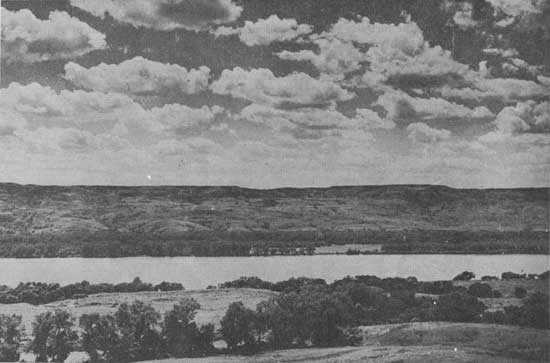
The Missouri River, a highway of major importance in our early west, follows an irregular course through the Dakotas, flowing first east, then meandering and twisting southeastward to the Nebraska border. In the Fort Randall Reservoir, the river is deeply entrenched below the surface of the rolling plain, called by physiographers The Missouri Plateau. The valley is bordered by rugged bluffs, and broken by a myriad complex of eroded canyons and ravines. Such topography is often as stark and awesome, in its own way, as are the great mountains to the west. In form and structure, the eroded hills or "breaks" bordering the Missouri are related to the well-known "badlands" of the White and Little Missouri Rivers. The Missouri breaks have a distinctive form — a dome of dark Pierre Shale and later deposits often capping strata of light-colored limestone, the well-known Niobrara Chalk, named for outcrops along the Niobrara River to the southeast. The Niobrara Chalk was formed 100 million years ago, during the Cretaceous Period, when the area was a shallow inland sea. The fossil remains of fish, reptiles, and various invertebrate creatures found in the chalky limestone attest to the profusion of life in these warm waters.
|
| The Missouri River trench in The Fort Randall Reservoir. The heavily wooded flood plain ("Bottoms") lies in the middle distance, with the dry "breaks" and uplands beyond. Photo — Missouri Basin Project, Smithsonian Institution |
In some places within the reservoir, well-preserved erosional terraces are to be found, but such features are relatively rare, especially on the west side of the river. This is presumably because of the sideward cutting of streams and the erosion of valley walls. In part, the terrace system reflects the great events of the Pleistocene Period, a time when grinding ice masses engulfed much of North America. The modern course of the Missouri River shows a remarkable correspondence with the edge of the last of the ice sheets that overran the northern Plains. Prior to damming by glacial ice, the streams flowing into the great central lowland continued their courses to the east to join a major river draining either into Hudson Bay or the Gulf of Mexico. With the channels of the feeder streams blocked, new courses were found along the edge of the ice. Thus the present Missouri River came into being.
|
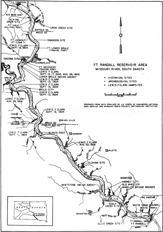
| Fort Randall Reservoir Area, Missouri River, South Dakota. (click on image for a PDF version) |
| <<< Previous | <<< Contents>>> | Next >>> |
sec3.htm
Last Updated: 08-Sep-2008