Geological History of Crater Lake
National Park
Of lakes in the United States there are many and in great variety, but of crater lakes there is but one of great importance. Crater lakes are lakes which occupy the craters of volcanoes or pits (caldera) of volcanic origin. They are most abundant in Italy and Central America, regions in which volcanoes are still active; and they occur also in France, Germany, India, Hawaii, and other parts of the world where volcanism has played an important role in its geologic history.
The one in the United States belongs to the great volcanic field of the Northwest. Crater Lake of southern Oregon lies in the very heart of the Cascade Range, and, while it is especially attractive to the geologist on account of its remarkable geologic history, it is equally inviting to the tourist and others in search of health and pleasure by communion with the beautiful and sublime in nature. By the act of May 22, 1902, a tract around this lake having an area of 159,360 acres was set aside as a national park.
According to W. G. Steel1 the lake was first seen by white men in 1853. It had long previously been known to the Indians, whose legends have contributed a name, Llao Rock, to one of the prominences of its rim. They regarded the lake with awe as an abode of the Great Spirit. Prospectors were the earliest explorers of the lake.2 The first travelers of note who visited the lake were Lord Maxwell and Mr. Bentley, who in 1872, with Capt. O. C. Applegate, of Modoc war fame, and three others, made a boat trip along its borders and named several of the prominences on the rim after members of the party.3 Mrs. F. F. Victor saw the lake in 1873, and briefly describes it in Atlantis Arisen.4The same year Mr. S. A. Clarke gave an interesting account of the lake in the December number of the Overland Monthly.
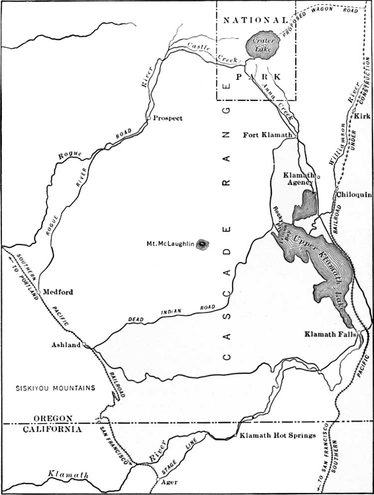
FIG. 1—MAP SHOWING ROUTES TO CRATER LAKE.
(click on image for a larger size in a new window)The first Geological Survey party visited the lake in 1883, when Everett Hayden and the writer, after spending several days in examining the rim, tumbled logs over the cliffs to the water's edge, lashed them together with ropes to make a raft, and paddled over to the island. In 1886, under the direction of Capt. C. E. Dutton, many soundings of the lake were made by W. G. Steel, and a topographic map of the vicinity was prepared by Mark B. Kerr and Eugene Ricksecker. Dutton was the first to discover the more novel and salient features in the geological history of the lake, of which he has given for his entertaining pen an all too brief account.5
Under the inspiration of the "Mazamas," a society of mountain climbers in Portland, Oreg.,6 a more extended study of the lake was made by Government parties from the Department of Agriculture, the Fish Commission, and the Geological Survey.7
FIG. 2—MAP OF CRATER LAKE NATIONAL PARK.
(click on image for a larger size in a new window)
1 The Mountains of Oregon, by W. G. Steel, 1890, p. 13.2 The discovery and early history of crater Lake, by M. W. Gorman, Mazama, Vol. I, No. 2, Crater Lake number, 1897, 159 pages. This number contains much valuable information concerning Crater Lake in addition to that referred to.
3 The names Watchman, Glacier, Llao, and Vidae, which appear on the map of the lake, have been adopted by the United States Board on Geographic Names.
4 Atlantis Arisen, by Mrs. Francis Fuller Victor. p. 179.
5 Science, Vol. VII, 1886, p. 179-182, and Eighth Annual Report of the United States Geological Survey, p. 156-159.
6 The National Geographic Magazine, Vol. VIII, 1897, page 58.
7 Crater Lake National Park, United States Geological Survey Professional Paper No. 3, 1902, 167 pages, 12 plates, by J. S. Diller, and H. B. Patton.

 |
 |