|
CRATERS OF THE MOON
Administrative History |

|
Chapter 2:
SETTING AND SIGNIFICANCE
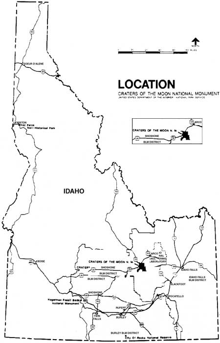
Located on the northern edge of the Snake River Plain, Craters of the Moon National Monument encompasses eighty-three of the twenty thousand square miles of lava landscape arcing across southern Idaho. The crescent-shaped plain cuts a wide and level swath through an otherwise mountainous state and defines the southern limits of the monument, while the Pioneer Mountain Range bounds it to the north. The monument's 53,545 acres embrace a small portion of the range's foothills and a vast expanse of lava flows to the south. Elevation ranges from 7,700 feet to 5,300 feet, with an elevation at the headquarters of 5,900 feet. For the most part, the monument's relief is low and studded with cinder cones. It has a semi-arid climate; hot, dry, and windy summers are followed by cold, dry, and windy winters. The average precipitation is seventeen inches a year, mostly in snowfall, which begins in November and generally lasts until April. Temperatures change dramatically. Average monthly highs fluctuate from twenty-nine degrees to eighty-four degrees Fahrenheit. In any given month it can freeze. This remote and harsh environment, however, possesses a strange beauty all its own. It is a place where in the high desert air sunlight glances off the twisted, broken, and billowed lava flows and formations in an array of shades and hues that is at once austere and captivating.

|
It is reached by U.S. Highway 20-26-93 running through the monument's northwestern corner, which connects an otherwise isolated area with several major population centers in southern Idaho: Twin Falls, Idaho Falls, and Pocatello. Offering a two-hour drive from these locations, the highway also routes tourists between Yellowstone National Park and the region of Sun Valley and the Sawtooth National Recreation Area. The monument attracts a majority of its summer visitors from vacationers en route to these and points beyond.
Locally, the monument traverses land in two counties. Blaine County, comprising 13,361 acres of the monument, contains the tourist destination of Sun Valley. Butte County, in which the remaining 40,184 acres lie, is more rural, and includes Arco, the nearest town to the monument. Arco, the county seat, is eighteen miles northeast of the area and, with approximately twelve hundred residents, offers a full range of services. It is considered the major gateway town for the monument. Of the lands surrounding the monument nearly all are under Bureau of Land Management jurisdiction, and are used for sheep and cattle grazing, and mining; those lands south of the highway and adjacent to the monument fall under the BLM's Great Rift Wilderness Study Area classification.

|
PURPOSE
As stated in President Calvin Coolidge's proclamation of May 2, 1924, the purpose of Craters of the Moon is to preserve an area of unusual scientific and educational value and general interest
which contains a remarkable fissure eruption together with its associated volcanic cones, craters, rifts, lava flows, caves, natural bridges, and other phenomena characteristic of volcanic action; and...contains many curious and unusual phenomena of great educational value and has a weird and scenic landscape peculiar to itself. [1]
GEOLOGIC SIGNIFICANCE
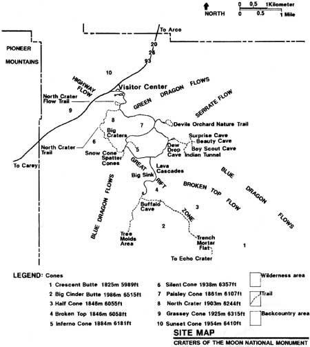
Established as a natural monument, Craters of the Moon preserves some of the world's best examples of basaltic volcanism in a small geographic area. It is also just a small section of the much larger geologic province of the Snake River Plain, and represents some of the plain's most recent eruptions, binding the monument's geologic story with the Snake River Plain's. Beginning nearly fifteen million years ago, volcanic activity formed the plain as lava flow after lava flow emerged from the earth through linear cracks. These openings and the concentration of volcanic formations along them developed volcanic rift zones. They are common across the Snake River Plain, occurring at weakened sections of the earth's crust from which magma under pressure erupted. Craters of the Moon National Monument lies atop the Great Rift, the plain's most extensive rift zone. Designated a national natural landmark in 1971, it runs for some sixty miles from northwest to southeast, and from one and a half to five miles in width. The rift is the source of over sixty lava flows, twenty-five cinder cones, and eight eruptive vents that make up the Craters of the Moon Lava Field.
The monument encloses thirteen miles of the rift, the northern corner of the Craters of the Moon Lava Field, and most of the field's cones and fissures. The lavas exposed here are young, formed during eight eruptive periods from fifteen thousand to two thousand years ago. Lasting about one thousand years and occurring in cycles of about two thousand years, the volcanic eruptions were quiet rather than explosive; basaltic lava contained less silica than rhyolitic lava which, for example, was responsible for the violent eruption of Mount Saint Helens in 1980. At Craters of the Moon, frothy fountains of lava spewed from gashes in the earth, building cinder cones and conical vents. As eruptions subsided, molten rock was pumped out in smaller and more localized flows, until all activity ceased. Yet Craters of the Moon is by no means dead; geologists predict another eruption in the next thousand years.
Three types of lava flows are found in the monument: pahoehoe, aa, and blocky. Pahoehoe, a Hawaiian term meaning "ropey," covers more than half of the monument. Its fluid consistency formed rivers of lava that hardened into relatively smooth, glossy surfaces that, while sometimes flat, are often twisted, rolling, or coiled. Hawaiian for "rough," aa flows formed mostly when pahoehoe flows cooled and thickened, and are anything but smooth, owning sharp, jagged surfaces. A type of aa lava, yet containing more silica, blocky lava is thick and often dense, smooth and glassy. Among the other features found in the monument are cinder cones, spatter cones, vents, fissures, rafted blocks, lava tubes, and tree molds. Visually, the lavas are variegated. Blacks, dark browns, and grays, oxidized reds, yellows, and pahoehoe's iridescent shades of blue and green meet the eye. [2]
Finally, and perhaps most important, the monument's geologic significance was recognized prior to scientific advances that have accurately dated the flows and exposed the area's relationship to the Snake River Plain. Research, in the process of revealing the secrets of the Great Rift, has only increased the monument's significance.

|
RESOURCES
In addition to its volcanic landscape the monument encompasses around four thousand acres of the foothills of the Pioneer Mountain Range in its northern unit. Together these lands support a variety of natural and cultural resources.
Although the monument's high desert environment appears lifeless, fauna and flora are surprisingly diverse. While not overly abundant, they are well adapted to survive in the semi-arid climate, having developed ways to resist and evade heat, aridity, and wind. Nearly fifty mammal and 150 bird species have been cataloged. The most common are mule deer, coyote, yellow-bellied marmot, golden-mantled ground squirrel, yellowpine chipmunk, mountain bluebird, Clark's nutcracker, violet-green swallow, and raven. In addition, more than two thousand insects, eight reptiles, and one amphibian have been identified.
Similarly, vegetation is varied, even though the majority of the monument's surface is composed of barren lava flows, and plant life is exposed to the monument's severe conditions. More than three hundred plant species are native to Craters of the Moon. Cinder cones support, among other things, limber pine, antelope bitterbrush, and dwarf buckwheat. Lava flows, varying in age and habitat, support lichens, syringa, tansybush, rubber rabbitbrush, cinquefoil, and wire lettuce. Wildflowers such as the monkeyflower, blazing star, bitterroot, paintbrush, and arrow-leaved balsamroot clothe the seemingly barren landscape in short bursts of color. In the watershed of the northern unit, Douglas-fir, quaking aspen, mountain snowberry, sagebrush, and riparian vegetation are found. The monument also has some unique types and areas of vegetation. Nearly a quarter of the monument is covered by shrub steppe vegetation, a type once common to Idaho and now rare. Craters of the Moon also contains kipukas, islands of vegetation existing in older lava flows and encircled by younger flows; many of them, the Carey Kipuka in particular, protect remnants of relatively pristine vegetation.
Scarcity of surface water is inherent to Craters of the Moon. Waterholes are scattered throughout the area in lava depressions. Insulated in lava cavities, ice and snow can be found throughout the year. The presence of water, frozen or thawed, in the semi-arid environment and hot summer months presents a strange and unique phenomenon. Something of a mystery, waterholes have unknown origins. Some pools have decreased significantly, while others have dried up entirely. Although undependable for human consumption, the waterholes are important for wildlife. The monument's domestic water supply, on the other hand, comes from the springs of Little Cottonwood Creek, draining the Pioneer Mountains. There, the monument receives its water from four enclosed springs, piped to a 150,000-gallon reservoir at the headquarters site where it is treated and stored. [3]
Air quality is one of the monument's primary resources. The Clean Air Act of 1977 classified the monument's wilderness area, 43,243 acres, as a class I airshed, mandating active management by park staff to protect against deterioration. The remaining airshed is class II. [4]
Although the monument is known more for its natural resources, cultural resources compose an important if less understood and documented aspect of management. Numerous archaeological sites have been recorded within the monument. They consist mainly of sparsely scattered surface artifacts and quarry sites. Further research will determine their significance, as more intensive study of the entire monument occurs. [5]
There are also a few historic sites and structures of interest. Listed in the National Register of Historic Places, Goodale's Cutoff, a section of the Oregon Trail, crossed the northern unit of Craters of the Moon. However, little fabric remains, and assessment of the trail's importance awaits future study. Most structures that might be historic today were removed during the Mission 66 program. Only a log comfort station and warehouse remain of this earlier era. Over fifty years of age, and somewhat altered and deteriorated, they have yet to be evaluated for the National Register. [6]
| <<< Previous | <<< Contents>>> | Next >>> |
adhi/chap2.htm
Last Updated: 29-Oct-1999