|
El Camino Real de Tierra Adentro National Historic Trail New Mexico-Texas |
|
 NPS photo | |
The Trail Yesterday
El Camino Real de Tierra Adentro is the earliest Euro-American trade route in the United States. Tying Spain’s colonial capital at Mexico City to its northern frontier in distant New Mexico, the route spans three centuries, two countries, and 1,600 miles. El Camino Real was blazed atop a network of footpaths that connected Mexico’s ancient cultures with the equally ancient cultures of the interior West.
El Camino Real de Tierra Adentro began in Mexico City. As the “Royal Road of the Interior Lands,” the frontier wagon road brought Spanish colonists into today’s New Mexico.
Once travelers crossed the arid lands above Ciudad Chihuahua, they followed the wide Rio Grande Valley north into New Mexico. Many of the historic parajes (campsites) and early settlements created by the Spanish colonists became today’s modern cities in the Rio Grande Valley. In the United States, the trail stretched from the El Paso area in Texas, through Las Cruces, Socorro, Belen, Albuquerque, and Santa Fe to Ohkay Owingeh (San Juan Pueblo), the first Spanish capital in New Mexico. In Mexico, the historic road runs through Chihuahua, Durango, Zacatecas, San Luis Potosí, Aguascalientes, Guanajuato, and Querétaro to Mexico City.
The trail fostered exchanges between people from many backgrounds, including American Indians, Spaniards, Mexicans, New Mexicans, and Americans.
From 1598, when the first Spanish colonizing expedition made its way up the Rio Grande, through the 1870s, the wagon road was the main thoroughfare between Mexico and New Mexico. The trail corridor is still very much alive, 125 years after the railroad eclipsed its commercial use.
The Trail Today
The trail corridor nurtures a lively exchange of ideas, customs, and language between Mexico and the American Southwest. Recognition as an international historic trail commemorates a shared cultural and geographic heritage. It helps eliminate cultural barriers and enriches the lives of people living along El Camino Real de Tierra Adentro.
Added to the National Trails System in October 2000 by the U.S. Congress, El Camino Real de Tierra Adentro National Historic Trail extends 404 miles from El Paso, Texas, to Ohkay Owingeh Pueblo, New Mexico. Visit some of the places featured here to experience the trail today.
Tomé Hill
This distinctive conical hill has served as a natural landmark for
travelers from prehistoric times into the present. Petroglyphs carved
into its flanks and crosses at the top attest to its significance for
Indian peoples and Catholic pilgrims alike.
Mesilla Plaza
Mesilla, New Mexico, began its life as a part of Mexico, a new community
established for Mexican citizens who found themselves on the U.S. side
of the border following the Treaty of Guadalupe Hidalgo in 1846. Those
same settlers found themselves back in the U.S. again after the Gadsden
Purchase of 1853. The new town became a commercial crossroads for the
Mesilla Valley. The Butterfield Overland Stage stop was one block from
the Plaza, and travelers on El Camino Real could stop in Mesilla on
their way to Chihuahua and Santa Fe.
Fort Craig National Historic Site
Fort Craig is the largest of eight U.S. forts built along El Camino Real
de Tierra Adentro during New Mexico’s Territorial Period. Between 1854
and 1884, Fort Craig was home to Buffalo Soldiers of the 9th Cavalry and
38th and 125th Infantry, the predominantly Hispanic New Mexico
Volunteers and New Mexico Militia, and historic figures including Kit
Carson, Rafael Chacón and Captain Jack Crawford.
Fort Selden State Monument
Fort Selden was established in 1865 to protect settlers and travelers in
the Mesilla Valley. Built on the banks of the Rio Grande just north of
the traditional parajes of Doña Ana and Robledo, this adobe fort housed
units of the U.S. Army’s infantry and cavalry. The fort remained active
until 1891, five years after Geronimo’s capture and six years after the
railroad had taken over El Camino Real’s role in commercial freight and
transport.
Keystone Heritage Park
Keystone Heritage Park, El Paso, Texas, preserves a remnant of the rich
riverine environment of the Rio Grande. The Archaic pit house
settlement, where small bands foraged for wild plants and animals in the
rich marshlands adjacent to the Rio Grande, is 4,000 years old.
Coronado State Monument/Kuaua Pueblo
When Francisco Vásquez de Coronado arrived at Kuaua Pueblo in 1540, he
was leading an expeditionary force of 300 soldiers and 800 Indian allies
on a march to locate the fabled Seven Cities of Cibola. Instead of the
golden city they expected, the Spanish found a thriving multistory adobe
pueblo with more than a thousand villagers.
Palace of the Governors
This modest, single-story adobe is the oldest continuously occupied
governmental building in the U.S. Construction began in 1610. Over the
years the Palace has been converted to an Indian Pueblo, housed Spanish
and Mexican governors, and served as a Territorial Capitol. Since 1909
the Palace has been the heart of New Mexico’s State Museum system. The
Palace sits on the north side of the Santa Fe Plaza.
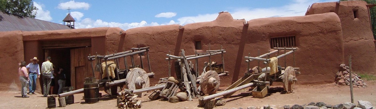
El Rancho de las Golondrinas
Today a living history museum dedicated to colonial New Mexico, this was
once an important paraje, or campsite, on El Camino Real. About
15 miles from the Santa Fe Plaza, the rancho offered travelers a chance
to freshen up before reaching the capital city or to make repairs to
gear following a shake-down journey on the trail heading south.
4,000 BP
Archaic pit house village is established at edge of the Rio Grande, now
in Keystone Park. Prehistoric occupation of Rio Grande Valley dates back
to at least 12,000 years ago.
1521
Aztec ruler Moctezuma II surrenders Tenochtitlán to Spanish conquistador
Hernán Cortés. Mexico City is established on the site of the Aztec
capital.
1540
Francisco Vasquez de Coronado and his army of 1,100 camp near the Tiwa
pueblo of Kuaua.
1598
Juan de Oñate leads first Spanish colonists up the Rio Grande along El
Camino Real de Tierra Adentro. The caravan starts with 83 laden carts.
By the six month journey’s end, only 61 carts remain with the column of
129 soldiers, their families, and thousands of stock animals. The column
traveled as fast as a pig could trot.
1608-1610
Villa de Santa Fe is established, relocating the Spanish capital from
San Juan de los Caballeros, on Ohkay Owingeh Pueblo lands.
1643-1662
Spanish ranches and villages are established along El Camino Real north
of Isleta Pueblo, including Pajarito and Atrisco, independent
communities now within the greater Albuquerque area.
1670
German trader Bernardo Gruber dies on the Jornada del Muerto, fleeing
jail at Sandia Pueblo and the Spanish Inquisition.
1680
On the night of August 10, 1680, nearly two dozen Pueblos revolt over
the Spanish practices of extracting tribute, forcing conversion to
Catholicism, and brutally suppressing Native religion. This act of
resistance against European colonists regains the Pueblos their homeland
for 12 years.
1692
Spanish return to New Mexico, rebuild missions and settlements.
1706
Villa of Albuquerque is established, with today’s “Old Town” and Plaza
as its historic center.
1739
The Tomé grant is settled after the Rio Grande shifts west, creating an
inner valley branch of El Camino Real through the Tomé Plaza.
1760
Still a rough camp in 1760, the paraje of Doña Ana is settled as a town
in the 1840s.
1789
San Elizario is established as a military presidio to protect citizens
of El Paso del Norte from Apache attacks.
1807
U.S. Lieutenant Zebulon Pike illegally enters Spanish territory while
exploring the West. Pike is captured and taken down El Camino Real to
Mexico City.
1821
Mexico is freed from Spain. Santa Fe Trail opens with the arrival of
William Becknell’s trading party from Missouri. El Camino Real de Tierra
Adentro becomes known as the “Chihuahua Trail” for traders moving goods
through Santa Fe from the eastern U.S.
1846
Missouri volunteers under Colonel Alexander W. Doniphan defeat a Mexican
unit at the Battle of Bracitos, go on to take El Paso del Norte and
march into Chihuahua.
1848
Treaty of Guadalupe Hidalgo establishes American control over about half
of Mexico’s lands, including the lands traversed by El Camino Real north
of El Paso del Norte.
1850
New Mexico becomes an incorporated, organized territory of the U.S. on
September 9, 1850.
1853
American-Mexican border is redefined through the Gadsden Purchase, which
brought a strip of land from Texas to California into American hands,
29,142,400 acres for $10 million.
1862
Battle of Valverde, first major battle of the Civil War in the Southwest,
takes place north of Fort Craig, February 1862.
1865
Fort Selden is established to control the Mesilla Valley.
1878
The region's first operational railroad, the Atchison, Topeka &
Santa Fe Railway, enters New Mexico Territory by way of Raton Pass; the
rails reach El Paso, Texas, in 1881.
1909
New Mexico Territorial Highway Commission appropriates funds to
re-engineer La Bajada section of El Camino Real for automobile
traffic.
1912
New Mexico achieves statehood; State Highway 1 incorporates many
sections of El Camino Real.
1926
U.S. Route 66 is built over parts of El Camino Real, including the steep
descent known as La Bajada.
1935
New Mexico’s roadside historic markers begin to tell the trail’s
history. In 1992 many of the 82 El Camino Real markers are installed as
part of the Columbus Quincentenary Commemorations.
2000
El Camino Real de Tierra Adentro is added to the National Trails System
on October 13, 2000.
2003
El Camino Real de Tierra Adentro Trail Association is formed.
THE FIRST CAPITAL
In 1598, Juan de Oñate's original colonizing party was welcomed at Ohkay
Owingeh Pueblo, christened "San Juan de Los Caballeros" by the
Spaniards. By the winter of 1599, the colony had moved to an outlying
pueblo, Yungue, which they renamed "San Gabriel." In 10 years the
capital was relocated once again to Santa Fe.
RIO ABAJO, RIO ARRIBA, AND LA BAJADA
In the Spanish colonial period, New Mexico was divided into two
administrative units. These were the Río Abajo, or lower river, and the
Río Arriba, or upper river. The dividing line was the escarpment known
as "La Bajada," north of Cochiti Pueblo.
THE RIO GRANDE
The Rio Grande is New Mexico's major river. Its valley stretches the
full length of the state and holds the best agricultural land, the most
extensive wetlands and wildlife, and is the state's major travel
corridor. Known to Tewa Pueblo peoples as P'Osoge, or the big river, the
Spanish called it the Río Bravo, or wild river, as well as El Río Grande
del Norte, or the big river of the north. The Rio Grande forms the
border between New Mexico and Texas near El Paso, and the international
border between Mexico and the United States from El Paso and Ciudad
Juárez.
THE CIVIL WAR IN NEW MEXICO
Confederate troops marched into New Mexico Territory in June 1861. They
battled Union forces and New Mexico reserves at Valverde, and took both
Albuquerque and Santa Fe. The Confederates were turned back at Glorieta
Pass, east of Santa Fe, before they could reach the gold and silver
fields of Colorado.
THE JORNADA DEL MUERTO
The "Dead Man's Journey" is the longest of the waterless stretches of El
Camino Real that the Spanish called jornadas. The "dead man" of this 60
mile, two-day trek, was Bernardo Gruber, who died on the Jornada while
fleeing the Holy Office of the Inquisition in 1670.
PARAJES
The caravans made camp every 20 miles or so on the journey from northern
Mexico to northern New Mexico. These simple campsites, or parajes,
served travelers for centuries. Until the 19th century, none of the
parajes on the Jornada del Muerto—Paraje San Diego, Paraje del
Perrillo, Paraje del Aleman, Las Peñuelas, Laguna del Muerto, El
Contadero, Valverde, and Fray Cristobal—were settled
permanently.
PRESIDIOS AND FORTS
The Spanish established a handful of presidios, or forts, along the
trail. El Paso del Norte and San Elizario controlled and protected the
settlements near present-day Juarez, and the Presidio de Santa Fe
protected the capital and northern New Mexico. After 1848 the Americans
developed their own military system of smaller posts along the trail on
the Jornada del Muerto, and at Santa Fe, El Paso, Valverde, Dona Aña, La
Joya, and Socorro.
Visiting the Trail Today
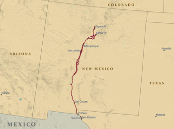 (click for larger map) |
El Camino Real de Tierra Adentro National Historic Trail runs through the heart of the Rio Grande Valley. The Bureau of Land Management and the National Park Service administer the Trail together to foster trail preservation and public use. These agencies work in close partnership with El Camino Real de Tierra Adentro Trail Association, the Indian tribes and Pueblos—whose ancestors greeted the first Spanish colonists—as well as state, county, and municipal governmental agencies, private landowners, nonprofit heritage conservation groups, and many others. Trail sites are in private, municipal, tribal, federal or state ownership. Please ask for permission before visiting any trail sites on private lands and check with public sites for visiting hours and regulations. Follow trail signs to retrace El Camino Real de Tierra Adentro along highways, streets, and backcountry roads.
Visit these sites to learn more about the trail.
Historic Sites
Palace of the Governors
105 West Palace Avenue, Santa Fe, NM
www.palaceofthegovernors.org/
El Rancho de las Golondrinas
334 Los Pinos Road, La Cienega, NM
www.golondrinas.org
Coronado State Monument/Kuaua Pueblo
Both Kuaua Pueblo and the nearby Coronado campsite have been studied by
archaeologists and their history is on display at the New Mexico State
Monument near Bernalillo.
State Highway 550/44, 1.27 miles west of Interstate 25, Exit 242
www.nmmonuments.org/
Casa San Ysidro: The Gutierrez-Minge House
The Gutierrez-Minge House is in the village of Corrales, just north of
Albuquerque. The original home, built by the Gutierrez family, dates to
the 1870s. Today Casa San Ysidro includes a recreated 19th century
rancho, a small family chapel, central plazuela, and an enclosed corral
area.
973 Old Church Road, Corrales, NM
www.cabq.gov/museum/history/casatour.html
The Gutierrez-Hubbell House
The Gutierrez-Hubbell House is a 5,800 square foot adobe hacienda that
dates to the 1840's. It has been used as a private residence,
mercantile, stagecoach stop, post office, and Pajarito village gathering
place along El Camino Real.
6029 Isleta Boulevard S.W., Albuquerque, NM
www.bernco.gov/live/standalone.asp?dept_id=3946&link_id=191954
Tomé Hill
Access at Tomé Hill Park, intersection of Tomé Hill Road (Rio del Oro
Loop North) and La Entrada Road, Tome, NM
www.v-i-a.org/tomehill.htm
Fort Craig National Historic Site
South of Socorro on County Road 273, off New Mexico Highway 1, use
Interstate 25 Exit 115 northbound, or Exit 124 southbound.
www.blm.gov/nm/st/en/prog/recreation/socorro/fort_craig.html
Jornada del Muerto Trailheads
County Roads A013, E070, Sierra and Doha Ana Counties
For more information, contact Las Cruces District Office,
Bureau of Land Management.
1800 Marquess Street, Las Cruces, NM
www.blm.gov/nm/st/en/fo/Las_Cruces_District_Office.html
Fort Selden State Monument
North of Las Cruces off Interstate 25, Exit 19, on New Mexico State
Road 157, Fort Selden Road.
www.nmmonuments.org/inst.php?inst=10
Mesilla Plaza
Bounded by Calle de San Albino, Calle de Guadalupe, Calle de Santiago
and Calle de Parian, Mesilla, NM
From Interstate 25, take Interstate 10 west to Mesilla Exit 140, turn
south one mile on Highway 28 to Calle de Santiago.
www.oldmesilla.org/
Keystone Heritage Park
4200 Doniphan Drive, El Paso, TX
www.keystoneheritagepark.org/
Visitor Centers and Museums
Albuquerque Museum of Art & History
The city's museum preserves and displays artistic and historic items
from early Spanish settlement to the present. Exhibit highlights include
El Camino Real, Hispanic life, the Civil War, and New Mexico statehood.
The museum is near Albuquerque's Old Town, across from Tiguex Park.
2000 Mountain Road, Albuquerque, NM
www.cabq.gov/museum/
Bosque del Apache National Wildlife Refuge
Bosque del Apache, or woods of the Apache, was the Spanish name for the
extensive wetlands and forest along the Rio Grande below Socorro, New
Mexico. Today, this region is one of the Southwest's premier wildlife
refuges. Birders from around the world come during fall and winter to
see sandhill cranes, snow geese, and ducks. State Highway 1, 8 miles
south of Interstate 25, Exit 139.
www.fws.gov/southwest/refuges/newmex/bosque/index.html
El Camino Real International Heritage Center
Thirty miles south of Socorro, NM on County Road 1598, Center visitors
step back in time and explore the history and heritage of El Camino Real
from Zacatecas, Mexico, to the plaza in Santa Fe. One of New Mexico's
State Monuments, the Center overlooks the Jornada del Muerto, the lower
Rio Grande and the historic trail.
County Road 1598, Interstate-25, Exit 115
www.caminorealheritage.org/
El Paso Museum of History
The museum promotes the understanding and significance of the rich
multicultural and multinational history of the border region known as
"The Pass of the North."
510 N. Santa Fe Street, El Paso, TX
www.elpasotexas.gov/history/
Chamizal National Memorial
The Chamizal Convention of 1963 resulted in the peaceful settlement of a
century-long boundary dispute between the U.S. and Mexico. Visitors
traveling east or west on 1-10, exit at Hwy 54 and follow the brown
Chamizal National Memorial directional signs. If traveling south on Hwy
54, take exit marked Juarez, Mexico. DO NOT proceed onto the
International Bridge of the Americas, but turn right onto Paisano
Street, and continue to follow signs toward Chamizal.
800 S. San Marcial, El Paso, TX
www.nps.gov/cham
Trail Administrators
For more information, contact:
Bureau of Land Management
New Mexico State Office
P.O. Box 27115
Santa Fe, NM 87502-0115
www.blm.gov/nm
National Park Service
National Trails Intermountain Region
P.O. Box 728
Santa Fe, NM 87504-0728
www.nps.gov/elca
Trail Association
El Camino Real de Tierra Adentro Trail Association (CARTA)
P.O. Box 15162
Las Cruces, NM 88004
www.caminorealcarta.org/
Source: NPS Brochure (undated)
|
Establishment El Camino Real de Tierra Adentro National Historic Trail — October 13, 2000 |
For More Information Please Visit The  OFFICIAL NPS WEBSITE |
Documents
A Management Plan for El Camino Real de Tierra Adentro on State Lands in New Mexico (Elizabeth A. Oster and Michael L. Elliott, April 2019)
Chronicles of the Trail: Quarterly Journal of the Camino Real de Tierra Adentro Trail Association (©Camino Real de Tierra Adentro Trail Association)
2007 (Vol. 3): No. 1: Winter • No. 2: Spring • No. 3: Summer • No. 4: Fall
2008 (Vol. 4): No. 1: Winter • No. 2-3: Spring & Summer • No. 4: Fall
2009 (Vol. 5): No. 1: Winter • No. 2: Spring • No. 3: Fall
2010 (Vol. 6): No. 1: Winter • No. 2: Spring • No. 3: Summer • No. 4: Fall
2010 (Vol. 6) (Spanish): No. 1: Winter • No. 2: Spring
2011 (Vol. 7): No. 1: Winter • No. 2: Spring • No. 3: Summer / Fall
2012 (Vol. 8): No. 1: Winter/Spring • No. 2: Fall
2013 (Vol. 9): No. 1: Winter/Spring • No. 2: Summer
2014 (Vol. 10): No. 1: Winter
Draft Comprehensive Management Plan/Environmental Impact Statement, El Camino Real de Tierra Adentro National Historic Trail (August 2002)
El Camino Real de Tierra Adentro New Mexico BLM Cultural Resources Series No. 11 (Gabrielle G. Palmer, June-el Piper and LouAnn Jacobson, eds., 1993)
El Camino Real de Tierra Adentro: Volume Two New Mexico BLM Cultural Resources Series No. 13 (Gabrielle G. Palmer and Stephen L. Fosberg, comp., June-el Piper, ed., 1999)
Fort Craig (F. Stanley, 1963)
Fort Craig: The United States Fort on the Camino Real Collected Papers of the First Fort Craig Conference (Charles Carroll & Lynne Sebastian, 2000)
Guardian of the Trail: Archeological & Historical Investigations at Fort Craig New Mexico Bureau of Land Management Cultural Resources Series No. 15 (Peggy A. Gerow, 2004)
Junior Ranger Program, El Camino Real de Tierra Adentro National Historic Trail (Date Unknown; for reference purposes only)
!La Gran Aventura!: El Camino Real de Tierra Adentro — Un Sendero Real Entre la Ciudad de México y Santa Fé (SRI Foundation, September 2003)
National Register of Historic Places Nomination Form
Camino Real in New Mexico, AD 1598-1881 (Thomas Merlan, Michael P. Marshall and John Roney, May 1, 2010)
Newsletter: El Camino Real de Tierra Adentro Trail Association: Vol. 1 No. 3: July 13, 2016 • Vol. 1 No. 4: October 2016 • Vol. 2 No. 1: January 2017 (©Camino Real de Tierra Adentro Trail Association)
The Grand Adventure!: El Camino Real de Tierra Adentro — The Royal Road from Mexico City to Santa Fe (SRI Foundation, September 2003)
Visitor's Guide to El Camino Real National Scenic Byway in New Mexico (Beth Keyohara, undated)
elca/index.htm
Last Updated: 10-Mar-2025