|
El Malpais National Monument New Mexico |
|
 NPS photo | |
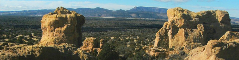
Where Sharp Lava Meets Smooth Sandstone
El Malpais means "the badlands" in Spanish and is most commonly pronounced el-mal-pie-EES—yet there is much good in these badlands. In satellite photos of New Mexico, lava flows blanketing much of El Malpais National Monument look like a huge lake southwest of Grants. The imagery shows dominant landscape features—lava flows, mountain ranges, and mesas—that mask deeper mysteries and wonders.
Lava that poured out of McCartys Crater 3,900 years ago created a new land surface. Volcanic features include cinder cones, a lava tube cave system extending at least 17 miles, and fragile ice caves. The malpais landscape is primal, pristine, and ancient, but this living remnant of the old Southwest is also surprisingly modern.
Like the ancient Douglas fir trees that thrive among this rugged lava terrain, life uniquely adapts to El Malpais. Continuing research leads to new knowledge about volcanic landscapes. Because early scientific knowledge of volcanoes was developed in the Hawaiian islands, lava types and many features in El Malpais bear Hawaiian names. Smooth, ropy lavas are pahoehoe, pronounced pah-HOY-hoy. Sharp, jagged lavas that rip up all but the sturdiest hiking boots are 'a'a, pronounced AH-ah.
Kipukas are undisturbed areas that lava flows encircled but did not cover. These ecological islands of vegetation are living remnants of native plant and animal communities. Study of these kipukas will yield benchmark information for restoring disturbed portions of El Malpais.
In addition to the rich variety of natural environments, this area offers evidence of prehistoric cultures. People have interacted with the El Malpais landscape for over 10,000 years. Peak human occupation occurred between 950 and 1350, when El Malpais was at the fringe of a political and economic system centered in Chaco Canyon, 80 miles to the north. As participants in this system, the ancient Puebloans established outlying communities along the lava flows' edges. When the Chacoan system collapsed in the late 1100s, these outlying communities continued to thrive.
Although the ancestral Puebloans left El Malpais by the mid-1300s, they did not disappear. They moved to the Acoma area and established a new homeland. These cultural resources are kept alive by the spiritual and physical presence of the Puebloan peoples of Acoma, Laguna, and Zuni, and the Ramah Navajo. These American Indians make their homes here and continue their traditional uses.
In 1540 Coronado's expedition encountered two major Indian pueblos—Zuni and Acoma—flanking El Malpais. When New Mexico became a US territory in 1848, Anglo explorers considered El Malpais a hindrance. Anglos did not move into the area in significant numbers until the Great Depression of the 1930s. Many were homesteaders or sheepherders escaping the flood of immigration to other parts of the West. Throughout the centuries El Malpais has challenged American Indian, Spanish, and Anglo travelers. Today, ancient trails remind us how those who crossed this rugged landscape persevered.
People of El Malpais
The lands of El Malpais have figured in Acoma, Laguna, Zuni, and Ramah Navajo cultures for thousands of years. Their traditional uses—gathering herbs and medicines, paying respect, and renewing ties—continue today.
Protecting these lands ensures the continuation of traditions integral to this region's cultural diversity.
As you travel El Malpais, please respect private and Indian lands.
Explore El Malpais
Sandstone Bluffs Overlook Take an easy drive to vistas of El Malpais and surrounding country.
Lava Falls Area Visit McCartys flow, the youngest lava flow in the region. Many plants have adapted to this harsh environment.
Zuni-Acoma Trail This ancient trade route crosses four major lava flows. The hike is 7.5 strenuous miles one-way over rugged lava.
El Calderon Area Explore the monument's oldest lava flow in this forested area. Do not enter caves.
Big Tubes Area See some of the 10,900-year-old Bandera lava flow and its 17-mile-long tube and trench system. Do not enter caves.
Chain of Craters Backcountry Byway Drive this unpaved road along a rift where lava flowed 200,000 years ago and see the 30 cinder cones left behind.
Continental Divide Trail Hike a portion of this national trail where it crosses El Malpais. Please ask at visitor centers for specific information.
Plan Your Visit
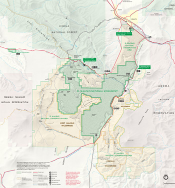 (click for larger map) |
El Malpais lies in the high desert lands midway between Gallup and Albuquerque, NM. To the east are lands of the Acoma and Laguna people; to the west are those of the Ramah Navajo and Zuni.
El Malpais Visitor Center, south of I-40 at exit 85, has exhibits, audio-visual programs, a bookstore, and a trip-planning area.
El Malpais Information Center (NPS), 23 miles south of I-40 on NM 53, has exhibits, a bookstore, and a picnic area. Open seasonally.
Accessibility We strive to make our facilities, services, and programs accessible to all. For more information ask a ranger, call, or check our website.
Camping Please ask at the El Malpais Visitor Center for dispersed camping rules.
Other Services Motels, camping, food, and other services are in and near Grants.
Safety and Regulations
Water Carry one gallon of water per person per day in summer. Do not drink surface water.
Driving Always stop at a visitor center to learn about roads safe for your vehicle. Vehicles must stay on designated roads and are prohibited in wilderness areas.
Hiking Lava rock is sharp! Wear sturdy boots. Watch out for cactus spines and sharp yucca leaves. When a hiking route is marked by cairns (rock piles), do not leave your cairn before you have the next cairn in sight. Leave cairns in place.
Lava Tube Caves You must have a free permit to enter lava tube caves that are open to the public; entry into all others is prohibited. Ask at El Malpais Visitor Center.
Hunting and Trapping Hunting and trapping are prohibited in the park. For firearms regulations, check the park website.
Preservation Federal law protects historic and natural features in the park. Do not excavate, disturb, deface, or destroy any structure, exhibit, artifact, animal, or plant.
Venomous Animals Rattlesnakes and scorpions live here. Non-venomous bullsnakes can act like rattlesnakes. If you encounter a snake, do not disturb it.
Source: NPS Brochure (2018)
|
Establishment
El Malpais National Monument — December 31, 1987 |
For More Information Please Visit The  OFFICIAL NPS WEBSITE |
Documents
A Comparison of Cave Microbial Communities to Cave Roosting Bat Microbiota in El Malpais National Monument, USA (©Nicole A. Caimi, Master's Thesis University of New Mexico, December 2019)
Agua Fria Creek Restoration Project: El Malpais National Monument, Cibola County, New Mexico: Cultural Resources Survey Draft (SWCA Environmental Consultants, May 31, 2002)
Birding Guide to El Malpais (Ken Jones, Date Unknown)
Characterizing Morphology of Lava Tubes in El Malpais National Monument Using Ground Penetrating Radar and Lidar (N.M. Bardebelias, J.W. Holt, C.W. Hamilton, M.S. Christoffersen and N.K. Hadland, extract from 52nd Lunar and Planetary Science Conference, 2021)
Ecological Inventory of Lava Tube Caves, El Malpais National Monument, New Mexico (Jut Wynne, March 9, 2011)
El Malpais (Charles H. Maxwell, extract from New Mexico Geological Society 33rd Annual Fall Field Conference Guidebook, 1982)
Field-trip Guide to the Geochronology of El Malpais National Monument and the Zuni-Bandera Volcanic Field, New Mexico (HTML edition) New Mexico Bureau of Mines & Mineral Resources Bulletin 149 (A. William Laughlin, Robert W. Charles, Kevin Reid and Carol White, 1993)
Fire Management Plan for the Bureau of Land Management El Malpais National Conservation Area and National Park Service El Malpais National Monument, New Mexico Review Copy (December 2000)
Foundation Document, El Malpais National Monument, New Mexico (September 2014)
Foundation Document Overview, El Malpais National Monument, New Mexico (October 2014)
General Geology and Development of Lava Tubes in New Mexico's El Malpais National Monument (Bruce W. Rogers, 6th International Symposium on Vulcanospeleology, 1992)
General Management Plan, Environmental Assessment, Wilderness Suitability Study: El Malpais National Monument, New Mexico Draft (January 1990)
General Management Plan, Wilderness Suitability Study: El Malpais National Monument, New Mexico (October 1990)
Geologic Resources Inventory Report, El Malpais National Monument NPS Natural Resource Report NPS/NRPC/GRD/NRR-2012/578 (K. KellerLynn, September 2012)
In the Land of Frozen Fires: A History of Occupation in El Malpais Country (HTML edition) Southwest Cultural Resources Center Professional Papers No. 32 (Neil C. Mangum, 1990)
Junior Ranger Activity Book, El Malpais National Monument (2018; for reference purposes only)
Multi-century history of wildfire in the ponderosa pine forests of El Malpais National Monument (Henri D. Grissino-Mayer and Thomas W. Swetnam, extract from New Mexico Bureau of Mines & Mineral Resources Bulletin 156, 1997)
Natural history of El Malpais National Monument New Mexico Bureau of Mines & Mineral Resources Bulletin 156 (Ken Mabery, ed., 1997)
Natural Resource Condition Assessment, El Malpais National Monument NPS Natural Resource Report NPS/SCPN/NRR-2016/1301 (Patricia Valentine-Darby, Allyson Mathis, Kimberly Struthers, Donna Shorrock, Lisa Baril and Nina Chambers, September 2016)
Park Newspaper (InterPARK Messenger): c1990s • 1992
Proceedings of the International Symposium on Vulcanospeleology and its Extraterrestrial Applications A Special Session of the 29th. Annual Convention of the National Speleological Society, White Salmon, Washington, 16 August 1972 (©William R. Halliday, ed., 1976)
Science Plan, El Malpais National Conservation Area (BLM, 2019)
Surveillance for White-Nose Syndrome in the bat community at El Malpais National Monument, New Mexico, 2011 USGS Open-File Report 2012-1097 (Ernest W. Valdez, 2012)
The El Malpais Archeological Survey, Phase I Intermountain Cultural Resources Management Professional Paper No. 70 (Robert P. Powers and Janet D. Orcutt, eds., 2005)
The Rare Old-Aged Conifers of the Malpais: Their Role in Understanding Climatic Change in the American Southwest (Henri D. Grissino-Mayer, Thomas W. Swetnam and Rex K. Adams, Laboratory of Tree-Ring Research, c1995)
Vegetation Classification and Map: El Malpais National Monument NPS Natural Resource Technical Report NPS/SCPN/NRTR-2013/803 (Esteban Muldavin, Yvonne Chauvin, Teri Neville, Amanda Kennedy, Hugh Hulse, Paul Arbetan, Paul Neville, Kevin Schultz, Mark Hall and Marion Reid, October 2013)
elma/index.htm
Last Updated: 01-Jan-2025