|
Fort Bowie National Historic Site Arizona |
|
 NPS photo | |
"When I was young I walked all over this country, east and west, and saw no other people than the Apaches."
—Cochise
Guardian of Apache Pass
For over 20 years Fort Bowie and Apache Pass were central to US Army operations against the Chiricahua Apaches for control of the region. The bitter struggle, ending only with Geronimo's surrender in 1886, helped determine how America's southwestern frontier developed in the last half of the 1800s.
The Spaniards called it Puerto del Dado, the Pass of Chance. They might have named it Puerto de la Muerte, the Pass of Death, for the violence that swirled around it. Because its springs were an unfailing water source, Apache Pass—separating the Chiricahua and Dos Cabezas mountains—drew a procession of emigrants, prospectors, and soldiers to this Apache homeland. It was also the scene of two engagements with Cochise's Apache warriors—the Bascom Affair of 1861 and the Battle of Apache Pass, July 15-16, 1862, in which a Union army under Brig. Gen. James Carleton was ambushed en route to confront Confederate troops in Arizona and New Mexico.
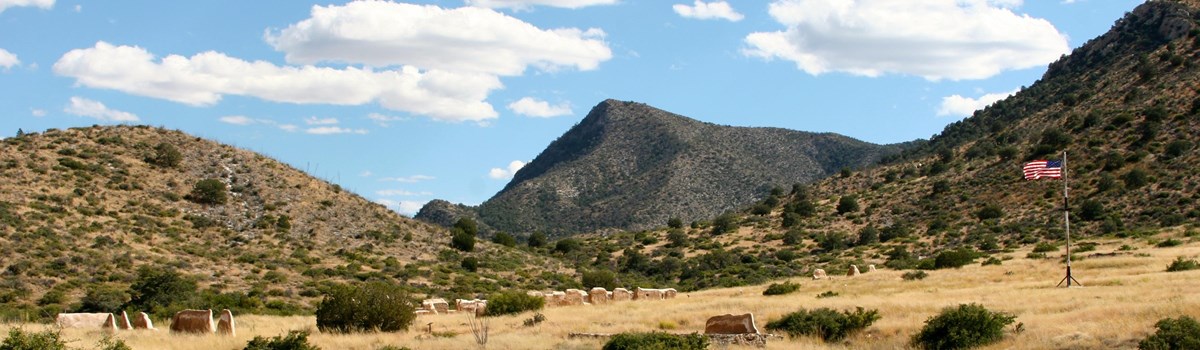
The Battle of Apache Pass led to building Fort Bowie to protect both the pass and Apache Spring. Soldiers from the 5th California Volunteer Infantry started building it on July 28, 1862. Set on a hill overlooking the spring, it was named for regimental commander Col. George Washington Bowie. Completed in under three weeks, the fort was more temporary camp than permanent post—13 tents surrounded by irregular stone breastworks thrown up at key positions atop the hill. As winter loomed, crude stone and adobe huts replaced the tents. One officer called them "mere hovels" that leaked rain like "a sieve." In 1868 a less primitive Fort Bowie was built on a plateau 300 yards to the southeast. Substantial adobe barracks, a row of houses for officers, corrals, storehouses, a post trader's store, and a hospital soon occupied the four sides of the sloping parade ground. More buildings were added over the years. When it was abandoned in 1894 Fort Bowie was a modern post of about 38 structures. These are the ruins you see here today.
Between 1862 and 1886, Fort Bowie was the nerve center for military campaigns against hostile Chiricahua Apaches led first by Cochise and then by Geronimo. Cochise finally made peace in 1872, and he and his people were given a 3,000-square-mile reservation in southeastern Arizona that included their traditional homeland.
After Cochise died of natural causes in 1874, Indian agent Tom Jeffords tried to maintain order, but young Apaches grew discontented with reservation conditions. Their escape fueled growing distrust between Indians and settlers. In 1876, to impose more rigid control, the federal government abolished the Chiricahua Reservation, ordering everyone moved to the San Carlos Reservation in the hot, barren, and disease-ridden Gila River Valley. But several bands led by Geronimo and others fled to northern Mexico's Sierra Madre and began to terrorize the border region. For the next 10 years most of these "renegades" would be captured and returned to San Carlos. But, with reservation restraints and deplorable conditions, many escaped again, some more than once. In the last outbreak in May 1885 Geronimo led 134 Chiricahuas back into Mexico. They were pursued by soldiers and Apache scouts under Brig. Gen. George Crook and then under Brig. Gen. Nelson A. Miles.
After their final surrender in September 1886, Geronimo and his remaining followers were brought to Fort Bowie, assembled on the parade ground, and taken by wagons to the railroad for the long journey to exile in Florida. Geronimo's defeat ended both the Apache Wars and Fort Bowie's military usefulness. The fort was an active post for eight more years, finally closing on October 17, 1894, when the last troops were withdrawn.
Butterfield Overland Mail
"Remember, boys, nothing on God's earth must stop the United States mail!" That's what John Butterfield told his Overland Mail stage drivers when he started his semi-weekly, 24-day mail service to California on September 15, 1858. Butterfield's Overland Mail Company started with 2,000 employees, over 250 coaches and several hundred wagons, 1,800 horses and mules, and 240 stage stations spaced along its 2,800-mile route.
The federal government paid the company $600,000 per year to carry the mail. The Overland Mail route began at Memphis, Tennessee, and St. Louis, Missouri, joined at Fort Smith, Arkansas, then went to El Paso, Texas, across southern New Mexico and Arizona to Fort Yuma, and up California's central valley to San Francisco.
In its three-year history, the Overland Mail was attacked only once by Apaches and was late reaching the end of the line only three times.
The Bascom Affair
In January 1861 a band of Apaches raided the ranch of John Ward, stole some stock, and kidnapped the son of a Mexican woman who lived with Ward. Ward wrongly believed that Cochise and his Chiricahuas were responsible and demanded that the military authorities confront Cochise, recover his stock, and secure the boy's return. In February the Army sent Lt. George Bascom and 54 men into Apache Pass.
After setting up camp about a mile from the Butterfield stage station, Bascom lured Cochise into his tent and threatened to hold him hostage until Ward's property and the boy were returned. Furious and insulted, Cochise slashed through the tent wall and eluded the soldiers outside. Sporadic fighting between Cochise's warriors and Army troops bloodied Apache Pass for the next two weeks.
The Bascom affair sparked open warfare between whites and Apaches that raged intermittently for the next 10 years.
Cochise (1824?-74) was not overly hostile to whites until 1861, when false accusations of theft and kidnapping sparked 10 years of death and destruction in southern Arizona.
George Crook (1829-90), West Point graduate and Civil War veteran, came to Fort Bowie in 1871 to fight against Cochise. He returned 11 years later to fight against Geronimo.
Crook was one of the few professional military men who saw Indians as worthy adversaries. He advocated granting them full civil rights and all the privileges of citizenship.
Nelson A. Miles (1839-1925) had a renowned military career from the Civil War to the 1900s. He served mostly in the West, fighting Crazy Horse, capturing Chief Joseph of the Nez Perce, and forcing Sitting Bull's surrender.
Replacing Crook, Miles engineered Geronimo's surrender in 1886 and suppressed the Sioux's Ghost Dance in 1890-91 in the last of the nation's major Indian wars.
Geronimo (1829-1909) was the most famous Apache leader. He was not a chief, but many tribe members turned to him for leadership when they were moved to the San Carlos Reservation in 1876.
For the next 10 years, he alternately stayed peacefully on the reservation and waged war against the settlers. His final surrender ended the Apache Wars.
Visiting the Fort Area
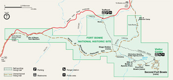 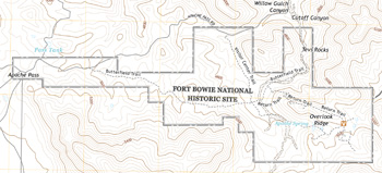 (click for larger maps) |
A Walk into History
The original route into Fort Bowie was a wagon road built by soldiers who
garrisoned the post. For most visitors today, access to the fort is via a
1.5-mile hiking trail of moderate difficulty.
Begin at the trailhead on Apache Pass Road and pass by historic features including the ruins of the Butterfield Stage Station, post cemetery, Apache Spring, and site of the first Fort Bowie. Plan at least two hours for this 3-mile roundtrip walk and visit.
The park, including trails and ruins areas, is open daily from sunrise to sunset. A visitor center has exhibits and a Western National Parks Association store. Visitor center hours vary; check the park website for current schedules.
The Natural Setting
The hills around Fort Bowie lie in the Upper Sonoran life zone and contain
several biotic communities. Desert grasslands dominate the lower slopes. The
chaparral is characterized by tough evergreens, which can form dense thickets of
silk tassel, manzanita, and mountain mahogany.
Oak, juniper, and pinyon pine grow on the higher slopes. Large trees, like willow, walnut, and cottonwood, typically grow along sandy drainages.
Following good winter rains, spring and summer wildflowers brighten hillsides—bladder pod, desert baileya, alionia, and globe mallow. You may see deer, gray fox, coyote, cougar, bobcat, coati, javelina, snakes, lizards, and many bird species.
For a Safe Visit
Fort Bowie's 5,000-foot elevation may require some getting used to. Drinking
water is available only at the visitor center. While hiking, carry water and
wear sun protection—there is very little shade and summer temperatures may
exceed 100°F. Avoid hiking when lightning threatens. Summer rainstorms can
quickly flood washes. Wait out high water. Watch for rattlesnakes.
Drug smuggling and illegal entry can occur this close to the US-Mexico border. Always be aware of your surroundings. Do not travel alone in remote areas. Report suspicious behavior to park staff or call 911.
Protect the Park
All natural and cultural features are protected by federal law. Hunting for,
collecting, or destroying plants, animals, structures, or historic objects is
prohibited. • For firearms regulations check the park website. • Metal
detectors and digging tools are not allowed in the park. • Do not climb on
the fragile walls or mounds. Stay on trails. • Wheeled vehicles must stay
on established roads. • Pets must be leashed at all times.
Camping and Services
There are no camping facilities in the park. Motels, stores, trailer parks,
campgrounds, and other services can be found in nearby Willcox and Bowie.
Chiricahua National Monument has a campground.
Accessibility
We strive to make our facilities, services, and programs accessible to all. For
more information go to a visitor center, ask a ranger, call, or check our
website. If you are unable to hike the 3-mile roundtrip trail, check the park
website or call for alternate access directions.
Getting Here
From Willcox on I-10 drive 22 miles south on AZ 186 to the graded dirt road
leading east into Apache Pass.
From the town of Bowie on I-10, drive south 12 miles on the partly paved road leading directly into Apache Pass.
Do not attempt to cross flooded washes. Wait until the flooding subsides before you cross.
Source: NPS Brochure (2018)
|
Establishment Fort Bowie National Historic Site — August 30, 1964 |
For More Information Please Visit The  OFFICIAL NPS WEBSITE |
Documents
A Boy Once Names Felix (Karen Weston Gonzales, undated)
A Clash of Cultures: Fort Bowie and the Chiricahua Apaches (Robert M. Utley, 1977)
A Clash of Cultures: Fort Bowie and the Chiricahua Apaches (Robert M. Utley, 1977, reprint 1984)
An Annotated List of Vascular Plants of the Chiricahua Mountains Cooperative National Park Resources Studies Unit Special Report No. 12 (Peter S. Bennett, R. Roy Johnson and Michael R. Kunzmann, October 1996)
Acoustical Monitoring 2010, Fort Bowie National Historic Site NPS Natural Resource Report NPS/NRSS/NRR-2014/874 (Noah Schulz, Cynthia Lee and John MacDonald, November 2014)
Archeological Findings of the Battle of Apache Pass (Non-Sensitive Version), Fort Bowie National Historic Site NPS Natural Resource Report NPS/FOBO/NRR-2016/1361 (Larry Ludwig, December 2016)
Archeological Sample Survey of the Florida Mountains, Luna County, New Mexico (Charles M. Haecker, August 2002)
Arizona Explorer Junior Ranger (Date Unknown)
Cattle Grazing in the National Parks: Historical Development and History of Management in Three Southern Arizona Parks (©Robin Lathrop Pinto, PhD Thesis University of Arizona, May 22, 2014)
Cultural Landscapes Inventory (Robin L. Pinto, Irene Herring and P. Annie Kirk, December 2000)
Ethnographic Overview and Assessment of Chiricahua National Monument and Fort Bowie National Historic Site (Scott Rushforth, July 2010)
Final Environmental assessment, Master Plan Fort Bowie (November 1975)
Final Master Plan, Fort Bowie National Historic Site, Arizona (November 1975)
Five Year Summary of Wildlife Camera Trap Monitoring across Three Parks: A systematic approach to monitoring wildlife NPS Natural Resource Report NPS/CHIR/NRR-2015/1069 (Amanda Selnick, Jason Mateljak and Thomas Athens, October 2015)
Fort Bowie National Historic Site and Chiricahua National Monument Visitor Survey Cooperative National Park Resources Studies Unit Special Report No. 6 (Ervin H. Zube, Christina Kennedy and David Simcox, June 1987)
Foundation Document, Fort Bowie National Historic Site, Arizona (January 2016)
Foundation Document Overview, Fort Bowie National Historic Site, Arizona (May 2016)
Geologic Resources Inventory Report, Fort Bowie National Historic Site NPS Natural Resource Report NPS/NRPC/GRD/NRR-2011/443 (J. Graham, September 2011)
Historical Report on Fort Bowie, Arizona (Robert M. Utley, January 1958)
Historic Structure Report, Historical Data Section — Fort Bowie: Its Physical Evolution, 1862-1894, Fort Bowie National Historic Site, Arizona (Jerome A. Greene, July 1980)
Junior Arizona Archeologist (2016)
Miss Daisy's Silver Concho (Karen Gonzales, undated)
National Register of Historic Places Nomination Forms
Apache Pass and Fort Bowie (Albert H. Schroeder, December 13, 1961)
Old Fort Bowie (Robert J. Gamer, April 8, 1970)
Park Newspaper (The Explorers: A Visitor's Guide to the Southwest Arizona Parks): 2012 • 2017
Rocks in the Chiricahua National Monument and the Fort Bowie National Historic Site Arizona Geological Survey Down-To-Earth 11 (John V. Bezy, 2001; ©Arizona Geological Survey)
Springs, Seeps and Tinajas Monitoring Protocol: Chihuahuan and Sonoran Desert Networks NPS Natural Resource Report NPS/SODN/NRR-2018/1796 (Cheryl McIntyre, Kirsten Gallo, Evan Gwilliam, J. Andrew Hubbard, Julie Christian, Kristen Bonebrake, Greg Goodrum, Megan Podolinsky, Laura Palacios, Benjamin Cooper and Mark Isley, November 2018)
Status of Climate and Water Resources at Chiricahua National Monument, Coronado National Memorial, and Fort Bowie National Historic Site: Water Year 2019 NPS Natural Resource Report NPS/SODN/NRR—2022/2378 (Kara Raymond, Laura Palacios, Andy Hubbard, Cheryl McIntyre and Evan Gwilliam, May 2022)
Survey of the Vertebrate Fauna of Fort Bowie National Historic Site Cooperative National Park Resources Studies Unit Technical Report No. 2 (E. Lendell Cockrum, Stephen M. Russell and Charles H. Lowe, October 26, 1976)
Terrestrial Vegetation and Soils Monitoring at Fort Bowie National Historic Site: 2008 Status Report NPS Natural Resource Technical Report NPS/SODN/NRTR-2010/368 (J. Andrews Hubbard, Sarah E. Studd and Cheryl McIntyre, September 2010)
The Past and Future of Fort Bowie National Historic Site: An Administrative History (Robin L. Pinto, September 26, 2012)
Vegetation and Flora of Fort Bowie National Historic Site, Arizona NPS Technical Report NPS/WRUA/NRTR-92/43 (Peter L. Warren, Marina S. Hoy and Wilton E. Hoy, March 1992)
Vegetation, Inventory, Mapping, and Classification Report, Fort Bowie National Historic Site NPS Natural Resource Report NPS/SODN/NRR-2013/673 (Sarah Studd, Elizabeth Fallon, Laura Crumbacher, Sam Drake and Miguel Villarreal, June 2013)
Visitor Survey, Fort Bowie National Historic Site and Chiricahua National Monument Special Report No. 6 (Ervin H. Zube, Christina Kennedy and David Simcox, June 1987)
fobo/index.htm
Last Updated: 01-Jan-2025