|
Fort Frederica National Monument Georgia |
|
 NPS photo | |
A Military Town on the Colonial Georgia Frontier
Defending Utopia
The ruins of old Frederica recall the struggle for empire in the Southeast in the 1700s. Ancient rivals Spain and Great Britain, the main contenders, both claimed the land between St. Augustine and Charleston. But Spain was a waning power in this part of North America while Great Britain was building a vast empire from Maine to Carolina. As a southern frontier buffer, Britain planted the Georgia colony—the last of the original 13 and the first since Quakers founded Pennsylvania half a century earlier—in the territory below Carolina.
The colony sprang as much from a spirit of benevolence as from the realities of imperial politics. Like the Quaker venture, Georgia was an experiment in idealism. In the 1720s England felt a wave of sentiment to remedy the plight of thousands of poor people drifting without jobs or languishing in debtors' jail. To salvage these "worthy poor," prominent English citizens—among them James Oglethorpe, a soldier and politician concerned with the welfare of both the poor and the empire—petitioned the Crown for a land grant south of the Savannah River. The government welcomed the enterprise as a way to hold the Spanish in check and relieve social distress at home.
In 1732 King George II granted to a board of trustees all the land between the Savannah and Altamaha rivers and west from their headwaters to the Pacific—a tract larger than Britain. British of all classes rallied to the idea of a new Utopia in the American wilderness. Money poured in, public and private, and the first shipload of 114 people set sail led by Oglethorpe. Reaching Georgia in January 1733, they traveled up the Savannah River 18 miles to their new home.
Spurred by Oglethorpe's energy—he was everywhere "building the Town, Keeping peace, laying out land, Supplying the Stores with provision, encouraging the faint hearted &c"—an orderly town, Savannah, rose on the bluffs.
James Edward Ogelthorpe
A man of vision, compassion, and vast energy, Oglethorpe founded and led the Georgia colony for its first decade. Under his guidance, the colony welcomed immigrants of diverse religious views and national origins, banned slavery and rum, and successfully resisted Spanish attack.
Settlement was one of Oglethorpe's purposes; another was defense against the Spanish. In 1734 he sailed down the coast to find strategic points to fortify. He found one on a sea island just below the mouth of the Altamaha. This was St. Simons, an island thick with live oaks draped in moss, with good water and a fertile upland. Two years later he returned with the first settlers, 44 men (mostly skilled workers) and 72 women and children, and laid out a military town on a bluff overlooking a sharp bend in the inland passage up the coast. He named the town for Frederick, the king's only son. It came to be Oglethorpe's favorite town in Georgia.
The settlers' first task was to build a fort. Under Oglethorpe's direction they raised an earthen work that reflected classical ideas of the 1600s French military engineer Vauban. Over the years Oglethorpe remade this work and the town into a formidable position. Frederica is defended, wrote a visitor in 1745, "by a pretty strong Fort of Tappy, which has several 18 Pounders mounted on a Ravelin in its Front, and commands the River both upwards and downwards; and is surrounded by a quadrangular Rampart, with 4 bastions, of Earth well stockaded and turfed, and a palisaded Ditch."
Behind the fort, on a field planted in corn by the Indians, Oglethorpe laid out 84 lots, most 60 by 90 feet. Each family received 3 lot for building and 50 country acres for crops. The first dwellings, palmetto huts, were eventually replaced by houses built of wood, tabby (a crude concrete made of burnt oyster shells), and brick in the Georgian style. Orange trees shaded the main road, 75-foot-wide Broad Street, which ran from the fort to the town gates. Frederica's artisans included a blacksmith—his shop was in the fort's northeast bastion—wheelwright, and public baker Oglethorpe brought over as an indentured servant.
Aside from lacking a church spire, 1740s Frederica might have passed for an English midlands village. The population reached about 500, and the town took on an air of permanency. Tradespeople and skilled workers prospered. Farmers cultivated crops with their own hands in the nearby fields—slavery was banned in the colony. Most families supplemented their diet with the region's abundant wildlife, shooting almost anything that moved.
The Battle of Bloody Marsh
Having repelled Oglethorpe at the gates of St. Augustine, the Spanish gathered an armada and in June 1742 sailed north to invade the English colonies and regain lands they considered theirs. Oglethorpe faced the threat without support from the Carolinians or London. Rounding up Indians, militia, and Scottish Highlanders to go with his regulars, the resourceful commander tirelessly prepared his defenses. He had about 900 men but faced twice that number.
Spanish commander Manuel de Montiano, governor of Florida, sought to destroy Frederica and lay waste the coast as far north as Port Royal, S.C. After taking that town, he would strike at the English plantation system by freeing slaves in the nearby countryside.
In early July his ships ran by the guns of Fort St. Simons and landed troops a few miles up the inland passage. Outflanked, Oglethorpe pulled back to Frederica. On July 7, some 200 Spaniards advanced up the military road that connected the forts. Oglethorpe routed this column with a fierce attack.
Learning of this repulse, Montiano sent several hundred men forward to cover the retreat, but his troops ran into a British ambush posted "in a Wood with a large . . . Meadow in their Front."
Legend has it the marsh ran red with blood as British musket fire routed this force, too. Although casualties were relatively light, within the week Montiano's army quit St. Simons and returned to Florida, ending the last Spanish threat to the Georgia colony.
War and Decline
Spain saw the Georgia settlements as a threat to its interests in Florida. Spoiling for a fight, Oglethorpe returned to England in 1737 to raise troops. In 1738 he came back at the head of a 630-man regiment of British regulars, the 42d Regiment of Foot (Oglethorpe's); a few hundred troops from Gibraltar; and most of the privates of a standing regiment in England, the 25th Foot.
The regiment's eight companies of infantry and one of grenadiers carried the long musket, the famous Brown Bess, and infantry swords. The elite grenade-carrying grenadiers were chosen for their size and combat skill. Oglethorpe mostly garrisoned his troops at Frederica and a new fort, Fort St. Simons, on the south end of the island.
In 1739 Britain and Spain went to war over the slave trade. Fighting ranged across the Caribbean and up the Georgia coast to Frederica. Expecting a Spanish attack, Oglethorpe enclosed the town with an earthen wall and 10-foot-wide palisaded moat fed by the river. In early 1740 the aggressive Oglethorpe set out to capture St. Augustine. With 900 troops and 1,100 Indian allies, he laid siege to the Spanish town but could not breach its defenses. By mid-summer, his plans awry, a frustrated Oglethorpe was back in Frederica.
The Spanish now had the initiative. With 50 sailing vessels and 2,000 troops they threatened 1742. A column of men advanced to within sight of Frederica but the British beat them back. This was the high point of the Spanish invasion. Later that day, Oglethorpe's men ambushed another column at Bloody Marsh for a decisive victory. Within a week the dispirited Spanish left the island, and Oglethorpe proclaimed a day of thanksgiving for this deliverance.
Born of war, Frederica expired with the coming of peace. After one more foray against Spanish Florida, Oglethorpe sailed to England for the last time in 1743. His regiment was disbanded in 1749. Absent several hundred soldiers' money, the town and its shopkeepers and tradespeople could not prosper. A visitor in 1755 described Frederica as "houses without inhabitants, barracks without soldiers, guns without carriages, and streets overgrown with weeds." The town hung on a few more years, and even survived a 1758 fire, but it had outlived its purpose and fell into ruin.
Oglethorpe's Town
Now lost to time and the wandering river, Frederica barely resembles the military town that once flourished here. From 1736 to 1749 the fort and its regimental garrison were the hub of British military operations on Georgia's frontier.
Fort Frederica in 1742 Oglethorpe's troops defeated Spanish troops at Bloody Marsh. Like Savannah, Frederica was a planned town, built by the "worthy poor" who Oglethorpe and fellow trustees transplanted here. It was a thoroughly English town of spacious streets and substantial houses in the Georgian style. An admiring traveler described the scene for London Magazine in 1745: "Some houses are built entirely of brick, some of brick and wood, some few of tabby work; but most of the meaner sort of wood only."
Of all his settlements in Georgia, Oglethorpe liked this one best. He enjoyed the town's military air and was proud of his troops, who "made as fine an appearance upon the parade as any Regiment in the King's service."
His own home, a cottage amid a grove of live oaks with a garden and orchard nearby, seemed to a visitor like "a neat country village where the consequences of all the various industries of an European farm may be seen."
Touring the Park
A good way to see Frederica is to stroll through the town site.
A military road connected Frederica with Fort St. Simons, six miles away or the south end of the island. More like a path cut through a forest than a road, it crossed marshy ground on a causeway. British troops marched down this path to battle invading Spanish troops in 1742.
The town gate controlled land access to Frederica. Soldiers routinely stood guard here. Outside the gate, townspeople traded with local Creek and Yuchi Indians.
Broad Street divided the town into north and south wards. The first settlers planted orange trees along this street, thinking that in time they would have "a very pretty effect on the view, and render... the town pleasingly shady."
The three-stony Calwell house was the best dwelling in town. John Calwell made candles and soap here and his wife kept a shop.
Two prominent families occupied the Hawkins-Davison houses. Thomas Hawkins, surgeon and apothecary, built the west half; Samuel Davison, tavernkeep and town constable, built the east half. They ran their businesses here.
A tabby fort guarded the twisting water approach to the town. The fort was square with bastions on each corner and separated from the town by a palisade and moat. Inside were a magazine for guns and ammunition, officers' quarters, storehouses, and a forge. A spur battery, lost long ago to the river, mounted six or seven cannon.
The barracks housed most of the several hundred soldiers garrisoned at Frederica. Other soldiers lived nearby in palmetto-thatched huts.
The northeast bastion is a remnant of works that Oglethorpe built in 1739 when an invasion threatened. He fortified the town with an earthen rampart, a moat six to eight feet deep, and a cedar palisade 10 feet high.
The burying ground, of which little is known, lay just east of town.
For a Safe Visit
• Lightning storms are dangerous. Seek shelter in the visitor
center or in your car but not under trees. • Watch your step near
the riverbank; the water is swift and deep. • Don't climb on the
fort or cannon. •• Parents should keep a careful watch on small
children.
Related Sites
Visit other nearby parks to learn more about colonial Georgia. Fort King
George State Historic Site in Darien reconstructs the first British
outpost in Georgia. It protected the Altamaha River and inner passage
from French and Spanish attack from 1721 to 1736. Wormsloe State
Historic Site on the Isle of Hope near Savannah preserves ruins of a
plantation built 1739-45. Here stood the fortified home of Noble Jones,
one of Georgia's first settlers. At Fort Morris State Historic Site,
south of Savannah, are remains of a once-prosperous port city and an
earthen work captured by the British in the Revolutionary War.
Several National Park Service sites in Florida figure in Frederica's story. Timucuan Ecological and Historic Preserve, in Jacksonville, preserves areas relating to the British occupation of Florida from 1763 to 1784. Castillo de San Marcos and Fort Matanzas national monuments in St. Augustine remind us that Spain also claimed the land on which Frederica stood and was willing to fight for it.
Frederica Today
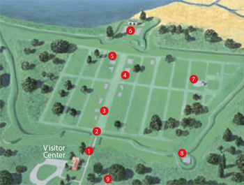 (click for larger map) |
On St. Simons Island 12 miles from Brunswick, Ga., the park can be reached via U.S. 17 and the FJ Torras (Brunswick-St. Simons) Causeway. Hours: 8:30 am to 5 pm. No camping facilities.
Bloody Marsh Battle Site is a detached park unit six miles south of Frederica. Nearby are the remains of Fort St. Simons, constructed on the island's south end, and the old military road that connected the fort with Frederica. Gully Hole Creek, scene of an earlier skirmish, lies half a mile east of the visitor center. The site is marked by a state historic plaque.
Help Protect Frederica
Fort Frederica is an archeological site and the remains here are
fragile. Please do not walk on or disturb any surviving foundations,
brick or tabby.
Notify a park ranger if you see exposed artifacts so the ranger can collect and document them to help complete the picture of life here in colonial times.
Federal law prohibits digging or using metal detectors within the park.
Source: NPS Brochure (2009)
|
Establishment Fort Frederica National Monument — May 26, 1936 |
For More Information Please Visit The  OFFICIAL NPS WEBSITE |
Documents
An Ecological Survey of the Coastal Region of Georgia (HTML edition) (A. Sydney Johnson, Hilburn O. Hillestad, Sheryl Fanning Shanholtzer and G. Frederick Shanholtzer, 1974)
Anuran Community Monitoring at Fort Frederica National Monument: 2014 Data Summary NPS Natural Resource Data Series NPS/SECN/NRDS-2015/980 (Brianna D. Smrekar and Michael W. Byrne, October 2015)
Assessment of Estuarine Water Quality at Fort Frederica National Monument, 2008 NPS Natural Resource Data Series NPS/SECN/NRDS-2010/114 (M. Brian Gregory, Joe DeVivo, Phillip H. Flournoy and Katy Austin Smith, November 2010)
Coastal Hazards & Sea-Level Rise Asset Vulnerability Assessment for Fort Frederica National Monument: Summary of Results NPS 369/186747 (K.M. Peek, H.L. Thompson, B.R. Tormey and R.S. Young, November 2022)
Fort Frederica Historic Site Report (Albert C. Manucy w/C.R. Vinten and J.C. Harrington, 1945)
Foundation Document, Fort Frederica National Monument, Georgia (September 2016)
Foundation Document Overview, Fort Frederica National Monument, Georgia (September 2016)
Historic Site Report: Fort Frederica (Albert C. Manucy, C.R. Vinten and J.C. Harrington, 1945)
Junior Ranger Adventure Book: Open the Door to Explore: Fort Frederica National Monument (Date Unknown; for reference purposes only)
Landbird Community Monitoring at Fort Frederica National Monument, 2010 NPS Natural Resource Data Series NPS/SECN/NRDS-2011/193 (Michael W. Byrne, Joe C. DeVivo and Brent A. Blankley, August 2011)
Landbird Community Monitoring at Fort Frederica National Monument: 2014 Data Summary NPS Natural Resource Data Series NPS/SECN/NRDS-2016/1058 (Michael W. Byrne and Elizabeth A. Kurimo-Beechuk, September 2016)
Masonry Forts of the National Park Service: Special History Study (F. Ross Holland, Jr. and Russell Jones, August 1973)
National Register of Historic Places Nomination Form
Fort Frederica National Monument (Nancy Aiken, December 5, 1974)
Natural Resource Condition Assessment, Fort Frederica National Monument NPS Natural Resource Report NPS/NRSS/WRD/NRR-2012/516 (Jessica L. Dorr, David M. Palmer and Rebecca M. Schneider, April 2012)
Park Newspaper (Frederica Almanack)
2005: Winter • Spring • Summer • Fall
2006: Winter • Spring • Summer • Fall
2007: Winter • Spring • Summer • Fall
2008: Winter • Spring • Summer • Fall
2009: Winter • Spring • Summer
2010: Fall
Summary of Amphibian Community Monitoring at Fort Frederica National Monument, 2009 NPS Natural Resource Data Series NPS/SECN/NRDS-2010/097 (Michael W. Byrne, Laura M. Elston, Briana D. Smrekar and Piper A. Bazemore, October 2010)
Terrestrial Vegetation Monitoring at Fort Frederica National Monument: 2020 Data Summary NPS Natural Resource Data Series NPS/SECN/NRDS-2022/1372 (M. Forbes Boyle and Elizabeth Rico, October 2022)
Theme IV: Spanish Exploration and Settlement. National Historic Landmark Theme Studies (April 1959)
The Fort at Frederica Notes in Anthropology Vol. 5, Florida State University (Albert C. Manucy, 1962)
The Vegetation History of Fort Frederica, Saint Simons Island, Georgia NPS Research/Resources Management Report SER-66 (Susan Bratton, 1983)
Vegetation Community Monitoring at Fort Frederica National Monument, 2009 NPS Natural Resource Data Series NPS/SECN/NRDS-2012/251 (Michael W. Byrne, Sarah L. Corbett and Joseph C. DeVivo, February 2012)
Vegetation Mapping at Fort Frederica National Monument NPS Natural Resource Report NPS/FOFR/NRR-2013/684 (Rachel H. McManamay, Anthony C. Curtis and Sarah L. Corbett, July 2013)
fofr/index.htm
Last Updated: 01-Jan-2025