|
Geological Survey Bulletin 1021-I
Geology of Devils Tower National Monument, Wyoming |
INTRODUCTION
Devils Tower, a mass of bare rock that rises abruptly from the surrounding grasslands and pine forests, is one of the most conspicuous geologic features of the Black Hills region. Because of its scenic beauty and scientific interest, President Theodore Roosevelt in 1906 established Devils Tower and a small surrounding area as the first National Monument.
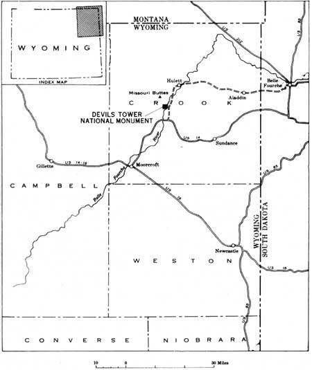
The Devils Tower National Monument covers an area of about 2 square miles near the center of Crook County in northeastern Wyoming (fig. 52). A paved road from the entrance of the National Monument goes south 7 miles to join U. S. Highway 14 at a point 29 miles northwest of Sundance, Wyo., and 33 miles northeast of Moorcroft, Wyo. The entrance to the National Monument may also be reached by a road (paved in Wyoming) that goes northeastward from the entrance, via Hulett and Aladdin, Wyo., to Belle Fourche, S. Dak., a distance of about 54 miles, where it joins U. S. Highways 212 and 85.

|
| FIGURE 52.—Index map showing location of Devils Tower National Monument. (click on image for an enlargement in a new window) |
Public campgrounds and a natural history museum are maintained by the National Park Service at the base of the Tower about 3 miles by paved road from the Monument entrance.
The geology of the Devils Tower National Monument was mapped during the summer of 1954 by the U. S. Geological Survey in collaboration with the National Park Service. The work was part of a study of the geology of the northern and western parts of the Black Hills region conducted by the Survey on behalf of the Division of Raw Materials of the U. S. Atomic Energy Commission. The author wishes to acknowledge the assistance of the National Park Service and, in particular, Mr. Raymond McIntyre, Superintendent of Devils Tower National Monument.
| <<< Previous | <<< Contents >>> | Next >>> |
bul/1021-I/intro.htm
Last Updated: 01-Mar-2005