
|
Geological Survey Bulletin 1393
The Geologic Story of Arches National Park |
A TRIP THROUGH THE PARK
(continued)

Devils Garden
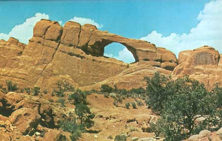
Turning left (northwest) at the intersection with the paved park road, we enter Devils Garden—another large maze of towering red fins separated by narrow slots, which resembles the Fiery Furnace. After a third of a mile, we reach stop 24 and walk 100 feet or more to the north for a good view of Skyline Arch (fig. 48). This arch is very appropriately named, as it forms the skyline viewed either from the road on the south or from the campground on the north, from points south of the amphitheater. Less well known is the fact that Skyline Arch is clearly visible to the naked eye or through binoculars from stretches of Highway I—70 (or old U.S. Highways 6 and 50) about 11 miles to the north. Most arches and other erosion forms do not change appearance much from day to day or year to year, but some, like "Baby Arch" (fig. 15), show evidence of relatively recent origin. In November 1940 (Abbey, 1971, p. 42) Skyline Arch suddenly doubled in size by the fall of a large rock that occupied what is now the northwest half of the arch. Photographs taken before and after this event appear on pages 24 and 25 of the road guide and also in the museum at the Visitor Center.
|
| SKYLINE ARCH, viewed north from point about 100 feet north of stop 24, in Slick Rock Member. Although fins are vertical, note that the strata seem to dip about 15° to the right, although the actual dip is to the northeast. (See fig. 50.) (Fig. 48) |
Another half mile brings us to a one-way (to right) loop at the end of the park road. Just beyond the beginning of the loop is a parking lot and very attractive picnic area containing several picnic tables shaded by piñon pines at the foot of a towering red fin of the Slick Rock Member. Just north of this picnic ground, a paved side road leads eastward into a truly beautiful, well-equipped campground comprising both back-in and drive-through campsites for trailers, campers, or tents; three pairs of modern restrooms, hydrants, and drinking fountains; and an amphitheater, where illustrated campfire talks are given nightly during the summer. The east end of the campground is shown in figure 49.

|
| CAMPGROUND IN DEVILS GARDEN, viewed northwestward across turn-around at southeastern end. (Fig. 49) |
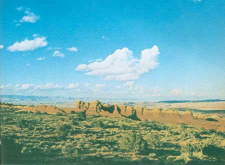
Devils Garden in general and the campground in particular are on the crest of a ridge separating Salt Valley to the southwest from the Sagers Wash syncline to the north east, which lies north of Yellow Cat Flat and north of the area shown in figure 1. From the higher parts of the campground striking views are to be had toward the north and northeast, particularly late in the afternoon, as shown in figure 50.
|
| VIEW NORTH FROM CAMPGROUND, in late afternoon. Reddish Slick Rock Member capped by light-colored Moab Member are seen dipping northeastward toward Sagers Wash syncline. Book Cliffs, north of Thompson, are 16 miles north on left skyline. (Fig. 50) |
In about the middle of the one-way loop at the end of the park road is a well that supplies water to the campground from early in the spring until the return of freezing weather late in the fall. The well, which was drilled in 1962 to a depth of 900 feet, obtains a small amount of water from the Wingate Sandstone. No water was found in the overlying Navajo and Entrada Sandstones because of the pronounced dip of the rocks toward the northeast, which allows any water in these rocks to drain northeast ward (Ted Arnow, written commun., 1963). Water from this well is pumped to a steel tank in a high part of the campground, whence it flows by gravity to the three sets of restrooms.
At the northwest end of the one-way loop is a large parking area for use by people hiking the Devils Garden trail. This trail leads to seven of the most interesting arches in the park, all of which are in the Slick Rock Member, and there are many more farther to the northwest. The approximate distances to the seven arches are given in the paragraphs that follow. The trail is paved for about 1 mile as far as Landscape Arch (fig. 53), but from there to Double O Arch (fig. 56) the trail is primitive, and the Park Service recommends rubber soles as part of the trail is on bare sandstone. For these reasons, many visitors hike only as far as Landscape Arch.
Much of the trail, particularly the first part, lies in a narrow slot between fins of the Slick Rock Member, as shown in figure 51. After about half a mile, a side trail to the north leads to a Y, the right-hand fork of which goes to Tunnel Arch (fig. 14). The left-hand fork leads to Pine Tree Arch, obviously named for the piñon pine framed by this arch (fig. 52).

|
| SOUTHEASTERN PART OF DEVILS GARDEN TRAIL, viewed north westward. Narrow slot between fins of Slick Rock Member indicates local spacing of joints. (Fig. 51) |

|
| PINE TREE ARCH, viewed northeastward. Opening is 46 feet wide and 48 feet high. Fin is 30 feet thick. (Fig. 52) |
At the end of the improved part of the trail, we reach Landscape Arch (fig. 53), claimed by the Park Service to be the longest known natural arch in the world. According to Ouellette (1958) it is 291 feet long and 118 feet high, but Professor Stevens' measurements indicate it to be 287 feet long and 106 feet high. At its thinnest point on the right, the span is only 11 feet wide and 11 feet thick. In 1958 three young men made what was claimed to be the second known ascent of Landscape Arch, using ropes and other climbing gear, after which they walked across (Ouellette, 1958). This crossing was made with the permission of a park ranger, but such permission is no longer given, for the safety of both the arch and of would-be climbers.

|
| LANDSCAPE ARCH, viewed southwestward from near end of improved part of Devils Garden trail. Note that ground beneath arch is covered by slope wash and near the middle with what appears to be a small landslide. Slick Rock Member here is more nearly buff than salmon colored, because of a smaller content of iron oxide. Fresh breaks and angular blocks of stone at right abutment indicate relatively recent rock falls. See text for size. (Fig. 53) |
Wall Arch is about a quarter of a mile beyond the end of the improved part of the trail, and another three-fourths mile brings us to Navajo Arch (fig. 54) and Partition Arch (fig. 55). A distant view of Partition Arch may be had just before reaching Landscape Arch. Part of the remaining trail to Double O Arch (fig. 56) is on the top of a low sandstone fin, in part between somewhat higher fins and in part above lower slots.

|
| NAVAJO ARCH, viewed northeastward from a branch of Devils Garden trail. One of few arches having a flat soil-covered floor. Opening is 40-1/2 feet wide. Photograph by National Park Service. (Fig. 54) |

|
| PARTITION ARCH, viewed southwestward from near Devils Garden trail. Arch frames part of south wall of Salt Valley and, on skyline, mesas south of Moab Valley. Opening is 27-1/2 feet wide and 26 feet high. A smaller opening to the right measures 8-1/2 feet wide and 8 feet high. Photograph by Dawn E. Reed. (Fig. 55) |
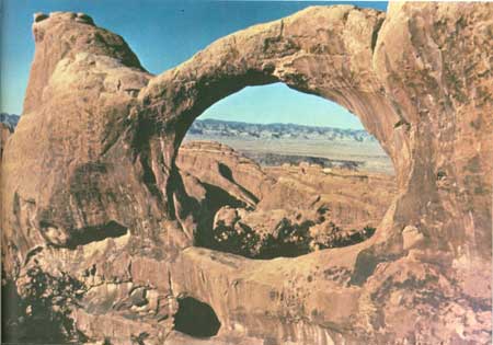
Beautiful Double O Arch (fig. 56) is at the end of the Devils Garden trail about 2-1/2 miles northwest of the trail-head. About half a mile northwest of the trail's end is a prominent landmark called Dark Angel (fig. 57), which is visible in figure 12 and from the unimproved road in Salt Valley.
|
| DOUBLE O ARCH, viewed about north from northwest end of Devils Garden trail. Large opening is 71 feet wide and 45 feet high; small one at lower left is 21 feet wide and 11 feet high. Span of large opening is 11 feet wide and 6 feet thick. Arch frames a part of the Book Cliffs about 14 miles to the north. Photograph by Hildegard Hamilton, Flagstaff, Ariz. (Fig. 56) |

|
| DARK ANGEL, a shaft of the Slick Rock Member that is an erosional remnant of a once high, narrow fin. About one-half mile northwest of Double O Arch. Photograph by National Park Service. (Fig. 57) |
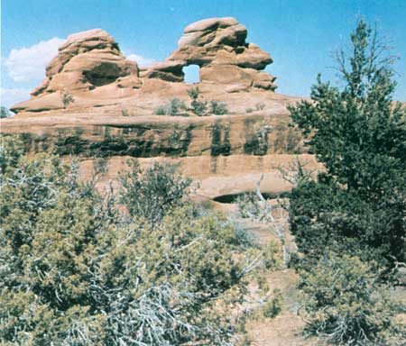
Professor Stevens found 14 arches in what he called upper Devils Garden, northwest of Double O Arch, and two arches in the northwesternmost extension of the park known as Eagle Park (fig. 1). One of the unnamed arches in upper Devils Garden is shown in figure 58. I am tentatively calling it "Indian-Head Arch," because of the rather obvious resemblance.
|
| "INDIAN-HEAD ARCH," in upper Devils Garden. Arch and most of head are in Slick Rock Member, top of head is basal part of Moab Member. Opening is 4 feet wide and 4-1/2 feet high. Photograph by Professor Dale J. Stevens, Brigham Young University. (Fig. 58) |
This ends our journey through Arches National Park, but there remains for consideration a summary of the principal geologic events leading to the formation of this beautiful part of the Colorado Plateau and a brief comparison with the geology of other national parks and monuments on the Plateau.
| <<< Previous | <<< Contents >>> | Next >>> |
bul/1393/sec10g.htm
Last Updated: 8-Jan-2007