
|
Geological Survey Bulletin 1444
Geology and Thermal History of Mammoth Hot Springs |
INTRODUCTION
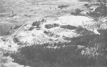
Mammoth Hot Springs, located about 8 km inside the north entrance of Yellowstone National Park, consists of nearly 100 hot springs scattered over a score of steplike travertine1 terraces (fig. 1), which descend almost continuously from the top of Terrace Mountain to the banks of the Gardner River (fig. 2). Several of the terraces contain unusual ridge- and cone-shaped hot-spring deposits, and other terraces are characterized by a myriad of colors owing to algae and bacteria that live in the hot springs and runoff areas. The natural beauty of these imposing travertine deposits, combined with the variegated hot springs, makes Mammoth Hot Springs one of the foremost attractions in Yellowstone Park.
1See "Glossary" at end of report for definitions of italicized geologic terms.
|
| Steplike travertine terraces at Mammoth Hot Springs (fig. 1). Several large Hat travertine deposits lie between Prospect Terrace (pt) on the right and Opal (ot) and Hymen Terraces (ht) on the left (see pl. 1). Photograph courtesy of D. E. White, U.S. Geological Survey. |
|
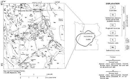
| Geologic map of Mammoth Hot Springs and surrounding area (fig. 2). Small index map shows location of Norris Geyser Basin (N), Norris-Mammoth fault zone (dashed line), and approximate outline of the rim of the Yellowstone caldera (YC). Geology generalized from Ruppel (1972), U.S. Geological Survey (1972), Pierce (1973), Bargar and Muffler (1975), and unpublished geologic mapping of R. L. Christiansen, H. J. Prostka, E. T. Ruppel, and H. W. Smedes, all of the U.S. Geological Survey. (click on image for a PDF version) |
The Hayden Survey (one of the four precursors of the U.S. Geological Survey), charged by Congress with investigating the geology and natural history of the Yellowstone region, included in their reports (Hayden, 1872, 1873, 1883) the first published descriptions of the thermal feature they named "White Mountain Hot Springs."2 During later years, numerous workers, notably Allen and Day (1935), contributed much information on the geology and thermal history of Mammoth Hot Springs; however, no attempt was made to correlate all of the available material. Accordingly, the purpose of this report is to summarize the relevant data concerning the geology of the travertine deposits and the history of hot-spring activity at Mammoth Hot Springs.
2A. C. Peale, one of the members of the Hayden Survey, credits the name "Mammoth Hot Springs" to the residents and transient hot-spring bathers met by the first Hayden expedition (Peale, 1883). Earlier names for Mammoth Hot springs were "White Sulphur Banks" on the 1839 map of Captain Washington Hood and "Sulphur Mountain" on the 1851 maps of the famous mountain man Jim Bridger and the Jesuit priest Father Pierre-Jean de Smet (Haines, 1974, p. 187-189).
Acknowledgment.—The author gratefully acknowledges the help of R. Alan Mebane, the Chief Park Naturalist of Yellowstone National Park, for providing access to the naturalists' files, which proved to be of great value in compiling the history of hot-spring activity at Mammoth.
| <<< Previous | <<< Contents >>> | Next >>> |
bul/1444/intro.htm
Last Updated: 20-Nov-2007