|
Geological Survey Bulletin 1493
The Geologic Story of the Great Plains |
WHAT IS THE GREAT PLAINS?
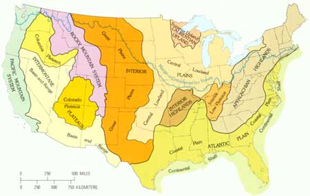
The United States has been subdivided into physiographic regions that, although they have great diversity within themselves, are distinctly different from each other (fig. 2). From the Rocky Mountains on the west to the Appalachians on the east, the interior of our country is a vast lowland known as the Interior Plains. These plains are bounded on the south by a region of Interior Highlands, consisting of the Ozark Plateaus and the Ouachita province, and by the Coastal Plain. In the Great Lakes region, the Interior Plains laps onto the most ancient part of the continent, the Superior Upland. West of the Great Lakes it extends far to the north into Canada. Certainly the Rocky Mountains are distinctly different from the region to the east, which is the Great Plains. The Great Plains, then, is the western part of the great Interior Plains. The Rocky Mountains form its western margin. But what determines its eastern margin?

|
| Figure 2.—Physical divisions of the United States and maximum extent of the continental ice sheets during the Great Ice Age. (click on image for an enlargement in a new window) |
During the Pleistocene Epoch or Great Ice Age, huge glaciers formed in Canada and advanced southward into the great, central, low-lying Interior Plains of the United States. (See figure 2.) These glaciers and their deposits modified the surface of the land they covered, mostly between the Missouri and the Ohio Rivers; they smoothed the contours and gave the land a more subdued aspect that it had before they came. This glacially smoothed and modified land is called the Central Lowland. Although the ice sheets lapped onto the northern part, the Great Plains is the largely unglaciated region that extends from the Gulf Coastal Plain in Texas northward into Canada between the Central Lowland and the foot of the Rocky Mountains. Its eastern margin in Texas and Oklahoma is marked by a prominent escarpment, the Caprock escarpment. Its southern margin, where it abuts the Coastal Plain in Texas, is at another abrupt rise or scarp along the Balcones fault zone.
| <<< Previous | <<< Contents >>> | Next >>> |
bul/1493/sec1.htm
Last Updated: 28-Dec-2006