
|
Geological Survey Bulletin 1673
Selected Caves and Lava Tube Systems in and near Lava Beds National Monument, California |
OTHER CAVES IN OR NEAR THE MONUMENT
(continued)
Merrill Ice Cave, Bearpaw Cave, and Nearby Collapse Trenches
A line of large collapse trenches begins along the east base of the large cinder and agglutinate cone named Bearpaw Butte, 2 mi north of Mammoth Crater. From there, this line of collapse trenches can be traced east and north around the Schonchin Butte flow for about 10 mi. The collapse trenches were formed by the collapse of roofs in a system of two to three or more lava tubes stacked above one another. These tubes served as feeder conduits through which molten lava escaped from a former lava lake fed by Mammoth Crater (map 19, pl. 6). This lava built a plain downstream covering approximately 50 square miles to the north and northeast of Bearpaw Butte. The lava dispersed through the Bearpaw tubes, surrounded Schonchin Butte, and spread northward to the shores of Tule Lake. The lava lake that spawned the Bearpaw tubes eventually drained to a lower level through a lava tube that burrowed through loose cinders around the base of Red Butte and then contributed to the lava-tube system of the Cave Loop Road area.
Most of the surface collapse trenches that currently mark the position of feeder tubes in the Bearpaw-Skull system range from 50 to 1,500 ft long. Partly destroyed relics of lava tubes survive between the collapse trenches as caves, natural bridges, and tubes blocked with congealed lava. Two of these caves, a natural bridge, and three large collapse trenches are shown on map 10, plate 4.
Merrill Ice Cave is accessible by a paved road leading to a parking lot, and then by trails and stairs to the cave's two levels. Bearpaw Cave is also easily accessible, although not by developed trails. Its entrance is the mouth of a huge domed cavern at the upstream (south) end of the large collapse trench over which the paved road crosses via a natural bridge.
According to National Park Service records, the names "Bearpaw Cave" and "Bearpaw Butte" are derived from the activities of pioneer trapper Tom Durham, who killed a bear and nailed its severed paws to a juniper tree above the entrance of the cave. Merrill Ice Cave whose deeper, ice-bearing level was discovered later was named "Bearpaw Cave" at first, but in 1938 the Park Service changed the name to "Merrill Ice Cave" in honor of Charles Henry Merrill whose land was donated to the monument (National Park Service, unpub. data, 1965).
Merrill Ice Cave consists of two superposed lava tubes. The entrance level is accessible for a distance of 290 ft. The lower ice level is 360 ft long; about one-third of its floor area is occupied by pools of ice or by collapse rubble cemented with ice. The only entrance to the ice level is by a steel ladder placed through a hole a few feet in diameter in the floor of the entrance level. On the map the ice level is offset from its true position to avoid confusion with the lines and lettering of the entrance level.
Bearpaw Cave is accessible for 300 ft upstream from its high-domed entrance. The cavern at its mouth is 60 ft high and 35-50 ft wide. The upper section of the cave is much smaller and is nearly closed at its south end by large blocks of collapse rubble.
Merrill Ice Cave, Entrance Level
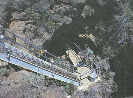
From the north side of the parking lot a trail leads northeast 250 ft to a stairway (fig. 45) placed against the west wall of a 20-ft-diameter hole in the roof of a lava tube, which constitutes the entrance level of Merrill Ice Cave. From the foot of the stair the tube extends upstream 85 ft to where it opens into the north end of the collapse trench that lies just northeast of the parking lot. At the opposite upstream (southwest) end of the collapse trench is the natural bridge that supports the road to Merrill Ice Cave.
|
| Figure 45. Stairway leading down to entrance of Merrill Ice Cave (see fig. 4 and map 10, pl. 4). |
Downstream from the base of the stairway, a trail and in some places a boardwalk provide easy access over the hummocky piles of collapse rubble littering the cave floor. A narrow bench on the southwest wall of the tube records shallow ponding of lava during a late episode of withdrawal. Some collapse blocks appear to have been derived from tube-in-tubes, which may have only partly filled the main tube before their drainage and eventual collapse.
At a point 160 ft downstream from the stairway, a 16-ft ladder extends down through a small hole in the floor of the entrance level to the edge of an ice pond on the lower level. The entrance level extends downstream only another 40 ft beyond the top of the ladder, and it is this short section that reveals much information about the origin of the entrance level. In this downstream section, the level is blocked by successive shells of lava accreted to the walls. Each shell is a record of one episode of filling and partial draining. Each molten flood deposited a layer of lava plaster upon the tube's walls, roof, and floor as its edges chilled against the colder rock encasing it; then, the still-molten lava beneath the thin coating drained away before completely solidifying.
At this downstream end the tube plunges and is constricted to a fraction of its upstream size. A smaller opening once drained lava from the entrance level to an underlying tube. Nevertheless, during each episode of maximum volcanic activity the tube would fill completely with lava, and as the eruption waned, the molten interior drained slowly through the opening and left a layer of lava plaster behind. Successive layers thus accreted until, as seen today, the opening is too small to crawl into. Since cessation of volcanism many of the accreted layers have loosened and partially peeled away from the roof and walls. Peeling layers are also well exposed at the upstream end of this level where the wall of the collapse trench slices across the lava tube to reveal telescoped shells of dripstone and lavacicles.
Merrill Ice Cave, Ice Level
The ice level of Merrill Ice Cave is a 360-ft-long remnant of a medium-sized lava tube that is 15-20 ft wide and originally was 12 ft high. It is closed by roof collapse at both ends and its floor is completely obscured by collapse rubble and ice ponds. The roof and walls have been so greatly enlarged by slow unraveling of collapse blocks that few original features remain. Low benches are partially visible from beneath the collapse debris in the downstream part.
The most striking geologic feature in this level is a steep-walled depression in the floor 40 ft upstream from the foot of the ladder. An ice pond 25 ft in diameter occupies the central part of this depression. Steep slopes of ice-encased collapse rubble rise on both ends of the ice pond, and the upstream slope actually forms a frozen cascade. It seems that the pond marks the site where the floor of the ice level collapsed into a third, and probably larger, lava tube below. Moreover, it seems probable that this lower tube is currently filled with ice.
An account of how ice develops within caves and descriptions of more impressive ice deposits are given in the "Crystal Cave" and "Ice Deposits" sections. Merrill Ice Cave, however, is a much safer cave than either Crystal Cave or Skull Cave's ice level. Moreover, the well-planned trail makes the extensive ice accumulations in Merrill Ice Cave easy to visit.
Three ice pools (map 10, pl. 4) occupy one-fourth of the floor space. One at the foot of the ladder and another near the upstream end of the ice level tube that extends 70 ft and includes many "islands" are situated in low spots on the floor of the lava tube. The third pool is at a lower elevation and, as mentioned, fills a round hole that apparently connects the ice level with a lower ice-filled tube.
Most ice in the shallow upstream pool is fairly transparent, and shadowy outlines of the blocks that project above the pool's surface can be traced to depths of a few feet below the surface. Much of the cave's ice, however, is murky with dust, small bubbles, cracks, and organic growth.
The beautiful draperies of transparent icicles and expanses of permanent hoarfrost in Crystal Cave are totally absent in Merrill Ice Cave. Thin rimes of hoarfrost form in parts of Merrill Ice Cave during the winter months, and short, thin icicles develop for a brief period during the spring thaw; but these features come and go with the changing seasons. The formation of a water puddle in the late summer and autumn over the top of all three ice ponds is evidence of a greater seasonal exchange of warm air for cold air in the two levels of the cave. Why the difference between the two caves? Two explanations seem probable. (1) Crystal Cave is much larger and deeper than the ice level in Merrill Ice Cave. A far greater volume of air must be exchanged before there is a marked temperature change in Crystal Cave. (2) Although both caves have only one obvious entrance, one must consider air flow from a second area into Merrill Ice Cave through the ice level. Note on the map that the south end of the ice level is closed by the steep slope of collapse rubble from the northernmost collapse trench. Openings between these large blocks are surely big enough to allow considerable interchange of the cave air with the outside air. The sun shines strongly upon this part of the collapse trench at midday, affording an ideal case where cold air of the cave flows out into the collapse depression, is warmed, and rises—a continual mechanism pumping cold air from the cave between day and night during the summer months.
Web Edition Note: Merrill Ice Cave, one of the larger ice resources in the monument, began to erode with the formation of a hole in the center of the ice floor. By 2001, the entire ice resource had practically disappeared.from Appendix F of Vital Signs Monitoring Plan for the Klamath Network: Phase I Report
Bearpaw Cave
Bearpaw Cave is a large lava tube that has lost nearly all of its primary features by slow unraveling of its roof and walls (map 10, pl. 4). The entire cave floor is mantled with collapse rubble. A long-abandoned well, dug into this rubble at a point 55 ft upstream from the entrance contains water; thus the pahoehoe floor of the cave was probably reached by the well. In the same area, remnants of a lava bench, almost obliterated by the cover of rubble, are present in places along each wall. On the west wall, above the bench, is a large curving alcove on which dripstone still remains. The alcove slopes out at its base and merges with the bench below.
Upstream beyond the large cavern that contains the alcove, bench, and water well, the cave changes markedly. The ceiling height drops as the amount of rubble on the cave floor increases. The walls narrow until the passage is only 18-20 ft wide, but the west wall swings out another 10 ft into a rounded alcove near the top of the incline. This upward-funneling tube extends upstream for 170 ft almost to the end of the accessible part of the cave. Nowhere on this moderately steep slope is there an exposure of the original floor of the cave; it appears to be everywhere buried under collapse rubble. The length and uniform gradient of the slope, however, are a strong indication that this part of the tube was a lava cascade.
The southernmost end of the accessible part of Bearpaw Cave is a small passageway that opens amid the collapse blocks beneath the northwest corner of a big collapse trench to the south. This passageway is only a random hole in the collapse rubble; it does not indicate the course of the former upstream continuation of the original lava tube.
Collapse Trenches
To many monument visitors the deep collapse trenches, the varied topography to the south and west of the Merrill Ice Cave parking lot, and the sharp changes in biologic life zones may be more interesting than the caves. This parking lot is a junction between three zones of vegetation. To the south the deep collapse trenches are obscured upstream beneath dense thickets of mountain mahogany, which occupy the rough schollendomed surface between Bearpaw Butte and Hippo Butte (fig. 4). Immediately to the west Bearpaw Butte rises high enough to support an evergreen forest. North and east of the parking lot are rough plains cloaked with bitter cherry, rabbit brush, sagebrush, and small annuals. Additionally, various plant communities thrive in the microclimates of the caves and collapse trenches, including lichens and mosses that grow on the shady side of the vertical-walled collapse trenches and in the moist, cool air of the cave entrances.
A limited supply of water remains throughout part of the summer in small shaded rock niches—similar to the "tanks" in the Southwest, as they are called by naturalists. A poorly accessible but permanent supply of water is found in the abandoned well of Bearpaw Cave, and water also comes from partial melting of ice pools in Merrill Ice Cave. Availability of water is a critical factor in supporting a larger than average population of animals, especially rodents. Birds are more abundant here than in most parts of the monument.
The two northern collapse trenches (map 10, pl. 4) are geologically quite ordinary. Note their vertical scarps, which expose flow units of lava (for a description of flow units and their relation to lava tubes, see the "Post Office Cave" section). Below these scarps the floors are elongate saucers of collapse rubble. A simple calculation of the volume of the trenches below ground level shows that roof collapse of both levels of Merrill Ice Cave is inadequate to provide the space occupied by the trenches. Either or both of two explanations could account for this discrepancy. (1) Beneath the ice level of Merrill Ice Cave there is one or more lava tubes whose collapse provided the extra space to hold the rubble. (2) Molten lava flowing through the collapsing tube or tubes was of sufficient volume to remove most of the blocks that fell into it. Very likely, both processes contributed. Good examples of collapse blocks smoothed over or rafted away by lava are present in Valentine (map 8, pl. 3), Catacombs (map 3, pl. 1), and Tickner and Berthas Cupboard Caves (both on map 9, pl. 3). Examples of collapse trenches whose volume conforms with the size of the tube, and some that do not, are found along the course of the same lava-tube system downstream from Merrill Ice Cave—especially in the 5-mi stretch downstream from Skull Cave (see map 20, pl. 6, and the "Skull Cave" section).
Hydraulic Rampart
At the northeast end of the collapse trench at the head of Bearpaw Cave is evidence of uplift and subsidence of the roof of Bearpaw Cave at a time when it was filled with molten lava. The evidence here also sheds some light on the probable origin of the inferred lava cascade in the upper part of Bearpaw Cave.
The downstream end of this southern collapse trench is bordered by two unusual deposits not found around the edges of the other two downstream collapses. One is a partial girdle of loose lava blocks derived from the flow that formed the vertical cliffs along the edge of the collapse. These blocks, however, are piled up in a ridge on the top of the flow, like a ring of dirt thrown out from an excavation. The other feature, at the northwest corner of the trench, is a short lobe of pahoehoe lava that spilled over the wall of the trench and extended 50 ft on the surface before its source of lava subsided into the trench (see map 10, pl. 4).
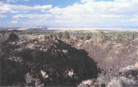
Ridges of loose blocks that rise above the rim of certain breakdowns are interesting structures, which we have named "hydraulic ramparts" (fig. 46). Hydraulic ramparts may form when an obstruction backs up lava within a tube. The ponded lava rises upstream inside the tube until its hydraulic pressure becomes great enough to either break through the obstruction or else force a hole through a weak spot in the roof of the tube, allowing the lava to spill out onto the surface as a lava flow.
|
| Figure 46. Collapse trench near Merrill Ice Cave (see fig. 4 and map 10, pl. 4). Collapse of tube roof occurred before final flow of lava through tube. Lava backed up in tube and pushed blocks out, forming an encircling rim of loose blocks, called a "hydraulic rampart," best seen in left foreground. In distance to north is Tule Lake, bounded on west by fault scarp known as Gillem Bluff. |
We infer that hydraulic pressure above a blockage in Bearpaw tube lifted the roof of the tube over the downstream part of the present collapse trench by breaking the roof along two lines, one across the course of the tube and the other parallel to its west wall. This pie-shaped slab was tilted up, similar to lifting a trap door, as molten lava rose beneath it. As this occurred, its north edge collapsed and formed the hydraulic rampart shown on the map. Simultaneously, molten lava squeezed up the break along the west side and spilled onto the surface as a pahoehoe lobe (see map 10, pl. 4). Prior to this, however, the impeded lava enlarged the outlet underground by prying up the roof north of the intersection of the two breakage lines and created a new passage along the route of the inferred lava cascade in the upper part of Bearpaw Cave; this process caused the lava level to fall in the upstream part of the tube. The trap door began to close, and the lava feeding the pahoehoe surface lobe was diverted back down to the underground lava cascade. With cessation of volcanic activity the tube drained, and this draining allowed the trap door to tumble into the collapse trench as a pile of loose blocks.
This scenario is somewhat hypothetical because the only evidence is part of a hydraulic rampart, a small overspill of pahoehoe on the surface, and an inferred lava cascade obscured by collapse debris. If the scenario is correct, the obstruction probably occurred in a former extension of Bearpaw tube just northeast of the hydraulic rampart. This part of the inferred tube may have extended much farther northeast and followed the projected course of the collapse trench in the area upstream from the hydraulic rampart. After taking this inferred course for at least 100 ft, the tube turned abruptly west and joined the Bearpaw tube at the curving alcove in the large entrance cavern. Obstructions in lava tubes are frequently caused by roof collapse at sharp bends and are augmented by lava jams behind the collapsed blocks. The obstruction backed up the lava sufficiently to raise the trap door, and so a little lava spilled onto the surface. Then, a ridge of talus (hydraulic rampart) collapsed across the downstream break before the lava took an underground shortcut across the former bend by means of a lava cascade around the west side of the blocked area.
| <<< Previous | <<< Contents >>> | Next >>> |
bul/1673/sec3b.htm
Last Updated: 28-Mar-2006