
|
Geological Survey Bulletin 1673
Selected Caves and Lava Tube Systems in and near Lava Beds National Monument, California |
OTHER CAVES IN OR NEAR THE MONUMENT
(continued)
Post Office Cave
Post Office Cave (map 15, pl. 5) is geologically the most complex lava-cave system in Lava Beds National Monument and is one of the most difficult to explore. The entrance and exit to Post Office Cave used when the cave was mapped in 1975 were closed by a slide and a rockfall in 1977-78, but by 1988 they had been reopened. The cave is entered at the downstream end. The cave system extends upstream for a linear distance of 2,080 ft. but many different levels of the cave system are superimposed one above another. Counting the footage of each accessible level, the Post Office Cave has more than 5,170 ft of passageway (see longitudinal section the map). It is much easier to find one's way from the upstream end of the Cocoa Pipeline (the deepest lava tube of Post Office Cave) to the surface via the exit than it is to climb down into the deep parts of the cave using the upstream opening as an entrance.
General Pattern of Post Office Cave
The Post Office Cave system consists of the collapse remnants of from four to seven lava tubes superposed almost directly above one another (fig. 51). Collapse through their floors and ceilings now connect and provide access to these vertically stacked tubes. Most breakdowns between levels occurred after volcanism ceased, but fine examples of collapses that occurred while molten lava still occupied one or more of the tubes are also present. In places spectacular lava falls and lava cascades, frozen upon the edges of the breakdowns, are preserved undamaged. Post-lava collapses, however, allow examination of the rocks that enclose a lava tube. The last lava to fill a tube seals its walls and ceiling with dripstone and lavacicles and its floor with pahoehoe; thus, the record of earlier events is hidden beneath a coating of lava plaster. The broken walls, floors, and ceilings of the Post Office Cave conduits reveal extremely complex stages of recurrent filling, collapse, and draining of lava tubes.
|
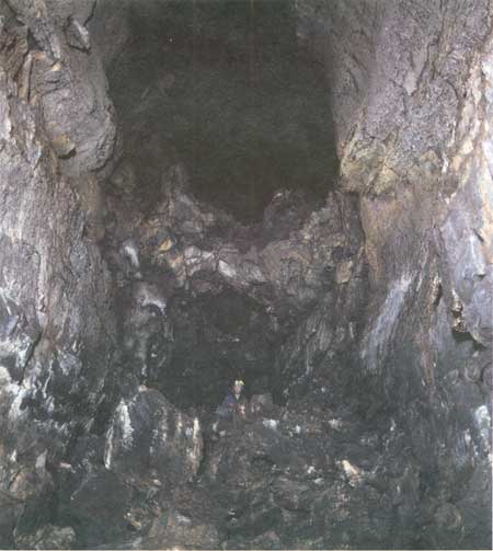
| Figure 51. Multiple stacked tubes characterize Post Office Cave (see fig. 4). The Silver Connector (see map 15, pl. 5) internal breakdown exposes at least seven superposed levels. The deepest known point in Post Office Cave is 136 ft below surface. Person in lower tube for scale. |
The superposition of the Post Office lava tubes in a nearly vertical stack appears to have been controlled by preexisting topography. The flow that contains the deepest tube evidently followed a valley or canyon. Flow-unit contacts and platy jointing in these lower lavas dip toward the axis of the system. As later flows were added to the pile, the lava tubes—which formed in the thickest and most rapidly flowing part of a lava flow—were superposed by confinement of the flows between the valley walls. Eventually, however, some new surface flows spilled over the valley walls and sent distributary lobes away from the axis of the former valley. One of the more complex examples is Silver Cave (map 14, pl. 5), which splits off as a distributary from one of the highest lava tubes of the Post Office axis. The Silver Cave lava tube, however, diverged from the Post Office axis for only a short distance before flowing roughly parallel with the axis again.
Before entering Post Office Cave it is worthwhile to make a brief study of the profile and map to acquire a general impression of the cave's complicated overlapping passageways. A glance at the profile shows that the central part of the cave consists of two lava tubes. An upper larger one called the Silver Connector level is superposed above a smaller tube called the Cocoa Pipeline. Closer examination of the map and the cross section (map 15, pl. 5), and especially a visit to the two cave levels, shows at once that the Cocoa Pipeline is no smaller in width than the upper level, however, its ceiling is lower. The Cocoa Pipeline is a large, fairly intact lava tube—15-30 ft wide and 8-12 ft high—with a uniform oval cross section like that of a subway tunnel. It displays the typical features that characterize intact lava tubes. On the other hand, the Silver Connector level is more varied in width, although on average it is no wider than the Cocoa Pipeline. In striking contrast to the Cocoa Pipeline its cross section is vertically elongated instead of horizontally oval. Its ceiling height varies between 30 and 45 ft, and in parts of its course that height would be doubled if we could remove the piles of collapse debris which litter its floor. The Silver Connector level is the hole left after piecemeal collapse of at least five lava tubes originally stacked one above another. This wholesale collapse of the separations between the tubes created a cave floor that is hummocky and difficult to traverse. Many blocks are exceptionally large—a few are as long as 40 ft. Very few "in-place" remnants of the walls of the original lava tubes have survived. The remarkable feature about this level is that it did not completely collapse to the surface and form an open collapse trench like the one at the downstream entrance. One possible explanation of the strength of this part of the roof is that the highest accessible lava tube at both the upstream and downstream ends of the Post Office Cave is filled with congealed lava. This filling may have formed a strong massive strut that has prevented interior collapse from working upward to the surface.
Remnants of certain passageways that collapsed together to form the high central part of the Silver Connector level have been given names to facilitate description (see map 15, pl. 5). Where a passageway consists of an opening formed by the integration of two or more tubes by collapse, we call it a "level." If only one main lava tube is dominant, we call that one a "tube." Only the larger tubes and levels have been named. Small vertical breakdowns between tubes or levels are unnamed, but we use "connector" for the larger semicylindrical breakdowns that cross vertically through the position of two or more tubes and yet do not reach the surface.
Two connectors described herein at some length are the Silver Connector (fig. 51 and map 15, pl. 5) and the Cataract Connector. The Cataract connector, near the east end of Post Office Cave, is an excellent example of a connector that formed by collapse between the lava tubes while one or more were occupied by molten lava. One of its walls has an 18-ft-high lava cataract that was frozen in place while molten lava was cascading into the hole. Other parts of this connector's walls are plastered with lava dripstone that leaked through holes in the fragile floor of a level above them.
The Silver Connector gives its name to the Silver Connector level. The Cataract Connector gives its name to two lava tubes, the Upper Cataract Tube and the Lower Cataract Tube. Each tube is compound and in places splits into two or more parts, but this splitting is due to the building of internal balconies and not to breakdown between separate tubes.
The Upper Cataract Tube lies just beneath the eastern part of the Silver Connector level and at its west end merges with that level through a roof collapse. In the much deeper parts of the Silver Connector level farther west, the Upper Cataract Tube is undoubtedly one of the components of the enlarged Silver Connector level (see longitudinal section on map 15, pl. 5).
At the upstream end of the Post Office Cave the relations of passageways are similar. Above the Cocoa Pipeline the four largest tubes or levels have been given names. Above the Cocoa Pipeline tube is the Cocoa entrance level, which involved two tubes, one above the other. Still higher is the upper entrance level; it subdivides eastward into upper and lower tubes. And still higher are the Silver Cave levels (maps 14 and 15, pl. 5).
The Silver Connector extends vertically through at least four and perhaps seven of these levels; it stops below them but above the Cocoa Pipeline. Within 200 ft downstream from the Silver Connector, most of these levels have merged through collapse to form the high-ceilinged part of the Silver Connector level. The Cocoa Connector, and the Central Connector downstream, are breakdown holes that reach the Cocoa Pipeline.
Because of the difficulty of showing superposed levels on a map, some levels are offset for the sake of clarity and line variations are used to help distinguish certain levels. Collapse rubble completely covers the floors of the Silver connector level and Cocoa entrance levels but is almost absent in the roofed-over parts of the Cocoa Pipeline and a few of the other tubes.
With this preliminary explanation of the features, an upstream traverse through Post Office Cave is described. It starts at the collapse trench that gives access to the main entrance and ends at the upstream end of the Cocoa Pipeline with a climb through overlying tubes and levels to the upstream exit.
Collapse Trench at Downstream Entrance
The collapse trench that leads to the downstream entrance of Post Office Cave (map 15, pl. 5) is 220 ft long, 80 ft across at its widest point, and 50 ft deep. Its walls in most places are nearly vertical, and large underground caverns open at either end of the trench. The downstream cavern leads beneath Post Office Natural Bridge to a downstream breakdown trench; the upstream cavern contains the entrance to Post Office Cave.
In January of 1918, J.D. Howard clambered down the upstream wall of the trench, explored the cavern at its head, and from the side of this cavern crawled upstream along the downstream entrance tube (see map 15, pl. 5) to the point where his way was blocked by lava that filled the tube to its roof. Evidently he did not find the small and inconspicuous crawlway through collapse debris in the middle of the entrance cavern floor that gives access to the main parts of Post Office Cave, for he disappointedly wrote, "it isn't much of a cave, as it is only an opening with a crawler at the back end." Howard called the cave Post Office because of the many "pigeon holes" in the cliff above the entrance cavern. These reminded him of post office boxes. This clutter of small openings is one of the particularly interesting features of the collapse trench. They apparently formed in either a skylight on the top of a large tube or in a surface channel through which molten lava was actively moving downstream. In either case the surface of the molten flood (as observed in Hawaii and at other active volcanoes by Peterson and Swanson, 1974) congeals from the walls of the opening, but before it can crust over completely, minor fluctuations in the height of the lava river cause recurrent partial crusts to form and attach to the walls of the opening at slightly different heights. Withdrawal may occur when a crust is so thin, hot, and pliable that it cannot support itself; it breaks and may curve downward into a roll. A rise in lava level may break it and curl it upward. In other places the broken-off edges of such crusts are plastered over by lava splashing upon them, or by rise of the lava surface. The holes are by no means as geometric and regular as post office boxes. Some are rectangular, most are irregular, and a few are almost cylindrical. Some also contain curls of lava crust, like rolled magazines thrust into a small post office box. The wall above the Post Office entrance cavern is an excellent example of the filling to be expected on the edges of a crusted-over skylight.
The collapse trench continues downstream after interruption by the Post Office Natural Bridge and another natural bridge. Similar skylight-type features show in places on the roof and in parts of the ends of these natural bridges as well, but these features do not extend through the entire length of the bridges.
Flow Units
Another feature of interest in the collapse trench is the division of the lava in the sides of this trench into many flow units (Nichols, 1936). Flow units are created when a surface lobe of erupting lava advances fast enough to continuously override the lava surges that recurrently burst out from its front and sides as the lava advances. Flow units are easy to recognize when pahoehoe rubble has been formed and welded together at the top and bottom of each successive surge. Often, however, the contact between many flow units consists only of lava froth with bubbles of steam and air that was smeared into patches and partings by either an overriding or underriding flow unit (Waters, 1960). The order in which flow units congeal is not necessarily from the bottom of the flow upward. Basalt flows may produce a thick crust on their top while the interior of the flow is still molten and moving forward. It is in this kind of layered lava that many large lava tubes develop (Ollier and Brown, 1965; Hatheway and Herring, 1970; Greeley and Hyde, 1972; Wood, 1976). Most flow units in the walls of the Post Office collapse trench are 2-12 ft thick, but some appear to be thicker. On closer inspection one finds that most thicker units are compound and subdivided by platy partings that show evidence of shearing and recongealing along surfaces of flow. The north wall of the collapse trench shows a continuous 75-ft-thick section of flow units; the thickest unit is as much as 20 ft thick, but it is a compound unit divided into several subunits along discontinuous zones of flattened vesicles or along platy joints that were formed by the collapsing and shearing of vesicles.
Lava tubes, according to one prevailing theory, are supposed to form within the thickest and most rapidly moving parts of lava flows. Such flows generally subdivide into flow units of the various kinds well displayed on the walls of this trench. Halfway up the south wall, the flow units dip gently inward as they approach the axis of the Post Office tube system—a relation commonly seen adjacent to the walls of most large lava tubes. By contrast, high on the north wall of this trench the flow units dip outward, roughly parallel to the ground surface. These upper flow units may indicate that the valley which contained the vertical stack of Post Office tubes had filled and that younger flows subsequently overtopped the valley walls to the north; then levees of flow units and thin flows spread outward from the channel. When this levee-building situation is reached, the topmost feeder tube within a pile generally begins to subdivide into numerous small distributaries. A characteristic example, previously described, is the complicated distributary pattern of Catacombs Cave.
Entrance Cavern and Downstream Entrance Level
Howard's statement, "an opening with a crawler at the back end" is an appropriate summary. The big cavern at the entrance has ceiling heights of as much as 40 ft. Its southeast wall has collapsed extensively and forms a slope of loose blocks that extends to the middle of the cavern floor. The northwest wall is more intact with patches of dripstone and small rubble piles. Upstream the cavern walls narrow markedly, and at a point 160 ft upstream the ceiling lowers to 10-12 ft. Still farther upstream the downstream entrance level is free from collapse but is filled nearly to its roof with lava. Continuous lavacicles and dripstone cover its walls and ceiling. The last 30 ft is a "crawler" only 1-2 ft high, which is impassable farther upstream. Mapping of the remainder of Post Office Cave showed, however, that this tube is a continuation of the final tapering downstream end of the upper part of the Silver Connector level. The inaccessible part between them is only 10 ft long, but it prevented Howard from discovering the main parts of Post Office Cave.
A breakdown in the ceiling of the cavern 200 ft from the cavern entrance opens a hole that leads to a small upper tube. A ladder 20 ft or longer is needed to reach the hole. Complete collapse of its floor contributed to the 40-ft ceiling height of the entrance cavern.
Upper Cataract Tube
At a point 180 ft upstream from the mouth of the entrance cavern, a crooked 2- to 3-ft crawlway leads 20 ft downward through collapse blocks. The passageway drops through the ceiling into a 7-ft-high lava tube called the Upper Cataract Tube (see longitudinal section on map 15, pl. 5). This tube continues upstream 375 ft to a point where its roof opens into the overlying, extensive Silver Connector level.
The walls of the downstream part of the Upper Cataract Tube arch upward steeply for 50 ft and meet overhead at an acute angle. The remainder of the tube upstream has a normal, smoothly rounded ceiling. Many features indicate that the Upper Cataract Tube has had a long, complex history of repeated draining of and refilling by molten lava. Both angled and rounded ceilings show several successive accretionary linings of lava plaster. In places these have peeled from the roof and walls in such quantity that the floor is covered with rubble.
Much additional evidence of repeated draining and refilling of this compound tube can be gained from the study of four breakdowns in the floor of the tube and from investigation of the interesting passages, rooms, and subbalcony passages into which these breakdowns lead. These breakdowns are described in order as one proceeds upstream through the Upper Cataract Tube.
Red Plaster Room
Upstream 45 ft from the crawlway entrance, the floor of the Upper Cataract Tube drops away in a semicircular hole onto a rubble-covered slope 8 ft below. This slope tilts downstream (northeast), and one can follow it by squeezing under a low-ceilinged arch beneath the lip of the breakdown scarp. Beyond the arch is an irregularly shaped room 40 ft long, as much as 18 ft wide, and 6-10 ft high. We named it the Red Plaster Room for a thin coating of reddish lava plaster—one of many lava coatings—that was deposited upon the walls and roof of this room.
This extremely complicated room is evidently a short remnant of a lava tube that once extended much farther downstream. Direct evidence of its former extension as a tube is present in the high shelf just under the roof at the downstream end of the room. One can extend a stadia rod more than 20 ft beyond the thin crawlspace on the top of this shelf.
On the east wall of the Red Plaster Room, 4 ft above the floor, are the remains of a lava bench marking the highstand of a pool of lava that occupied this room long enough for a thick lava crust to form inward from the wall. This bench juts out from the wall as a shelf 2-4 ft wide. Several blocks as much as 2 ft long have tumbled from the roof and walls and landed on this shelf. Some of these blocks evidently dropped while the crust of the pool was hot and plastic, for parts of the bench sag beneath them. The continuation of the congealing crust toward the center of the room was broken off and carried downstream by a resurgence of new lava in addition to lava still draining beneath the crust. Soon after this episode, molten lava again filled the Red Plaster Room to well above the level of the bench. This lava completely plastered over and welded together the remains of the bench and the fallen blocks resting upon it (fig. 52). The molten lava again withdrew and left a 2- to 6-in-thick coating of lava plaster. The outline of the fallen blocks, the broken-off bench, and many other features on the walls of the room can be identified despite this coating.
|
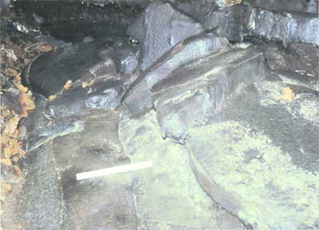
| Figure 52. Lava entirely filled this part (Red Plaster Room) of Post Office Cave (see fig. 4 and map 15, pl. 5) and then drained away leaving a thin coating of lava. Lumpy shapes in lower right are fallen blocks coated with a late plaster of lava. Scale bar is 1 ft long. |
On the west wall in irregular alcoves, projections, and reentrants (made where fallen blocks were carried away by the flowing lava), layer upon layer of lava plaster was accreted at irregular openings in the walls and roof. Evidently the Red Plaster Room was repeatedly filled by surges of lava that drained out of the chamber almost as soon as it was filled.
Some clues to the possible cause of these repeated fillings and drainings can be gained from the geometry of the Red Plaster Room in relation to the nearby passages and openings. As noted, a uniform slope connects the upstream floor of the Red Plaster Room with the floor of the Upper Cataract Tube above. The incline drops 20 ft over a horizontal distance of 30-35 ft. The slope is so thoroughly masked under collapse rubble that the exact nature of its surface cannot be determined definitely, but it seems reasonable to assume that this slope marks a lava cascade, which dropped molten lava 20 ft into an underlying tube. The Red Plaster Room, at the base of this cascade, is a remnant of this tube. Irregular surges and changes in level would be expected at the base of a cascade as lava forced its way downstream through a tube cluttered and constricted with roof collapses.
Second Breakdown
Leave the Red Plaster Room, proceed 90 ft up the Upper Cataract Tube, and note a small oval hole in the floor of the tube. One can squeeze through this hole and into a well-preserved broad (8 ft) but flat-topped and 3-ft-high tube that extends back downstream for 95 ft to where it is terminated by collapse rubble. Mapping shows that this shallow tube lies directly beneath the flat floor of the Upper Cataract Tube and that the walls of the two tubes are almost coincident. This relation strongly suggests that the floor of the Upper Cataract Tube is a balcony. The tube was one-third filled with lava that had crusted over when the material beneath this crust drained and left the small open tube beneath the balcony floor (reexamine the profile and map of this tube on map 15, pl. 5).
Cataract Connector
Upstream 85 ft beyond the small breakdown and 225 ft upstream from the Red Plaster Room is a large collapse trench 45 ft long and 8-12 ft wide in the floor of the Upper Cataract Tube. This trench is the top of the Cataract Connector, which joins this tube with the Lower Cataract Tube. This compound tube extends downstream from the bottom of the connector for 380 ft to where it is closed by collapse rubble at a point directly below the entrance cavern.
Upstream from the Cataract Connector the Upper Cataract Tube is again divided by a balcony floor, very much like that upstream from the Red Plaster Room. From the lower tube in this pair, an 18-ft-high cataract of lava (fig. 53) tumbled to the base of the Cataract Connector. This cataract forms the west wall of the Cataract Connector and inspired its name.
|
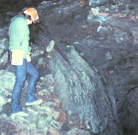
| Figure 53. Cataract Connector of Post Office Cave (see fig. 4 and map 15, pl. 5) contains late frozen lava fall that took advantage of collapse of Upper Cataract Tube into Lower Cataract Tube. Connectors allow access between tube levels within a cave. |
One can easily reach the bottom of the Cataract Connector from the upper-balcony level of the Upper Cataract Tube by skirting the north edge of the connector breakdown and working down over a rubble slope into the tube beneath the balcony at the head of the lava cataract. What now remains to indicate the position of the cataract is a steep chute, partly covered with rubble, which must have contained a river of lava at least 3-4 ft deep where it plunged into the connector. The chute slopes at an angle of 50° but its floor is obscured by loose rubble and a few rafted lava blocks welded into the floor of the chute. Bench-like curbs of frothy lava accreted to the walls of the chute as lava splashed down the cataract. These curbs permit the steep chute to be traversed with ease. Their rough surfaces, a few feet above the floor of the chute, make a natural railing that affords firm handholds when descending the cataract.
The east wall of the Cataract connector is unlike the cataract on its west wall, because where the Lower Cataract Tube (match line on map 15, pl. 5) drains the bottom of the connector to the east, the Cataract Connector is much wider than it is at the top. This widening is due to the presence of "extra walls" on the sides of the connector, which lie outside of the internal walls (see the small cross section near the end of the Lower Cataract Tube on map 15, pl. 5). The origin of these extra walls is not fully understood. Apparently when the connector first formed as a breakdown between two levels, one or more of the levels overlying the connector was filled with molten lava, and dripstone coatings developed on the walls as lava leaked through from the overlying tubes. Conditions were not uniform; however, different parts of the wall of the connector record different histories. For example, the downstream side of the connector does not show a continuation of the segment of the Upper Cataract Tube from which the lava cascade poured that mantles the upstream wall of the connector. Yet high on the wall of the downstream side, and in the appropriate position of the balcony that divides the Upper Cataract Tube into two parts, is the outline of what appears to have been a former opening. This opening, however, is now closed by at least 15 roughly horizontal layers of lava plaster 3-12 in. thick. This plaster must have accreted from beneath because lavacicles on the undersides of many layers confirm building of the layers from the top downward. Both sides of these horizontal layers are buttressed against vertical walls of dripstone. This vertical lining could only have occurred when the two levels were joined by a breakdown. At some time lava pooled within the opening and formed a horizontal crust. Repeated fluctuations of lava height within the lower tube accreted a series of these crusts until the opening was filled.
In its early stage the upper part of the Cataract Connector probably started as a breakdown between two tubes, and it later enlarged by further leakage and collapse. That the Cataract Connector had a leaky roof from even higher levels than that of the Upper Cataract Tube is shown by separate small cascades of dripstone spilling onto its walls in numerous places. At least some of these leaky spots probably formed the puzzling high cupolas with near-vertical walls that lie outside of the inner wall of the Cataract Connector and that rise in places to elevations even higher than the top of the Upper Cataract Tube. A cross section through two of these cupolas, showing their relations to different levels, is shown on map 15 (pl. 5) just right of the match line to Lower Cataract Tube. The dripstone that lines some of these cupolas must have come from lava that was active in the overlying Silver Connector level because the cupolas are higher than the roof of the Upper Cataract Tube.
The growth of dripstone-lined cupolas and alcoves, and the collapse of the deeper parts of the Cataract Connector itself, may have been triggered and extended by the presence of a lightweight cindery red breccia, which is the wall rock in this part of the cave. Similar red breccias are associated with connectors and with unusual wall collapses in other caves at Lava Beds National Monument—among them are Skull, Crystal, Kirk Whites, and White Lace Caves. This loose breccia apparently is easily penetrated and carried away by molten lava. If the breccia contains water, steam explosions occurring when molten lava invades the water-soaked breccia aid in the process (see "Skull Cave" section and map 12, pl. 4).
Lower Cataract Tube
The tube that drains the Cataract Connector narrows abruptly as it leaves the area of vertical-walled cupolas in red breccia. It runs east with a moderately steep gradient and its floor is mostly obscured by collapse rubble. Downstream 90 ft from the base of the Cataract Connector, narrow curbs of lava accreted to the walls of the tube as the lava plunged down a 3-ft cascade into a pool below. Horizontal striations occur on the walls and along smooth benches and curbs upstream from this cascade. The striations are narrow, continuous, very pronounced, and undoubtedly were caused by viscous flow and shearing against the margins of the tube as lava was forced through this constriction.
The Lower Cataract Tube is divided by a balcony into a double tube 120 ft downstream from the connector. The upper tube is smaller and can be followed for 50 ft. Its smooth pahoehoe floor ends abruptly against a dripstone wall. The lower tube beneath the balcony contains a collapsed tube-in-tube 50 ft long with a red spiny pahoehoe surface. This tube-in-tube inflated, drained, and then collapsed while its thin walls were still hot and plastic.
A ceiling collapse opens another segment of what is probably a continuation of the upper part of the tube 250 ft downstream from the Cataract Connector. Both the upper and lower passageways can be traversed downstream until they are cut off by roof collapse. The walls of the tube above the balcony contain excellent examples of dripstone. The collapse that closed both parts of the tube at this downstream end opened a high chamber in cindery red breccia 18 ft above the upper passageway.
Tubes Upstream from Cataract Connector
Two tubes, separated by a balcony, continue the Upper Cataract Tube to the west (map 15, pl. 5). The lower tube, which fed the cataract for which the Cataract Connector is named, is 3-4 ft high. Its roof is flat, and its walls lie precisely below those of the upper half of the Upper Cataract Tube. This double tube can be explained in the same way as the subfloor tube between the Red Plaster Room and the small breakdown hole 95 ft upstream: a large tube was divided into two tubes by the formation of a solid crust over a lava pond, followed by drainage of molten lava after the crust hardened.
It is tempting to assume that these two very similar double tubes were once connected as a single long tube separated because of the Cataract Connector breakdown. However, a difficulty arises with this explanation. That is, the two balcony divisions occur at slightly different elevations and therefore could not have been the crust over a single lava pool. A more likely explanation is that ponding to produce the two separate pools occurred at different times, but in similar settings. Note that at each locality the tube below the septum was drained by a cataract; the eastern cataract drained into the Red Plaster Room, and the western, or upstream, cataract drained through the Cataract Connector into the Lower Cataract Tube. A collapse in the roof of the Upper Cataract Tube, in or near the Red Plaster Room, ponded lava in the Upper Cataract Tube to a depth a little less than half of its height. Soon after a crust had formed on the surface of the lava pool, the floor of the Upper Cataract Tube gave way, cascading lava into the Red Plaster Room. Exactly the same sequence of events probably took place farther upstream during formation of the Cataract Connector.
Silver Connector Level
The Silver Connector level, which extends for most of the length of Post Office Cave, is not to be confused with the Silver Connector breakdown that connects vertically between tubes near the upstream end of the cave. This level is the highest and most extensive passageway in Post Office Cave and is over 1,700 ft long. Throughout most of their course the superposed lava tubes coalesced to form a narrow passage 30-60 ft high. Throughout most of the level the height-width ratio is greater than 3 to 1. In these high-ceilinged areas the entire floor of the Silver Connector level is deeply buried beneath collapse blocks.
The upstream and downstream ends of the Silver Connector level are indefinite because the completely collapsed central section spreads into still-uncollapsed tubes. The upper part of the Silver Connector level decreases in height and continues eastward, where it is nearly filled with lava. It eventually becomes a crawlway that continues for 30 ft to where it is plugged with congealed lava. It is open another 10 ft farther downstream as the western end of the downstream entrance level.
Part of the middle section of the Silver Connector level is equivalent to the Upper Cataract Tube, but collapse of both floor and roof prevents tracing this connection.
The upstream (western) end of the Silver Connector level is even more complex: west of the Silver Connector breakdown this level extends into parts of at least five tubes. The highest three levels are reached from Silver Cave (map 14, pl. 5), whose roof lies only 10-12 ft below the ground surface. The lowest passage extending north from the base of the Silver Connector is 85 ft below the surface but still 25 ft above the underlying Cocoa Pipeline.
Two breakdowns in the floor of the Silver Connector level give access to the Cocoa Pipeline: the eastern (downstream), Central Connector is an easy and safe passage into the pipeline; the other, 540 ft upstream, is the deep, steep-sided, and very unstable Cocoa Connector.
The Silver Connector level seems geologically uninteresting at first; its floor is nothing but a hummocky jumble of large fallen blocks that are difficult to walk over. The walls are more instructive, for patches of dripstone show the perched remains of a collapsed tube here and there, and irregular shelf-like extensions from the walls can be identified as edges of the floor of a broken-off tube. Only rarely can one see any primary features in the high and inaccessible roof. In fact, playing a strong light over this roof, 15-60 ft overhead, is a disconcerting experience when one notices the many precariously perched blocks that appear ready to fall. However, no other cave in Lava Beds National Monument provides such insights into the structure and mechanics of operation of lava tubes as does Post Office. Just as the shambles after an earthquake reveal the structural details of broken buildings, an inspection of the collapsed walls of the Silver Connector level provides details of tube construction and of the mechanics of plastic flow in lava tubes that could never be inferred from well-preserved lava tubes coated with lava plaster. A few select features of this remarkable lava-tube ruin that contribute to the understanding of lava tubes are described herein. Areas of special interest or beauty are also described. Not all features shown on the map are described herein.
The floor of the Silver Connector level, 200 ft upstream from the breakdown that connects it with the Upper Cataract Tube, is surmounted by an unusually high and steep conical pile of collapse debris. The pile rises 45 ft above the thick blanket of tumbled blocks that forms the floor of the cave. Nearby are irregular benches jutting from the wall at various points, remnants of at least three tubes that coalesced to create a cave 30-45 ft high. Farther upstream (northwest) 65 ft from the base of this huge collapse pile, the floor of the Silver Connector level drops away into the Central Connector, a breakdown 60 ft long and 6-15 ft wide. This connector gives easy access to the eastern part of the Cocoa Pipeline lava tube, 25 ft below. Before visiting this very different level, however, continue upstream in the Silver Connector level by carefully skirting the Central Connector along the top of its southeast wall. For some distance upstream from the Central Connector, the ceiling of the Silver Connector level is nearly 35 ft high and coated with off-white caliche (calcium carbonate crusts). If illuminated while wet, caliche has a highly reflective, silvery glow. Water dripping from this roof has deposited upon collapse blocks on the floor fine examples of the fragile arborescent growths of caliche popularly called "cave coral." Most growths are white, but where stained by hydrous iron and manganese oxides, organic soil compounds, or fungi, they can be deep red, lustrous black, yellow, pink, silky gray, and light blue.
The next major interruption, 540 ft farther upstream from the Central Connector, is the Cocoa Connector, a deep, unstable 22- by 15-ft hole. The descent through the Cocoa Connector to the floor of the Cocoa Pipeline, 40 ft below, is over loose and easily rolled debris. A descent here is neither recommended nor necessary because there are two safer entrances into the Cocoa Pipeline, upstream toward the Cocoa Connector, the blanket of collapse blocks on the floor thickens, and many huge blocks as much as 40 ft long are embedded in the debris. Some of these large blocks show surface features, which testify that they are large pieces of the separations between two superposed levels. Collapse over considerable areas must have occurred in places, as such large blocks surely are not due to the slow unraveling upward of roof slabs loosened along minor joints and cracks. The truncated edges of some floor benches still hanging from the walls also imply large-scale rockfalls The piles of collapse blocks are a jigsaw puzzle of surface features and the broken walls of lava tubes. It is common to find large fallen blocks with several coatings of lava plaster sliced in cross-section on one or more broken edges.
Downstream 65 ft from the Cocoa Connector, the Silver Connector level makes a 45° turn to the left (as viewed looking upstream) and heads almost due south. The Cocoa Pipeline below turns the same corner with an even sharper bend. The effect of a sharp bend in the original, pre-lava topographic valley in controlling the superposition of the two lava tubes seems clear, because the curve became gentler as the pre-flow depression was filled in.
The dangerous Cocoa Connector can be skirted safely on its northwest side. Once around it one climbs a steep 15- to 20-ft pile of collapse rubble. In another 190 ft is the large vertical hole through several levels called the Silver Connector.
Silver Connector
The breakdown 190 ft upstream from the Cocoa Connector (map 15, pl. 5) has for several years been called the Silver Connector (fig. 51) because its top is in Silver Cave. It extends vertically for 60 ft and passes through several levels. Its base is in a short tube that slopes north for an additional 25 ft and ends in a rounded pocket 85 ft below ground, but above the floor of the Cocoa Pipeline. Details of some lava tubes that intersect the Silver Connector have not been worked out because they are inaccessible, and the edges of all levels that intersect the connector are very loose. Moreover, the top three lava tubes can only be approached by a difficult crawl through a constriction in Silver Cave.
The Silver Connector level changes markedly near the Silver Connector and upstream from it. It spreads out into at least seven superposed lava tubes, all of which were truncated by the collapses that formed the Silver Connector. The tube that we call Lower Entrance Tube is readily accessible from the base of the Silver Connector.
Lower Entrance Tube
To enter the Lower Entrance Tube from the base of the Silver Connector, you must pick your way upstream beneath a natural bridge and then up a steep rubble slope into the tube. Farther upstream 50 ft another breakdown, only 8 ft deep, interrupts the floor of the tube for another 45 ft. From the upstream end of this breakdown it is possible to descend through an opening and work down into still lower tubes; we continue, however, in the main part of the Lower Entrance Tube.
This tube has ceiling heights of 10-12 ft and is characterized by thin layers of accretionary lining that are partly peeled away from its walls and ceiling. Upstream 240 ft from the Silver Connector, these accretionary linings arch steeply from the tube's walls and in places are vertical along the axis of the roof. The roof has a steep gable instead of a rounded top. The tube continues to narrow upstream to the Veritable Venturi and acquires an A-frame shape (fig. 54) where it makes a smooth 70° turn to the right (west). Just beyond this turn, 290 ft upstream from the Silver Connector, a breakdown closes the continuation of the tube to the west but permits one to climb into the upper entrance level and continue to the cave exit, a tight crawlhole leading to the surface.
|
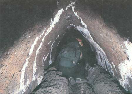
| Figure 54. Small triangular-shaped passage was left in Post Office Cave (see fig. 4 and map 15, pl. 5) when late, stiff lava flow failed to fill tube and formed pronounced lava curbs. Triangular shape may have been caused by inward slumping of tube walls. |
Cocoa Pipeline
The 1,040-ft-long Cocoa Pipeline, approximately 110 ft below the surface, is the deepest well-preserved lava tube in the upstream half of Post Office Cave. This tube is oval in cross section and, except at one small cascade near its downstream end, measures 12-14 ft high and 18-20 ft wide. The pahoehoe floor has an overall gradient of less than one degree. The oval cross-section is close to the ideal hydraulic form to be expected of a heavy liquid flowing through a viscous medium. The thick roof that separates the tube from the overlying Silver connector level also indicates that the Cocoa Pipeline developed in an unusually thick lava flow, perhaps near the bottom of the first major flow to occupy the inferred canyon or valley that determined the site of the superposed lava tubes comprising Post Office Cave.
The Cocoa Pipeline is nearly intact, with very little collapse except at the two connectors that join it with the overlying level. There are four possible entrances through the roof of the Cocoa Pipeline: the Central and Cocoa Connectors and two upstream-end crawlways leading through collapse blocks within an overlying maze of partly collapsed small tubes. The evolution of the collapse-free Cocoa Pipeline contrasts strikingly with that of the Silver Connector level. The Pipeline seems to have been little affected by the complex series of breakdowns, drainings, and recurrent lava fillings that characterize the overlying levels. Its basal position and its thicker roof may have allowed it to remain insulated and full of molten lava during fluctuation of lava in the shallower levels. Some of the draining and refilling in upper tubes may have been caused by surging of lava upward through connectors as hydraulic pressure changed within the completely filled Cocoa Pipeline.
The accessible part of the Cocoa Pipeline lacks tributaries or distributaries and is so uniform in shape that routine description of its upstream course is unnecessary. Only a few of the more interesting localities are described.
The Central Connector, along the eastern (downstream) collapse from the Silver Connector level, provides an easy entry into the Cocoa Pipeline. Downstream 100 ft from the Central Connector, the Cocoa Pipeline is blocked by a roof collapse. This blockage is directly beneath the upstream edge of the huge collapse pile, which rises 45 ft above the floor of the overlying Silver Connector level. Perhaps a hidden connector filled with lava and collapse debris is buried within this huge collapse pile. Such a connector might extend all the way from 15 ft below the surface to the Cocoa Pipeline. The Cocoa Pipeline's downstream continuation beyond this blockage appears to be the Lower Cataract Tube. The elevations are compatible because the lowest accessible point in the Lower Cataract Tube is 139 ft below the surface (map 15, pl. 5). Yet the upper part of the Cocoa Pipeline is much simpler in form than the irregular-walled structure of the Lower Cataract Tube. This difference in form, however, may only be the result of the Lower Cataract Tube having to make its way, at least in part, through the red pyroclastic tuff and breccia.
The Cocoa Pipeline can be followed upstream for 1,040 ft to where it is blocked by a collapse. Only 25 ft upstream from the downstream end, a small 10-ft mound of breakdown on the floor and corresponding dome in the roof record the beginning of a new collapse. Next we come to the Central Connector; this collapse from the Silver Connector level has built a mound 10 to 20 ft high and 70 ft long on the floor of the Cocoa Pipeline.
Another 100 ft farther upstream from the Central Connector, the floor rises 3 ft in a short lava cascade. Here the pipeline constricts to only half its downstream width. Above the cascade the tube widens, and narrow floor-level benches 2 ft high are present on both sides for 200 ft upstream. Below the cascade, in the constricted part of the tube, the equivalent of the 2-ft bench is a collapsed tube-in-tube, which litters the floor of the pipeline.
The next point of interest upstream is the Cocoa Connector, an opening that left a steep-sided conical pile of debris 18 ft high on the floor of the pipeline. The roof of the overlying level, visible through this connector, is 78 ft above the floor of the Cocoa Pipeline.
Nearly 200 ft upstream from the Cocoa Connector, lava stalagmites (fig. 10) are found on the floor of the Cocoa Pipeline and extend in a line for 40-50 ft. A few are quite large—as much as 2 ft in diameter and 3 ft high. It is puzzling that none of these stalagmites appear to have an obvious source of lava drippage on the ceiling directly above them. One might assume they were rafted on a partly solidified lava crust to their present position from a source farther upstream. A possible source might be a small cataract, which delivered lava through the roof of the Cocoa Pipeline from the overlying Cocoa entrance level, near the point where the Cocoa Pipeline is blocked by a collapse at its upper end. It is also possible that a series of localized ceiling hot spots may have caused the ceiling lining to melt and thus form the stalagmites.
The upstream blockage of the Cocoa Pipeline is a slope of fallen blocks, which rises steeply and joins the funnel of coarse blocks that collapsed from the level above (see longitudinal section on map 15, pl. 5). From the roof of the Cocoa Pipeline near its right (north) wall, a small but conspicuous vertical crawlhole rises between fallen blocks into the tip of this steep funnel of loose and precariously balanced blocks. This is not the preferred exit to the higher level because it is extremely unstable. Directly across the Cocoa Pipeline from this hole in its roof, but down at the level of the sloping debris on the floor, is another inconspicuous crawlway. It pierces the left (south) wall of the pipeline and except for the first 3 ft is a roomy crawl, which can be easily negotiated by a large man. After 16 ft one reaches a wider incline that is the surface of a lava cascade. There is little difficulty in scrambling up this lower angle cascade, even though much of it is mantled by collapse blocks. Within 40 ft one emerges in a small collapse that opens into the upstream portion of the Cocoa entrance level.
Cocoa Entrance Level
The Cocoa entrance level on map 15, plate 5 is offset from its actual position for clarity. The various parts of the Cocoa entrance level are badly ruined by collapse so that they are of perhaps lesser interest to either the lay visitor or geologist, but this level does furnish a shortcut exit from Post Office Cave.
The geometry of the Cocoa entrance level is irregular horizontally and vertically. The main elements are a passage way 200 ft long and a sublevel of half this length beneath its downstream part. In addition, the large cascade is an inclined distributary extending from the Cocoa entrance level's floor into the Cocoa Pipeline. The lava that formed the stalagmites downstream in the Cocoa Pipeline may have dripped from this cascade onto the sluggishly moving lava in the Cocoa Pipeline.
The surface can be reached from this complex collapse ruin by following the steps described. First crawl up the cascade into a large room 50 ft wide. Turn and cross over to the opposite (east) wall of this room, edging south around the top of the steep funnel of collapse debris. Follow the east wall of the room uphill (north) into a small branch tube for 40 ft. Here a hole between collapse blocks leads upward into the lower entrance level, which is an upstream extension of a part of the Silver Connector level. Just after climbing out of the lower Cocoa entrance level, reverse direction and walk upstream (south) around a broad curve to the upstream end of the lower entrance level and then through a shallow connector into the upper entrance level. Continue upstream for 220 ft, where the upper entrance level ends in a dirt-covered slope that rises higher into a snug vertical chimney that opens to the surface.
Upper Entrance Level
The upper entrance level can be examined both upstream and downstream from where it intersects the Veritable Venturi. The exit is upstream (southwest). Downstream it extends 120 ft to where it is filled with lava. Downstream, the ceiling heights drop, the walls narrow, the tube takes on an A-frame cross section (fig. 54) like that in the Veritable Venturi beneath, and the walls have spiny pahoehoe benches 1 ft high that curb a shallow central channel.
Upstream from its intersection with the Lower Entrance Tube, the tube is larger and farther upstream the floor is entirely covered with collapse debris. Ceiling heights increase markedly 50 ft upstream from the breakdown, where the remains of a filled lava tube can be seen in the roof. A steep-sided collapse pile covers the floor a little farther upstream, and the tube widens to 50 ft in the area of this collapse. The floor of the tube then descends to a low spot on the upstream side of this collapse pile, and from there a soil-covered slope leads upstream to the vertical chimney, which is the upstream exit from Post Office Cave (fig. 55).
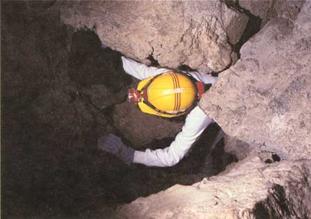
|
| Figure 55. Explorer emerges from narrow exit of Post Office Cave (see fig. 4 and map 15, pl. 5). Information about cave access, along with safety and exploration guidelines are obtained at Visitor Center in Lava Beds National Monument. |
Lava Transport
Using average underground flow rates of 0.6-3.6 mi per hour, as determined by Peterson and Swanson (1974) from observations through skylights on active lava tubes in Hawaii, the volume of lava transported in a full tube of known cross-sectional area can be calculated. Assuming these Hawaiian flow rates and the same gradient, a tube the size of the Cocoa Pipeline could transport 14-86 million cubic feet of lava per day, the lower number being comparable to typical Hawaiian eruption rates (Peterson and Swanson, 1974). At least five large lava-tube systems operated during emplacement of the basalt of Mammoth Crater, although they were probably not all active at the same time. The five are, from west to east, (1) Upper Ice Cave, (2) north of Bearpaw Butte, (3) Bearpaw-Skull, (4) Heppe-Cave Loop Road-Post Office-Craig, and (5) Hidden Valley. Volume is estimated to be nearly 1.2 cubic miles covering approximately 100 square miles and spreading west and east beyond the boundaries of the monument (fig. 1). The basalt of Mammoth Crater also possesses a single remanent paleomagnetic direction, and this data suggests a very short duration, perhaps as little as a decade, for emplacement of the entire unit (Donnelly-Nolan and Champion, 1987). If 1.2 cubic miles of basalt were emplaced in 10 years, the calculated flow rate would be 48 million cubic feet per day; this figure is slightly more than three times higher than the typical Hawaiian flow rates cited by Peterson and Swanson (1974) but within the range of Hawaiian eruption rates. If the basalt of Mammoth Crater erupted at approximately the same rate as in a typical Hawaiian eruption, 30 years may have been required for the eruption. Note that Post Office tubes transported a large volume of lava (at least some of which probably traveled through Craig Cave tube) 5 to 10 mi to the east and northeast from the east monument boundary nearly to California Highway 139. However, some of this large expanse of basalt of Mammoth Crater may have been transported by the inferred Hidden Valley tube system, which is buried by the basalt of Valentine Cave.
Intermittent changes of hydraulic pressure and flow rate occur within such a tube system. Also, roof collapses that partially or completely plug flowing tubes affect the hydraulic pressure within tube systems. Pooling of lava behind an annealed flow front or a lava collapse, along with short-term fluctuations in eruptive rates, probably represented the only conditions under which any of the Post Office tubes were completely filled with lava for an extended period of time, with the possible exception of the Cocoa Pipeline. Tube-in-tubes, smooth pahoehoe benches, and the many thin accretionary linings in the tubes of Post Office Cave support this reasoning, for they record repeated periods of pooling, withdrawal, and refilling with lava.
| <<< Previous | <<< Contents >>> | Next >>> |
bul/1673/sec3g.htm
Last Updated: 28-Mar-2006